You’ll find four remarkable ghost towns within an hour of Henderson, each telling a different chapter of Nevada’s mining history. Nelson’s Techatticup Mine, 25 miles southeast, produced $10 million in precious metals where vigilantes ruled. St. Thomas, founded by Mormons in 1865, disappeared beneath Lake Mead in 1938 and re-emerged in 2002. Goodsprings, 30 miles southwest, yielded $31 million during WWI’s metals boom. Potosi marks Nevada’s first lode claim from 1856, where Mormon settlers extracted 9,000 pounds of lead before abandoning it a year later—and each site offers deeper stories worth exploring.
Key Takeaways
- Nelson Ghost Town, 25 miles southeast, features the restored Techatticup Mine and vintage equipment as an open-air museum.
- St. Thomas ruins emerged from Lake Mead in 2002, showing foundations and cisterns from the 1865 Mormon settlement.
- Goodsprings, 30 miles southwest, combines historic storefronts, mining infrastructure, and an 1890 cemetery with active community elements.
- Potosi (Crystal City) marks Nevada’s first lode mine from 1856, located 30 miles southwest with scattered historical remnants.
- Each ghost town reflects different eras: Spanish exploration, Mormon settlement, mining booms, and World War I defense production.
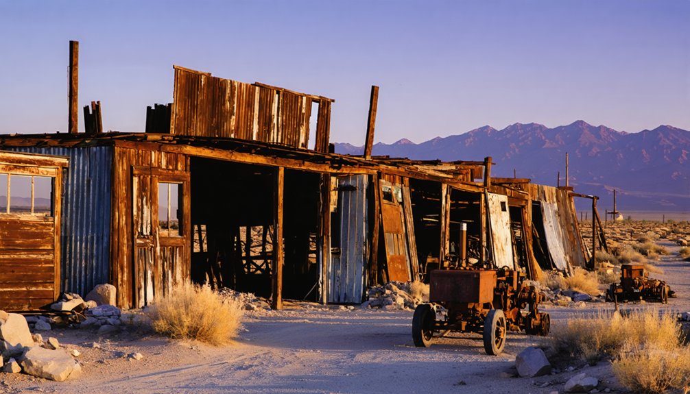
Nelson Ghost Town & Eldorado Canyon
About twenty-five miles southeast of Las Vegas, where Eldorado Canyon cuts through rugged desert hills toward the Colorado River, lies one of southern Nevada’s most storied—and bloodiest—mining camps.
Spanish explorers christened it Eldorado in 1775 after striking gold, launching Eldorado history that would span nearly two centuries. The 1860s rush brought fortune-seekers and outlaws alike to the Techatticup Mine, which yielded $10 million in precious metals by 1945.
With the nearest sheriff a week’s ride away in Pioche, vigilante justice ruled this violent frontier. Nelson legends grew from daily gunfights and the 1897 massacre of prospector Charles Nelson—whose name replaced Eldorado on the map. The pattern of violent deaths throughout the mining boom has led many to believe residual energy lingers in the area.
Civil War deserters, Prohibition smugglers, and flash floods cemented the canyon’s deadly reputation. Today, Tony and Bobbie Werly’s 1994 restoration efforts have transformed the abandoned mine grounds into a popular tourist destination featuring ghost town remnants and guided mine tours.
St. Thomas: Lake Mead’s Sunken Settlement
Where the Muddy and Virgin Rivers converge in what’s now Lake Mead National Recreation Area, the drowned streets of St. Thomas tell a story of sunken history you can walk through when drought lowers the reservoir.
Founded in 1865 by Mormon settlers under Brigham Young’s direction, this farming community thrived on irrigated cotton and corn until an 1870 survey suddenly placed it in Nevada.
Faced with crushing back taxes payable in gold, residents burned their homes and left in 1871. The town rebuilt, peaked at 500 souls, and served motorists on the Arrowhead Trail until Hoover Dam sealed its fate.
Hugh Lord, the final resident, departed by boat on June 11, 1938, as water reached his doorstep—ending decades of abandoned agriculture beneath sixty feet of water.
The town remained submerged until 2002, when dropping water levels finally revealed the ruins again.
Today, visitors can access the exposed ruins from a graded dirt road that extends 3.5 miles from Highway 169, south of Overton, requiring a park entrance fee to explore the foundations and streets of this once-thriving settlement.
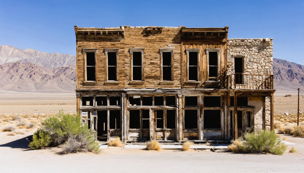
Goodsprings: A Living Piece of Mining History
Thirty miles southwest of Las Vegas in the southern Spring Mountains, Goodsprings stands as Nevada’s most mineral-diverse district—a living ghost town where early-1900s storefronts frame streets once trampled by 800 residents riding the World War I metals boom.
Goodsprings history began with 1886 lead discoveries, evolving into a $31-million producer after the Yellow Pine Mining Company‘s 1905 revelation: miners had been discarding high-grade zinc ore for years. That recognition transformed operations, and by 1918 the district had shipped 85 million pounds of zinc to feed wartime demand.
Mining legacy runs deep here—one-third of Clark County’s metal production flowed from these hills, where 37,000 tons of lead and rare platinum-group metals emerged. The district earned recognition as Nevada’s most varied mineral producer, yielding not just lead and zinc but also gold, silver, copper, molybdenum, vanadium, nickel, cobalt, and even uranium. The company built a large smelter near Goodsprings by 1910 to process the ore extracted from the surrounding mines.
The 1911 narrow-gauge railroad’s ruins and Joseph Good’s springs still anchor this semi-ghost settlement.
Potosi (Crystal City): Nevada’s First Mining Claim
You’ll find Nevada’s mining history began in 1856 when a Paiute guide led Mormon missionaries to a lead deposit on the western slope of the Spring Mountains, creating what’s widely regarded as the state’s first lode mine.
Those early Mormon settlers extracted roughly 9,000 pounds of lead for bullets before abandoning the camp in early 1857—making Potosi both Nevada’s first mine and first ghost town. The mine was named after Nathaniel V. Jones’ hometown in Wisconsin.
During World War I, the mine gained new strategic importance as a priority defense project, producing critical zinc, silver, and lead for the war effort under the Empire Zinc Company’s operation.
Today, you’ll need to navigate remote mountain roads about 30 miles southwest of Las Vegas to reach the scattered remnants of what later became known as Crystal City during its 1870s revival.
Mormon Mining Legacy Beginnings
Mormon mining expeditions pushed thirty miles southwest into rugged terrain, locating the Potosi deposit and establishing Nevada’s first lode mine.
They built crude adobe smelters, packed ore down by mule, and erected a secondary smelter inside the Las Vegas stockade—the first west of the Missouri River.
Before abandoning operations in early 1857, they’d extracted 9,000 pounds of lead, establishing a blueprint for Nevada’s hard-rock future.
California mining interests reopened the abandoned Potosi mine in 1861, constructing rock cabins to house up to 100 miners and establishing a more sophisticated smelter for processing operations.
J.A. Talbott published a handwritten newspaper in the revived settlement, documenting the brief resurgence of mining activity.
Lead Discovery of 1847
In spring 1856, a Paiute guide revealed the location of mineral deposits gleaming on the western slope of the Spring Mountains, thirty miles southwest of the Las Vegas Mission.
You’ll find this discovery marked Nevada’s inaugural leap into industrial mineral extraction. Nathaniel V. Jones rode from Salt Lake City to investigate, christening the site “Potosi” after his Wisconsin birthplace.
While records officially date this find to 1856, whispers persist of Mexican or Native American lead mining activity from the 1830s—though evidence remains elusive.
The site’s historical significance extends beyond mere chronology; it established Nevada’s first lode claim, preceding the silver rushes that’d define the territory.
This remote outcrop transformed into a proving ground where frontier ambition met geological reality.
Remote Mountain Access Today
The once-bustling operations at Potosi now lie silent beneath Nevada’s desert sky, yet the journey to this historic site remains an adventure worthy of its frontier legacy.
You’ll navigate the same rugged terrain that challenged those 1856 Mormon miners, though modern vehicles have replaced their mule trains.
Essential knowledge for your expedition:
- Mountain trails remain primitive and unmaintained, requiring high-clearance 4WD vehicles
- The route follows steep switchbacks up the Spring Mountains’ western slope where Nathaniel V. Jones first surveyed the deposits
- Mining access roads, originally carved for the aerial tramway installation in 1913, still trace the mountainside
- Crystal City’s stone ruins sit near Potosi Spring, approximately 700 feet below the original mine entrance
You’re free to explore Nevada’s first lode claim without permits or fees.
Exploring the Ghost Town Landscape Around Henderson
Within an hour’s drive from Henderson’s suburban master-planned developments, you’ll find a stark collision of Nevada’s boom-and-bust history etched across three distinct landscapes.
Nelson’s Techatticup Mine stands forty-five minutes south, where restored buildings and vintage equipment create an open-air museum prized for ghost town photography.
St. Thomas emerges from Lake Mead’s receding shoreline, its 1865 foundations and cisterns forming a trail system through what sixty feet of reservoir water once concealed.
Southwest, Goodsprings operates as Nevada’s living contradiction—an active school alongside historic mining artifacts, miner cabins, and an 1890 cemetery.
Each site preserves different chapters: Indigenous through Civil War-era occupation at Nelson, federal dam displacement at St. Thomas, and ongoing community persistence at Goodsprings, where the territorial-era saloon still serves visitors traversing Nevada’s layered mining frontier.
Rhyolite: A Desert Ruin Worth the Drive
While Henderson’s nearest ghost towns offer compelling half-day excursions, Rhyolite demands a full commitment—a two-hour northbound drive that crosses the Amargosa Desert and climbs into the Bullfrog Hills near Death Valley’s eastern edge.
Rhyolite history begins with 1904’s gold strike and explodes into a 10,000-resident boomtown by 1905, complete with three railroads, multi-story banks, and the Montgomery-Shoshone Mine’s $1 million yield.
By 1920, fourteen souls remained.
Today’s Rhyolite attractions include:
- Cook Bank Building – the West’s most photographed ghost-town ruin
- Tom Kelly’s Bottle House – Nevada’s premier bottle-construction survivor
- Railroad depot – pristine compared to surrounding decay
- Commercial district foundations – mapping boomtown ambition across desert hardpan
You’ll photograph structures the BLM preserves as historical monuments while wind whistles through empty doorframes.
Frequently Asked Questions
Are Ghost Town Visits Near Henderson Safe for Children and Families?
Yes, with proper precautions. You’ll find family activities like Nelson’s guided tours and Clark County Museum’s exhibits guarantee child safety through managed access, shade, and supervision—far safer than remote ruins requiring vigilant heat and terrain monitoring.
What Permits or Fees Are Required to Explore Ghost Towns?
Most BLM ghost towns require no permit for casual exploration—roughly 80% remain open—though commercial photography demands special recreation permits. You’ll find fee structures vary: state parks charge entrance fees, while federal lands stay wonderfully free for individual adventurers.
Can I Camp Overnight Near These Ghost Town Sites?
You’ll find camping regulations vary by location—BLM lands typically allow 14-day dispersed stays, while Lake Mead sites require designated campgrounds. Always verify current restrictions and practice overnight safety protocols, respecting private property boundaries near historic townsites.
What’s the Best Time of Year to Visit Desert Ghost Towns?
Late fall and spring offer ideal desert temperatures—mild days, cool nights—for exploring ghost towns. You’ll dodge summer’s dangerous heat while catching seasonal attractions like spring wildflowers, giving you maximum freedom to roam these abandoned sites safely.
Are Four-Wheel-Drive Vehicles Necessary to Reach These Locations?
You won’t need four-wheel drive for paved-access Nelson, Goodsprings, or St. Thomas. Vehicle recommendations emphasize high-clearance for graded routes, though four-wheel drive advantages emerge when exploring remote mining camps beyond maintained roads.
References
- https://en.wikipedia.org/wiki/List_of_ghost_towns_in_Nevada
- https://www.reviewjournal.com/local/local-nevada/abandoned-but-not-forgotten-5-ghost-towns-in-southern-nevada-3351038/
- https://travelnevada.com/ghost-town/ghost-towns-near-las-vegas/
- https://nvtami.com/2023/12/05/las-vegas/
- https://www.geotab.com/ghost-towns/
- https://www.tripadvisor.com/Attraction_Review-g1093759-d4446411-Reviews-Nelson_Ghost_Town-Nelson_Nevada.html
- https://www.youtube.com/watch?v=I6XIMMCqilU
- https://www.exploratography.com/blog-nv/eldorado-canyon-nelson-ghost-town-nevada
- https://brocarde.com/nelson-nevada-visiting-an-abandoned-ghost-town-and-finishing-ghosts/
- https://www.youtube.com/watch?v=MlH4SKnmgao


