You’ll find St. Thomas, a Mormon farming settlement submerged since 1938, emerging from Lake Mead during droughts about 60 miles northeast of Hoover Dam. The town was abandoned when the reservoir filled, leaving concrete foundations, street grids, and building remnants now accessible via a National Park Service hiking trail. Nearby lies the Lost City, ancient Puebloan villages dating from 300-1150 A.D., also flooded by the dam. The Lost City Museum in Overton houses salvaged artifacts from both settlements, preserving what couldn’t be left behind.
Key Takeaways
- St. Thomas, founded in 1865 and submerged in 1938, is now visible due to Lake Mead’s drought near Hoover Dam.
- The town was abandoned twice: first in 1871 due to tax disputes, then permanently in 1938 before Lake Mead’s flooding.
- Visitors can explore foundation walls, street grids, and building remnants along a National Park Service hiking loop with interpretive signs.
- Lake Mead also submerged Callville and Ancestral Puebloan Lost City sites dating from A.D. 300–1150 containing hundreds of structures.
- Best visiting season is fall through spring; bring extra water and sun protection as the area has no shade.
St. Thomas: the Town That Rose From Lake Mead
When Mormon pioneers arrived at the confluence of the Muddy and Virgin Rivers in 1865, they found fertile soil that promised agricultural prosperity in an otherwise harsh desert landscape.
Led by Thomas S. Smith, these settlers established St. Thomas, which grew to 500 residents and became Pah-Ute County’s seat.
The pioneer settlement faced its first abandonment in 1871 when Nevada officials demanded back taxes in gold.
Rather than submit to what they saw as unjust taxation, St. Thomas residents chose to burn their own homes and abandon the settlement.
Refusing government overreach, residents burned their homes and left.
St. Thomas history took another turn when the community rebuilt in the early 1900s as a mining and farming town.
However, the 1928 Boulder Dam Act sealed its fate.
How Hoover Dam Created Underwater Ghost Towns
St. Thomas wasn’t alone in succumbing to Lake Mead’s rise. When Congress authorized Hoover Dam in 1928, federal planners mapped inundation zones across the Muddy and Virgin River valleys, condemning settlements that would disappear beneath 1,220 feet of water.
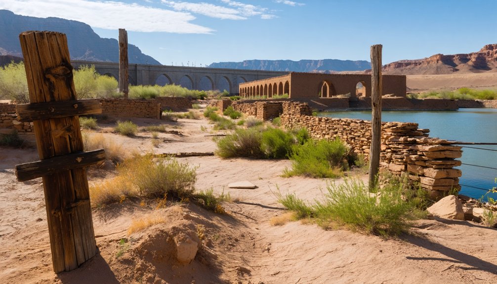
Callville, an 1860s Mormon steamboat landing and Colorado River freight hub, was abandoned and submerged under what’s now Callville Bay—today’s marina sits atop drowned docks and foundations.
Even older losses occurred upstream, where Ancestral Puebloan “Lost City” sites dating to A.D. 300–1150 vanished despite salvage excavations.
Underwater archaeology now documents these submerged ghost towns, though historical preservation efforts came too late for many structures left in place. Historical graves and cemeteries were often left undiscovered or intact beneath the reservoir due to family wishes.
When drought lowers the reservoir, you’ll glimpse pueblo walls and building remnants reclaiming their stories from the deep. St. Thomas had reached a peak population of about 500 residents in the 1880s before the waters claimed it.
Exploring the Ruins of St. Thomas Today
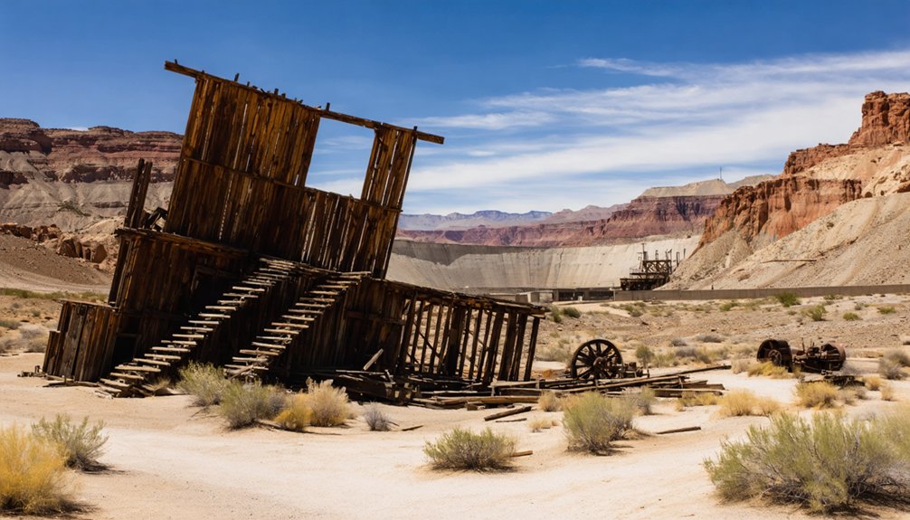
Where else can you walk down streets that spent seven decades underwater? St. Thomas’s exposed ruins let you trace the original grid where farmers, merchants, and railroad workers built Nevada’s oldest Mormon settlement in 1865.
The National Park Service maintains a hiking loop through foundation walls and building plots, marked by interpretive signs displaying historic photographs and explaining the town’s historical significance—from pioneer orchards through forced evacuation under the 1928 Boulder Dam Act.
Before exploring, review visitor guidelines: stick to designated trails, don’t climb fragile walls, and leave all artifacts untouched. Bring serious sun protection and water; there’s zero shade across this Mojave Desert site. Among the most recognizable remains is the Hanning Store and Ice Cream Parlor, which was the first building to reemerge from the lake.
Fall through spring offers tolerable temperatures. Access the trailhead via graded dirt road off Northshore Road, then walk freely among ghosts of hotels, schools, and homes reclaimed from Lake Mead’s receding waters. The town was submerged under approximately 80 feet of water when Lake Mead filled behind Hoover Dam.
The Lost City: Ancient Puebloan Villages Beneath the Reservoir
Long before St. Thomas was founded, you’ll find that the lower Moapa Valley supported a vast network of Ancestral Puebloan settlements archaeologists called Pueblo Grande de Nevada—stretching sixteen miles along the riverbanks that now lie beneath Lake Mead’s Overton Arm.
Between 1924 and the reservoir’s filling in the 1930s, excavators documented hundreds of pit houses, multi-room pueblos, and salt mining operations dating from 300 A.D. to roughly 1150 A.D. The inhabitants cultivated corn, squash, and beans while supplementing their diet with rabbits and desert tortoises from the surrounding desert.
The site’s submersion represents one of the most significant archaeological losses in the American West, with only salvaged artifacts and pre-inundation records preserving evidence of this complex civilization. Mark Raymond Harrington led efforts to document and preserve the site before the waters from Hoover Dam’s construction permanently submerged these ancient ruins.
Pueblo Grande De Nevada
Beneath the turquoise waters of Lake Mead lies Pueblo Grande de Nevada, a sprawling complex of ancient villages that once thrived along the fertile Muddy River corridor near present-day Overton.
You’ll find evidence of occupation stretching back to 8000 BC, though permanent settlement began around 300 A.D. with Basketmaker groups who developed ancient irrigation systems to cultivate maize in this harsh desert environment.
The Ancestral Puebloans transformed these settlements into architectural marvels, constructing multi-room structures—some exceeding 100 rooms—using pueblo architecture techniques that marked the westernmost reach of their civilization.
They traded turquoise, woven cotton, and coastal shells across vast networks while mining salt from nearby deposits.
Their sophisticated agricultural center flourished until approximately 1150–1250 A.D., when these communities mysteriously abandoned this remarkable oasis.
Jedediah Smith discovered various artifacts at the site during his 1827 expedition through the region.
In 1924, brothers Fay and John Perkins alerted Governor James Scrugham to the ruins, leading to systematic excavations that would preserve thousands of artifacts before the Colorado River’s damming flooded these ancient sites forever.
Lake Mead Archaeological Impact
When engineers flooded the Colorado River basin in 1935 to create Lake Mead, they submerged sixteen miles of the Muddy River corridor containing what archaeologists now call Lost City—hundreds of pit-houses, pueblos, salt mines, and campsites that represented the westernmost expansion of Ancestral Puebloan civilization.
You’ll find the most developed sections still beneath the Overton arm, five miles south of Overton. The Civilian Conservation Corps raced against rising waters to salvage what they could, recovering artifacts that now fill the Lost City Museum.
These archaeological discoveries documented continuous occupation from 300 A.D. to 1150 A.D., including a 174-room complex that demonstrated sophisticated planning.
Today, this submerged history remains largely inaccessible, preserved but hidden beneath federal waters—a reflection of civilization buried by government infrastructure.
Mormon Settlements Abandoned Along the Muddy River
In late 1864, Brigham Young ordered colonization of the Muddy (Moapa) River Valley as part of the “Muddy Mission,” intending to expand LDS agricultural outposts into what settlers believed was Utah or Arizona Territory.
You’ll find that St. Thomas, founded January 1865, led these Mormon settlements with 600 acres divided into five-acre irrigated farm lots.
By 1870, boundary surveys placed the Muddy River communities squarely in Nevada. State authorities demanded years of back taxes payable in gold—an impossible burden for agrarian colonists.
When Nevada tax collectors arrived demanding payment in gold for years of back taxes, the struggling farmers faced an impossible choice.
Rather than comply, most residents abandoned St. Thomas, Overton, St. Joseph, and West Point by February 1871, resettling in Long Valley, Utah.
The exodus marked one of the region’s most dramatic instances of government overreach forcing entire communities to flee.
When Lake Mead Water Levels Reveal Hidden History
When drought drops Lake Mead to record lows, you’ll witness St. Thomas—a Mormon farming community that disappeared beneath 60 to 80 feet of water in 1938—reemerge along the receding shoreline.
Foundation walls, street grids, and the remains of an ice cream parlor chimney now mark the townsite that has surfaced repeatedly during dry cycles in 1945, 1963, and continuously since 2004.
Beyond the historic settlement, falling water levels expose ancient Puebloan village sites and irrigation features that National Park Service archaeologists race to document before the next flood cycle.
St. Thomas Emerges Again
For over six decades, the desert waters of Lake Mead kept St. Thomas hidden beneath 60–70 feet of water.
You’ll find that this submerged history finally resurfaced in 2002 when prolonged drought dropped reservoir levels dramatically. The last resident, Hugh Lord, rowed away on June 11, 1938, reportedly torching his house as Lake Mead rose to swallow the Mormon settlement.
Today, you can hike directly to the ruins within the Overton Arm, where building foundations and former streets lie exposed on cracked lakebed.
The National Park Service manages this site of archaeological significance, installing interpretive signs that reveal stories of displacement and western expansion.
St. Thomas stands as stark evidence of water scarcity—a ghost town reborn through climate change and reservoir contraction.
Foundations and Street Grids
As Lake Mead contracts, the geometric precision of St. Thomas’s street grid emerges from the lakebed, transforming submerged archaeology into measurable history.
You’ll find concrete foundations and roadbed traces aligned to the original river corridor, not the reservoir shoreline. Foundation analysis reveals construction patterns that survived decades underwater:
- Commercial core blocks – wider lots along Main Street with thicker concrete slabs marking hotel and store footprints
- Residential grids – uniform setbacks and smaller foundation pads extending toward agricultural plots
- Cisterns and root cellars – subfloor features documenting pre-dam water storage
- Wave-erosion patterns – differential foundation wear mapping historic pool elevations
The grid layout serves dual purposes: archaeological template and hydrological gauge.
Each exposed street segment carries sediment layers marking successive droughts, creating a physical record of Colorado River decline.
Drought Exposes Archaeological Data
Since Lake Mead’s water levels fell to 1,041 feet in July 2022—roughly 27% of storage capacity—the reservoir’s receding shorelines have transformed into an open-air archaeological laboratory where previously submerged cultural deposits spanning millennia now await systematic documentation.
You’ll find Ancestral Puebloan habitation zones from the “Lost City” re-emerging alongside Mormon farming settlements that vanished beneath rising waters in the 1930s.
Historians often highlight ghost towns near Albuquerque history as sites of cultural significance, where echoes of past communities whisper through the ruins. Exploring these abandoned places can offer a glimpse into the lives of those who once thrived in the region, enriching our understanding of New Mexico’s diverse heritage. Each ghost town serves as a reminder of both prosperity and decline, inviting visitors to reflect on the stories that shaped the landscape.
National Park Service archaeologists prioritize recording stone tools, pottery sherds, and metal farm equipment with precise provenience data—spatial context that determines archaeological significance.
Archival photographs now align with exposed foundations, enabling you to reconstruct pre-dam community layouts.
This drought-driven revelation underscores urgent cultural preservation needs: artifacts documented in situ become research assets, while unrecorded finds lose irreplaceable historical value.
Planning Your Visit to the St. Thomas Site and Lost City Museum
When should you explore the submerged streets of St. Thomas? Plan your expedition during cooler months—October through April—when Mojave Desert temperatures won’t overwhelm you on this shade-free trail.
Smart visitor logistics begin at Overton’s Lost City Museum, where archival exhibits contextualize what you’ll encounter among the ruins.
Start your journey at Overton’s Lost City Museum to understand the historical context of the submerged ruins you’re about to explore.
Essential trail safety preparations:
- Water and Protection: Carry twice what you’d typically need; no services exist at the townsite.
- Footwear: Sturdy hiking boots for traversing uneven desert terrain and crumbling foundations.
- Weather Monitoring: Check Lake Mead NRA advisories for flash flood warnings during monsoon season.
- Federal Compliance: Respect artifact protection laws—disturbing structural remains carries serious penalties.
The unpaved access road off Northshore Road handles passenger vehicles in dry conditions, though you’ll want current condition reports before departing.
Frequently Asked Questions
Were Any Human Remains Found When St. Thomas Re-Emerged From Lake Mead?
You’ll find that human remains were discovered at Lake Mead during St. Thomas’s re-emergence, though records don’t directly link the bodies to the settlement’s 1938 submersion. Five sets surfaced during 2022’s severe drought conditions.
Can You Camp Overnight Near the St. Thomas Ruins?
No, you can’t camp overnight at St. Thomas ruins—NPS camping regulations prohibit it due to area closures protecting the site’s history. You’ll need to use developed campgrounds elsewhere in Lake Mead National Recreation Area.
What Happened to the Original Buildings Before the Town Was Flooded?
Time swept through St. Thomas like an unwelcome tide—you’ll find no building preservation or historical documentation occurred. Residents simply abandoned their homes to rising waters, though Hugh Lord torched his own place while departing.
Are There Other Ghost Towns Still Underwater in Lake Mead?
Yes, you’ll find submerged history beyond St. Thomas—Pueblo Grande de Nevada and numerous homesteads remain underwater. Lake Mead’s depths conceal archaeological sites that underwater exploration could reveal as water levels continue dropping through drought.
Did Residents Receive Fair Compensation When the Government Purchased St. Thomas?
Historical records don’t reveal compensation fairness details. You’ll find government negotiations remain undocumented—residents’ skepticism about reimbursement rates suggests potential injustice, but archival sources frustratingly omit actual payment amounts or settlement terms that would definitively answer your question.
References
- https://pinatravels.org/ghost-towns-near-las-vegas/
- https://www.revealedtravelguides.com/las-vegas-blog/ghost-towns-to-visit-near-las-vegas/
- https://www.tripadvisor.com/Attraction_Review-g45984-d8735168-Reviews-St_Thomas_Ghost_Town-Overton_Nevada.html
- https://en.wikipedia.org/wiki/St._Thomas
- https://www.youtube.com/watch?v=JnIIQymTY3w
- https://nvtami.com/2025/02/15/mesquite-meanderings/
- https://travelnevada.com/nevada-magazine/st-thomas/
- https://ensignpeakfoundation.org/st-thomas-nevada/
- https://www.npca.org/myparkstory/story/e75c9f53-b26c-4204-8788-32bd22adabd8
- https://www.wef.org/publications/news/wef-news/ghost-town-emerges-from-the-depths-of-lake-mead/


