Within 50 miles of Hot Springs, Arkansas, you’ll find several ghost towns tied to the region’s mineral spring and mining heritage. Pinnacle Springs in Faulkner County offers ruins of 1880s bathhouses and hotels destroyed by fire, with cracked foundations still visible among 13 natural springs. Rush, a zinc mining town, sits abandoned in the Buffalo River area after post-war economic collapse. Graysonia, 40 miles southwest, preserves lumber-boom remnants. Each site reveals how transportation shifts and catastrophic events transformed thriving spa resorts into archaeological landscapes waiting for your exploration.
Key Takeaways
- Pinnacle Springs, discovered in 1880, features remnants of 13 springs, bathhouses, and hotels between Damascus and Guy in Faulkner County.
- Rush became a ghost town by 1972 after zinc mining collapsed post-war, located in northern Arkansas near Buffalo River.
- Graysonia, 40 miles southwest of Hot Springs, preserves lumber-boom remnants tied to the early 20th-century timber industry.
- Railroad abandonment in the 1930s-40s and automobile tourism’s rise caused mineral spring resorts to decline into ghost towns.
- Abandoned communities display cracked foundations, collapsed spring-houses, pipe systems, and cemetery plots revealing families’ ties to thermal attractions.
The Ouachita–Ozark Spa Belt: Geology and 19th-Century Health Tourism
When the Ouachita Mountains buckled upward during the late Paleozoic collision about 300 million years ago, they created more than dramatic ridges and valleys—they established a network of fractures and faults that would one day channel mineral-rich groundwater to the surface.
Meteoric water descends several kilometers through these conduits, warms along the geothermal gradient, dissolves silica and bicarbonate from ancient sandstones and cherts, then ascends along fracture zones.
By the 1830s, settlers recognized the geothermal benefits emerging at Hot Springs, where 47+ thermal outlets discharge at 50–60°C. The adjoining Ozark carbonates contributed dozens of cool mineral springs, forming a regional spa belt.
Hot Springs’ 47 thermal outlets discharging at 50–60°C drew settlers who built a thriving spa belt across the Ouachita-Ozark borderlands.
Nineteenth-century visitors sought relief from rheumatism and digestive ailments, building bathhouses and hotels that transformed remote spring sites into thriving health resorts. The region’s thermal activity exploited the complexly folded and faulted Paleozoic sedimentary rocks originally deposited in deep marine environments, whose structural fabric provided ideal pathways for heated water circulation. Hot Springs National Park sits precisely on the boundary between the Ouachita Mountains and the younger Gulf Coastal Plain sediments.
Pinnacle Springs, Arkansas: Rise and Fall of a Mineral Resort Town
The same geological forces that built Hot Springs into Arkansas’s premier spa destination scattered dozens of smaller mineral springs across the Ouachita-Ozark frontier, each one a potential fortune for enterprising settlers.
When cattle herder Jeff Collier discovered iron-rich springs near Cadron Creek in 1880, his employer James D. Martin saw opportunity. By 1881, Martin’s Pinnacle Springs Land Company had carved a resort town from 360 acres of Faulkner County wilderness.
Pinnacle Springs history shows how aggressively they marketed mineral water benefits—claiming their iron, magnesium, and chlorine blend cured common ailments. The pitch worked. By 1886, you’d find two hotels, twelve bathhouses, eight stores, and a skating rink serving hundreds of health-seekers. The founders promoted the town as a malaria-free environment, appealing to health-conscious visitors of the era. Guests came seeking the therapeutic benefits that natural mineral springs were believed to provide.
Then fire struck. Buildings burned or got hauled elsewhere. By 1950, only visitor names carved into rock remained.
Rush, Arkansas: Mining Boom in Hot Springs Country
While Pinnacle Springs chased healing waters, prospectors 150 miles north along Rush Creek pursued a different fortune—one that began with mistaken dreams of silver.
You’ll find farmers discovered shiny metallic flakes in the early 1880s, constructing a smelter by 1886 to extract their prize. When green zinc oxide fumes emerged during the January 1887 test run, their silver fantasy evaporated.
Rush Mining transformed disappointment into prosperity. George Chase’s Morning Star Mine extracted a 12,750-pound smithsonite mass, eventually becoming Arkansas’s largest zinc producer. The Morning Star Mining Company operated alongside notable operations including the Climax Mine, Mattie May Mine, and Monte Cristo Mine. The massive zinc nugget from the mine won blue ribbons at the 1892 Chicago World Fair and 1904 St. Louis World Fair.
World War I demands pushed all operations to capacity, with constant noise echoing through hills as 2,000-5,000 residents flooded in.
Community Development accelerated until Rush incorporated in 1916, becoming Arkansas’s most prosperous city per capita.
War’s end collapsed zinc prices, triggering immediate population erosion and eventual ghost town status by 1972.
Hydrotherapy Culture and the Golden Age of Southern Watering Places
Beyond extraction industries like Rush’s zinc mines, another economic engine drew thousands to the Ouachitas and across the broader South—one built not on ore but on flowing water.
Hot Springs became the epicenter of a regional hydrotherapy movement where physicians prescribed multi-week “courses” of bathing and drinking from mineral springs believed to cure digestive disorders, rheumatism, and nervous conditions.
Physicians prescribed elaborate multi-week bathing regimens at mineral springs, promising relief from rheumatism, digestive troubles, and frayed nerves.
You’d find elegant bathhouses alongside grand hotels hosting dances and card parties, transforming medical treatment into social ritual. Elite families arranged marriages between bathing schedules, while segregated facilities like Hot Springs‘ Pythian Bathhouse served Black patrons.
These “watering places” dominated local economies through the early 1900s, employing hundreds and generating substantial revenue before scientific medicine’s rise after World War I gradually shifted hydrotherapy practices from legitimate treatment toward mere recreation. Despite the emergence of pharmaceutical remedies, mineral water treatments persisted into the 1960s at some Southern resorts. The Civil War devastated these resort operations, with Union forces plundering establishments and pro-Union locals harassing refugee families.
Transportation Shifts and the Decline of Rural Spring Resorts
When you trace the fading footpaths around Hot Springs’ neighboring hamlets, you’re walking through a geography reshaped by steel and asphalt.
The railroads that once threaded directly into these spring villages began abandoning branch lines in the 1930s and ’40s, cutting off the bundled excursion traffic that had filled boarding houses each season.
As highways punched through the region—and later bypassed town squares entirely—automobile travelers sped past the thermal resorts that depended on slower, station-to-station movement.
Today, the descendants of those resort workers face a different transit problem: fixed route bus services struggle to justify their routes in counties where populations have thinned to a few thousand.
Poor road conditions inherited from decades of deferred maintenance compound the isolation, turning what should be twenty-minute drives into bumpy, unpredictable journeys.
Railroad Realignment Bypassed Resorts
As railroad companies re-engineered their networks between 1890 and 1930, many Deep South mineral spring resorts found themselves stranded on obsolete alignments.
You’ll find that freight priorities—timber, cotton, coal—drove these decisions, not seasonal resort traffic. New cutoffs straightened routes, bypassing circuitous hill-country lines that had served upland hot springs. Stronger locomotives eliminated the need for division points near spring towns, and railroads consolidated redundant corridors into low-priority branches.
The railroad impacts devastated local economies. Through passenger trains vanished, gutting hotel occupancy rates. Merchants fled to junction towns on new main lines, collapsing tax revenues. Bottling works faced crushing transport costs.
Real estate values stagnated while rail-favored competitors thrived. Excursion packages promoting these “health and pleasure resorts” disappeared, accelerating resort decline across Alabama, Mississippi, Georgia, and Arkansas.
Automobile Tourism Favored Highways
Automobile ownership surged from 8 million vehicles in 1920 to more than 25 million by 1930, fundamentally reshaping how Americans reached leisure destinations.
You could now drive point-to-point on your own schedule rather than rely on fixed rail timetables. State and federal highway programs built all-weather roads connecting major cities, but route planners chose direct alignments that bypassed many rural spring resorts.
Your new highway maps highlighted trunk corridors and roadside automobile attractions—motor courts, diners, scenic park loops—while omitting off-road spas.
Traffic counts determined which routes received paving and improvement, leaving secondary highway detours to aging resorts unpaved. You’d follow numbered highways for efficiency, skipping the inconvenient turns that once-thriving spring communities now required.
Lost River Towns: Floods, War, and Abandonment in the Deep South
The Deep South’s river valleys hold ghost towns claimed by forces beyond economic decline—flooding, disease, and war transformed thriving settlements into submerged ruins and abandoned clearings.
When you explore near Hot Springs, you’ll discover towns like Bluffton, Texas, now resting beneath Lake Buchanan’s waters since 1937, its structures emerging only during severe droughts.
Claiborne, Alabama tells a different story: once home to 5,000 residents after its 1816 founding, yellow fever and cholera reduced the riverside town to just 350 citizens by 1872, leaving it as South Alabama’s largest ghost town.
Civil War Riverside Destruction
When Union and Confederate forces clashed along the Mississippi, Red, and smaller tributaries of the Deep South, they transformed thriving river landings into scarred battlegrounds that never fully recovered.
Civil War river destruction systematically erased plantation ports, ferry crossings, and mill towns through naval bombardment and scorched-earth tactics.
You’ll find that Grand Gulf, Bruinsburg, and dozens of levee settlements suffered repeated shelling during Vicksburg operations.
Confederate and Union forces alike burned bridges at Pinhook, torched cotton warehouses along Louisiana’s bayous, and destroyed Alexandria during the 1864 Red River campaign.
Ironclad gunboats shelled riverside foundries and wharves into rubble.
These tactical demolitions severed the commercial networks that sustained small river communities, leaving behind ruins that planters and merchants simply abandoned rather than rebuilt.
Catastrophic Flooding Events
Between February and March 1929, central Alabama’s river systems released catastrophic floods that permanently altered dozens of riverside communities.
You’ll find flood history etched into the landscape where the Tombigbee, Black Warrior, and Pea Rivers crested to record heights, transforming prosperous towns into submerged ghost settlements.
The devastation demonstrated remarkable community resilience despite overwhelming losses:
- Elba endured 10-foot depths that stranded thousands on rooftops for three days, destroying 130 of 140 businesses.
- Geneva’s protective levee failed, flooding 450-500 homes along the Choctawhatchee River.
- Tuscaloosa, Demopolis, and Livingston watched their commercial districts disappear beneath muddy currents.
- Thousands of acres of farmland vanished permanently under floodwaters.
These events forced entire populations to abandon their riverside homes, leaving behind communities that never recovered.
Submerged Towns and Reservoirs
Across Alabama and Georgia, reservoir projects drowned entire communities whose names now survive only in county archives and family memories.
When Lake Martin filled in the 1920s, Kowaliga and Susannah disappeared beneath the water—taking Black-owned farms, schools, and businesses with them.
Lake Lanier’s 1950s construction erased Oscarville, completing the violent expulsion of Black landowners that began decades earlier.
These submerged communities lost more than land; fertile river bottoms gave way to unproductive uplands, while churches, mutual aid networks, and locally controlled institutions vanished overnight.
Eminent domain formulas valued Black-owned property at artificially low rates, ensuring minimal compensation.
Meanwhile, tourism profits and lakefront development enriched outside investors.
You’ll find few monuments marking what lies beneath—just scattered foundations exposed during seasonal drawdowns, fragments of a deliberate erasure.
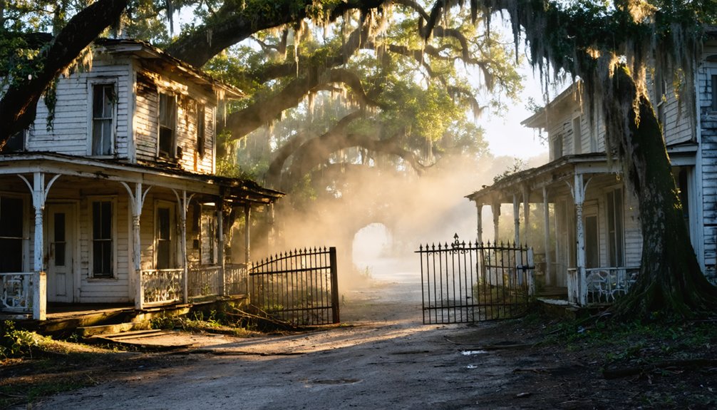
What Remains: Foundations, Cemeteries, and Spring-House Ruins
The skeletal remains of abandoned hot spring communities tell their stories through cracked concrete foundations, weathered gravestones, and crumbling bathhouse structures.
You’ll discover foundational remnants that reveal the layout of resort complexes that once promised healing waters to visitors seeking relief. At Pinnacle Springs in Arkansas, you can trace the outline of hotels and bathhouses from the 1880s era.
When you’re exploring these sites, you’ll encounter:
- Stone foundations marking bathhouse locations where thermal waters once flowed
- Intact cemetery plots with markers identifying resort owners and long-term residents
- Collapsed spring-house structures with visible pipe systems
- Deteriorating wooden boardwalks connecting treatment facilities
Your cemetery explorations often reveal the most compelling narratives—tombstones documenting families who built their livelihoods around these thermal attractions before economic shifts forced abandonment.
Visiting Ghost Towns Today: Access, Preservation, and Safety

When planning your visit to abandoned hot spring communities, you’ll need to research current land ownership and access restrictions before setting out. Many Deep South ghost towns sit on private property, requiring permission from landowners.
Exploring ghost towns near Hot Springs can offer a unique glimpse into history, but it’s essential to tread carefully. In addition to understanding land ownership and access rights, be sure to consider the environmental impact of your visit. With a little preparation, you can uncover the stories behind these forgotten places while respecting the landscape.
Some sites are managed by historical societies with designated visiting hours, while others remain completely off-limits due to structural hazards or environmental concerns.
Ghost town preservation efforts vary considerably across the region. You’ll find some locations with marked trails and informational signage, while others lack any protective measures.
Safety regulations aren’t always posted, so you’re responsible for evaluating risks yourself. Watch for unstable foundations, contaminated spring water, and overgrown terrain.
Always bring proper footwear, inform someone of your location, and respect any posted boundaries to protect both yourself and these irreplaceable historical sites.
Mapping Your Journey: Coordinates and Nearby Hot Springs Destinations
Once you’ve assessed access and safety considerations, plot your route using GPS coordinates to navigate Arkansas’s backcountry roads where signage often disappears.
Start at Hot Springs (34.503°N, 93.055°W) and venture to settlements where ghost town legends and mineral water myths still echo through abandoned foundations.
Your ghost-town circuit:
- Graysonia (34.157°N, 93.256°W) – lumber-boom remnants 40 miles southwest
- Pinnacle Springs (Faulkner County) – 13 springs, bathhouses, and college ruins along North Cadron Creek between Damascus and Guy
- Daleville site near Arkadelphia – mill foundations within 50 miles
- Rush (36.128°N, 92.571°W) – Buffalo River mining ghost for northern extension routes
Download offline maps before departing.
Cell service vanishes quickly beyond paved highways, and private-property boundaries shift without posted warnings.
Frequently Asked Questions
Can I Legally Collect Artifacts From Abandoned Deep South Ghost Town Sites?
You can’t legally collect artifacts without permission. Legal regulations on federal, state, and private lands prohibit removal to guarantee artifact preservation. Even “abandoned” sites remain protected—ownership and cultural-resource laws still apply everywhere.
Which Ghost Towns Near Hot Springs Offer Accessible Camping or Overnight Stays?
Like nomads seeking lost oasis springs, you’ll find camping options scarce at ghost sites themselves. Tyler Bend campground near Rush offers overnight facilities, while Calico Rock riverside parks provide bases for Peppersauce exploration—freedom demands approved sites.
Are Any Deep South Ghost Town Springs Still Thermally Active Today?
No Deep South ghost town springs remain thermally active today. You’ll find only cold mineral springs like Clementia’s earthquake-born flow in South Carolina—historically significant for their healing reputation, but they’ve never produced geothermal heat.
What Medical Conditions Were Visitors Claiming to Cure at These Springs?
Chasing miracle cures, you’d have soaked for rheumatism, arthritis, syphilis, “bad blood,” skin diseases, and paralysis. These historical treatments promised health benefits through thermal bathing, though most claims lacked scientific proof beyond temporary relief.
How Do I Identify Original Spring Sources at Overgrown Resort Sites?
Look for persistent baseflow, travertine deposits, and remnant springhouses on old USGS maps. Spring identification techniques like tracking wet spots and foundations during overgrown site exploration reveal original vents where resort structures once clustered.
References
- https://arkansasfrontier.com/ghost-towns-in-arkansas/303766/
- http://freepages.rootsweb.com/~gtusa/history/usa/ar.htm
- https://aymag.com/arkansas-backstories-ghost-towns/
- https://www.youtube.com/watch?v=s2a3hAf5d-Y
- https://onlyinark.com/places-and-travel/rush-arkansas-ghost-town/
- https://www.youtube.com/watch?v=U4kJjjbcnMM
- https://en.wikipedia.org/wiki/List_of_ghost_towns_in_Arkansas
- https://www.youtube.com/watch?v=ToQlvasj_ow
- https://www.geology.arkansas.gov/geology/stratigraphic-summary-of-the-arkansas-river-valley-and-ouachita-mountains.html
- https://gotbooks.miracosta.edu/geology/regions/ouachita_orogenic_belt.html


