You’ll find Rush, Arkansas’s best-preserved zinc mining ghost town, just 90 minutes northeast of Hot Springs along the Buffalo National River, where a 4-mile interpretive loop connects mill ruins, an 1886 stone smelter, and worker housing from its 1916 peak of 5,000 residents. Closer to Hot Springs, vanished spa communities like Pinnacle Springs and Magnesia Springs once featured bathhouses and mineral water resorts before railroad shifts and highway realignments caused their abandonment. The sections below trace how single-resource economies created—and destroyed—these Ozark settlements.
Key Takeaways
- Pinnacle Springs, discovered in 1880, featured twelve bathhouses and Arkansas Christian College before declining into scattered foundations.
- Magnesia Springs near Hot Springs offered magnesium-rich bottled water and boarding houses before fading into obscurity.
- Happy Hollow and Whittington Park operated as working-class bathing colonies serving Hot Springs before their eventual decline.
- Smaller communities like Shady Grove emerged around minor mineral springs but disappeared as state parks centralized recreation.
- Highway realignments and the shift from rail to automobile travel caused economic downturns in spa resort towns.
Rush: Arkansas’s Best-Preserved Mining Ghost Town on the Buffalo River
In the early 1880s, prospectors descended upon Rush Creek in search of silver deposits inspired by Indian legends, only to discover that the shiny metallic flakes weren’t precious metal at all—they’d found zinc ore instead.
Despite this initial disappointment, Rush history transformed dramatically as the mining boom attracted thousands. By 1916, Rush claimed the title of Arkansas’s most prosperous city per capita, with nearly 5,000 residents supporting its mining heritage during World War I’s peak demand.
At its zenith in 1916, Rush stood as Arkansas’s wealthiest city per capita with nearly 5,000 residents riding the wartime zinc boom.
The collapse came swiftly when zinc prices plummeted after the war ended, and imported zinc undercut local production. The town was officially declared a ghost town in 1972 when it became part of the national park system. The Rush Historic District was added to the National Register of Historic Places in 1987.
Today, you’ll find Rush preserved within Buffalo National River’s boundaries, where a four-mile trail guides you past accessible mine shafts and remnants of this once-thriving community.
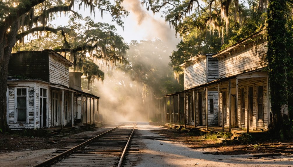
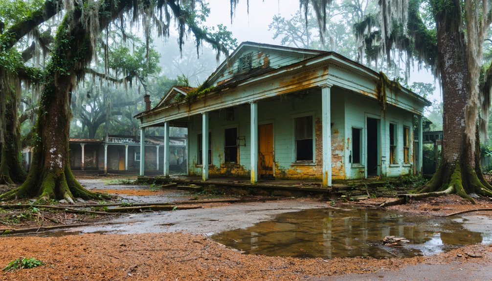
Pinnacle Springs: The Lost Spa Community of Faulkner County
While Rush built its fortune on zinc mining, another Arkansas community staked its future on an entirely different natural resource.
The springs discovery in 1880 by cattle herder Jeff Collier sparked immediate resort development when James Martin and businessmen formed the Pinnacle Springs Land Company in 1881.
You’ll find this Faulkner County location promoted therapeutic waters through thirteen springs, attracting visitors to the forty-room Pinnacle House and Park House hotels.
By 1886, the community featured twelve bathhouses, eight stores, and Arkansas Christian College.
The college’s first and only class graduated in June 1890 before the institution permanently closed.
However, the town’s reputation collapsed when waters proved medically ineffective and “immoral” elements arrived.
The post office closed in 1891, and residents scattered to Guy and Damascus.
Today, only scattered foundations remain along North Cadron Creek. Like other Arkansas ghost towns, Pinnacle Springs has minimal physical evidence of its once-thriving existence.
How Mineral Waters Built and Abandoned Southern Resort Towns
Across the American South, mineral springs transformed rural crossroads into bustling resort economies that rivaled established cities in visitor traffic and commercial activity.
You’ll find that Mineral Wells, Texas, with just 8,000 residents, welcomed 150,000 annual visitors by the early 1900s—a ratio that supported massive resort infrastructure including pavilions, bathhouses, grand hotels, and bottling plants.
Railroads created these boom towns overnight, delivering health-seekers directly to promenades and sulfur pools.
But that same dependence proved fatal. When rail lines shifted routes or automobile highways bypassed aging spa districts, economic decline followed swiftly.
Communities like Sexton, Arkansas, vanished after losing their railroad connection.
The medical establishment’s embrace of germ theory and antibiotics further eroded faith in balneology, hastening the collapse of resorts built entirely on therapeutic water claims.
Promoters had made sweeping claims that mineral waters cured ailments ranging from rheumatism and tuberculosis to jaundice and cancer.
What remains today are shuttered hotels and crumbling bathhouses—architectural monuments to therapeutic waters that once sustained entire regional economies.
Railroad Routes and Highway Shifts That Created Ozark Ghost Towns
You’ll find that the Frisco main line‘s arrival in Fayetteville in 1881 sparked a railroad-building boom across the Ozarks, with branches like the White River line to Chadwick (1882–1883) creating shipping towns such as Sparta, Oldfield, and McCracken at every new depot.
When these same rail spurs were abandoned—the Kissick-to-Ozark segment vanished in 1983, portions of the High Line as early as 1908—communities that depended on freight service lost their economic base and emptied into ghost towns.
Highway realignments dealt similar blows: Route 66‘s 1926 path brought prosperity to Halltown, Spencer, and Avilla, yet later upgrades and interstate construction diverted traffic away from those main streets, leaving gas stations and cafes standing empty along what became known as the “ghost town stretch.”
The K.C.C. & S. Railroad, built in the 1890s to compete with Frisco, created its own network of settlements before being acquired by Frisco in 1902, rendering many of its routes redundant and obsolete. Engineers on the declining Chadwick line occasionally stopped trains for blackberry picking and quail shooting as business dwindled in the years before the 1934 abandonment.
Rail Lines Fueled Growth
When the St. Louis–San Francisco Railway pushed into the Ozarks in 1881, you witnessed railroad impact that transformed isolated valleys into commercial nodes overnight.
The Frisco received 12,800 acres per mile of Arkansas track, selling parcels that anchored new farmsteads directly to depots. Town development clustered around sidings—Sparta was platted June 17, 1885, becoming a lumber shipping hub on the White River Branch.
Timber extraction drove specialized feeder lines like the Chadwick Branch, where McCracken and Oldfield existed solely as rail stops. The Eureka Springs Railway (1880) elevated a remote hollow into a spa boomtown by linking Seligman, Missouri.
You saw single-industry towns—sawmill camps, mining spurs—rise rapidly, their commercial districts hugging depot platforms and loading zones where timber and ties fueled Ozark economies.
Automobile Era Bypassed Towns
The steel rails that built Ozark prosperity also guaranteed its fragility. When automobile impacts reshaped American travel patterns, your once-thriving spring resorts faced extinction.
Pinnacle Springs, Arkansas lost visitors after highway improvements bypassed Cadron Creek’s mineral baths entirely. Monarch Spring, Missouri never recovered from 1920s flood damage—new auto routes simply erased it from travelers’ maps.
You’ll find Avilla, Missouri stripped of merchants after both railroad and highway corridors shifted away. Halltown thrived on Route 66‘s steady stream until Interstate 44 diverted that river of commerce.
The tourism decline proved irreversible: bathhouses burned, hotels shuttered, and commercial blocks emptied. Towns that invested heavily in garages and motor courts for trail traffic watched their economies collapse when straightened highways delivered speed-hungry motorists past their doorsteps without a single stop.
Single-Resource Economies: From Zinc Booms to Timber Busts
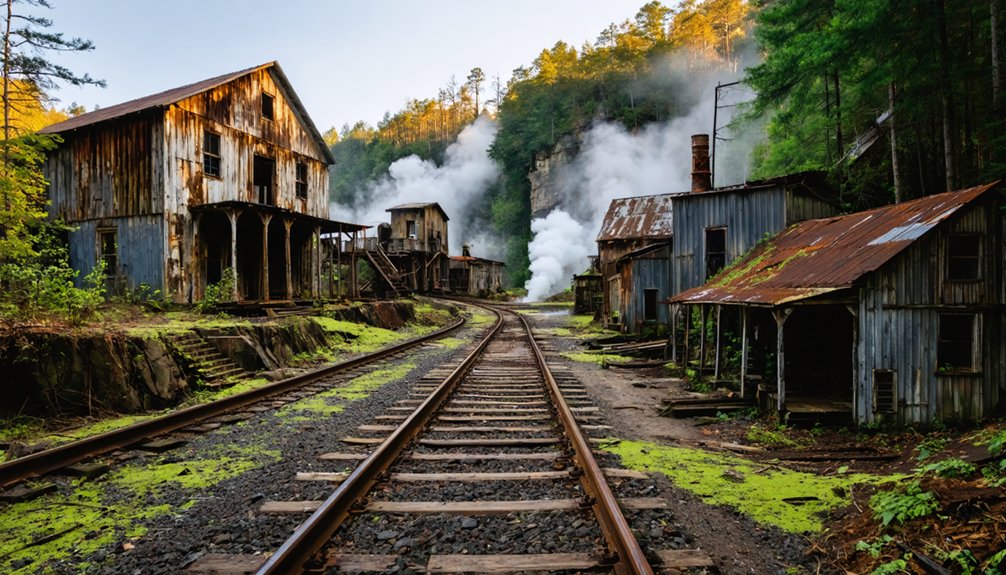
Along the Buffalo River’s limestone bluffs, Rush, Arkansas exemplified the volatile fortunes of single-resource extraction towns that dotted the Ozark and southern highland regions.
Beginning around 1880, Morning Star and other zinc mines drove Rush’s growth, culminating in a 13,000-pound boulder displayed at the 1893 Chicago World’s Fair. World War I’s zinc scarcity triggered frenzied expansion, with around-the-clock operations and dense worker housing.
Post-war collapse shuttered mines, businesses failed, and residents fled. By 1972, Rush became a ghost town.
Similarly, southern timber towns built around short-lived sawmills exhausted nearby forests within two decades, creating economic catastrophe.
Timber sustainability never factored into planning—clear-cutting yielded stranded company housing, abandoned rail spurs, and derelict infrastructure.
Without alternative employment, these single-industry settlements couldn’t survive market shifts or resource depletion.
Exploring Rush Today: Trails, Ruins, and Visitor Information
You’ll find Rush’s primary interpretive route—a roughly 4-mile loop combining trail segments and historic road grades—passes most standing buildings, mine sites, and prominent ruins dating from 1880 to 1940.
The Morning Star Hotel and Mill ruins anchor the western portion of the district, while the 1886 stone smelter, recognized as Rush’s oldest structure, remains visible near conspicuous white tailings hills left by room-and-pillar mining operations.
Though interpretive signage and self-guided materials encourage exploration of this National Register–listed ghost town, the National Park Service strictly prohibits entering mine openings and requires you to stay off all standing buildings and fenced ruins due to collapse hazards and structural instability.
Morning Star Loop Trail
A quarter-mile gravel loop through forested Ozark terrain, the Morning Star Interpretive Loop Trail encircles remnants of Rush’s most visible zinc mining operations within the Buffalo National River‘s Rush Historic District.
You’ll complete the circuit in fifteen to thirty minutes, following interpretive panels that decode the industrial landscape—smelter foundations, building sites, and fenced mine entrances tucked into hillsides. The trail features short, steep sections but remains accessible for most visitors, connecting at its upper end to the 1.5-mile Mine Level Trail for extended exploration.
Reach the trailhead by driving ten miles south from Yellville on Highway 14, then five miles west on County Road 6035 to a small gravel lot.
No activity fee applies, though Buffalo National River entrance policies govern access to this self-guided journey through zinc-boom history.
Historic Building Access Rules
Federal preservation law protects Rush’s standing buildings, foundations, and mine structures as cultural resources within Buffalo National River, prohibiting visitors from entering, climbing on, or removing artifacts from any historic feature.
You’ll find on-site signage instructing you to view structures from a distance, with mine openings gated against entry due to collapse hazards and toxic atmospheres. While you’re free to walk among ruins where designated paths exist, closed or unstable areas may carry citations under NPS regulations.
Historic preservation requirements forbid touching walls, collecting metal fragments or bottles, and defacing surfaces with graffiti or carvings. These visitor guidelines reflect Rush’s National Register listing, which mandates protection of the district’s 1,300-acre historic landscape while maintaining your access to interpretive trails and viewing areas.
Other Forgotten Communities in the Hot Springs Region
Beyond the well-documented mining camps and railroad depots, Hot Springs’ gravitational pull as a health resort created an entire constellation of satellite communities that have since faded into obscurity.
You’ll find remnants of Magnesia Springs east of town, where entrepreneurs bottled magnesium-rich water and operated boarding houses through the early 1900s.
Happy Hollow and Whittington Park once housed working-class bathers in dense cabin colonies before modern development erased them.
Smaller forgotten communities like “Shady Grove” clustered around minor mineral springs but couldn’t compete once automobiles made central bathhouses accessible.
Lake Catherine’s transient fishing camps and roadside spring stops along AR-7 and AR-70 similarly declined when state parks centralized recreation and interstate highways rerouted traffic, leaving these once-thriving health outposts abandoned.
Frequently Asked Questions
Are Any of the Mineral Springs Near Ghost Towns Still Accessible to Visitors?
Mineral springs accessibility near Southern ghost towns is severely limited; you’ll find most sites on private land without formal visitor infrastructure. Ghost town tourism in the region focuses on mining history rather than functional springs for bathing.
Can You Drink the Water From Historic Springs at Abandoned Spa Sites?
You shouldn’t drink historic spring water—it’s not Instagram-worthy when contaminated. Abandoned spa sites lack water quality monitoring, disinfection, and maintenance. Despite their historical significance, stagnant pools harbor Legionella, metals, and pathogens requiring modern treatment.
What Safety Precautions Should Visitors Take When Exploring Southern Ghost Towns?
Wear sturdy safety gear including boots, gloves, and eye protection; watch for local wildlife like snakes and scorpions in debris; test floors before walking; carry water; download offline maps; and respect property boundaries and posted warnings.
Are There Guided Tours Available for Ghost Towns Near Hot Springs?
Ironically, “ghost” towns thrive through guided tour options. You’ll find local tour operators near Southern hot springs offering heritage walks, mining-history excursions, and combination experiences—though access depends on land status, seasonal roads, and preservation regulations affecting your exploration freedom.
Explorers can discover unique ghost towns near hot springs, each filled with tales of the past and stunning natural beauty. These locations not only offer a glimpse into history but also provide the perfect backdrop for relaxing after a day of adventure. Whether you’re interested in the stories of former inhabitants or just want to soak in the nearby springs, there’s a wealth of experiences waiting to be uncovered.
Which Ghost Town Is Closest to Hot Springs National Park by Car?
Booger Hollow Outpost in Pope County is the closest ghost town to Hot Springs National Park by car. You’ll drive approximately 85-95 miles via AR-7 North—roughly 2-2.5 hours through the Ouachitas, exploring authentic ghost town history along scenic driving routes.
The ghost towns of the deep south offer a glimpse into the past, showcasing the remnants of once-thriving communities. As you explore these forgotten places, you’ll encounter intriguing stories and unique architecture that tell the tale of their rise and fall. Each site is a reminder of the region’s rich cultural history waiting to be discovered.
References
- https://aymag.com/arkansas-backstories-ghost-towns/
- https://onlyinark.com/places-and-travel/rush-arkansas-ghost-town/
- https://www.youtube.com/watch?v=ToQlvasj_ow
- https://www.uaex.uada.edu/environment-nature/musings-on-nature-blog/posts/ghost-towns.aspx
- https://www.tripadvisor.com/Attractions-g28925-Activities-c47-t14-Arkansas.html
- https://en.wikipedia.org/wiki/List_of_ghost_towns_in_Arkansas
- https://www.atlasobscura.com/places/rush-ghost-town
- https://encyclopediaofarkansas.net/entries/rush-ghost-town-marion-county-1270/
- https://buffaloriver.org/outdoor-adventure/ghost-town-rush-ar/
- https://www.barefoottraveler.com/rush.html


