
You’ll find Colorado’s best ghost town-hot springs combinations in the San Juan Mountains, where volcanic geology creates both mineral deposits and geothermal activity. Dunton Hot Springs offers restored 1885 cabins with private soaking at 107 degrees, while Animas Forks’ dozen preserved structures sit near Ouray’s developed springs. St. Elmo, at 9,961 feet, pairs early-1900s storefronts with nearby Mount Princeton Hot Springs. Red Mountain Pass crosses at 11,018 feet between ruins and thermal features, though snow closes high-elevation sites November through May. Understanding seasonal access and the mining-geology connection helps you plan successful explorations.
Key Takeaways
- Dunton Hot Springs combines a restored 1885 mining camp with luxury cabins and private 107-degree natural hot spring soaking year-round.
- Red Mountain Pass features dramatic mining ruins and access to thermal features, with volcanic forces heating both historic operations and groundwater.
- St. Elmo ghost town sits twenty miles from Mount Princeton Hot Springs, offering preserved 1900s structures at 9,961 feet elevation.
- Creede’s Bachelor Loop auto tour showcases ghost camps near Wagon Wheel Gap hot springs, accessible after exploring the historic mining district.
- Ouray hot springs provide developed thermal soaking near Silverton caldera ghost towns, with lesser-known local spots along the pass.
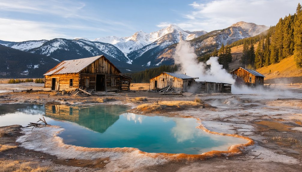
Dunton Hot Springs: A Restored Mining Ghost Town Experience
Dunton Hot Springs sits in a remote alpine valley of Colorado’s San Juan Mountains, where a once-thriving mining camp has been meticulously transformed into an exclusive luxury resort. Established in 1885 along the West Dolores River, this settlement peaked at 300 residents before mining decline left it deserted by 1918.
You’ll find Dunton history preserved in hand-hewn log cabins that now house contemporary interiors and modern amenities. The original saloon serves as the communal dining space, while the Well House cabin offers private hot spring soaking fed directly from geothermal vents. The natural hot spring maintains a consistent temperature of 107 degrees year-round.
Luxury accommodations range from the historic Bjoerkmans cabin—the town’s oldest surviving structure—to restored miners’ quarters, each blending authentic 1800s architecture with high-speed internet and premium comfort for travelers seeking authentic wilderness escape. The springs emerge from red sandstone and shale bedrock positioned along an ancient geological fault line at an elevation of 8,921 feet.
The San Juan Mountain Corridor: Where Ghost Towns Meet Geothermal Waters
Between Ouray’s vapor caves and Silverton’s historic spa district, the San Juan Mountain corridor preserves one of North America’s densest concentrations of high-alpine ghost towns, where mineral-rich geothermal features first drew prospectors who discovered far greater wealth in gold and silver veins.
You’ll find Alta’s intact cabins at 11,800 feet, offering exceptional ghost town photography against snowcapped peaks. Ten miles from Telluride, this unincorporated camp housed 100 miners before WWII revived strategic metal extraction.
Drive the Million Dollar Highway to Ironton, where 300 buildings materialized in three weeks during 1883. Red Mountain Town once supported 10,000 residents and 100 businesses—now dispersed foundations illustrate historical mining techniques across oxidized slopes.
Nearby Animas Forks features nine restored buildings, established in the late 1870s with a peak population of over 400 residents before harsh winters and declining mines forced its abandonment. Similar to Baja California’s Las Flores, where a 20 stamp mill processed ore at industrial scale, these San Juan operations employed advanced milling technology to maximize precious metal extraction.
The 65-mile Alpine Loop connects these sites, letting you soak in geothermal pools then explore shaft houses and tram towers without permits or fees.
Animas Forks and High-Altitude Ruins Near Ouray’s Springs
At 11,200 feet in the San Juan Mountains, Animas Forks stands as one of Colorado’s highest major ghost towns, positioned 12 miles northeast of Silverton along the Alpine Loop Backcountry Byway that connects back to Ouray’s hot springs.
Animas Forks history begins with its 1873 founding at the confluence of three river branches, growing to 450 residents by 1883 who supported mining operations like the Gold Prince Mill. The 1884 blizzard‘s 25 feet of snow forced residents to tunnel between buildings.
By 1883, this remote mining camp housed 450 hardy souls who tunneled through 25-foot snowdrifts to survive brutal mountain winters.
Among alpine ghost towns, it’s exceptionally preserved—BLM oversight protects about a dozen standing structures including the distinctive two-story Duncan House. The town once supported a hotel, saloons, a drug store, a post office, and a jail at its peak. By 1876, the settlement had grown to include 30 cabins, a general store, and the Animas Forks Pioneer newspaper that would later document local events.
You’ll find ruins of mills, saloons, and processing facilities scattered across this above-treeline basin, accessible summer through early fall when snow permits passage.
St. Elmo: Colorado’s Best-Preserved Ghost Town in the Arkansas Valley
While Animas Forks rewards adventurous drivers with high-altitude ruins, Colorado’s most accessible and intact ghost town sits in a different mountain range entirely.
Twenty miles southwest of Buena Vista, St. Elmo sprawls along Chalk Creek at 9,961 feet in the Sawatch Range. You’ll drive the old railroad grade from Nathrop directly to false-front storefronts that haven’t changed since miners abandoned them in 1922.
St. Elmo history unfolds through preserved saloons, hotels, and the general store where the Stark family maintained operations for decades.
Their tax-sale purchases during the 1920s decline kept structures standing when other camps crumbled. Stark family legends persist—locals report Annabelle’s ghost slamming doors in vacant buildings.
The town earned placement on the National Register of Historic Places in 1979, cementing its status as one of Colorado’s most significant mining heritage sites.
You’ll find Mount Princeton Hot Springs just up-canyon, pairing soaking pools with authentic mining-town exploration. Main Street offers a nostalgic stroll past 43 original structures, including hotels and a blacksmith shop that survived a 2002 fire.
Red Mountain Pass: Historic Mines Between Ouray and Silverton
You’ll find some of Colorado’s most dramatic mining ruins along the Million Dollar Highway between Ouray and Silverton, where Red Mountain Pass crosses 11,018 feet through a landscape still scarred by the 1880s silver boom.
The district’s vertical ore chimneys produced roughly $30 million in historic dollars from mines like the Yankee Girl and National Belle, leaving behind weathered headframes, collapsed mill buildings, and extensive tailings that you can spot from the highway. Comprehensive environmental restoration has been conducted throughout the district in recent years, improving ecological conditions while preserving the area’s mining heritage.
While Ouray’s hot springs lie just 12 miles north of the pass, winter avalanche danger and summer rockfall make this route impassable or hazardous during much of the year, so you’ll need to time your visit carefully between late spring and early fall. The pass divides the Uncompahgre and San Juan National Forests, with the highway maintaining an entirely paved surface despite its narrow width and lack of shoulders.
Mining Ruins and Infrastructure
Between Ouray and Silverton, the Red Mountain Mining District sprawls across one of Colorado’s most dramatic alpine landscapes, where iron-oxide-stained peaks tower over U.S. Highway 550.
You’ll encounter headframes, ore bins, and tram towers dotting the slopes—remnants of mines like Yankee Girl and National Belle that extracted $30 million in silver, gold, lead, and copper between 1882 and 1893.
The mining techniques evolved from early hand-drilling in rich vertical “pipe” ore bodies to large-scale operations under the Idarado Mine complex, which ran until the 1970s.
Ore processing infrastructure remains visible throughout: rusted tramways once carried ore down mountainsides to mills in valleys below, while waste dumps cascade down steep terrain.
Stop at interpretive pullouts along the Million Dollar Highway for unobstructed views of this industrial archeological landscape.
Geothermal Access Points Nearby
Though the Red Mountain district’s mines extracted millions in precious metals, the same volcanic forces that created those ore bodies continue to heat groundwater deep beneath the pass today.
You’ll find the Silverton caldera’s ring fractures—the same structures that guided historical mining operations—now channel thermal fluids upward from depths exceeding 1,000 feet.
Ouray’s developed hot springs represent the most accessible discharge point, fed by fault-controlled flow systems along the northern flank.
A lesser-known soaking spot exists off the pass itself, used quietly by locals who understand the terrain.
Colorado Geological Survey flags this volcanic center for future geothermal exploration, recognizing that the breccia pipes and alteration zones mapped during the mining era reveal today’s subsurface heat pathways.
Seasonal Road Conditions
Red Mountain Pass operates under some of Colorado’s most stringent winter driving conditions, with US Highway 550’s 12,000-foot summit section between Ouray and Silverton regularly facing closure from November through May.
You’ll need serious winter preparedness before attempting this route during storm season.
Before you head out, check these critical conditions:
- Heavy snow accumulation between 4-9 inches with 35 mph wind gusts creates whiteout potential
- Critical maintenance operations temporarily close the pass without warning
- COtrip’s real-time monitoring system provides current road status and traffic incidents
- Chain requirements remain mandatory regardless of current weather
- Seasonal closures depend on snowpack and avalanche risk assessments
You can’t wing it on Red Mountain Pass.
Monitor forecasts, carry chains, and don’t hesitate to postpone when conditions deteriorate.
Creede Area Ghost Camps and San Luis Valley Hot Springs
About 20 miles southwest of Creede, the Bachelor Loop auto tour forms a 17-mile driving route through the historic Creede mining district, where you’ll pass multiple ghost sites including Bachelor City, North Creede, Amethyst, and Weaver.
The district exploded after Nicholas Creede’s 1890 Holy Moses Mine silver discovery, swelling to 10,000 residents by the early 1890s. Today, Mineral County holds just 850 full-time residents.
Ghost town exploration reveals North Creede’s old jail and scattered cabin remnants at Bachelor, while Stumptown and Weaver have vanished entirely.
Creede history includes notorious outlaws like “Soapy” Smith and Bob Ford, Jesse James’s killer, who ran saloons until Ford’s 1892 murder.
After exploring these remote camps on Rio Grande National Forest lands, you can soak at nearby Wagon Wheel Gap hot springs in the San Luis Valley’s geothermal corridor.
Front Range Ghost Sites Near Northern Colorado Thermal Areas
You’ll find Arrow and the historic Rollins Pass railway grade positioned along the Continental Divide west of Nederland, where summer access connects you to remnants of this engineering marvel that once transported timber and passengers across the mountains.
Lulu City sits deeper in Rocky Mountain National Park territory, requiring a moderate 7.4-mile round-trip hike from the Colorado River Trailhead to reach the scattered foundations of this 1880s mining camp.
These Front Range sites demand careful timing since snow closes mountain roads from October through late June, and you won’t reach either location during Colorado’s harsh winter months without snowshoes or backcountry ski equipment.
Arrow and Rollins Pass
High above Winter Park’s ski runs, the forgotten railroad town of Arrow clings to the west slope of Rollins Pass at roughly 9,500 feet, tucked into dense subalpine forest along the abandoned Denver & Salt Lake grade.
This Arrow history diverges from typical mining camp narratives—it thrived as a lumber and railroad division point serving construction crews pushing westward toward Middle Park’s thermal valleys.
The 1920 fire and 1928 Moffat Tunnel opening sealed Arrow’s fate:
- Peak population exceeded 1,000 railroad workers and loggers
- Catastrophic fire destroyed most structures around 1920
- Moffat Tunnel diverted all rail traffic by 1928
- Tracks over Rollins Pass lifted by 1936
- Winter Park later annexed the 688-acre townsite
You’ll find scattered timbers, forest graves, and archived incorporation documents—but reaching this high-clearance ghost requires seasonal timing and determination.
Lulu City Hiking Access
While most Colorado ghost towns require rugged four-wheel-drive roads or bushwhacking cross-country routes, Lulu City offers a rare combination—a well-maintained trail through Rocky Mountain National Park leading to authentic 1880s mining ruins just upstream from the headwaters of the Colorado River.
You’ll find the Colorado River Trailhead 9.3 miles north of Grand Lake’s entrance station, where hiking trails begin along wide, flat terrain following the river valley. The 7.5-mile round-trip hike gains just 300-800 feet elevation, making it accessible for most fitness levels.
At 3.5 miles, you’ll turn left onto a spur trail descending to scattered cabin foundations, crumbling logs, and iron fragments—all that remains of a town that housed 500 prospectors before economic realities forced abandonment by 1883.
Seasonal Road Conditions Matter
Most sites above 9,000 feet face closure from October through May because of:
- Compacted snow and black ice on canyon approaches from Fort Collins, Estes Park, and Granby
- Avalanche paths crossing unmaintained mining roads
- Chain laws and plow-priority systems that bypass historic spurs
- Deep ruts and washboards during snowmelt on gravel routes
- Once-yearly road maintenance schedules that can’t keep pace with monsoon damage
High-clearance vehicles become necessary, not optional.
Emergency response times stretch dangerously long on remote ghost-town roads, making winter breakdowns genuinely consequential.
Mining Booms, Silver Busts, and the Geology of Hot Springs
Beneath the mineral-rich peaks of the Rocky Mountains, superheated groundwater has carved pathways through fault lines and fractured bedrock for millions of years, creating the hot springs that would later draw fortune seekers to remote valleys.
You’ll find these thermal waters rising through the same geological fractures that concentrated precious metals like silver and gold.
Mining legacies scattered throughout these ranges tell stories of prospectors who discovered ore veins near steaming pools, establishing camps that boomed into towns almost overnight.
Economic fluctuations tied to silver prices determined whether these settlements thrived or died.
When markets crashed, miners abandoned their claims, leaving behind empty structures beside the same hot springs that initially promised prosperity.
The geology that created wealth also marked its eventual demise.
Seasonal Access and 4×4 Requirements for Mountain Ghost Towns

When you plan a visit to Colorado’s mountain ghost towns, the elevation of your destination will determine not only which vehicle you need but also which months you can realistically make the trip.
Sites above 9,000 feet face serious seasonal challenges—snow closes passes into June, and early autumn blizzards shorten your window dramatically.
Smart access strategies start with checking current conditions:
Before heading up the mountain, verify road status, weather forecasts, and vehicle requirements to avoid getting stranded at elevation.
- Front-range towns: Often 2WD-friendly year-round on graded county roads
- High-elevation camps: Require high-clearance 4×4 for rocks, ruts, and creek crossings
- Summer-only routes: Independence Pass opens late May–early November, weather permitting
- Afternoon thunderstorms: Create flash floods and lightning hazards on exposed 4×4 tracks
- Forest Service closures: Protect wet roadbeds and wildlife during shoulder seasons
Standard vehicles simply can’t handle what altitude throws at you.
Preservation Efforts: From Private Resorts to Public Historic Sites
You’ll notice two distinct preservation philosophies when you visit ghost towns near hot springs: privately owned resorts like former bathhouse hotels use heritage branding and controlled access to fund stabilization, while public sites—many listed on the National Register—prioritize open access and resource protection through agencies like BLM and the Forest Service.
Hybrid models have emerged around Silverton and Aspen, pairing public land managers with nonprofits that raise funds and execute million-dollar projects such as the $1.5 million Shenandoah-Dives Mill restoration.
Whether you’re touring a curated ruin at a boutique resort or reading interpretive signage at Animas Forks, these approaches shape how fragile structures survive rising visitation and alpine weather.
Adaptive Reuse Resort Models
While many Rocky Mountain ghost towns crumble into irretrievable ruin, Dunton Hot Springs proves that private hospitality investment can resurrect these settlements as functioning communities.
This former 1880s mining camp in Colorado’s San Juan Mountains demonstrates how adaptive reuse transforms abandonment into economic significance while funding historic preservation.
The resort’s luxury pricing structure generates capital that abandoned sites rarely attract:
- Original log cabins stabilized and converted to guest accommodations with modern plumbing
- Hand-hewn logs and historic joinery preserved during interior upgrades
- Controlled access prevents vandalism and artifact theft plaguing unmonitored ghost towns
- Alpine valley maintained in natural condition with minimal new construction
- Multi-season programming (hiking, soaking, snow activities) sustains year-round operations
You’ll find historic fabric authentically retained while the site generates revenue replacing the extraction economy that originally built it.
Public Access Preservation Standards
Between abandoned private resorts and working luxury retreats lies a third model: publicly managed ghost towns where preservation standards must balance access against deterioration.
You’ll find sites like Animas Forks applying stabilization protocols—roof repairs, foundation bracing, wall reinforcement—funded through multi-phase grants exceeding $330,000. These standards follow the Secretary of the Interior’s guidelines: minimal intervention, reversible work, in-kind material replacement.
Public access here means designated trails and viewing platforms that channel foot traffic away from fragile structures. You can explore freely along marked routes, but entry into unstable buildings is restricted through fencing and boardwalks.
Management plans set visitor capacity limits and seasonal closures, protecting archaeological deposits while maintaining your freedom to experience authentic mining-era remains without total reconstruction or privatization.
Interpretive Programs and Signage
As ghost towns changed from private resort amenities to public historic sites, the signs themselves tell a story of shifting purpose. Early wayfinding markers at places like Dunton Hot Springs directed guests to spa amenities, while today’s interpretive signage foregrounds historical narratives—founding dates, boom-bust cycles, and the labor that built these communities.
You’ll notice standardized formats now:
- Federal land agencies (USFS, NPS) co-design panels blending cultural and natural-resource education
- Historical societies maintain interpretive trails under long-term permits on public land
- Exhibit-design firms produce durable signs with consistent typography and iconography
- Population figures and industry timelines replace resort branding
- Environmental context explains landscape recovery where only foundations remain
This shift grants you deeper access to authentic mountain heritage beyond commodified nostalgia.
Frequently Asked Questions
Can I Camp Overnight at Ghost Town Sites Near Hot Springs?
Camping regulations vary widely—some ghost towns allow dispersed camping nearby but not within historic structures, while others operate as private resorts with zero public access. You’ll find few ghost town amenities, so research each site’s specific rules before planning overnight stays.
Are Pets Allowed at Ghost Towns and Hot Springs Facilities?
Most Rocky Mountain ghost towns welcome leashed pets outdoors, but you’ll find hot springs facilities ban animals from pools due to health codes. Pet policies vary—seek out pet friendly accommodations at nearby lodges or campgrounds instead.
Do I Need Permits to Visit Ghost Towns in National Forests?
You typically don’t need permits for day hiking to ghost towns on national forest lands, but permit requirements apply if you’re camping overnight, conducting commercial activities, or when specific national forest regulations post restrictions at designated historic sites.
What Cellphone Coverage Exists Near Remote Ghost Towns and Hot Springs?
You’ll face severe coverage limitations near remote Rocky Mountain ghost towns and hot springs—expect little to no cell service in deep valleys and high passes. Plan offline maps, carry cash, and prepare satellite backup for emergencies.
Are Guided Ghost Town Tours Available From Hot Springs Resorts?
Yes, you’ll find guided tours from many Rocky Mountain hot springs resorts. Operators partner with jeep and ATV outfitters to deliver historical insights at sites like St. Elmo, Animas Forks, and Dunton, combining freedom with expert-led exploration.
References
- https://en.wikipedia.org/wiki/List_of_ghost_towns_in_Colorado
- https://www.visitouray.com/ghost-towns
- https://www.colorado.com/articles/colorado-ghost-towns
- https://www.mycoloradoparks.com/park/rocky-mountain-ghost-town-ruins/
- https://es.uchealth.org/today/ghost-towns-abound-in-colorado/
- https://www.uncovercolorado.com/ghost-towns/
- https://www.duntondestinations.com/hot-springs/
- https://www.tripadvisor.com/Attractions-g28927-Activities-c47-t14-Colorado.html
- https://www.beautifulnow.is/discover/travel/dunton-hot-springs-haunting-beauty
- https://www.denver7.com/lifestyle/discover-colorado/colorado-ghost-towns-dunton-transformed-from-mining-camp-into-luxury-dunton-hot-springs-resort


