You’ll discover remarkable ghost towns within two hours of Jackson Hole, each revealing Wyoming’s frontier past. Mormon Row Historic District, inside Grand Teton National Park, showcases iconic homestead barns against the Tetons—a photographer’s dream since 1908. South Pass City preserves over 40 original 1860s gold rush structures as a state historic site, while nearby Atlantic City blends abandoned mining buildings with a handful of persistent residents. These settlements illustrate the stark differences between Wyoming’s boom-and-bust mining camps and enduring agricultural communities, with detailed exploration revealing deeper preservation stories.
Key Takeaways
- Mormon Row Historic District in Grand Teton National Park features six building clusters from 27 homesteads established in 1908.
- South Pass City preserves over 40 original 1860s structures from Wyoming’s gold rush era with museum exhibits and tours.
- Atlantic City, a semi-ghost town twenty minutes from South Pass City, has abandoned buildings alongside functioning businesses and homes.
- South Pass City peaked at 2,000–3,000 residents between 1867–1869 before declining to under 100 by 1872.
- High-clearance 4WD vehicles, bear spray, and layered clothing are recommended for exploring ghost towns near Jackson Hole.
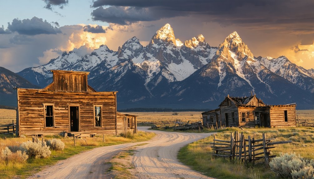
Mormon Row Historic District: Photogenic Homesteads in Grand Teton National Park
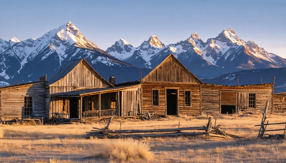
While most ghost towns evoke images of complete abandonment, Mormon Row Historic District represents a more nuanced form of decline—a once-thriving agricultural community reduced to photogenic ruins within Grand Teton National Park.
You’ll find approximately 27 homesteads established here beginning in 1908, when Mormon settlers transformed high-desert sagebrush into irrigated hayfields through an ambitious ditch system.
The T.A. Moulton and John Moulton barns now rank among America’s most photographed historic architecture, their weathered timber frames commanding foreground positions against the Teton Range.
Weathered timber barns frame the Tetons in compositions that have made Mormon Row among America’s most photographed historic landscapes.
The settlement’s linear arrangement along the Jackson-Moran road creates striking geometric patterns across meadows where cooperative farming once sustained this tight-knit Latter-day Saint community.
Today, six main building clusters remain—tangible evidence of late-frontier Mormon expansion.
The harsh realities of high-altitude farming meant that failed homesteads equaled or exceeded successful ones, revealing the difficulty of agricultural survival in this challenging environment.
The community earned recognition when it was added to the National Register of Historic Places in 1997, formally acknowledging its significance in homesteading history.
South Pass City: Gold Rush Ghost Town Turned State Historic Site
You’ll find Wyoming’s best-preserved gold rush settlement at South Pass City State Historic Site, where more than 40 original 1860s structures document the Carissa Mine’s boom-and-bust cycle.
The town exploded from frontier outpost to a community of 2,000–3,000 residents between 1867 and 1869, then collapsed just as rapidly when ore complexities and investor disputes idled operations.
By 1872, the population had fallen to below 100 residents in each of the South Pass towns, marking the end of the initial mining frenzy.
Today’s state historic site operates seasonally, offering you access to restored buildings, interpretive exhibits, and the imposing 1903 Carissa stamp mill that still dominates the gulch.
The stamp mill was relocated and restored in 1976, preserving the legacy of the miners who worked the surrounding claims like Palmetto Gulch.
Boom Years and Decline
Reality undermined the hype quickly. Narrow, discontinuous ore bodies frustrated long-term profitability. By April 1868, miners were already abandoning claims for strikes elsewhere.
The Carissa’s £115,000 sale to London investors collapsed mid-transaction, idling the district’s best producer. Easily worked placers exhausted by 1869, and population decline accelerated as merchants and families departed. The town had peaked at 1,517 in 1869 but fell to less than 100 by 1872.
What boosters claimed would be a city of 10,000 dwindled to a handful of persistent residents by the 1870s. The 1900 census documented the continued decline, reporting 142 residents in what had once been Wyoming’s second incorporated city.
Historic Buildings and Museum
South Pass City’s abandonment proved fortunate for preservation. When Wyoming purchased the townsite in 1966, it acquired 23–24 original structures largely intact.
Today you’ll explore one of the state’s largest historic sites, where meticulous historic preservation has restored buildings like the 1890 Carissa Saloon and 1896 Smith-Sherlock Store to their frontier-era appearance.
The site’s 30,000 artifact collections fill more than 30 period room exhibits, viewable through protective plexiglass. You’ll peer into furnished homes, shops, and workspaces that interpret daily life during the gold rush.
The restored Carissa Mine and Mill complex demonstrates industrial mining technology that defined South Pass’s boom years. The Carissa Mine’s discovery of a large vein triggered the town’s most significant growth period during the mining boom. Visitors can experience gold panning alongside guided tours of the historic mining operations.
National Register listing protects this authentic townscape, where collaboration between state agencies and private organizations guarantees accurate interpretation of Wyoming’s mining heritage.
Seasonal Access and Visiting
Admission runs approximately $8 general, with Wyoming resident discounts and free entry for visitors 17 and under. This fee includes a 90-minute guided tour of the Carissa Gold Mine, where knowledgeable historians share insights into historical mining operations and conditions. Visitors can explore the site using a self-guided walking tour with informational materials about the various historic buildings throughout town.
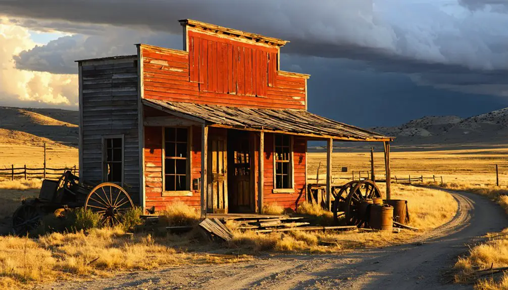
Atlantic City: Semi-Ghost Town Along the South Pass Scenic Byway
Perched along the eastern slope of the Wind River Range, Atlantic City emerged in 1868 as a rough-and-tumble mining camp during the Sweetwater Mining District’s gold rush.
Today you’ll find a true semi-ghost town where abandoned structures stand alongside occupied homes, preserving authentic mining heritage while maintaining a small residential community.
What makes Atlantic City unique:
- Dual character – boarded-up false-front buildings coexist with functioning businesses including a store and restaurant
- Historic fabric – wooden commercial structures, an old church, and scattered miners’ cabins dot unpaved streets
- Strategic location – twenty minutes from South Pass City along the scenic byway, forming a ghost-town triple feature
- High-elevation setting – sagebrush foothills offer sweeping Continental Divide views
You’ll experience informal self-guided exploration through this atmospheric outpost.
Planning Your Ghost Town Road Trip From Jackson Hole
Although Jackson Hole sits two to six hours from Wyoming’s most compelling ghost towns, its position at the gateway to Grand Teton and Yellowstone National Parks makes it an ideal base for multi-day heritage loops.
Jackson Hole’s strategic location between Grand Teton and Yellowstone makes it the perfect staging point for exploring Wyoming’s frontier history.
For road trip logistics, prioritize the Jackson → Mormon Row → Yellowstone south entrance → Cody/Meeteetse corridor, allowing 4.5–6 hours driving time to reach Kirwin or Old Trail Town.
Check Wyoming 511 and NPS road status pages before departure—interior park routes typically open late May through mid-October. Refuel at Jackson, Moran Junction, West Thumb, and Cody to avoid long service gaps.
For ghost town photography targeting Kirwin’s mining ruins or Mormon Row’s homestead cabins, pack high-clearance 4WD capability, bear spray, and layers for rapid mountain weather shifts.
Afternoon thunderstorms and unmarked mine shafts demand constant situational awareness.
Mining Booms vs. Agrarian Settlements: The Stories Behind Abandoned Wyoming Towns
Wyoming’s abandoned settlements tell two distinct stories: mining camps that exploded with thousands of residents during coal extraction booms before collapsing within decades, and agricultural communities like Mormon Row that developed gradually through homesteading families who worked the land.
You’ll find mining towns featured company-controlled infrastructure—bathhouses, miner’s halls, and organized labor housing—while agrarian settlements built family-owned homesteads, barns, and community churches that reflected permanent settlement intentions.
Understanding these contrasting development patterns reveals why some sites preserve scattered mining equipment and open pit hazards, while others showcase intact homestead cabins and irrigation systems that served multi-generational farming operations.
Gold Rush Cycles Explained
When Wyoming Territory‘s population swelled to 16,000 residents in 1868, the railroad brought more than iron rails—it delivered a generation of fortune seekers whose temporary camps would vanish as quickly as they appeared.
Gold rush impacts shaped Wyoming’s landscape through boom-and-bust cycles driven by resource extraction economics:
- “Hell on Wheels” settlements relocated every few months as railroad construction advanced westward.
- The Miners Delight Mining Company attempted revival in 1907, demonstrating persistent extraction hopes.
- Surface iron ore operations (1962-1983) temporarily revived abandoned settlements before economic realities forced closure.
- Depression-era squatters repopulated ghost town cabins during the 1930s when unemployment peaked.
Mining challenges included avalanches, isolation, and market volatility—forces that transformed thriving extraction sites into stranded infrastructure within decades.
Mormon Row’s Agricultural Legacy
The Mormon Row settlement tells a fundamentally different story than Wyoming’s extractive boom-and-bust camps—one rooted in permanent agricultural development rather than ephemeral resource raids.
You’ll find evidence of sustainable farming throughout this clustered homestead community, where hand-dug irrigation ditches and coordinated levee systems transformed arid land into productive fields between 1896 and 1937.
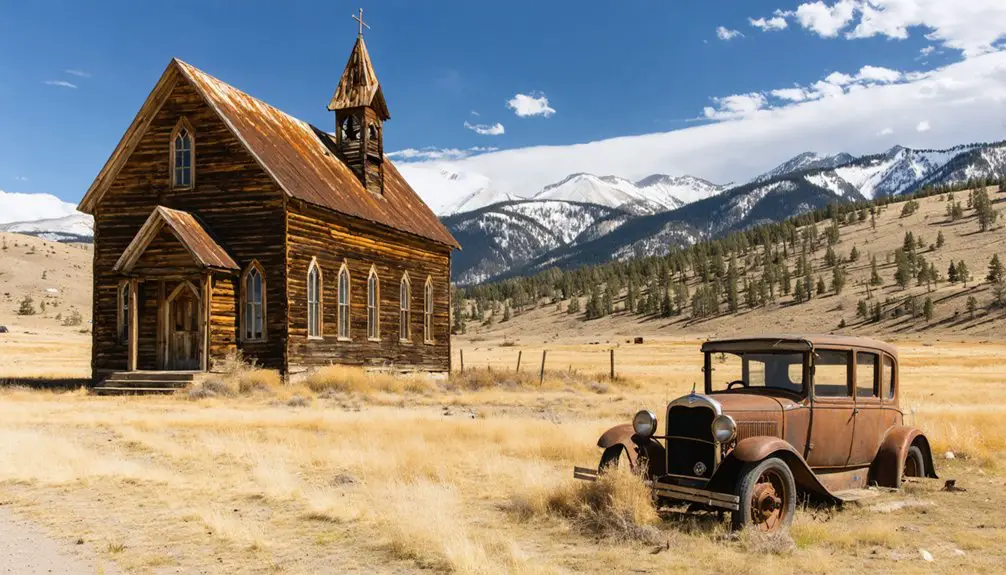
Unlike isolated frontier ranches, Mormon Row’s twenty-seven homesteads formed the village of Grovont, anchored by a church and school that fostered genuine community cooperation.
Families like the Moultons worked adjoining farms across generations, sharing labor and managing water collectively through sophisticated ditch networks.
They raised oats, barley, hay, and livestock—some even supplied the region’s only dairy operation.
This agrarian persistence, not mining speculation, shaped their ghost landscape.
Infrastructure Patterns Across Settlements
Where mineral extraction failed to take root, agriculture built differently—and you’ll recognize the distinction immediately by reading the land’s infrastructure scars. Mining infrastructure development left transient marks: eroded hillsides, collapsed tunnels, and wagon roads built for hauling coal from Cache Creek—routes requiring twenty days over Teton Pass.
Compare this to Mormon Row’s enduring barns and irrigation ditches.
Infrastructure patterns reveal settlement permanence:
- Mining booms constructed temporary facilities (Whetstone’s cabins, sluices, ferry) abandoned by 1897.
- Coal operations drove road construction but ceased by the mid-1930s, leaving access corridors later repurposed for recreation.
- Agricultural settlements invested in permanent structures—homes, barns, fencing—designed for generational occupation.
- Reclamation efforts beginning in 1942 closed mining roads, protecting Cache Creek’s water quality for municipal use.
You’re witnessing economic philosophies written in landscape architecture.
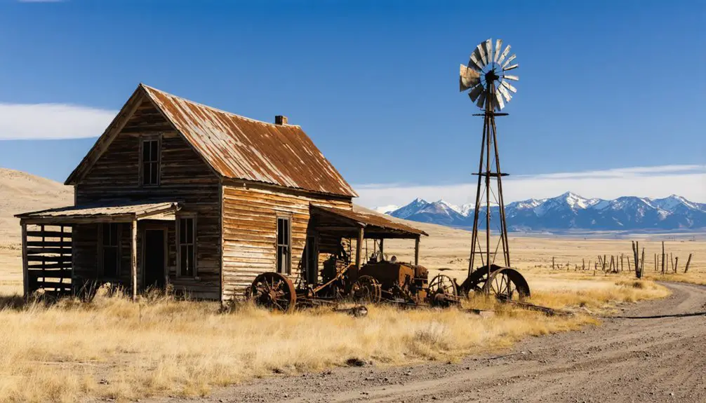
Additional Remote Ghost Towns Worth Exploring in Wyoming
Beyond Jackson Hole’s immediate vicinity, Wyoming’s vast landscapes harbor numerous remote ghost towns that reward adventurous explorers willing to venture onto backcountry roads and high-elevation trails.
Among these hidden gems are abandoned sites near Cody Wyoming, where the remnants of past lives can be found amidst wildflowers and sagebrush. Each location tells a story of a once-thriving community and invites curious minds to imagine its history. As you explore these forgotten places, the stunning backdrop of the Absaroka Mountains enhances the sense of adventure and discovery.
Other fascinating remnants can be found in abandoned sites around Kemmerer Wyoming, where wooden structures lean against the strength of time and nature slowly reclaims its territory. These locations, steeped in history, beckon visitors to uncover the secrets hidden within crumbling walls and overgrown landscapes. With each step, the echoes of the past resonate, creating a palpable connection to those who once called these places home.
Kirwin, nestled in the Absaroka Mountains near Meeteetse, offers exceptional remote exploration opportunities with 38 remaining buildings accessible only by four-wheel-drive. This 1890s gold and silver settlement housed 200 residents before avalanches and harsh winters forced abandonment.
Thirty-eight weathered structures stand testament to Kirwin’s brief prosperity, where 200 gold seekers once defied mountain winters before nature reclaimed the settlement.
South Pass City State Historic Site preserves 20+ original structures from its 2,000-miner heyday, representing Wyoming’s most significant gold district.
The Gebo-Crosby coal district north of Thermopolis showcases early-20th-century industrial heritage across expansive badlands terrain.
Carbon County’s Battle, Rambler, and Rudefeha settlements demonstrate the historical significance of high-country copper mining operations along the Continental Divide.
Frequently Asked Questions
Are Ghost Town Visits Near Jackson Hole Safe for Families With Children?
You’ll find family safety excellent at accessible sites like Mormon Row and South Pass City, where maintained pathways and preserved structures create enriching ghost town activities. Avoid remote Kirwin without proper vehicles and experience exploring challenging terrain.
Can I Camp Overnight at Mormon Row or South Pass City?
No, you can’t camp overnight at either site due to camping regulations. Mormon Row requires overnight permits only for designated backcountry zones, while South Pass City allows day-use only. Nearby public lands offer dispersed camping freedom.
What Months Offer the Best Weather for Ghost Town Road Trips?
June through September offer the best seasons for exploring ghost towns, with ideal temperatures between 65-75°F. You’ll find dry roads, accessible routes, and comfortable conditions for preserving your independence while discovering Wyoming’s historic abandoned settlements.
Do I Need a 4WD Vehicle to Reach These Ghost Towns?
You won’t need horsepower—just 2WD—for Mormon Row and South Pass City’s maintained roads. However, 4WD requirements intensify for Kirwin’s rough Forest Service tracks. Vehicle recommendations: prioritize high-clearance when chasing remote backcountry ruins.
Are Pets Allowed at Mormon Row and South Pass City Historic Sites?
Yes, you’ll find pets allowed at both sites with leash requirements. South Pass City welcomes leashed dogs throughout its townsite, while Mormon Row restricts pets to developed areas. Practice proper pet etiquette to protect each location’s historical significance.
References
- https://travelwyoming.com/blog/stories/post/5-wyoming-ghost-towns-you-need-to-explore/
- https://www.youtube.com/watch?v=sue3X3MzlUQ
- https://huffhousejh.com/jackson-hole-hidden-gems-exploring-off-the-beaten-path-destinations-this-summer/
- https://www.atlasobscura.com/users/lendog666/lists/ghost-towns
- https://www.jacksonholenet.com/scenic_drives/atlantic_city_south_pass_wyoming.php
- https://www.tripadvisor.com/ShowUserReviews-g60838-d2329299-r503219408-Mormon_Row_Historic_District-Moose_Grand_Teton_National_Park_Wyoming.html
- https://windriver.org/gold-ghost-towns/
- https://en.wikipedia.org/wiki/List_of_ghost_towns_in_Wyoming
- https://www.nps.gov/articles/890056.htm
- https://jacksonholewildlifesafaris.com/history-of-mormon-row/