You’ll find five well-preserved ghost towns within an hour of John Day, Oregon, each telling a distinct story of the region’s boom-and-bust cycles. Whitney served as a railway lumber hub until 1947, while Galena and Susanville mark 1860s gold strikes that pulled $600,000 from nearby creeks. Greenhorn, perched at 6,306 feet as Oregon’s highest incorporated city, still maintains a formal government despite having no residents. Hardman stands apart as a grain-and-livestock waypoint where intact storefronts line the original street grid, and the mechanics of how these settlements rose, thrived, and emptied reveals patterns you can still trace on the ground today.
Key Takeaways
- Notable ghost towns include Whitney, Galena, Susanville, Greenhorn, and Hardman, each with unique mining or agricultural histories.
- Whitney was a lumber town established in 1900, declining after a 1918 mill fire and railway abandonment.
- Galena and Susanville thrived from 1860s gold discoveries, featuring remnants like tailings, foundations, and collapsed structures.
- Greenhorn, Oregon’s highest incorporated city at 6,306 feet, ceased mining operations after a 1942 gold mining ban.
- Hardman differs as an agricultural waypoint, preserving intact street grids, commercial buildings, and civic structures.
Whitney: Lumber Town and Stage Line Hub on Highway 7
Tucked along the North Fork Burnt River in Baker County’s rugged timber country, Whitney emerged in 1900 as a purpose-built company town designed to feed lumber into the booming mining camps scattered across the Sumpter Valley.
Whitney history began when the Oregon Lumber Company erected the first sawmill, followed by Nibley Lumber Company’s massive operation in 1911. At its peak, over 150 residents worked the mills and rail spurs reaching deep into yellow pine forests.
The logging industry here thrived on narrow-gauge railway connections—Whitney served as the Sumpter Valley Railway‘s main station and stage line hub to Unity and Malheur City. Steam donkeys and other machinery replaced primitive hand tools, transforming how timber was extracted from the steep mountain slopes.
Fire gutted the original mill in 1918, triggering decline. Railway abandonment in 1947 sealed the town’s fate, leaving weathered cabins along Highway 7.
Galena: Gold Camp on the Middle Fork John Day River
If you hike up the narrow, timbered valley along the Middle Fork John Day River today, you’ll find scant trace of Galena, the placer camp that sprang to life in 1864 when prospectors struck rich gravels on the north side of the river near Elk Creek.
Those first diggers pulled an estimated $600,000 in gold from Elk Creek alone—a fortune that quickly drew miners to this remote corner of Grant County’s mining frontier.
Reaching the old camp site now requires traversing rough Forest Service roads and overgrown trails, but scattered tailings, hand-stacked rock walls, and the occasional collapsed cabin foundation still mark where hundreds of miners once worked the creek bottoms and benches. The camp lay within the Susanville District, where the country rock consisted primarily of schist with intrusions of gabbro and peridotite cutting through the mineralized zones. The miners likely employed arrastras and stamp mills to work the gold-bearing ledges in the surrounding hills, following the same techniques used throughout the John Day Mining District.
1865 Mining Camp Origins
Along the Middle Fork of the John Day River, Galena emerged as one of several gold camps that sprang up following the 1862 discovery on Canyon Creek.
You’ll find that miners wasted no time establishing order, drafting mining regulations for the John Day Mining District that December. These regulations defined a region stretching up the river to the Malheur watershed’s summit.
Early prospectors discovered rich placers in 1864, with Elk Creek and the Middle Fork’s north side yielding $600,000 in gold.
As surface deposits played out, you’d have witnessed the shift to hydraulic mining operations—a change that dramatically altered both the landscape and the mining community’s composition. Archaeological excavations in the Middle Fork John Day River area have uncovered nine cabin sites linked to Chinese mining operations, revealing artifacts like ceramic potsherds and repurposed metal tools. Chinese miners took on various roles as laborers in the gold camps, working claims that other miners had abandoned.
Accessing Remote Forest Ruins
Reaching Galena’s scattered ruins demands patience and preparation, since the narrow forest roads threading through Malheur National Forest to the Middle Fork John Day corridor transform with each season.
Snow closes upper routes until late spring, while summer floods can wash out spurs near old dredge cuts. You’ll navigate gravel tracks that once served logging crews and miners, their surfaces rough enough to test clearance on modern vehicles.
Remote exploration here means verifying access across mixed public and private parcels—gates and closures shift as ranchers and forest managers adjust restrictions.
Forest navigation improves when you study historical wagon grades leading to cabin foundations on low terrace above the river.
Tailings piles and overgrown ditches mark processing zones, guiding you toward remnant structures hidden in timbered draws. The camp took its name from lead glance deposits that miners encountered while searching for precious metals in the surrounding veins. Gravel ridges from dredge operations persist across the valley floor, still visible nearly nine decades after gold extraction began in 1933.
Susanville: Grant County Mining Settlement
Deep in the Blue Mountains along Elk Creek, Susanville emerged as one of Grant County’s earliest gold-mining camps when prospectors struck pay dirt in 1862 or 1864—the exact founding date lost to frontier record-keeping.
Named for early settler Susan Ward, the camp thrived on placer operations that dominated Susanville history through the 1890s. Miners worked creek beds and bars with simple techniques before shifting to larger-scale hydraulic methods as richer ground played out.
The 1913 discovery of an 80-ounce nugget proved high-grade potential remained even after the initial rush. Yet when neighboring miners relocated the Susanville post office to their Galena camp in 1901, the settlement lost its administrative identity. The post office had been established in 1901 before the relocation to Galena, which was renamed due to local ore deposits.
Today you’ll find scattered ruins—collapsed mills, abandoned houses, and disturbed tailings—marking where fortune-seekers once wielded picks and pans chasing mountain gold. Chinese miners worked the tailings of old placer claims for many years after the initial boom subsided.
Greenhorn: High-Elevation Ghost in the Blue Mountains
Perched at 6,306 feet on the Blue Mountain ridge, Greenhorn claims the title of Oregon’s highest incorporated city—a distinction that sounds impressive until you realize the population has dropped to zero more than once since the early 1900s.
This ghost town history began in the 1860s with placer gold discoveries, leading to incorporation in 1903 when 500 residents supported hotels, saloons, and Oregon’s deepest mine shaft at 1,000 feet.
The mining legacy ended abruptly when World War II’s Public Law 208 outlawed most gold operations in 1942.
Today you’ll find a peculiar remnant: though virtually abandoned by the 1920s, Greenhorn never surrendered its city charter. A mayor and council—living elsewhere—still govern this high-altitude ghost accessible via Forest Road 503B from Sumpter.
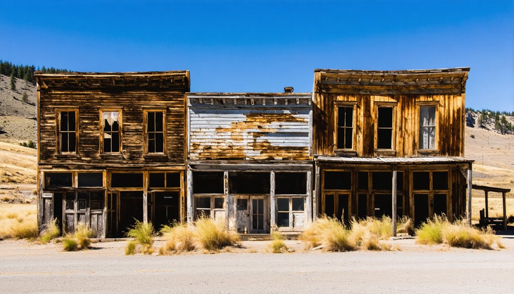
Hardman: Agricultural Center on Eastern Oregon Grasslands
Unlike most ghost towns born from mining booms, you’ll find Hardman emerged as an essential agricultural waypoint where freight wagons hauling Blue Mountains timber and Eightmile wheat belt grain converged on their way to Columbia River railheads.
The town’s positioning made it the mandatory rest stop for teamsters, supporting a flour mill that drew farmers from miles around and sustaining blacksmiths, livery stables, and hotels that served the surrounding wheat and cattle ranches.
Today you can still spot several weathered structures along the quiet main street, accessible via Highway 207, their frames testifying to decades when this plateau settlement orchestrated the movement of crops and livestock across eastern Oregon’s grasslands.
Historic Transportation Hub Role
At 3,600 feet on the high plateau grasslands near the Blue Mountains, Hardman occupied what 19th-century boosters called “one of the finest wheat, grain and stock countries” in Morrow County.
You’ll find the town’s real power lay in controlling transportation networks between interior ranches and Columbia River rail connections. Every freight team hauling wheat, wool, and livestock from points south passed through Hardman’s main street, making it the obligatory stopping point for teamsters moving goods across eastern Oregon’s vast distances.
Stage roads converged here, linking John Day, Heppner, and Columbia shipping points. The town’s livery stables, hotels, and blacksmith shops thrived on this constant flow of wagons and pack trains maneuvering freight routes through otherwise isolated grasslands.
Preserved Buildings and Access
Standing today at the heart of Hardman’s ghost town core, you’ll find a remarkably intact main street grid lined with weathered false-front commercial buildings that haven’t seen regular trade in decades.
The preserved architecture includes former general stores, boarding houses, and a prominent community hall—all wood-frame structures with original openings still visible beneath peeling paint. Church and school remnants complete the civic landscape that once served scattered ranchers and wheat farmers across this 3,600-foot plateau.
Ghost town exploration here requires planning: access follows county roads that can turn treacherous in winter, and most buildings remain in private hands.
You’re generally free to photograph from roadsides, but respect posted boundaries. Many structures stand weathered yet upright, while others show collapsed roofs from decades of high-elevation exposure.
Mining Boom and Transportation Networks in the John Day Region
When prospectors struck gold along Canyon Creek near the John Day River in 1862, they ignited one of Oregon’s most explosive regional rushes and set in motion a decade of fevered extraction that would reshape the entire inland corridor.
You’ll find that early mining methods centered on placer operations—pans and rockers worked the gravel bars—before investors erected an eight-stamp quartz mill in 1867 to crush hard-rock ore.
Hydraulic operations followed, demanding miles of ditches and flumes to blast hillsides apart.
The boom spawned critical transportation routes: Columbia River steamboats hauled miners and stamp-mill machinery upriver, while overland wagon roads threaded from the Oregon Trail through Baker to Canyon City, transforming remote camps into supply hubs.
What Remains: Structures, Foundations, and Interpretive Sites
Weathered storefronts and skeletal frames dot the high-desert plateau around John Day, offering tangible proof of the region’s rise and collapse.
Shaniko, perched seventy miles northwest, preserves more than forty original structures—its Columbia Southern Hotel stands three stories tall above boardwalks that creak under your boots, while the jailhouse and schoolhouse sink slowly into sagebrush that’s reclaiming every foundation crack.
Richmond huddles one mile east of Highway 207, its abandoned architecture from the 1872 stage-station era still upright against winter winds.
Lonerock’s 1898 Methodist church and schoolhouse function as defiant markers where community once thrived.
Across Sherman County’s wheat fields, you’ll find historical remnants reduced to rubble piles and concrete pads—Class B sites with dilapidated walls, Class A locations marked only by cemeteries and interpretive plaques where nothing stands.
Planning Your Visit: Access Routes and Seasonal Considerations
From Portland, your journey into ghost town country begins along I-84 through the Columbia River Gorge, where you’ll pass Hood River and The Dalles before making the critical decision: swing south on Highway 97 toward Shaniko’s wool-era relics fifty-five miles down the road, or continue east to Arlington before cutting south on Highway 19 through Condon and Fossil—a 3.5-hour route that deposits you at the Painted Hills.
Winter travel demands respect here. Remote roads turn sketchy when weather hits, and businesses vanish for the season without warning.
Check TripCheck.com before departing—conditions change fast. While main highways stay paved, reaching spots like Galena requires four-wheel drive, spare tires, and tolerance for rocky, muddy backroads.
Pack extra supplies. Eastern Oregon’s solitude rewards the prepared but punishes assumptions about services.
Preservation and Responsible Ghost Town Exploration
Standing before a sagging bunkhouse with its door hanging crooked and roof beams exposed to the sky, you face a choice that defines responsible exploration: step inside for that Instagram moment, or honor the fragility of what remains.
Historic preservation isn’t about fences and restrictions—it’s about ensuring future adventurers find what you discovered. That means no climbing on unstable structures, no pocketing rusty hardware or bottles, and no carving your initials into century-old siding.
These ghost towns sit on a patchwork of private ranches, BLM parcels, and federal lands where artifact removal violates state and federal law. Even seemingly worthless objects—nails, ledger scraps, stove parts—tell stories archaeologists and historians still piece together about John Day’s mining and ranching past.
Frequently Asked Questions
How Many Total Ghost Towns Are There in Oregon?
Like scattered relics on a treasure map, you’ll find 200 to 300 Oregon ghost towns depending on how you count them. Each carries historical significance from mining booms, logging camps, and frontier dreams that shaped the state’s rugged character.
One fascinating example is the history of Auburn, Oregon ghost town, which provides a glimpse into the lives of early settlers. Once a bustling hub during the gold rush, Auburn’s remnants echo stories of ambition and hardship that defined the era. Today, exploring these abandoned structures offers a unique experience for history enthusiasts and adventurous travelers alike.
Are Any Ghost Towns Near John Day Accessible in Winter?
Yes, Whitney ghost town offers excellent winter accessibility along maintained OR-7 near Prairie City. You’ll find visible building remnants right off the highway, though ghost town safety requires checking TripCheck for conditions and carrying emergency supplies in remote Eastern Oregon.
Can I Camp Overnight at These Ghost Town Sites?
You can’t camp directly at ghost town sites within monument boundaries due to NPS regulations, but you’ll find freedom on nearby BLM dispersed areas that respect the historical significance while offering primitive overnight spots along river corridors.
Which Ghost Town Is Closest to John Day?
Whitney’s your closest ghost town to John Day, sitting right off Highway 7. This former lumber hub’s got fascinating ghost town history—from its 1901 railroad days to local legends about stage robbers who once prowled the route.
Just a short drive away, you’ll find the history of hagan ghost town, which adds another layer to the region’s mysterious past. Once a thriving settlement, it now stands as a testament to the changes that shaped local communities. Exploring its remnants offers a glimpse into the lives of those who once called it home.
Do Any Ghost Towns Near John Day Charge Admission Fees?
You’ll find zero admission policies at ghost towns like Whitney, Galena, and Greenhorn—no ticket prices, no gates blocking your path. These ruins sit on public forest land, letting you wander freely through Oregon’s mining history.
References
- https://www.nationaldaycalendar.com/lists/12-oregon-ghost-towns
- https://www.co.sherman.or.us/ghost-towns-old-west/
- https://en.wikipedia.org/wiki/List_of_ghost_towns_in_Oregon
- https://kids.kiddle.co/List_of_ghost_towns_in_Oregon
- https://thatoregonlife.com/2016/04/road-trip-ghost-towns-eastern-oregon/
- https://www.pdxmonthly.com/travel-and-outdoors/2025/10/oregon-ghost-towns-history
- https://traveloregon.com/things-to-do/culture-history/ghost-towns/a-road-trip-back-in-time/
- https://www.historicsumpter.com/whitney-oregon-ghost-town/
- http://www.photographoregon.com/Whitney-Oregon.html
- https://www.youtube.com/watch?v=KwOQ_Z0MOlU


