You’ll find at least eight documented ghost settlements within 150 miles of Kenai Fjords National Park, abandoned between 1910 and 1957 as gold claims exhausted, salmon canneries closed, and highway construction bypassed coastal outposts. Aurora—a speculative settlement that never materialized beyond promotional literature—sits closest to the park, while Portlock’s 1950 abandonment and the Kennecott-McCarthy corridor’s National Historic Landmark buildings represent the region’s boom-and-bust extraction economy. Accessing these sites requires coastal charters, floatplanes, or overland routes, with seasonal windows dictating your exploration opportunities.
Key Takeaways
- Alaska’s ghost towns near Kenai Fjords include abandoned gold camps, cannery complexes, and logging outposts from the late 1800s and early 1900s.
- Portlock was abandoned in 1950 amid mysterious deaths, while Aurora was a fraudulent promotional scheme that never actually existed as a settlement.
- Access requires specialized transport like charter boats or floatplanes, with the optimal visiting window being mid-May through early September.
- Many sites are on private or Native corporation land, making legal trespassing a concern and requiring permission before visiting.
- Visitors face hazards from unstable structures and open shafts, while cultural respect is essential given Alaska Native community significance.
Understanding Alaska’s Ghost Town Heritage on the Kenai Peninsula
Because Alaska’s boom-and-bust extraction economy left physical scars across nearly every corner of the territory, the Kenai Peninsula presents a particularly dense archive of abandoned settlements—gold camps, cannery complexes, and logging outposts that flourished briefly in the late nineteenth and early twentieth centuries before collapsing into ruin.
You’ll find Canyon Creek and Sixmile Creek placers once drew thousands of seasonal miners who vanished when ore exhausted.
Road construction along Alaska Route 1 triggered systematic abandonment as populations consolidated into highway-linked hubs like Soldotna and Cooper Landing.
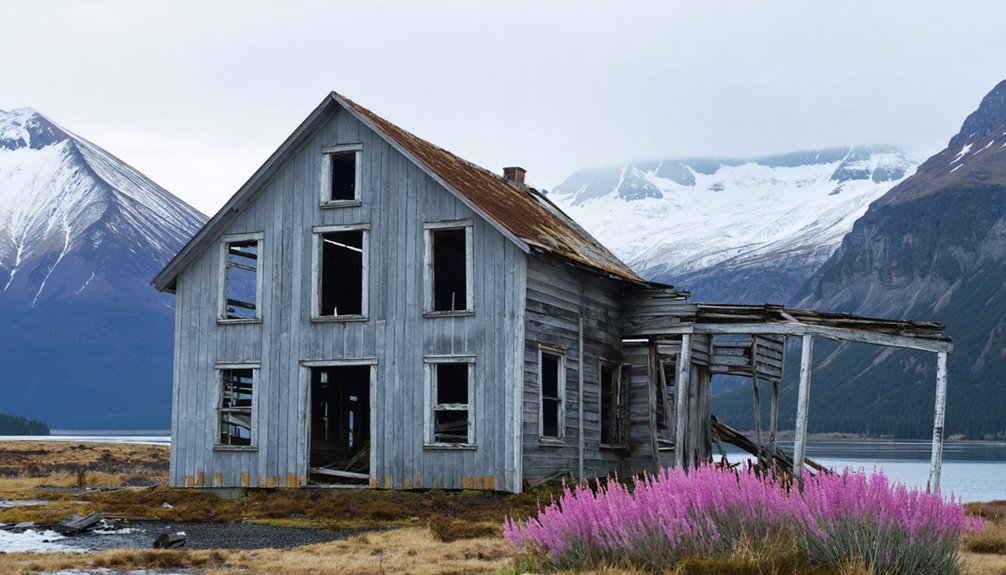
These ghost sites now function as contested terrain where economic history intersects cultural narratives: Suqpiaq oral traditions about forest beings layer onto cannery ruins, creating ghostly folklore that attracts modern seekers while obscuring the structural forces—resource depletion, transportation shifts, corporate consolidation—that actually emptied these camps. The native village of Portlock on the Kenai Peninsula stands as perhaps the most dramatic example, abandoned entirely due to mysterious deaths that locals attributed to Nantinaq, a bigfoot-like creature from Suqpiaq lore. The town’s post office closed in 1950 when the postmaster became the last resident to leave after decades of unexplained disappearances.
Aurora: The Closest Documented Ghost Settlement to Kenai Fjords
Among the scattered remnants of Kenai Peninsula’s extraction-era settlements, Aurora holds unusual distinction—not for its productivity or longevity, but for its complete fabrication.
Thomas C. Dunn’s 1901 scheme near Homer created one of Alaska’s most brazen hoaxes, platting a coastal community that never materialized beyond promotional literature.
Aurora’s historical significance lies in what it reveals about speculative excess:
- Location: Kachemak Bay, roughly 80–90 miles straight-line from Kenai Fjords’ Seward gateway
- Current status: Barren site, no standing structures
- Access: Boat transit from Homer required; no road infrastructure
- Physical remains: Possibly faint foundations, if anything survives coastal processes
- Documentation: Appears in official ghost settlements records as failed townsite
You’ll find nothing here but wilderness reclaimed—a cautionary tale against unchecked development schemes masquerading as opportunity. The site offers a stark contrast to Seward’s charming small-town atmosphere, which serves as the functional gateway to Kenai Fjords National Park today. Alaska’s 11 national parks collectively protect over 83 million acres of wilderness, with Kenai Fjords representing one of the state’s most accessible coastal sanctuaries.
How Resource Booms and Busts Shaped Coastal Alaska Communities
When you trace the mineralized veins and coal seams that drew prospectors to the outer Kenai coast from the 1850s onward, you’re following the economic logic that built—and abandoned—settlements like Aurora.
Gold strikes at Nuka Bay in 1923 and the Sonny Fox Mine’s brief productivity by 1928 created tight clusters of workers and supply camps, yet by 1933 USGS reports documented their collapse as ore bodies proved too small and shipping costs too high.
This cycle of extraction, temporary infrastructure, and rapid depopulation became the template for coastal ghost towns across southern Alaska, where every boom required accessible harbors and every bust left behind rotting wharves and silent cabins. The U.S. government’s increase of the gold price in January 1934 sparked a gradual rise in production during the early Depression years, briefly extending the lifespan of some marginal operations.
The discovery of oil at Swanson River in July 1957 shifted the peninsula’s economic gravity inland, drawing capital and workers away from coastal mining operations and accelerating the abandonment of remaining camps along the fjords.
Mining’s Rise and Fall
Gold fever gripped the Kenai Peninsula in the late 1880s, transforming coastal Alaska from subsistence territory into a landscape of speculative enterprise.
You’ll find mining legacies scattered across Nuka Bay and Turnagain Arm—testaments to economic fluctuations that built and demolished entire communities within decades.
The boom-bust cycle followed a brutal pattern:
- 133,800 oz placer gold fueled Hope and Sunrise as supply hubs for thousands of prospectors
- Alaska Hills Mine (1924) and Sonny Fox Mine (1926) shifted Nuka Bay toward commercial production
- Fixed pre-1933 gold prices made remote ore bodies uneconomic once high-grade pockets vanished
- World War II prioritized strategic materials over gold, accelerating closures
- Post-war investment favored road-accessible deposits, stranding boat-dependent fjord camps
Most settlements emptied, burned, or simply dissolved into coastal forests.
The geological foundation for this boom originated 65 million years ago when sea floor deposits of sands and muds began forming the peninsula’s gold-bearing quartz veins.
Commercial fishing and hunting introduced by European contact fundamentally altered resource availability that had sustained Native communities for millennia.
Transportation Infrastructure Dependency
Because miners and prospectors arrived faster than pack animals could supply them, the Alaska Central Railway pushed inland from Seward in 1903, anchoring a radial network of wagon roads, sled routes, and trails that tied distant camps to tidewater.
You’ll find that transportation evolution determined which settlements survived: when placer deposits near Hope–Sunrise exhausted in the 1920s, the Alaska Road Commission abandoned the 1907 wagon road, isolating boomtowns and triggering depopulation.
Highway completion in 1946 shifted freight flows toward junction communities, starving marine-dependent landings of revenue. Ghost town accessibility today reflects these cold calculations—communities lacking intermodal links (deepwater port, rail, highway) lost competitive position in fisheries and timber, forcing out-migration.
Road maintenance followed resource revenue, not settlement need, condemning bypassed camps to obsolescence. The railroad’s September 1908 receivership triggered Seward’s first economic collapse, demonstrating how financial instability in a single transportation corridor could devastate an entire coastal settlement’s viability. Modern Kenai Fjords infrastructure exhibits identical seasonal constraints, with Exit Glacier road closures from November through April replicating the isolation patterns that once emptied boom-era camps.
Kennecott and McCarthy: Premier Ghost Town Destinations Within Reach
When the mines closed in 1938, both communities emptied within weeks, preserving an authentic snapshot of early 20th-century mining life:
- 600 residents abandoned Kennecott overnight after final train departure
- Original mill buildings, boarding houses, and hospital remain standing
- McCarthy’s wooden boardwalks and storefronts survived decades of neglect
- National Historic Landmark status protects the district
- Visitor access requires crossing footbridge into roadless wilderness
Accessing Remote Ghost Sites by Boat, Plane, and Trail
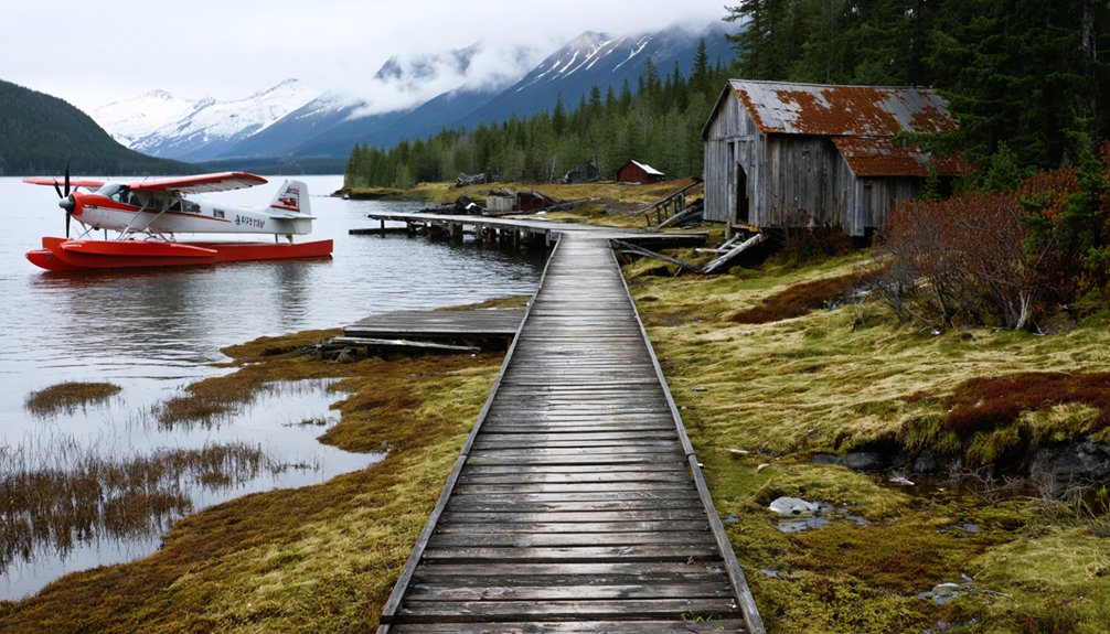
Reaching abandoned settlements around Kenai Fjords requires you to coordinate specialized transport—coastal charter boats from Seward or Homer, floatplane services operating under tight weather windows, or unmarked overland routes through alder thickets and unstable talus.
Each access mode imposes distinct logistical constraints: marine approaches depend on gulf swell forecasts and park landing regulations, aircraft weight limits restrict documentation gear, and trail-less bushwhacks demand bear-country protocols in drainages choked with salmon runs.
You’ll find that seasonal conditions—mid-summer’s brief calm versus shoulder-season fog banks and katabatic winds—ultimately dictate which ghost sites become reachable during any given field expedition.
Boat Charter Options
- Landing craft handle rocky foreshore debris fields near collapsed adits.
- Rigid inflatables permit grounding on mixed gravel-boulder beaches at low tide.
- Cabin cruisers carry gear for full-day transits (60–120 nautical miles round-trip).
- Skiff transfers from anchored motherships reduce grounding risk in hazard zones.
- Mid-May through early September defines the safe operational window for remote fjord penetration.
Expect NPS commercial-use permit verification before departure.
Bush Plane Air Taxis
Because designated landing strips don’t exist near most abandoned canneries and mining camps within Kenai Fjords National Park’s 670,000-acre envelope, NPS-authorized air taxi operators bridge the access gap using floatplanes, tundra-tire bush planes, and ski-equipped aircraft calibrated to coastal beaches, sheltered coves, and backcountry lakes.
Air taxi logistics require chartering entire aircraft—typically De Havilland Beavers or Otters—rather than buying per-seat tickets, giving you dedicated control over timing and landing zones near ghost sites wilderness regulations would otherwise shield.
Floatplane capabilities center on 900–1,200 lb payloads, accommodating photography gear, metal detectors, and camp supplies while accessing fjord-side ruins Seward- and Homer-based operators scout during flightseeing reconnaissance runs.
You’ll coordinate staged movements from Kenai and Moose Pass hubs, threading legal landing areas outside wilderness boundaries to reach isolated adits, cabins, and cannery skeletons conventional transport can’t touch.
Overland Hiking Routes
Unlike the mapped trail networks of inland Alaska mining districts, overland approaches to Kenai Fjords’ periphery ruins hinge on boat-to-foot changes choreographed around tide windows, swell forecasts, and the park’s roadless topography.
You’ll face hiking challenges that begin before you leave the beach: stranding risk on intertidal stretches, bushwhacks across alder and devil’s club, and elevation gains over unstable talus where game trails fade.
Resurrection Bay’s cannery remnants and Caines Head’s concrete WWII installations exemplify the model—water taxi drop, timed shoreline traverse, then steep climbs to ruins perched above tidal reach.
Overland routes demand:
- Tide-chart precision for coastal windows
- Drybagging gear through boulder landings
- Bushwhack navigation on trailless slopes
- Windproof layering against fjord gusts
- Self-extraction planning if weather closes return shuttles
What Remains: Structural Traces and Historic Footprints
When you approach the Kennecott mill complex today, the 14-story red structure rises against the glacier like a monument to industrial ambition frozen mid-operation.
The National Park Service has stabilized multiple mine buildings across this 1998-designated National Historic Landmark District, preserving ghost town architecture that once housed 600 residents. You’ll find general stores, recreation halls, and superintendent residences reflecting the corporate hierarchy of this 1903 mining camp.
Railroad tracks still trace the route to Cordova, completed in 1911, while copper ore outcroppings mark mountainsides where five operational mines extracted wealth until 1938.
McCarthy settlement sits five miles downtrack, where miners sought freedoms denied in company-controlled Kennecott.
Today, 200 residents maintain this mining heritage alongside preservation efforts protecting structural remnants from wilderness reclamation.
Combining Kenai Fjords Wildlife Viewing With Historic Exploration
While Kennecott’s copper mills and McCarthy’s mining infrastructure stand as landlocked monuments to industrial extraction, the ghost settlements scattered along Kenai Fjords National Park’s coastline tell a maritime story now overshadowed by the region’s premier wildlife-viewing economy.
Today’s cruises navigate past abandoned fox farms and fish camps where wildlife conservation has replaced extraction:
- Aialik and Harris Bays feature former fur-farming islands now protected as Steller sea lion haul-outs and puffin rookeries.
- McCarty Fjord and Nuka Bay remnants of mining operations mark orca and humpback feeding grounds.
- Caines Head’s WWII Fort McGilvray ruins anchor a marine wildlife corridor accessed by water taxi.
- Naturalists layer Indigenous Sugpiaq hunting traditions over modern whale sightings.
- Historic preservation markers share cliff faces with auklet and cormorant colonies.
You’ll find freedom in landscapes where human abandonment enabled ecosystem recovery.
Safety and Cultural Considerations When Visiting Abandoned Sites

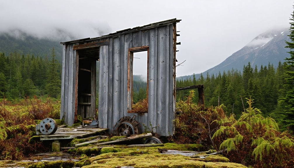
The structural integrity you assume when stepping onto a weathered boardwalk or ducking through a mine adit along Kenai Fjords’ coast often vanished decades before the wildlife returned.
Rot, corrosion, and freeze–thaw cycles leave open shafts obscured by vegetation and buildings prone to collapse under minimal weight. NPS advises extreme caution; unmarked pits, unstable tailings, and legacy contaminants demand rigorous cautionary measures—stay clear of sealed structures, heed closure signs, and carry updated rescue coordinates.
Many sites rest on Native corporation or private claim land where trespass carries legal consequences. Cultural respect extends beyond artifact prohibition: numerous “ghost towns” hold ongoing significance for Alaska Native communities whose ancestors worked, traded, or lived there.
Approach each ruin as both hazard and heritage.
Planning Your Multi-Park Itinerary: Kenai Fjords, Wrangell–St. Elias, and Beyond
- Allocate 2–3 days Kenai Fjords for coastal ruins and Exit Glacier access.
- Reserve 3–4 days Wrangell–St. Elias for Kennecott’s copper legacy and McCarthy Road relics.
- Schedule Kenai Fjords first or last to align with Seward’s rail and cruise terminals.
- Combine self-drive segments (Seward Highway, Glenn/Richardson corridors) with bush flights.
- Book June–September when Wrangell–St. Elias roads are passable and marine access peaks.
This circuit maximizes archival landscapes while respecting fragile structures.
Frequently Asked Questions
Are Any Ghost Towns Directly Inside Kenai Fjords National Park Boundaries?
No ghost towns exist within park boundaries—just abandoned mines. Zero documented townsites appear in official NPS records. You’ll find Kenai Fjords’ ghost town history concentrated outside its borders, where Alaska’s 100+ settlements reflect mining booms and regional economic shifts.
Exploring the ghost towns near Kobuk Valley National Park offers a glimpse into the past, as many of these remnants serve as poignant reminders of the once-thriving communities driven by the gold rush and mining activities. Each site tells a story of adventure and hardship, attracting those interested in the historical context of Alaska’s development. Visitors can trek through these abandoned locales, absorbing the atmosphere and imagining the lives that once filled these now-empty streets.
Can I Legally Remove or Take Artifacts From Ghost Town Sites?
No, you can’t legally remove artifacts—federal law strictly prohibits it. Artifact preservation protects cultural heritage on public lands, and the legal implications include substantial fines and criminal prosecution. These regulations safeguard Alaska’s historical record for future generations.
Which Ghost Town Is Easiest to Reach From Seward by Car?
Hope, Alaska—where gold-rush ghosts whisper along Turnagain Arm—is your nearest road-accessible relic, just 90 miles north via scenic routes on Seward Highway. Its historical significance pulses through weathered cabins you’ll discover yourself.
Do Guided Ghost Town Tours Operate Regularly From Kenai Fjords?
No guided tours focused on ghost town history operate regularly from Kenai Fjords. You’ll find marine wildlife cruises instead. For documented ghost town tours, you’d need to travel independently to Kennecott in Wrangell–St. Elias National Park.
What Permits Are Required to Visit Aurora or Other Abandoned Settlements?
You won’t need a permit application for casual visits to Aurora Spit or similar sites on NPS land—standard visitor regulations allow free backcountry access. However, crossing Port Graham Corporation boundaries requires their landowner permission beforehand.
References
- https://www.nps.gov/thingstodo/ghost-towns.htm
- https://curiouslens.com/blog/alaska-denali-kenai-fjords-wrangell-st-elias-national-parks
- https://motorcyclemojo.com/2015/09/alaska-ghost-towns/
- https://www.alaska.org/detail/kennicott-mine-ghost-town-walking-tour
- https://www.youtube.com/watch?v=Cz0IGc2Uy0E
- https://en.wikipedia.org/wiki/List_of_ghost_towns_in_Alaska
- https://www.kbbi.org/local-news/2022-11-03/local-lore-of-nantinaq-documented-on-discovery-channel-show
- https://www.onlyinyourstate.com/experiences/alaska/this-abandoned-ghost-town-is-downright-bone-chilling-ak
- https://live.laborstats.alaska.gov/sites/default/files/trends/may24art2_0.pdf
- https://vocal.media/horror/mysteries-of-portlock-alaska-and-the-abandonment-of-the-small-town-in-the-1900s


