You’ll find remarkable ghost towns scattered throughout Kingman’s surrounding mountains, each with distinct mining heritage. Oatman, 28 miles southwest, features wild burros and produced 1.8 million ounces of gold. Chloride, established in 1863, remains Arizona’s oldest continuously inhabited mining camp with its 1873 post office still operating. Hackberry preserves Route 66 nostalgia at its iconic 1934 general store, while abandoned sites like Goldroad, Mineral Park, and the steamboat hub of Hardyville offer glimpses into frontier commerce. Exploring these weathered settlements reveals the complete story behind Mohave County’s mineral wealth.
Key Takeaways
- Oatman, 28 miles southwest of Kingman, features wild burros, staged gunfights, and the historic 1902 Oatman Hotel from gold rush days.
- Chloride, established in 1863, offers weathered buildings, Roy Purcell’s cliff murals, and Saturday gunfights by an all-female troupe.
- Hackberry, 20 miles northeast of Kingman, showcases Route 66 nostalgia through its 1934 General Store filled with vintage Americana memorabilia.
- Goldroad sits along Route 66 between Kingman and Oatman, with mining operations ceasing in 1942 after government orders ended production.
- Signal, 22 miles south of Wikieup, contains scattered ruins from its 1870s boom supporting 800 McCracken Mine workers.
Oatman: Wild West Charm and Free-Roaming Burros
Nestled in the Black Mountains roughly 28 miles southwest of Kingman, Oatman stands as one of Arizona’s most authentic and accessible ghost towns, where Wild West history comes alive along a legendary stretch of Route 66.
You’ll discover Oatman history rooted in the 1860s gold rush, when prospector Johnny Moss first staked his claim. The town’s population once swelled beyond 10,000 during its peak mining years, with operations producing over 1.8 million ounces of gold.
Today, burro encounters define your visit as wild descendants of miners’ pack animals freely wander the streets, accepting treats from visitors. These burros are protected by law, symbolizing the town’s spirit and mining heritage.
The 1902 Oatman Hotel still stands on wooden sidewalks where staged gunfights recreate frontier days. This living ghost town maintains its rough-edged character while welcoming independent travelers seeking genuine Western experience.
Access to Oatman involves narrow, winding roads that add to the adventure but require careful navigation.
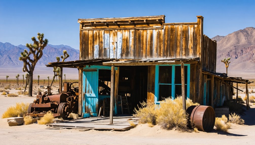
Chloride: Arizona’s Living Ghost Town
You’ll find Chloride perched at 4,000 feet in the Cerbat Mountains, where silver chloride ore drew prospectors in 1863 and built Arizona’s oldest continuously inhabited mining camp.
The town’s population surged to 5,000 residents when it became Mohave County’s seat in 1871, but mine closures by 1944 left behind the weathered false-front buildings and abandoned structures that now earn it the title “living ghost town.”
Exploring ghost towns around Wickenburg offers a unique glimpse into Arizona’s rich history and the remnants of its mining boom. Each visit reveals stories of the past, where the echoes of bustling life can still be felt among the dusty streets and decaying structures. Adventure seekers and history enthusiasts alike are drawn to these sites, eager to uncover the mysteries that lie within the ruins.
Today’s 150–300 permanent residents share their desert basin with visitors who come to explore historic jails and miner cabins, admire elaborate yard art installations, and hike to Roy Purcell’s 2,000-square-foot cliff murals painted during a 1966 counterculture encampment. All 20 occupied houses in town display some form of junk art, from flamingos fashioned from gas tanks to caterpillars crafted from bowling balls. The Santa Fe Railroad extended tracks to Chloride in 1898, dramatically reducing ore shipment costs and fueling the town’s economic boom.
Historic Mining Heritage
Rising from the Cerbat Mountains around 1862–1863, Chloride began as a silver mining camp that would become Arizona’s oldest continuously inhabited mining town—a distinction it maintains despite decades of boom, decline, and near-abandonment.
You’ll find evidence of Chloride’s mining technology scattered across Silver Hill, where 75–100 mines once extracted silver chloride ores alongside gold, lead, zinc, and turquoise.
The Tennessee Mine anchored operations, while the Schuylkill Mine and neighboring lodes sustained the district through six decades of production.
The economic impact was staggering—5,000 residents at peak, county seat status in 1871, and a Santa Fe Railroad connection from 1898.
Yet by 1944, rising costs ended large-scale mining, transforming Chloride into a ghost town that refused to die completely.
The US Post Office, which opened in 1873 and survived five relocations and a fire, now operates from the corner bar as Arizona’s oldest continuously operating post office.
Today, approximately 150 residents call Chloride home year-round, including retirees, artists, and musicians who have preserved the town’s creative counterculture heritage.
Modern Day Attractions
Unlike fully abandoned settlements that linger as silent monuments to frontier ambition, Chloride defies the traditional ghost town definition through its 350 remaining residents who maintain the settlement’s century-old rhythms.
You’ll discover authentic frontier experiences through these modern attractions:
- Saturday High-Noon Gunfights – The world’s only all-female gun fighting troupe performs mock shootouts at Cyanide Springs, keeping Western traditions alive without tourist crowds.
- Roy Purcell’s Cliffside Murals – Navigate a 1.3-mile four-wheel-drive road past abandoned mines to view 2,000 square feet of symbolic granite paintings featuring fertility goddesses and ancient petroglyphs. These murals were originally painted in the 60s and later repainted in the 80s to preserve their vibrant imagery.
- Local Artisans’ Installations – Flamingos welded from gas tanks and telephone-topped cemetery graves showcase independent creative spirit throughout town. The town features vintage gas pumps among its photogenic vintage elements that create perfect backdrops for desert photography.
- Ghost Town Festivals – Weekend karaoke at Yesterdays Restaurant and seasonal reenactments celebrate frontier heritage with minimal commercial interference.
Hackberry: Route 66 Nostalgia and Mining History
Twenty miles northeast of Kingman, you’ll find Hackberry, a settlement born in 1874 when silver miners established a camp beneath the Peacock Mountains.
The town’s name came from a hackberry tree growing beside a spring near Jim Music’s 1875 silver discovery, though the mines played out by 1919.
What survived the mining bust was the 1934 Hackberry General Store—complete with its vintage Conoco station—which became one of Route 66‘s most photographed landmarks after artist Bob Waldmire restored it in 1992.
The store sits at an elevation of 3,583 feet in this tiny village that clings to life along the Mother Road, where roughly 321 residents call home today.
Today, visitors can browse quirky memorabilia and souvenirs that capture the spirit of classic Americana at this iconic roadside stop.
Silver Mining Origins
What made Hackberry different from flash-in-the-pan camps:
- Dependable water source – The spring at the mountain’s base sustained miners and livestock year-round.
- Rich silver veins – Hard-rock deposits eventually yielded $3 million in gold and silver combined.
- Strategic location – East-side Peacock Mountain positioning allowed efficient ore extraction.
- Dual economy – Ranching operations supplemented mining, creating stability when ore prices fluctuated.
The town’s namesake hackberry tree still marked the main shaft when the post office opened in 1878.
Vintage Gas Station Landmark
Hackberry’s silver veins eventually played out by the early 1900s, but the town found new life when Route 66 arrived in 1926.
The 1934 Northside Grocery and Conoco Station became a lifeline for westward-bound travelers seeking opportunity during the Depression era.
When Interstate 40 bypassed this section, the station transformed into a museum celebrating the “Mother Road’s” golden age.
You’ll find vintage memorabilia filling every corner—Burma-Shave signs, Route 66 tin advertisements, and classic automobiles displayed outside weathered service garages.
Route 66 artist Bob Waldmire operated this collector’s paradise, traveling in his orange 1972 VW Microbus and inspiring Pixar’s “Cars” character Fillmore.
The vintage Mobil pumps with Pegasus logos and period Corvettes create perfect nostalgic photography opportunities against Arizona’s craggy mountain backdrop.
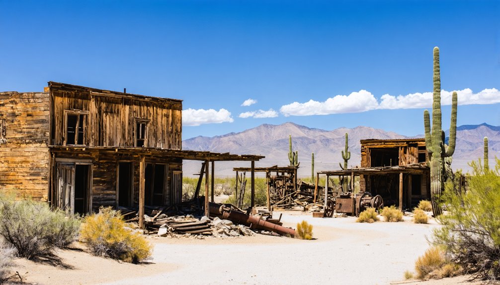
Goldroad: Abandoned Gold Mining Ruins
You’ll find the ruins along Route 66 between Kingman and Oatman, where foundations and scattered remnants mark what once thrived:
- Post office established April 15, 1902 when the camp formalized into a proper town.
- Gold Road Club served miners alongside Lovin’s store and freighting operations.
- Electric power from Kingman Powerhouse (1907-1911) enabled efficient underground operations.
- Government-ordered closure in 1942 during WWII ended operations permanently.
Mineral Park and Cedar: Remote Mountain Mining Camps
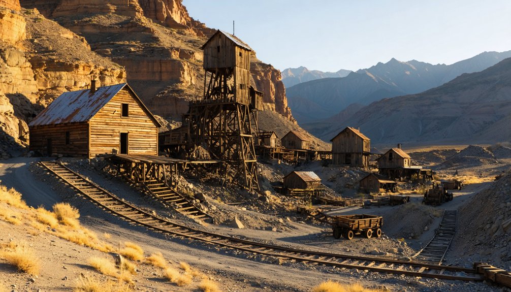
While Goldroad clung to Route 66‘s dusty corridor, Mineral Park rose in splendid isolation high in the Cerbat Mountains, where silver veins and turquoise deposits promised fortunes worth the brutal haul up juniper-covered slopes.
Mineral Park history began around 1871 when prospectors discovered rich ores that soon supported 700 residents—enough to claim the county seat from Cerbat in 1873.
You’ll find scant trace of this once-thriving hub today; modern open-pit copper operations consumed the townsite, leaving only a cemetery within restricted mine property.
Water scarcity plagued residents who hauled drinking supplies from miles away, while ore shipments traveled absurdly to Wales for processing.
When Kingman seized the county seat in 1887, citizens literally removed courthouse records overnight, sealing Mineral Park’s fate alongside Cedar mining legacy.
Hardyville: Colorado River Steamboat Landing
Long before Bullhead City’s casinos lit the Colorado River’s banks, William Harrison Hardy recognized the strategic value of a sandy landing where steamboats could tie up and wagons could fan out toward the silver camps of the Cerbat Mountains.
Founded in March 1864, Hardyville history reveals a calculated venture in frontier capitalism—controlling both the ferry crossing and toll roads to interior mines.
Hardyville’s River Commerce Operations:
- Steamboat Terminal – Sternwheelers from George A. Johnson & Co. delivered mining equipment and supplies to Hardy’s warehouses.
- Freight Hub – Teamsters hauled ore and provisions between the landing and Mineral Park’s silver districts.
- Toll Road Network – Hardy charged fees for wagon access to Cerbat Mountain mining camps.
- Strategic Monopoly – Competition arrived in 1881 when Polhamus Landing opened five miles upriver, breaking Hardy’s grip.
Signal, Stockton, Cerbat, and Katherine: Additional Ghost Town Discoveries
Beyond Hardyville’s vanished riverfront, Mohave County’s interior mountains concealed a constellation of silver camps that burned bright and faded fast.
Signal mining operations twenty-two miles south of Wikieup supported 800 residents and 200 buildings during the McCracken Mine’s 1870s boom—complete with thirteen saloons serving thirsty millworkers.
At its peak, Signal’s 800 residents kept thirteen saloons busy serving silver miners working the McCracken operations.
You’ll need high-clearance vehicles to reach its scattered ruins today. The Cerbat camp north of Kingman similarly thrived on silver strikes before railroad development at Kingman diverted commerce away.
Stockton’s decline followed the same pattern as river traffic dwindled. Katherine’s connections to this network of remote camps remind you that Arizona’s mining frontier demanded resilience: shopkeepers ordered supplies six months ahead, knowing isolation meant self-reliance or failure.
Frequently Asked Questions
What Is the Best Time of Year to Visit Ghost Towns Near Kingman?
The best months are March through May and September through November, when moderate weather conditions let you explore Oatman’s wooden boardwalks and Chloride’s mining ruins comfortably without summer’s punishing heat or winter’s limiting daylight.
Are the Roads to These Ghost Towns Suitable for RVS and Large Vehicles?
Don’t let road conditions become roadblocks—Oatman and Chloride welcome larger RVs on paved routes, though Route 66’s switchbacks challenge long rigs. Remote sites like Cerbat impose strict vehicle restrictions requiring high-clearance exploration.
Can You Camp Overnight Near Any of the Kingman Area Ghost Towns?
You’ll find overnight camping at Kentucky Camp and Swansea under BLM management, though you should verify current camping regulations beforehand. Remote locations require self-sufficiency planning and awareness of overnight safety considerations in Arizona’s high desert terrain.
Do I Need Permits to Explore Old Mines Near These Ghost Towns?
Yes, you’ll need permits for most exploration—ironic, since these mines once symbolized frontier freedom. BLM land allows casual visits, but state trust and active claims require authorization. Always respect mine safety barriers and historical significance protections.
Which Ghost Towns Near Kingman Offer Guided Tours or Visitor Centers?
Oatman offers guided day tours from regional operators and features a museum-jail visitor center showcasing mining-era memorabilia. You’ll find guided experiences highlighting historical significance through staged gunfights, burro encounters, and interpretive signage throughout this Route 66 destination.
References
- http://genealogytrails.com/ariz/mohave/ghost-towns.html
- https://www.visitarizona.com/like-a-local/4-arizona-ghost-towns-you-may-have-never-heard-of
- https://www.ghosttowns.com/states/az/azmohave.html
- https://www.tripadvisor.com/Attraction_Review-g31295-d10801088-Reviews-Oatman_Ghost_Town-Oatman_Arizona.html
- https://www.mapquest.com/us/arizona/chloride-ghost-town-369360937
- https://www.youtube.com/watch?v=Hl0qxYmKPoE
- https://roadtrippers.com/magazine/oatman-arizona-burros-gold-ghosts/
- https://www.legendsofamerica.com/az-oatman/
- https://www.youtube.com/watch?v=pv5RgciTnFE
- https://pinintheatlas.com/travel-blogs/oatman-ghost-town/


