
You’ll find over a dozen ghost towns within fifty miles of Lancaster, remnants of California’s extractive boom-and-bust era from the 1850s through 1950s. Tropico, established in the 1870s for fire clay and gold mining, and Mentryville, founded in 1876 as California’s first oil pipeline town, stand as the most significant preserved sites. The Mojave Desert’s harsh landscape—marked by four inches of annual rainfall and temperatures exceeding 110°F—claimed these once-thriving communities after mines closed and oil wells ran dry. Further exploration reveals their fascinating Hollywood connections and ongoing restoration efforts.
Key Takeaways
- Tropico Ghost Town, established in the 1870s for mining, features 10 miles of tunnels and houses the world’s largest time capsule.
- Mentryville, founded in 1876, showcases California’s first oil pipeline and preserved structures from pioneering petroleum drilling operations.
- Ten ghost towns exist within fifty miles of Lancaster, many undergoing community restoration and preservation efforts by local volunteers.
- Antelope Valley’s desert landscape and historic sites attract Hollywood productions, serving as filming locations for major movies and Westerns.
- Economic booms from gold mining, oil extraction, and borax operations created thriving communities that declined after resource depletion.
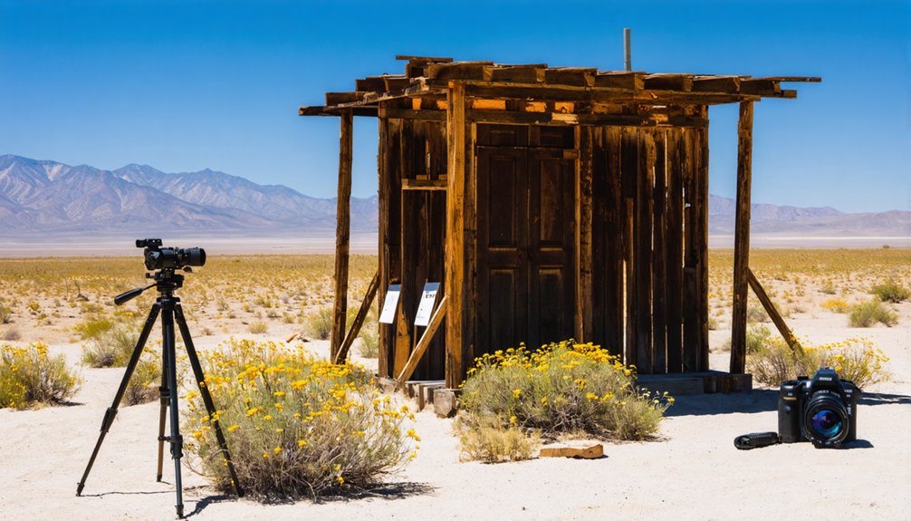
Historic Mining Town of Tropico
Long before Tropico earned its reputation as one of California’s more successful gold mines, Ezra Hamilton worked the windswept slopes of what locals called Hamilton Hill in the 1870s and 1880s, extracting fire clay that proved superior to anything available near Los Angeles.
His pottery works depended on that quality clay for bricks and pipe. Then in 1894, Hamilton panned gold from the same clay deposits, traced the color underground, and struck the mother lode.
From clay for bricks to underground gold—Hamilton’s 1894 discovery transformed pottery deposits into the legendary mother lode.
The property changed hands through Antelope Mining Company in 1908, then Tropico Mining & Milling Company in 1909—cementing the Tropico history that would define this corner of Kern County.
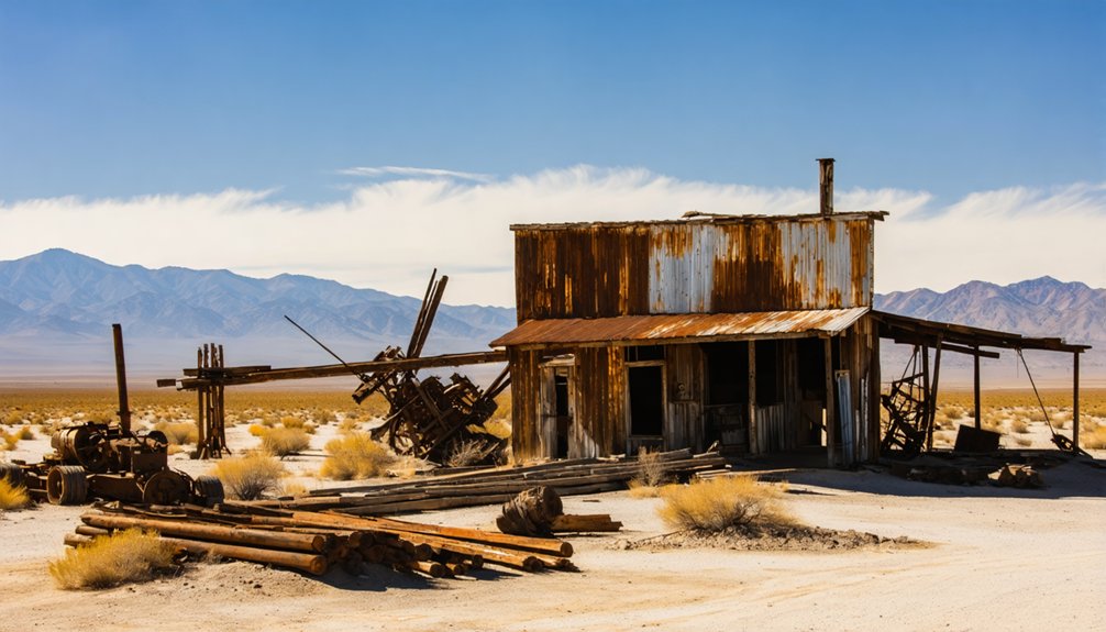
The Mining legacy stretched from the 1890s through the late 1950s, leaving behind 10 miles of tunnels and 50,000 tons of tailings. During the 1920s, operators constructed the Tropico Mill, equipped with a rotary ball mill circuit that processed ore and discharged waste onto the surrounding alluvial fans. In 1966, the abandoned mine gained new fame when it became home to the Tropico Time Tunnel, sealed with everyday items from mid-20th century life and designated by Guinness as the world’s largest time capsule.
Mentryville Oil Boomtown and State Historical Landmark
Tucked into Pico Canyon’s rugged folds in the Santa Susana Mountains, Mentryville rose from the chaparral as California’s first commercially successful oil boomtown—a distinction earned when French-born driller Charles Alexander Mentry brought in the legendary Pico No. 4 well in September 1876.
This oil boom sparked what became Standard Oil of California, later Chevron, establishing the town’s legacy in West Coast petroleum history. At its peak, over 100 families populated this strictly managed company town, where Mentry’s 13-room redwood mansion overlooked operations and California’s first oil pipeline snaked five miles to Newhall.
The Mentryville history includes pioneering steam-powered drilling and Pico No. 4’s remarkable 114-year production run until 1990. Following Alex Mentry’s death in 1900, workers gradually abandoned the town, transforming the once-bustling settlement into a ghost town even as oil production continued for nearly another century. Today, preserved structures stand as monuments to the wildcatters who launched an industry.
The site’s historical significance extends beyond petroleum extraction, as Mentryville featured Santa Clarita’s first schoolhouse, established in 1885 to serve the growing community of oil workers and their families.
Desert Landscape and Geographic Setting of Antelope Valley
The Antelope Valley spreads across the westernmost reach of the Mojave Desert as a vast wedge-shaped basin, its 2,200 to 3,000 square miles cradled between the San Gabriel Mountains to the south and the Tehachapi and southern Sierra Nevada ranges to the north.
You’ll find yourself standing 2,100 to 3,000 feet above sea level on alluvial plains where desert ecology shapes everything—Joshua tree woodlands, creosote bush scrub, and scattered juniper anchor the landscape against persistent 14–20 mph winds.
The high-desert climate delivers only four inches of rain annually, with summers blazing past 110°F and winters occasionally dusting the basin with snow.
Historic accounts describe former grasslands and abundant springs before groundwater decline transformed this frontier, where the San Andreas and Garlock faults mark boundaries that once drew prospectors and settlers into unforgiving terrain. The Garlock Fault serves as the defining boundary between the Mojave Desert and the mountainous regions that frame the valley’s northern edge.
Despite the valley floor’s 52-mile width, the elevation varies by only 838 feet, demonstrating the remarkable uniformity of this ancient basin’s topography.
Hollywood Productions and Film Location History
When Hollywood scouts first ventured north from Los Angeles in the 1920s, Antelope Valley‘s scrubland hills and weathered mining camps offered everything a Western needed—wide horizons, rock outcrops, and desolate townsite skeletons that required no set dressing.
Tropico Ghost Town became a working film location, hosting “Blazing Saddles” and “Ocean’s Thirteen” among its ore-stained structures. The Lake Los Angeles butte dubbed “Phantom Hill” appeared in both its namesake feature and “Gunsmoke” episodes, while street names commemorating “Mackenna’s Gold” and “Rawhide” map the area’s cinematic lineage.
Polsa Rosa Ranch near Acton evolved into a standing frontier compound, its facades repurposed project after project. You’ll find the Antelope Valley Film Commission still recruiting productions to defunct taverns and near-ghost communities, preserving Hollywood’s desert legacy through commercial shooting permits rather than tourist brochures. The region’s varied landscapes—including mountains, arid terrain, and distinctive Joshua trees—continue attracting productions seeking alternatives to Los Angeles filming complications. The abandoned mining town from the early 1900s, once operated as a museum before becoming privately owned and marketed exclusively as a film location for professional productions.
Accessibility and Visiting Options for Ghost Town Enthusiasts
Unlike Hollywood’s backlot relics that vanished beneath condominiums, Lancaster’s surrounding ghost towns remain accessible through a hub-and-spoke network of desert highways radiating from the Antelope Valley floor.
Randsburg sits ninety minutes north on maintained pavement, offering weekend cafés and antique shops among weathered storefronts.
Calico, two hours east, operates as a county park with entrance fees, restrooms, and mine tours—ghost town accessibility packaged for families.
On Saturday nights, ghost tours wind through Calico’s spooky history and the 1880s Maggie Mine.
Ballarat demands four hours and high-clearance vehicles across washboard tracks where cell signals die and visitor services shrink to a lone caretaker’s shack.
You’ll fuel in Mojave or Ridgecrest before pushing into Panamint Valley’s silence, carrying printed maps and emergency water.
Commercial UTV tours now trace mining ruins near Randsburg, but the loneliest camps still require self-reliance and dirt under your tires.
Back in Lancaster proper, guided ghost tours depart nightly from the cemetery, covering a 1-mile walking distance through haunted locations without requiring printed tickets.
Resource Extraction Industries That Built These Communities
You’ll find that ghost towns around Lancaster owe their brief existence to two extractive industries: hard-rock mining and petroleum drilling.
Gold strikes in Soledad Canyon during the 1850s–1860s and the Tropico Mine’s late-1890s boom pulled thousands of prospectors, merchants, and laborers into Antelope Valley camps that vanished once ore grades dropped or wartime shutdown orders arrived in 1942.
Borax operations by Pacific Coast Borax Company—at one point supplying nearly 50% of global demand—created company towns along rail spurs that emptied overnight when deposits shifted or markets collapsed, leaving you with the skeletal remains of communities built entirely on single commodities.
Mining Operations and Settlement
As prospectors scattered across the Antelope Valley hills in 1898 following reports of gold north of Lancaster, the region’s destiny shifted from quiet agricultural outpost to bustling supply hub for dozens of mining camps.
You’ll find that mining technology of the era—stamp mills, ore wagons, and hand-drilled shafts—dictated where men built their shelters and staked claims.
Settlement patterns emerged organically: tent cities near productive veins, company bunkhouses beside borax pits, and ramshackle boarding houses along freight corridors linking Lancaster’s railhead to remote diggings.
Hamilton’s operations near Rosamond and the massive Tropico Mine employed hundreds, anchoring worker camps that thrived until ore played out or modernization relocated crews.
These settlements rose fast, burned bright, then emptied—leaving behind the skeletal infrastructure you explore today.
Oil Boom Economic Impact
The Antelope Valley’s economic trajectory took a decisive turn when wildcatters pushed northward from the Los Angeles Basin’s oil frenzy of the 1920s.
Though the region never matched the staggering output of Signal Hill’s 68 million barrels in 1923 or Long Beach’s quarter-million barrels daily, you’ll find the same pattern repeated here: sudden oil wealth transformed ordinary ranchers into millionaires overnight, while roughnecks lived in tar-paper shacks beside derricks.
This economic inequality defined these communities from their inception.
Unlike Signal Hill’s “Porcupine Hill” density, Antelope Valley strikes remained scattered and modest.
When wells ran dry, there wasn’t enough infrastructure to sustain towns built solely on black gold.
The freedom these prospectors sought—quick fortunes without Eastern establishment interference—proved fleeting as reserves depleted faster than replacement industries could emerge.
Preservation Efforts and Heritage Organizations
You’ll find that the ghosts of Lancaster’s mining and utopian settlements haven’t been abandoned to oblivion—state and local preservationists have stepped in to save what remains.
Mentryville earned California State Historical Landmark status and now operates under the Santa Monica Mountains Conservancy’s stewardship, offering docent-led tours through its 800-acre oil-boom townscape.
Meanwhile, the ruins of Llano del Rio, that failed socialist colony east of Palmdale, gained formal recognition in state historic inventories, anchoring a broader effort to catalog and protect Antelope Valley’s fragile heritage sites before development erases them entirely.
State Historical Landmark Designations
Several ghost towns scattered across the desert landscape near Lancaster carry official California Historical Landmark designations, placing them under the state’s formal heritage preservation framework.
You’ll find Mentryville (No. 516) recognized for its pioneering role in California’s oil industry, while Llano del Rio (No. 933) commemorates the West’s most significant non-religious utopian experiment.
These landmark criteria demand proven historical significance, structural integrity, and statewide importance—standards evaluated by the Office of Historic Preservation and State Historical Resources Commission.
When you visit these sites, you’re walking through officially protected history. The designations trigger CEQA environmental review for any development threats, establish eligibility for preservation grants, and guide local zoning protections.
It’s California’s commitment to keeping your access to authentic frontier stories intact.
Conservancy Management and Operations
While California’s landmark designations establish legal protection for ghost towns near Lancaster, their actual survival depends on conservancy management and organizational oversight.
ghost towns in california history serve as poignant reminders of the state’s rich and varied past. Efforts to preserve these sites not only protect the physical structures but also the stories and memories tied to the communities that once thrived there. As interest in California’s ghost towns continues to grow, more initiatives are emerging to ensure these historical treasures are maintained for future generations.
You’ll find the Santa Monica Mountains Conservancy‘s stewardship of Mentryville’s 800-acre site demonstrates significant conservancy benefits—including docent-led tours, structural maintenance standards, and protective regulations preventing unauthorized damage. The conservancy coordinates with state offices to preserve historic buildings while enabling public access for heritage tourism.
However, management challenges emerge when ghost towns shift to private ownership, as Tropico’s case illustrates. Once a public museum, it’s now fenced off, marketed primarily as a film location rather than a cultural destination.
Without conservancy frameworks, commercial priorities often overshadow preservation, limiting your ability to experience these historical sites firsthand.
Community Restoration Projects
Beyond formal conservancy oversight, grassroots community restoration projects breathe tangible life back into the desert’s abandoned settlements.
You’ll find volunteers stabilizing false-front buildings and wooden boardwalks at Randsburg, where community engagement transforms weekends into living history. Locals adapt saloons into cafes and museums, generating preservation funding through visitor spending rather than waiting for institutional grants.
Ten ghost towns within fifty miles of Lancaster benefit from regional mapping initiatives that prioritize restoration candidates. Period-appropriate paint colors, reconstructed porches, and historically inspired signage emerge from hands-on work parties.
These efforts blend arrested decay strategies with adaptive reuse, letting you walk authentic mining-era streetscapes maintained by people who refuse to let the desert erase their heritage. Heritage events and off-road gatherings cement ongoing support.
Additional Ghost Towns Within 50 Miles of Lancaster
The Antelope Valley and western Mojave Desert hold a remarkable concentration of abandoned settlements—Geotab’s extensive dataset identifies ten ghost towns within a 50-mile radius of Lancaster, each marking a chapter in California’s extractive economy.
exploring ghost towns near Mammoth Lakes can offer a different perspective on California’s history of mining and settlement. These locations, often shrouded in mystery and nature’s reclaim, provide a unique backdrop for adventurers and history enthusiasts alike. As visitors wander through the remnants of these once-thriving communities, they can uncover stories of resilience and the passage of time.
Among these fascinating sites are ghost towns in San Carlos, where the echoes of former lives linger in the crumbling structures and dusty streets. Adventurers exploring these forgotten places can marvel at how nature has intertwined with man-made relics over the decades. Each town holds its own history, inviting visitors to imagine the lives that once filled these now-silent spaces.
Abandonment causes typically trace to resource depletion and market crashes that shuttered mining camps and company towns almost overnight. Tropico, perched on a hill near Rosamond, exemplifies this pattern: its gold-mining heyday gave way to complete desertion, though the clustered structures now serve film productions like *Blazing Saddles* and *Ocean’s Thirteen*.
The cultural significance of these sites extends beyond Hollywood backdrops—they’re tangible records of frontier ambition, preserved along rail corridors and desert highways that once channeled westward migration and now guide road-trippers seeking authentic remnants of California’s boom-and-bust cycles.
Boom and Bust Cycles That Shaped Settlement Patterns
Lancaster’s ghost towns didn’t materialize randomly across the desert—they emerged as physical echoes of economic forces that repeatedly built up and dismantled communities across the Antelope Valley.
You’ll find settlements abandoned after the 1894 drought devastated wheat ranches, while others survived temporarily on gold and borax discoveries before those resources played out.
The Pacific Coast Borax Company‘s operations attracted thousands, then left empty structures when mines closed.
Railroad speculation created boom towns that vanished when Southern Pacific rerouted lines or agriculture failed.
These economic cycles—from Moses Langley Wicks’s land speculation in the 1880s through aerospace cutbacks in the 1990s—transformed thriving communities into ghost towns within decades, leaving behind weathered buildings as evidence of fortune’s fickleness across these unforgiving plains.
Frequently Asked Questions
Are There Any Guided Night Tours Available at Ghost Towns Near Lancaster?
Guided night tours at ghost towns near you aren’t regularly offered. You’ll find daytime UTV-guided experiences around Randsburg, but for nighttime exploration and night photography, you’re mostly on your own among the desert ruins.
What Safety Precautions Should Visitors Take When Exploring Abandoned Mining Structures?
You’ll want to respect structural integrity by avoiding timber frames and unstable platforms, maintain wildlife awareness in confined spaces, and honor “Stay Out, Stay Alive” warnings—these historic sites demand cautious reverence over reckless adventure.
Can Visitors Collect Artifacts or Souvenirs From Accessible Ghost Town Sites?
You can’t legally collect artifacts from ghost towns; federal and state laws protect historic items. Artifact preservation and ethical collecting mean photographing relics instead—leaving them honors the past while preserving freedom for future explorers.
Are There Camping Facilities Available Near Ghost Towns in the Lancaster Area?
You’ll find camping amenities at Calico Ghost Town’s on-site campground with full hookups, while nearby campgrounds on BLM land serve Randsburg and other remote sites, letting you explore freely across the desert’s historic mining regions.
What Is the Best Season to Photograph Ghost Towns in Antelope Valley?
Late fall through early spring offers you the finest light and comfortable temperatures for ghost town photography. You’ll capture dramatic shadows, spring blooms, subtle autumn colors, and that nostalgic desert clarity without summer’s punishing heat.
References
- https://en.wikipedia.org/wiki/List_of_ghost_towns_in_California
- https://clui.org/ludb/site/tropico-ghost-town
- https://usghostadventures.com/americas-most-haunted-trending/ghost-towns-to-visit-on-your-summer-road-trip-along-route-66/
- https://www.youtube.com/watch?v=qioYNkFniLg
- https://www.geotab.com/ghost-towns/
- https://planning.lacounty.gov/blog/historic-resources-in-the-antelope-valley-and-surroundings/
- https://la-explorer.com/visiting-calico-ghost-town/
- http://www.rosamondca.us/history/time_capsule.htm
- https://digital-desert.com/a/tropico-gold-mine/
- https://www.youtube.com/watch?v=bYo2pIov5QM


