You’ll discover fourteen documented ghost towns within 90 minutes of Lassen Volcanic National Park, remnants of the mid-1850s gold rush that transformed Honey Lake Valley. Sites like Diamond Mountain and Hayden Hill produced over 21,800 ounces before economic decline created today’s weathered ruins. Visit between late June and September when unpaved access roads remain passable, and bring offline navigation tools since cellular service is nonexistent. Federal archaeological protections prohibit artifact removal, preserving these settlements’ authentic character. The following sections detail ideal routes, essential safety preparations, and photographic techniques for documenting this frontier heritage.
Key Takeaways
- Fourteen documented ghost towns and semi-abandoned sites exist within a 90-minute radius of Lassen Volcanic National Park.
- Southern sites feature weathered cabins and mining adits; northern clusters display railroad remnants near the Nevada border.
- Visit between late June and September for optimal snow-free access; Highway 89 closes November through June.
- Federal law prohibits artifact removal and structural disturbance; photograph freely but leave everything in place.
- Bring offline maps, GPS devices, adequate water, emergency shelter, and expanded first-aid supplies for backcountry exploration.
Understanding the Historic Mining Heritage of Lassen County
The discovery of gold deposits south of Peter Lassen’s trading post in the mid-1850s transformed Honey Lake Valley from a waystation along emigrant trails into a node of permanent Euro‑American settlement.
You’ll find that early prospectors brought blacksmithing equipment and agricultural implements alongside their mining tools, establishing mixed homesteads that anchored community dynamics distinct from California’s transient camps.
Lassen’s ditch system exemplified adaptive mining techniques, channeling water to placer claims and enabling sustained small-scale extraction.
By the 1890s, districts like Diamond Mountain and Hayden Hill had produced continuously for two decades, yielding over 21,800 ounces from combined placer and lode operations.
This persistent activity built townsites, supply networks, and social institutions—infrastructure that would later define the county’s ghost town legacy when ore bodies exhausted and economic viability collapsed.
Planning Your Ghost Town Adventure: Route Selection and Timing
Surviving infrastructure from Lassen County’s multi-decade mining boom now presents navigational challenges that demand careful route selection and seasonal planning.
You’ll need to master route optimization across mixed terrain—paved highways shift to graded gravel, then deteriorate into rough 4×4 tracks approaching remote ore-processing ruins. Site prioritization depends on vehicle capability and seasonal access windows; late June through September offers snow-free passage, while shoulder seasons impose mud and closure risks at elevations exceeding 8,000 feet.
Effective planning requires multi-source cartographic research: USFS maps, BLM district records, and specialized ghost-town atlases reveal current road status and legal access corridors. Notable destinations like Bodie State Historic Park require checking road conditions during off-season visits, as access along the 13-mile route off Highway 395 becomes particularly challenging outside summer months.
Cellular coverage vanishes beyond maintained routes, making offline GPS tracks non-negotiable. Fire-season closures and active mining claims further restrict movement, necessitating pre-departure agency consultation to avoid trespass citations or dangerous detours. Comprehensive lists of Nevada ghost towns can supplement California-focused resources for expanded regional exploration.
Essential Gear and Safety Preparations for Backcountry Exploration
Because Lassen’s ghost towns occupy isolated terrain where infrastructure collapsed decades ago, your survival margin depends on systematic gear selection across five interdependent categories: navigation and communication, environmental protection, sustenance and shelter, medical readiness, and tool redundancy.
Download offline maps to CalTopo or Gaia GPS; carry topo maps, compass, and satellite messenger where cell towers don’t reach. Layer moisture-wicking base, insulating mid, and waterproof shell against Sierra weather volatility.
Pack 2–3 liters water capacity with filtration for questionable springs, plus emergency shelter—ultralight tarp or bivy—and surplus rations. Expand first-aid kits with trauma dressings, splint material, and irrigation syringes for cuts from rusted metal or volcanic scree. A headlamp provides essential visibility if exploration extends beyond daylight hours in these remote locations. Continue education with advanced safety workshops to build skills in terrain assessment and emergency response specific to abandoned mining areas.
Implement safety protocols that prohibit entering mine adits, shafts, or structures with compromised timber; helmet and eye protection mitigate rockfall hazards around ruins.
Top Ghost Town Sites Within Day-Trip Range of the Park
Within a 90-minute radius of Lassen Volcanic National Park’s boundaries, fourteen documented ghost towns and semi-abandoned settlement sites offer tangible evidence of the region’s post-1850s resource extraction economy. Each site is accessible via maintained forest highways or graded BLM roads that permit same-day reconnaissance when seasonal conditions allow.
Key considerations for ghost town exploration:
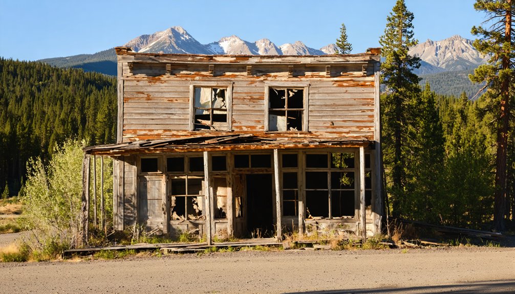
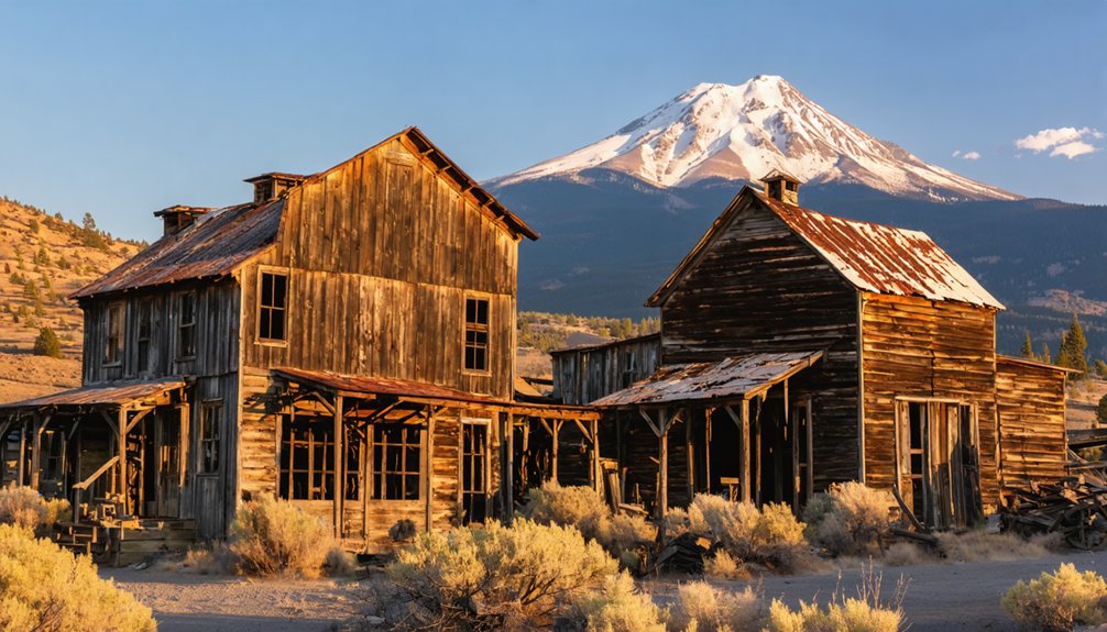
- Southern corridor sites preserve weathered cabins, stone foundations, and mining adits along CA-36/44, documenting the shift from speculative prospecting to livestock ranching.
- Northern clusters near the Nevada line showcase railroad-grade remnants and wagon-route infrastructure from early 1900s mining booms. Many settlements feature intact interiors with period furnishings and goods left behind during abandonment.
- Federal protections classify most locations as archaeological sites, prohibiting artifact removal and structural disturbance under historic preservation statutes. These sites are preserved to reflect the region’s mining heritage and settlement patterns.
You’ll navigate BLM and national forest lands where off-trail driving remains prohibited.
Although ghost town sites surround Lassen Volcanic National Park year-round, accessing them demands careful attention to elevation-dependent road closures that follow the region’s pronounced seasonal cycle.
Highway 89 through the park typically remains shuttered November through June beneath 30–40 feet of snowpack, forcing you to route around closures via lower-elevation corridors.
Unpaved approaches—Butte Lake Road, Juniper Lake Road, Warner Valley Road—become impassable mud tracks during spring thaw and remain unplowed all winter.
You’ll need to monitor Caltrans advisories for chain controls on state highways 44, 36, and 89, where sudden storms cut access entirely.
Road conditions shift rapidly: black ice forms overnight at higher passes, and soft shoulders plague April–May shifts, making flexible itineraries essential for autonomous exploration of remote historic sites.
When navigating around the park during closures, the east route spans 106 miles with an average travel time of 2 hours and accommodates RVs and trailers.
Fuel stations are limited throughout the region, with the closest options located in Shingletown, Old Station, Chester, requiring you to fill up before venturing toward remote ghost town sites.
Respecting Historic Sites: Legal Protections and Visitor Ethics
When you approach ghost towns surrounding Lassen Volcanic National Park, you’re entering legally protected landscapes governed by overlapping federal and state statutes that treat every artifact, timber frame, and rusted implement as an irreplaceable cultural resource.
The Archaeological Resources Protection Act and California Public Resources Code impose strict penalties—fines, restitution, equipment forfeiture, and jail time—for removing even square-headed nails or bottles. Legal protections empower land managers and volunteers who deploy trail cameras to document violations.
Visitor ethics demand more than compliance:
- Photograph freely, remove nothing—artifacts retain meaning only in original context
- Avoid unstable structures and mine shafts—collapse risk threatens both safety and preservation
- Stay on established routes—new tracks accelerate erosion and damage buried features
Responsible exploration sustains these sites for future generations seeking authentic encounters with frontier history.
Photography Tips for Capturing Abandoned Settlements and Mining Ruins
You’ll achieve the most dramatic images of Lassen’s ghost towns by arriving during golden hour, when oblique light rakes across weathered clapboard and rusted corrugated metal, casting long shadows that reveal every seam and buckle in decaying structures.
Focus your lens on textures that encode a century of high-elevation exposure—splintered window frames, oxidized ore-cart axles, and wind-scoured foundation timbers—to document material decay as historical evidence.
Wide-angle compositions should anchor individual artifacts or building facades within their volcanic landscape context, establishing the relationship between human settlement and the unforgiving terrain that ultimately reclaimed these sites.
Golden Hour and Shadows
Since ghost town photography demands an understanding of how transient light interacts with decaying structures, mastering golden hour techniques becomes essential for documenting the abandoned settlements scattered near Lassen Volcanic National Park.
You’ll find that the 30–60 minute window flanking sunrise and sunset transforms rust-streaked mining equipment and weathered timber into compelling visual narratives through warm color temperatures and reduced dynamic range.
Effective shadow management strategies include:
- Directional side-lighting to exaggerate texture across collapsed cabins and mining headframes, creating depth through elongated shadows
- Backlighting for silhouetting structural remnants against volcanic ridges while generating separation through rim light
- Bracketing exposures to preserve detail in both sunlit exteriors and shadowed interiors without sacrificing dramatic contrast
Strategic positioning allows you to compose layered scenes where foreground ruins fall into shadow while distant terrain remains illuminated, emphasizing abandonment’s temporal dimension.
Weathered Textures and Details
Rust blooms and splintered grain become primary storytelling elements when photographing ghost towns near Lassen, where decades of high-altitude freeze-thaw cycles and volcanic ash accumulation have accelerated material degradation in ways that differentiate these ruins from lower-elevation desert sites.
Position your camera so light rakes across weathered wood siding and corrugated panels at oblique angles, maximizing relief in grain patterns and corrosion craters.
Stop down to f/8–f/16 to maintain texture sharpness across rusted metal hardware—door latches, mining cart wheels, and nail heads—while managing the extreme contrast between dark interiors and bright window shafts.
Frame isolated artifacts tightly: peeling paint on signage, splintered timbers in collapsed roofs, crumbling masonry where volcanic dust has infiltrated mortar joints, each surface chronicling environmental forces unique to this region.
Wide-Angle Landscape Context
Wide-angle lenses between 16mm and 24mm allow you to anchor individual structures within their broader environmental matrix—the pattern of settlement that reveals how miners, sawmill operators, and railroad workers positioned their communities relative to ore veins, water sources, and transportation corridors across Lassen’s volcanic terrain.
Landscape composition strategies for environmental storytelling:
- Include foreground elements like collapsed wagon wheels or rusted mining equipment to establish depth and scale while documenting the relationship between human infrastructure and volcanic geography.
- Frame abandoned structures against distinctive Lassen landmarks—cinder cones, fumaroles, or lava flows—to contextualize why settlements emerged and ultimately failed in these geologically active zones.
- Capture the full sweep of settlement patterns showing spatial relationships between residential clusters, industrial sites, and natural resource extraction points.
This approach transforms documentation into spatial archaeology, revealing the economic and geological forces that shaped frontier communities.
Frequently Asked Questions
Are There Any Guided Ghost Town Tours Available Near Lassen Volcanic National Park?
Like a prospector searching empty diggings, you’ll find no dedicated guided tours of ghost towns near Lassen. Most historic mining settlements require self‑guided exploration, though distant Gold Rush sites occasionally offer seasonal walks emphasizing historical significance.
Can I Camp Overnight at Ghost Town Sites in Lassen County?
Overnight camping at ghost town sites is generally prohibited under federal and state cultural-resource protections. You’ll find camping regulations restrict occupancy; ghost town amenities don’t include designated campgrounds, requiring you to camp elsewhere on permitted public lands.
What Wildlife Might I Encounter While Exploring Ghost Towns Near Lassen?
Like shadows inhabiting forgotten places, you’ll encounter deer, black bears, and mountain lions within ghost town ecology. Various bird species, coyotes, and smaller mammals populate these abandoned settlements, representing wildlife species documented throughout Lassen County’s historical sites.
Are Any Ghost Towns Near Lassen Accessible for Families With Young Children?
Several sites offer limited family-friendly attractions, though ghost town safety remains challenging. You’ll find scattered ruins requiring constant supervision rather than developed interpretive centers. Hayden Hill and Susanville’s historic district provide easier access with fewer hazards for young children.
Where Can I Find Detailed Maps of Specific Ghost Town Locations?
You’ll discover ghost town history through USGS 7.5-minute quadrangles and Lassen County’s online ghost towns guide—premier mapping resources offering 1:24,000-scale detail, GPS coordinates, and downloadable geospatial PDFs for independent field navigation.
Exploring ghost towns near Los Angeles International Airport can reveal fascinating stories of bygone eras and the ghostly remnants of past communities. Many of these locations are accessible for day trips, offering a glimpse into California’s rich history as well as stunning landscapes. With proper planning and mapping tools, you can uncover these hidden gems and understand the impact of urban development on these once-thriving places.
References
- https://www.flyingdawnmarie.com/new-blog/california-ghost-towns
- https://www.parks.ca.gov/?page_id=26330
- https://nvtami.com/lassen-county-california-ghost-towns/
- https://www.weekendsherpa.com/issues/explore-ca-ghost-towns-gold-towns-and-an-underground-garden/
- https://www.npca.org/articles/821-9-spooky-national-park-sites
- https://paintyourlandscape.com/2012/10/30/the-town-that-man-could-neither-tame-nor-sustain-bodie-ca/
- https://westernmininghistory.com/library/37/page1/
- https://www.nps.gov/lavo/learn/kidsyouth/upload/Lassen-History-Timeline.pdf
- https://www.lcoe.org/Services/Events/Curriculum-Resources/Lassen-County-Timeline/
- https://www.lassencounty.org/visiting/history-lassen-county


