You’ll find Colorado’s best-preserved ghost towns in Clear Creek Canyon, just 15 miles northwest of Leadville along County Road 390. Winfield, the largest settlement, housed 1,500 residents by 1890 before the 1893 silver crash emptied it. Vicksburg earned National Register status in 1977 for its 40 remaining structures, while Beaver City retains two original 1867 log cabins. These high-elevation sites cluster together above 10,000 feet, accessible via summer roads that reveal how quickly mining prosperity turned to abandonment in Colorado’s remote mountain valleys.
Key Takeaways
- Clear Creek Canyon near Leadville contains several ghost towns from 1860s-1890s silver and gold mining camps along County Road 390.
- Winfield, the largest settlement, peaked at 1,500 residents by 1890 before the 1893 silver crash caused abandonment.
- Vicksburg, established in 1867, is well-preserved with original buildings and listed on the National Register of Historic Places.
- Beaver City, founded in 1867, was the first mining camp with two original log cabins still standing today.
- Access requires high-clearance vehicles on unpaved roads at 10,000+ feet elevation; best visiting period is late June through September.
Clear Creek Canyon’s Historic Mining Heritage
When prospectors pushed up Clear Creek Canyon between Leadville and Buena Vista in the early 1880s, they transformed a remote alpine corridor into a network of silver and gold camps strung along what’s now County Road 390.
Placer and lode discoveries in the Sawatch Range triggered rapid settlement—miners built log cabins, boarding houses, and saloons wherever claims showed promise. These communities relied on Clear Creek for water power and ore transport, with mining techniques evolving from simple panning to hard-rock operations at sites like the Tasmania, Swiss Boy, Fortune, and Banker mines. After placer gravels were exhausted, hard rock mining became the predominant method of extraction throughout the region.
Declining ore grades and metal-price crashes emptied the camps by the early 1900s. Once resources were depleted, settlers abandoned these towns, leaving behind the structures that visitors explore today.
Today, ghost town preservation efforts maintain landmarks like Vicksburg’s museum and Crescent City’s rentable cabins, offering you direct access to this boom-and-bust legacy.
Winfield: The Canyon’s Largest Settlement
At the junction of Clear Creek’s north and south forks, Winfield emerged as the canyon’s largest and most developed mining settlement, growing from a single cabin built in 1861 to a platted town of 1,500 residents by 1890.
You’ll find evidence of sophisticated mining techniques throughout the district, where ore was processed at local concentrators before wagon transport to railroad connections in Granite.
The town demographics reflected a diverse, working community—three saloons, three general stores, two hotels, a boarding house, church, and schoolhouse served miners and families alike.
Free 50×100-foot lots accelerated development across the 120-acre townsite.
The 1893 silver crash devastated operations, closing the post office by 1912.
Mining activities ceased in the early 1900s, marking the transition from a bustling commercial center to a ghost town.
Today you can explore preserved structures including the 1889 schoolhouse within San Isabel National Forest. Historical displays are visible through the schoolhouse window, offering glimpses into the daily life of this once-thriving mining community.
Vicksburg: A Well-Preserved Mining Community
Gold seekers from Leadville established Vicksburg in 1867 when their lost burros stopped along Clear Creek, revealing rich ore deposits that would transform the location into a multi-metal mining community.
Understanding Vicksburg history means recognizing how this mining community grew to 600–700 residents and 40 buildings by 1880, supported by essential services including schools, hotels, assay offices, and stagecoach connections.
You’ll discover miners planted double rows of Balm of Gilead trees along the main street—packed in on burros—creating irrigation ditches from Vicksburg Creek for fire protection and domestic use. The resin gum extracted from these Balm of Gilead trees served as a valuable healing compound for the mining community.
The National Register of Historic Places recognized this settlement in 1977, and you’ll find it remains one of Colorado’s better-preserved ghost towns, with standing cabins documenting authentic frontier planning. A historical society formed in 1971 for protection of the ghost town’s integrity, focusing on maintaining historical buildings and artifacts while engaging the community in education and tourism.
Beaver City: The Canyon’s First Mining Camp
You’ll find Beaver City holds the distinction of being Clear Creek Canyon’s first mining camp, established in 1867 when prospectors discovered gold in the creek bed.
Of the original twenty buildings that comprised this pioneering settlement, only two structures remain standing today as physical evidence of the canyon’s earliest habitation.
The site’s transformation into a ghost town followed the consolidation of mining operations toward larger claims like the Tasmania, Fortune, and Banker, mirroring the shift from independent miners to corporate syndicates that characterized Leadville’s broader mining evolution.
The surrounding Leadville mining district features over 2,800 patented mine claims, reflecting the extensive mineral extraction that drew prospectors throughout the Colorado Mineral Belt during the silver boom era.
Canyon’s Earliest Settlement History
When prospectors pushed into Clear Creek Canyon during the 1860s, they established Beaver City as the canyon’s first mining camp—a modest settlement along lower Clear Creek that would anchor the region’s earliest mineral exploration.
You’ll find this site predated Vicksburg, Rockdale, and Winfield, serving as the logistical nucleus where miners refined mining techniques from placer work to systematic lode exploration.
The camp’s twenty-odd buildings housed crews working nearby hillsides and creek gravels, building infrastructure that enabled upstream discoveries.
As richer strikes materialized farther into the canyon, capital and labor migrated toward more productive ground.
Beaver City’s economic decline came swiftly—its role as staging point evaporated once better ore bodies and extended transport routes rendered the lower-canyon camp obsolete in the competitive silver rush economy.
The settlement’s workforce reflected the ethnic diversity common to Colorado mining camps, with communities forming along national lines similar to those found in coal towns throughout the region.
Today, the area serves outdoor enthusiasts who travel Clear Creek Canyon Road to access campgrounds and boondocking sites near Winfield.
Remaining Original Structures
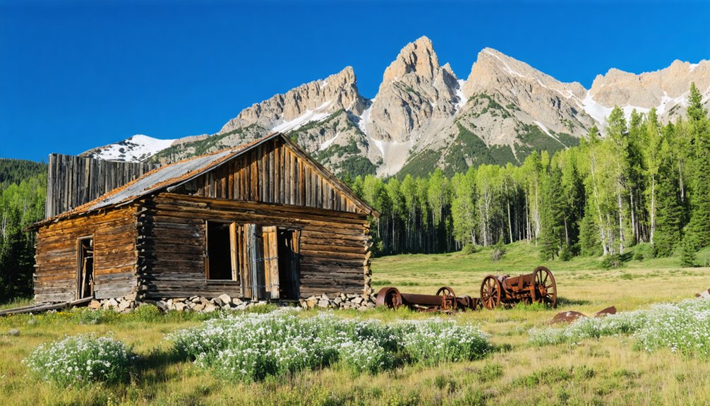
Despite the complete abandonment of Beaver City’s commercial and residential core, two original log cabins still stand along County Road 390, representing barely ten percent of the camp’s estimated twenty historic structures.
You’ll find these remaining buildings weathered but intact, their hewn timber walls darkened by over a century of high-elevation exposure to snow and freeze-thaw cycles. The architectural integrity is ruinous to fair—wall logs retain structural soundness while roofs and openings show partial loss or expedient repairs.
These simple rectangular cabins exemplify frontier construction: horizontal log walls with corner notching, locally sourced conifer timber, and utilitarian design devoid of ornamentation.
Surrounding clearings, ground disturbances, and debris scatters mark former building pads, letting you trace the original camp layout across a landscape now reclaimed by encroaching vegetation.
Location and Visitor Access
Located approximately 12 miles southwest of Leadville along County Road 390, Beaver City occupies a position deep within Clear Creek Canyon that made it the first mining settlement prospectors encountered when traveling into this rugged ore-producing district.
Today’s ghost town dynamics present you with two surviving structures from the original twenty buildings that housed miners and merchants during the 1870s boom years. You’ll find the site accessible year-round, though winter conditions can make navigation challenging along canyon roads.
Visitor experiences emphasize self-guided exploration of the settlement’s footprint, where you can trace the layout of claims that once supported the Tasmania, Fortune, Banker, and Swiss Boy operations.
The canyon’s natural terrain remains largely unchanged, offering authentic glimpses into the environmental conditions early prospectors confronted while establishing this remote mining outpost.
Rockdale: Remote Cabins and Mining Remnants
Pushing deeper into Clear Creek Canyon beyond Vicksburg, you’ll find Rockdale roughly two miles farther along County Road 390, where beaver ponds have swallowed much of the original 1881 mining camp.
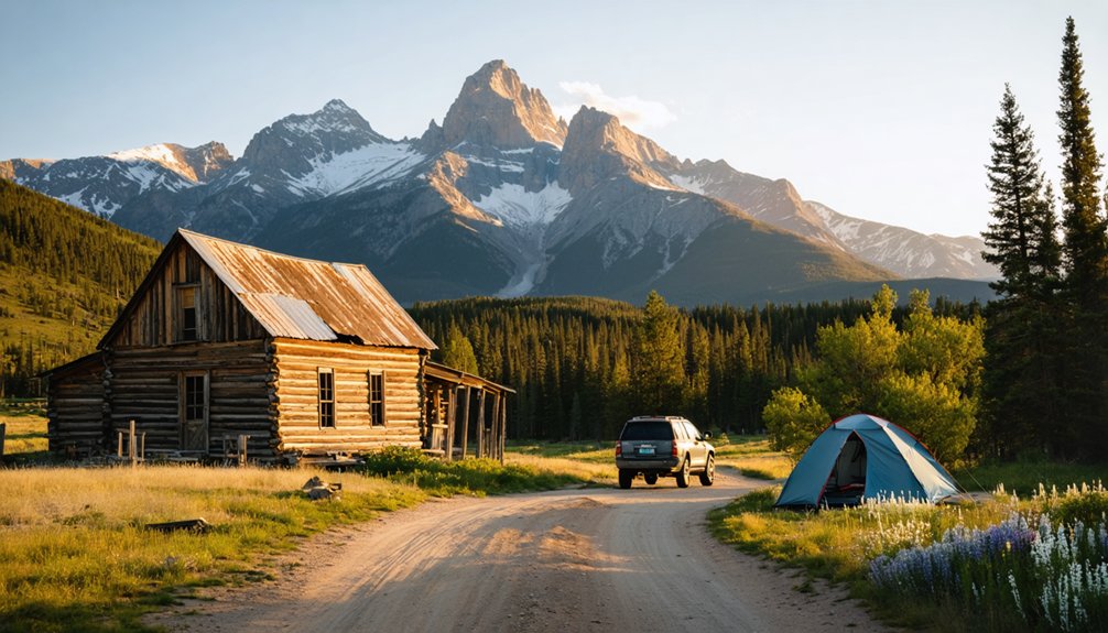
Four restored log cabins mark the site today, with at least two confirmed as original Rockdale structures relocated within the Crescent Mining Camp complex.
The Forest Service rents these rustic shelters—no electricity, no plumbing, no drinking water—allowing you to experience the canyon’s isolation much as silver-era miners did in the early 1880s.
Original Mining Cabin History
Inside, mining culture prioritized bunk space and heat over comfort, mirroring patterns seen at Winfield and Vicksburg.
Rockdale functioned as a small satellite between those larger centers, never reaching Winfield’s 1,500-resident scale.
Today it’s a ghost town with authentic fabric intact, offering you tangible evidence of Colorado Mineral Belt life.
Accessing Rockdale’s Remote Location
Chaffee County Road 390 threads through Clear Creek Canyon between Buena Vista and Leadville, delivering you to Rockdale’s hillside perch near the confluence of Clear Creek and Lake Fork Creek.
This unpaved gravel route demands attention to road conditions—dry weather leaves it passable for high-clearance rigs, but wet spells breed mud and ruts that challenge traction and ground clearance.
Vehicle requirements favor 4WD beyond the maintained lower segments, particularly as you push deeper into the canyon’s upper reaches.
Snowpack and spring runoff impose seasonal constraints, rendering sections impassable before summer thaw.
Narrow alignment and steep canyon walls restrict turn-around space and passing zones, requiring controlled speed through blind curves.
At 9,000–9,500 feet elevation, you’ll face rapid weather shifts and minimal cellular coverage—bring paper maps, offline navigation, and self-sufficiency for fuel and provisions.
Planning Your Visit: Access and Camping Information
Because the ghost towns near Leadville sit at elevations near or above 10,000 feet, planning your visit requires attention to seasonal conditions, vehicle capability, and high-altitude preparedness.
County Road 390 to Clear Creek Canyon’s sites—Beaver City, Vicksburg, Rockdale, and Winfield—remains suitable for 2WD passenger vehicles during dry summer months, though high-clearance helps during mud season.
Oro City’s access via County Road 39 offers year-round 2WD capability. Late June through September provides ideal weather conditions for exploring upper elevations, while afternoon thunderstorms demand early starts for road safety.
Camping options include the developed Clear Creek Reservoir campground and numerous free dispersed sites along CR 390.
Pack all supplies; these remote townsites lack fuel, food, and reliable cell coverage, requiring self-sufficiency and adherence to Forest Service regulations.
Frequently Asked Questions
Are the Ghost Towns Accessible During Winter Months?
Winter’s white curtain bars most ghost towns near Leadville—roads become impassable snowfields above 10,000 feet. You’ll need snowshoes or skis for winter accessibility, though road conditions close vehicle routes until spring thaw arrives.
Can You Camp Overnight Directly at the Ghost Town Sites?
No, you can’t camp overnight directly at most ghost town sites due to camping regulations on private mining claims and historic districts. Proper ghost town etiquette means using nearby designated campgrounds and respecting fragile ruins.
Are There Guided Tours Available for the Ghost Towns?
Yes, you’ll find guided explorations through local outfitters combining ghost-town stops with 4×4 trips, plus evening lamplight walks offering historical insights into Leadville’s 1880s mining heritage. Vicksburg and Winfield provide weekend docent-led interpretation seasonally.
Is It Legal to Take Artifacts From the Ghost Towns?
No, you can’t legally take artifacts from ghost towns. Federal and state laws protect items of historical significance on public lands, emphasizing artifact preservation. Removing objects from private property constitutes theft, regardless of a site’s abandoned appearance.
What Wildlife Might Visitors Encounter in Clear Creek Canyon?
You’ll encounter diverse wildlife species in Clear Creek Canyon’s ecosystem, including bighorn sheep on cliffs, elk and mule deer in meadows, black bears in forests, beavers along waterways, raptors overhead, and abundant trout in the creek.
References
- https://www.uncovercolorado.com/vicksburg-winfield-ghost-towns/
- https://www.colorado.com/articles/colorado-ghost-towns
- https://www.longmontleader.com/colorado/explore/20-must-visit-ghost-towns-in-colorado-for-an-eerie-adventure-10192944
- https://www.islands.com/2061852/colorado-abandoned-ghost-towns-once-thriving/
- https://www.leadvilletwinlakes.com/blog-ghosts-of-leadville-colorado/
- https://www.americansky.co.uk/colorado-holidays/exploring-colorados-ghost-towns
- https://ruralresurrection.com/ghost-towns-gilman-colorado/
- https://www.atlasobscura.com/things-to-do/colorado/abandoned
- https://www.clearcreekcounty.us/1538/Mining
- https://leadville.com/the-ghost-towns-of-leadville-and-beyond/


