
You’ll find ghost towns clustered within two-hour travel corridors of major airports across North America and Europe. Pennsylvania’s Centralia sits 95 miles from Philadelphia International, while Spain’s submerged villages like Aceredo connect through regional hubs. Chicago O’Hare provides access to Indiana’s industrial ruins, and Mediterranean resorts like Varosha in Cyprus remain accessible despite military restrictions. These sites operate under specific regulatory frameworks—from archaeological protections to military exclusion zones—that govern visitor access. The following sections detail transport logistics, legal boundaries, and documentation protocols for responsible exploration.
Key Takeaways
- Centralia, Pennsylvania is 95 miles from Philadelphia International Airport, accessible within two hours despite active coal fire hazards.
- Ghost Town Trail connects eight abandoned mining communities near Pittsburgh International Airport, offering controlled historical site access.
- Varosha, Cyprus and Kupari, Croatia are prominent ghost resorts located near major airports but remain under military control.
- Goussainville-Vieux Pays deteriorated after Charles de Gaulle Airport construction, exemplifying aviation infrastructure’s impact on nearby settlements.
- Abandoned airport terminals like Pittsburgh’s 1992 complex and Denver’s Stapleton tower represent unique ghost sites within urban areas.
Defining Accessibility: What Makes a Ghost Town “Near” a Major Airport
When evaluating which ghost towns qualify as “near” a major airport, distance alone proves insufficient—travel time, connectivity, and regulatory influence provide far more accurate measures of proximity.
You’ll find transport studies define “near” as 30–60 minutes from terminals, while urban-planning practice sets a 15–20 km land‑use influence zone.
Travel accessibility through direct highways, transit corridors, or shuttle networks matters more than straight-line mileage—a site with multi‑modal connections reaches you faster than a closer location blocked by terrain.
Connectivity trumps distance—a well-linked distant site outperforms a closer location hampered by geographic barriers.
Regulatory zones complicate the picture: noise contours, safety buffers, and height restrictions create functional nearness regardless of distance.
Former neighborhoods caught in runway expansion or buyout programs exemplify urban decay tied directly to aviation infrastructure, qualifying them as “near” through operational entanglement rather than geography.
Historical cases show how changes in aviation technology necessitated runway extensions that engulfed previously distant residential areas.
Successful redevelopment of these sites requires proximity to population centers and mass transit accessibility to transform abandoned areas into viable urban spaces.
Pennsylvania’s Abandoned Communities Within Reach of East Coast Hubs
Pennsylvania’s ghost towns cluster within a two-hour radius of Philadelphia International (PHL) and Lehigh Valley International (ABE), forming a documented corridor of industrial-era abandonment governed by federal mine safety regulations, EPA monitoring protocols, and state historic preservation mandates.
You’ll access Centralia’s coal-fire zone 95 miles from PHL under active subsidence warnings, while Pithole’s 1860s petroleum site operates as a controlled archaeological district requiring compliance with cultural resource protection standards.
Each location functions within distinct regulatory frameworks—environmental remediation orders at Centralia, heritage tourism permits at Eckley, and nuclear facility buffer-zone restrictions at Frick’s Lock—that determine visitor access, liability boundaries, and preservation funding streams.
The Ghost Town Trail’s 46 miles of crushed limestone pathway connects eight abandoned coal mining communities in Indiana and Cambria Counties, accessible via Pittsburgh International Airport.
Submerged towns like Somerfield under Youghiogheny River Lake occasionally emerge during drought conditions, revealing foundations partially exposed in 1999.
Centralia’s Underground Coal Fire
Beneath what remains of Centralia, Pennsylvania, a coal seam fire has burned continuously since May 1962, when municipal waste disposal operations near the Independent Order of Odd Fellows Cemetery ignited coal residues within a network of abandoned mine tunnels.
The underground fires now span 3,700 acres at depths reaching 300 feet, advancing 75 feet annually along four separate branches. Toxic emissions including sulfurous fumes and carbon monoxide forced the abandonment of a town that once housed 3,000 residents.
After bureaucratic delays stalled containment efforts—a proposed trench excavation came four years too late—state authorities condemned the entire municipality in 1992. You’ll find fewer than ten holdouts remaining despite revoked postal service.
Coal burns slowly and steadily, unlike the rapid combustion seen in surface fires, allowing the Centralia blaze to persist with minimal visible flame. Temperatures exceeding 1,000°F have been recorded in the burning coal seams below ground.
Projections indicate another 250 years of burning at current rates.
Pithole’s Oil Boom Legacy
Fifteen thousand fortune-seekers transformed farmland into Pennsylvania’s third-busiest post office within six months of the May 1865 Holmden Farm strike, creating what remains North America’s most documented boom-and-bust oil settlement.
You’ll find Pithole heritage preserved through a 200-building diorama at the Drake Well Museum’s visitor center, reconstructing the 54 hotels and 1,100-seat theater that served daily transactions exceeding tens of thousands of dollars.
Oil speculation collapsed after 17 major fires destroyed $2 million in assets and regional bank failures in March 1866 triggered a 90% population exodus by December.
The 1877 charter revocation formalized what 500 days of unregulated extraction had accomplished—complete abandonment.
The Pennsylvania Historical and Museum Commission owns the site, which appears on the National Register of Historic Places as a testament to rapid resource extraction.
Today’s interpretive trails follow original street grids where 5,000 barrels once flowed daily, accessible from Pittsburgh International within two hours. Mowed paths now represent the once-busy streets where grand hotels, saloons, and businesses once stood before nature reclaimed the abandoned settlement.
Yellow Dog Village Tours
While most industrial ghost towns vanished through demolition or natural decay, Yellow Dog Village persists under controlled private ownership as a 40-structure company town museum near Worthington, Armstrong County—90 minutes northeast of Pittsburgh International Airport.
You’ll access yellow dog tours through scheduled open houses and photography events run by preservationists who acquired the 1915–1925 limestone mining settlement. The fee-based system restricts spontaneous exploration but enables ghost town experiences unavailable at razed sites—intact workers’ houses, a chapel, boarding facilities, and the manager’s residence frozen mid-abandonment after 2012’s water-system collapse.
Current owners plan overnight stays in restored homes offering constrained-utility living (battery lighting, bottled water) mimicking 1920s conditions. The village’s streets remained unnamed throughout its operational history, maintaining an informal structure that included an unofficial mayor. A baseball field and playground with a pavilion named after Daniel M. Fileleti serve as community gathering spaces within the preserved settlement. This private-access model balances decay prevention against controlled visitor freedom, converting anti-union labor history into experiential heritage tourism.
European Villages Frozen in Time: From Spanish Reservoirs to British Military Zones
Across the European landscape, administrative decisions and infrastructure projects have produced a distinct category of ghost settlements where state power—whether exercised through reservoir construction, military requisition, or aviation expansion—has overridden traditional property rights and community continuity.
You’ll find these displacement patterns follow three regulatory mechanisms:
- Hydroelectric eminent domain: Spanish villages like Mediano (1974) and Aceredo (1992) vanished beneath reservoirs, their submerged histories surfacing only during droughts when forgotten memories emerge as stone walls and church spires.
- Military zone permanence: British villages Imber and Tyneham remain evacuated since 1943, with access limited to designated open days under Ministry of Defence control.
- Aviation-driven abandonment: Goussainville-Vieux Pays deteriorated after Charles de Gaulle Airport construction, intensified by the 1973 Tu-144 crash that killed residents.
Mediterranean Ghost Resorts Accessible From Modern Aviation Gateways

You’ll find two of the Mediterranean’s most documented ghost resorts—Varosha in Northern Cyprus and Kupari in Croatia—each positioned within 60 km of major international airports serving millions of annual passengers.
Both complexes showcase mid-century concrete hotel blocks abandoned after armed conflict, now subject to overlapping military restrictions, disputed ownership claims, and heritage-protection frameworks that complicate redevelopment despite their transport accessibility.
Varosha’s 45-hotel district near Larnaca Airport remains partially fenced under Turkish Cypriot military control since 1974, while Kupari’s seven war-damaged resorts lie 20 km south of Dubrovnik Airport within a contested restitution process involving multiple former Yugoslav state enterprises.
Varosha’s Frozen Beach Towers
Famagusta’s Varosha district held 45% of Cyprus’s hotel bed capacity by the early 1970s, positioning it as the island’s dominant tourism engine before military conflict transformed it into the Mediterranean’s most extensive militarized ghost resort.
Varosha’s history demonstrates how geopolitical intervention can freeze economic assets indefinitely. The 1974 Turkish military action locked thousands of property owners from their holdings, converting productive hospitality infrastructure into a restricted military zone.
Understanding the tourism impact requires examining three structural realities:
- Economic concentration: Tourism from Varosha/Famagusta contributed approximately 57% of Cyprus’s GDP by 1970.
- Infrastructure loss: Five kilometers of beachfront hotels—including the Argo, King George, and war-damaged Salaminia Tower—remain vacant.
- Property dispossession: Multi-billion-dollar investments became inaccessible, creating decades-long legal disputes over ownership rights.
Kupari’s War-Damaged Hotels
Ten kilometers southeast of Dubrovnik Airport, Kupari’s seven war-damaged hotels represent the Mediterranean’s most accessible ghost resort, where Yugoslav military infrastructure worth half a billion euros (in present-day terms) remains frozen since 1991 shelling operations.
You’ll find Grand, Goričina I and II, Kupari, Pelegrin, Mladost, and Galeb—1,600-bed facilities purpose-built for Yugoslav People’s Army officers—now stripped of copper, wiring, and fixtures after systematic looting.
The complex demonstrates how territorial conflict transforms regulated military holiday zones into uncontrolled ruins. Croatian forces briefly repurposed these Kupari hotels post-war before complete abandonment enabled unrestricted access.
Today’s regulatory vacuum persists: no demolition permits enforced, no reconstruction framework implemented, no trespass restrictions applied.
War ruins visible from Dubrovnik’s viewpoints draw international visitors through established aviation corridors, creating an unregulated tourism layer beyond conventional resort licensing systems.
Midwest Industrial Ruins and Resource Towns Reachable From Chicago O’hare
Within an hour’s drive of O’Hare, the Calumet Region steel corridor and northwest Indiana industrial belt present some of North America’s most concentrated post-industrial landscapes—600-acre mill sites, abandoned ore docks, and entire neighborhoods built to house vanished workforces.
You’ll find unrestricted access varies greatly across parcels marked for redevelopment but still exhibiting urban decay amid ongoing remediation proceedings.
Three accessible industrial heritage zones:
- U.S. Steel South Works site – 600 acres of lakefront ruins, former employer of 20,000 workers
- Gary Works perimeter – derelict housing blocks, shuttered satellite plants serving 175,000 peak population
- Joliet Correctional Center – 1858 limestone penal complex with intact cellblocks and power infrastructure
Environmental contamination designation requires checking EPA brownfield databases before site entry.
Most locations remain under state jurisdiction pending rezoning or demolition permits.
When Airports Become Ghosts: Abandoned Terminals Near Active Hubs
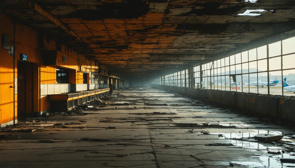
Unlike factory ruins that decay incrementally over decades, entire airport terminals can fall silent overnight when regulatory bodies authorize successor facilities—leaving multi-hundred-million-dollar infrastructure stranded within sight of active runways.
Pittsburgh’s 1992 X-shaped complex—$780 million and twice downtown’s footprint—sits idle beside the 2025 terminal, its abandoned runways paralleling commercial traffic.
Seven hundred eighty million dollars of infrastructure rendered obsolete while jets taxi past its vacant corridors toward replacement gates.
Denver preserved Stapleton’s 164-foot control tower when DEN opened in 1995, transforming airfield into neighborhoods while the relic marks where six runways once served hub operations.
Hong Kong’s Kai Tak closure in 1998 left terminal relics and runway traces in Kowloon Bay, 30 km from Chek Lap Kok’s modern gateway.
You’ll find these ghost terminals maintained under aviation safety protocols yet stripped of the passenger flows that justified their construction—regulatory artifacts of miscalculated demand.
Conflict and Evacuation: Military Ghost Sites Linked to Major Air Travel Routes
Commercial aviation’s regulatory frameworks let terminals go dark when demand models fail, but military installations vanish from the map through closure orders that dismantle entire support ecosystems overnight.
You’ll find these military evacuations create sprawling ghost zones where Cold War infrastructure once intersected civil air corridors.
Three patterns define air travel conflicts near abandoned military complexes:
- Roosevelt Roads Naval Station (Puerto Rico) closed in 2004, leaving 8,600 acres of derelict airfield, housing, and contaminated sites near San Juan’s approach paths.
- March Air Force Base (California) downsized in 1996, producing 4,500 acres of abandoned structures—including 588 houses and hospitals—alongside active KC-135 and C-17 operations.
- Sierra Village (Fresno) saw 88 homes demolished under FAA safety zones when runway extensions pushed residents into crash risk corridors.
These evacuations strip buffer zones between military flight operations and civilian development.
Planning Your Visit: Travel Logistics and Exploration Guidelines

Before you plan any field research to airport-adjacent ghost towns, you’ll need to understand that FAA security protocols and active runway operations create legal barriers that make traditional exploration impossible at most sites.
Ghost town accessibility remains severely restricted—fencing surrounds Sierra Village near Fresno Yosemite International, while Surfridge near LAX exists entirely within controlled airport property.
Your urban exploration guidelines must prioritize legal alternatives: document from public roadways, access historical markers where available, and utilize local historical societies’ archives for research.
The hidden-in-plain-sight positioning of these sites allows peripheral observation, though you can’t enter restricted zones.
Focus your efforts on visual documentation points along perimeter fences, review online databases cataloging specific locations, and examine government records detailing displacement timelines rather than risking trespassing violations.
Frequently Asked Questions
Are Ghost Town Visits Safe for Families With Young Children?
Ghost town safety risks—unstable structures, unmarked shafts, contamination, and delayed emergency access—make most sites unsuitable for young children. You’ll find safer family-friendly activities at managed heritage parks with maintained infrastructure, marked hazards, and nearby medical facilities.
Which Ghost Towns Allow Overnight Camping or Accommodation Nearby?
You’ll find campground options directly inside Bannack State Park and Calico Ghost Town, while Bodie requires nearby lodgings off-site. Holy Ghost Campground and Donner Memorial State Park both offer on-location camping with standard amenities.
Do I Need Special Permits to Photograph Abandoned Buildings?
“Better safe than sorry”: you’ll need permits for commercial photography on public land and federal property. Even abandoned buildings require owner permission. Urban exploration and photography ethics demand respecting trespassing laws to protect your freedom.
What Seasonal Weather Conditions Affect Ghost Town Accessibility?
You’ll encounter weather patterns like winter snow blocking mountain roads, monsoon flash floods washing out desert tracks, and wildfire smoke triggering seasonal closures—each limiting your access windows despite operational airports nearby.
Are Guided Tours Available or Must I Explore Independently?
You’ll find an overwhelming abundance of choices—many ghost towns offer both guided exploration through heritage sites and self-guided tours via interpretive trails, letting you pick ranger-led programs or roam freely on signed loops.
Explorers searching for ghost towns near Regina Saskatchewan can delve into the rich history and stories of the area. Many of these towns feature remnants of their past, such as old buildings, artifacts, and unique landscapes that tell tales of the people who once inhabited them. Whether you’re interested in photography, history, or simply enjoying the outdoors, these locations provide a fascinating glimpse into a bygone era.
References
- https://en.wikipedia.org/wiki/List_of_ghost_towns_by_country
- https://uncoveringpa.com/ghost-towns-in-pa
- https://www.loveexploring.com/gallerylist/68174/abandoned-hotels-and-airports-you-wont-want-to-check-into
- https://www.frrandp.com/p/other-maps.html
- https://www.atlasobscura.com/lists/abandoned-places-midwest
- https://christinenegroni.com/its-ghost-town-at-airports-on-northeas/
- https://www.weforum.org/stories/2023/09/abandoned-airports-urban-regeneration/
- https://www.kvpr.org/podcast/central-valley-roots/2025-03-11/in-fresno-a-ghost-town-sits-near-the-end-of-this-airport-runway
- https://en.wikivoyage.org/wiki/Ghost_towns
- https://westernmininghistory.com/664/what-is-a-ghost-town-wmh-town-classifications-explained/


