You’ll find some of California’s most authentic Gold Rush ghost towns within 25 miles of Mariposa, including Hornitos with its granite jail and outlaw legends, Bear Valley where Colonel Frémont’s adobe ruins still stand, and Agua Fria, the county’s first seat of government. Indian Gulch’s pioneer cemetery and Quartzburg’s mining remnants tell stories of the forty-niners who shipped thousands in gold daily. Bagby’s streets now lie beneath Lake McClure, drowned by the 1967 dam. Each settlement offers distinctive ruins, cemeteries, and historical markers that reveal deeper layers of pioneer history.
Key Takeaways
- Hornitos features authentic outlaw legends, a granite-walled jail, and a central plaza reflecting its Mexican heritage and gold rush peak.
- Bear Valley contains ruins of Frémont’s headquarters, rock-walled jail cells, and the historic I.O.O.F. Hall dating from 1862.
- Quartzburg established influential mining claim regulations and housed the Big Blue mine, which extracted $1.8 million in gold.
- Coulterville preserves authentic heritage including the Hanging Tree, Jeffery Hotel, and remnants of a Chinese settlement despite three fires.
- Bagby was submerged in 1967 by Lake McClure after New Exchequer Dam construction; its streets now lie underwater.
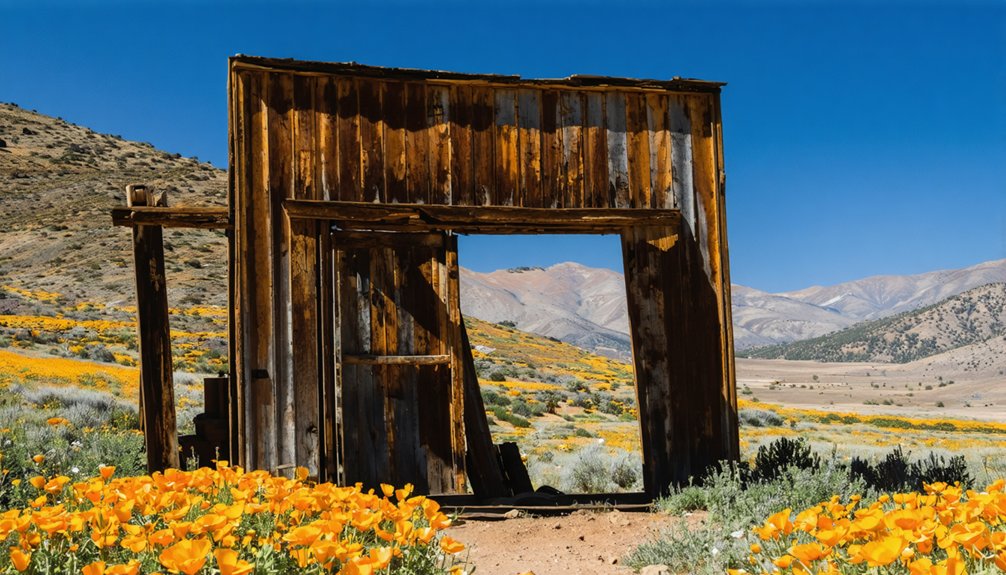
Hornitos: The Outlaw Town That Time Forgot
Hornitos earned its name—Spanish for “little ovens”—from the dome-shaped bake ovens German settlers built or the above-ground graves that dotted the hillsides like clay beehives.
Above-ground graves dotted the hillsides like clay beehives, giving Hornitos its haunting name—Spanish for “little ovens.”
You’ll find California’s most authentic outlaw legends here, where Joaquín Murrieta once vanished through underground tunnels connecting fandango halls. During the 1850s boom, fifteen thousand souls packed this Mexican camp-turned-boomtown, shipping $40,000 in gold daily while mining culture flourished in thirty-six saloons.
The granite-walled jail still stands, a reminder of lynchings and knife duels that made Hornitos the roughest camp in Mariposa County. Wells Fargo opened its first county office here in 1852.
Today, you’ll walk stone ruins along one dusty street, discovering the Ghirardelli store that funded a chocolate empire and freedom’s price in gold. The town’s central plaza remains a testament to the Mexican influence that shaped Hornitos when it was established after miners were driven from Quartzburg. For over fifty years, the community celebrated annual religious customs that reflected Old Mexico traditions, blending Mexican heritage with California’s mining frontier.
Indian Gulch: Hidden Ruins and Pioneer Graves
Just eight miles northeast of Hornitos, another settlement rose and fell with equal drama but left far less behind.
Indian Gulch—first called Santa Cruz by Mexican miners in 1849—thrived as a supply center until its post office closed in 1912.
Today you’ll find its hidden history scattered across private ranchland: foundations beneath oak trees, a cemetery on the hill, and silence broken only by cattle and coyotes.
That graveyard tells the real story.
Headstones bear names from Mexico, Italy, France, Germany, and the Azores—a pioneer legacy carved in stone.
Among those buried there are the children of Antonio Chichizola, a reminder of the families who made this remote gulch their home.
A small Catholic church stood here from 1885 until it was moved to Mariposa in 1973, only to burn seven years later.
The crumbling Solari Store, one of only two structures remaining from the town’s bustling era, still stands along the road.
An E Clampus Vitus plaque marks the entrance, honoring those who built something remarkable, then vanished.
Agua Fria: Mariposa County’s Lost Administrative Heart
You’ll find Agua Fria’s story woven into the very foundations of Mariposa County—this cold-water creek settlement served as the region’s first county seat from February 1850 to November 1851, administering an enormous territory that once covered one-sixth of California.
Sheriff James Burney ran the county’s law enforcement from his cabin-turned-jail while log buildings housed the earliest court proceedings in the new state.
By Fall 1850, the booming camp featured around a dozen stores alongside numerous tents, log cabins, and even a billiard room and bowling alley.
Agua Fria served as a popular destination for gold seekers in the early Gold Rush days, drawing prospectors to its placer deposits along the creek.
Today, you can trace what remains of this administrative hub along Agua Fria Creek, about three miles west of modern Mariposa near Highway 140, where scattered artifacts and landscape features mark where county government first took root in the southern Mother Lode.
Early County Seat Status
Few settlements in California’s early statehood can claim the administrative distinction that Agua Fria held during those formative months of 1850 and 1851.
You’ll discover this remote mining camp served as Mariposa County‘s first seat of government—a territory comprising one-sixth of California’s landmass. The historical significance of this designation can’t be overstated: early legal proceedings of the new state unfolded here among miners and merchants.
For twenty-one months, Agua Fria wielded administrative authority over what would become six modern counties.
Its mining legacy attracted settlers who built a dozen stores, gaming halls, and civic facilities to support the burgeoning community. Mariposa County was one of the original 27 counties established in California.
The community was established by Sonoran miners who recognized the area’s mineral potential and access to fresh water sources.
When Mariposa claimed the county seat in 1852, Agua Fria’s political importance vanished, setting the stage for its eventual abandonment.
Remnants and Access Today
Unlike many California gold camps that left stone walls or crumbling facades, Agua Fria vanished so completely that you’ll find only a grass-covered clearing where Mariposa County’s first government once operated.
The 1866 fire consumed seventy-five buildings in one sweep, and residents—never owning the land beneath their feet—simply moved on rather than rebuild.
Today, California Historical Landmark No. 518 marks the site along Highway 140, about three miles west of Mariposa.
You can pull off near the roadside marker, though exploring further means traversing private property boundaries.
The historical significance remains documented through county archives and period newspapers, but the physical townsite offers little beyond subtle ground disturbances near Agua Fria Creek—traces only experts would recognize as mining-era activity.
The Mariposa Gazette reported the blaze originated in the Chinese church, with investigators suspecting incendiary causes as flames spread rapidly through the combustible structures.
The actual camp site sits about one-fourth mile off Highway 140 via Agua Fria Road, though the roadside monument does not mark the exact original location.
Bear Valley: Adobe Walls and Gold Rush Memories
When Mexican miners struck gold at Bear Valley in 1850, they pulled an estimated $250,000 from the placers in just a few weeks—a discovery that transformed a remote Sierra foothill canyon into one of Mariposa County’s most important settlements.
You’ll find Bear Valley’s mining legacy etched into every adobe wall and stone foundation still standing today.
Colonel John C. Frémont made this his headquarters for the 44,000-acre Rancho Las Mariposas, creating a quasi-feudal empire where 3,000-5,000 residents worked his Pine Tree and Josephine mines.
Walk among the ruins and you’ll discover:
- Rock-walled jail cells holding centuries of secrets
- BonTon Saloon where Chinese, Cornish, and Mexican miners gathered
- Trabucco Store foundations marking the commercial heart
- I.O.O.F. Hall standing since 1862
- Adobe remnants of Frémont’s company town
Bagby: The Town Drowned by Progress

The inundation impact came swiftly in 1967 when New Exchequer Dam created Lake McClure.
Yosemite officials salvaged the station, turntable, and water towers before bulldozers razed everything else.
Now you’re free to boat over Bagby’s submerged streets—progress demanded its sacrifice.
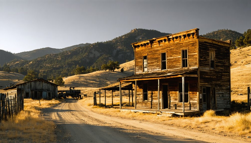
Coulterville: Where History Still Lives and Breathes
While Bagby disappeared beneath the reservoir’s waters, Coulterville clung to the hillsides and survived—battered by three catastrophic fires twenty years apart, yet stubbornly rebuilt each time.
You’ll find authentic Coulterville heritage preserved in streets where 3,000 miners once sought fortunes. The 1899 fire’s rubble, dumped as road fill, sparked the town’s most unusual Gold Rush tales when winter rains exposed hidden gold coins, sending residents frantically tearing up the streets.
Walk past landmarks that refuse to fade:
- The weathered Hanging Tree, where Leon Ruiz met frontier justice in 1856
- Jeffery Hotel’s three stories, standing since 1851
- Mary Harrison Mine’s legacy, producing gold until 1903
- Chinese settlement remnants marking multicultural beginnings
- Barrett blacksmith shop, forging community through changing eras
This California Historical Landmark remains defiantly alive.
Mount Bullion and Mormon Bar: Twin Relics of the Southern Mines
North of Mariposa along Highway 49, you’ll find Mount Bullion’s scattered ranches and tailings piles marking what was once a bustling supply center for Frémont’s Las Mariposas mining district.
Just south of town, Mormon Bar’s placer grounds tell a quieter story of Latter-day Saint miners who worked these bars before moving on.
Both sites preserve fragments of their mining past—altered creek channels, historic road alignments, and the occasional foundation—inviting you to piece together their rise and fade from the landscape itself.
Mining Heritage and Ruins
Today’s ruins reveal:
- Princeton Mine’s 1,350-foot shaft—Mariposa County’s deepest hard-rock working, producing nearly $5 million in gold
- Mormon Bar’s extensive Chinese quarter—stone foundations, hand-built terraces, and opium den cellars
- Scattered arrastra rings and stamp mill foundations documenting technological evolution
- Granite quarry scars where Mormon Bar supplied county jail construction stone
- Hotel ruins and schoolhouse walls at Mount Bullion, reminders of vanished supply-center prosperity
Visiting Both Sites Today
Strung along a fourteen-mile stretch of Highway 49, Mormon Bar and Mount Bullion form a matched pair of roadside half-ghosts that reward curiosity more than cameras.
Mormon Bar offers a landmark plaque commemorating 1849 Mormon Battalion miners and the Chinese community that followed, but the built environment has vanished into ranchland.
Mount Bullion delivers more tangible ghost town experiences—stone piles, disturbed hillsides, and remnants of the Princeton Mine era scattered across the landscape.
Both sites demand you read the ground rather than tour restored facades. Their historical significance lies in the layered stories: Mormon argonauts, Chinese reworkings, quartz-boom fortunes.
Park at the roadside pullouts, walk the shoulder, and let the scarred foothills speak where buildings won’t.
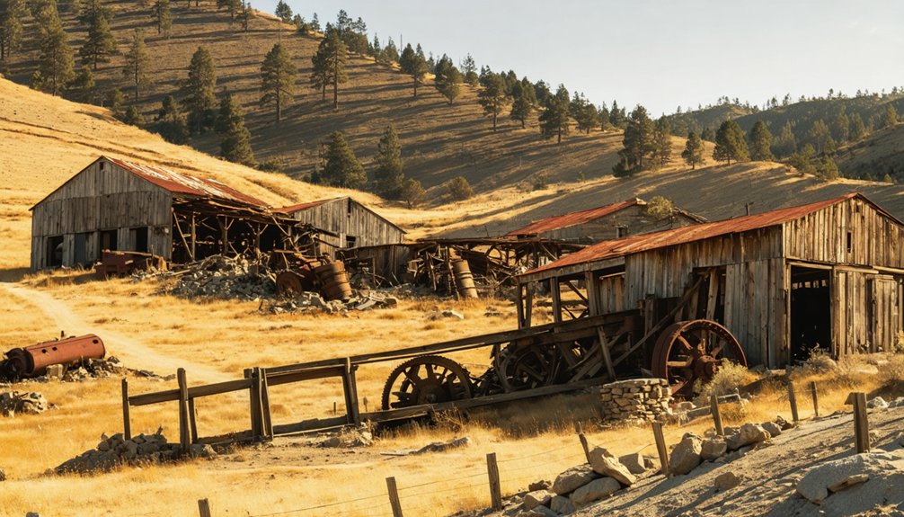
Quartzburg: Tracing the Hard-Rock Mining Legacy
Among the scattered mining camps that dotted Mariposa County’s gold-bearing hills, Quartzburg emerged as something more substantial—a town where hard-rock mining wasn’t just an occupation but a shared endeavor that shaped California’s mining regulations.
Where scattered mining camps saw temporary fortune, Quartzburg built something lasting—a community that forged California’s mining future through shared purpose.
When you explore Quartzburg’s historical significance, you’ll discover a settlement that moved beyond placer operations to pioneering quartz mining techniques.
In 1851, miners gathered here to establish claim regulations that became statewide standards.
The town’s legacy includes:
- The Big Blue mine’s extraction of $1.8 million in gold
- An 80-stamp mill processing ore for 200 workers
- Colonel Thomas Thorn’s establishment of civic infrastructure
- The 1853 mustering of California Rangers pursuing Joaquin Murrieta
- Community institutions including a school, Masonic Lodge, and post office
Today, only cemetery stones and olive tree fragments mark where this regulatory pioneer once stood.
Planning Your Ghost Town Adventure Near Mariposa
While Quartzburg’s stamp mills have fallen silent and its regulatory innovations have passed into historical record, the ghost towns scattered across Mariposa County remain accessible for those who’d trace the county’s mining heritage firsthand.
Explorers seeking a different experience may also venture to ghost towns near Monterey California, where remnants of the past whisper stories of former lives and bustling communities. Here, the abandoned structures and crumbling roads invite curiosity, making it a perfect setting for photography and reflection on the region’s rich history. As you wander through these desolate landscapes, the beauty of nature reclaiming its space adds an eerie but captivating charm.
You’ll find Bear Valley, Hornitos, and Mount Ophir clustered along Highway 49, allowing a half- or full-day loop. Bear Valley Road winds ten miles through rocky cuts to Hornitos’ crumbling plaza and hilltop cemetery.
Before you go, check access conditions with local historical societies—many sites sit on private ranch land where trespassing laws apply.
Ghost town exploration demands respect for both historical preservation and structural hazards: unstable brick walls, mine adits, and collapsed tunnels pose real risks.
Carry offline maps, emergency contacts, and ample water; cell coverage fades quickly beyond Mariposa’s town limits.
What to Bring When Exploring Abandoned Mining Settlements
Because Mariposa County’s ghost towns occupy terrain where a twisted ankle or rockfall can strand you miles from help, your pack list must balance lightweight mobility with serious contingency planning.
Veteran explorers treat their gear checklist as non-negotiable insurance against avoidable disasters.
Every piece of equipment serves as your lifeline when stone corridors and abandoned shafts separate you from civilization.
Essential safety precautions start with:
- Above-ankle hiking boots with thick soles for nails and uneven ground
- N95 or P100 respirator for mold, silica dust, and rodent droppings in old mill buildings
- Climbing helmet to protect against rockfall in adits and collapsing headframes
- High-output headlamp plus spare batteries for hands-free navigation through dark shafts
- Comprehensive first aid kit and emergency blanket for treating injuries miles from pavement
Layer heavy fabric clothing, carry offline GPS maps, pack extra water, and always tell someone your route before descending into Mariposa’s forgotten camps.
Frequently Asked Questions
Are Ghost Town Sites Near Mariposa Safe to Visit With Children?
Semi-ghost towns like Hornitos and Bear Valley offer child-friendly activities with visible ruins and plaques, but you’ll need safety precautions: avoid unstable structures, mine shafts, and unmarked private property while exploring these historic Gold Rush communities together.
Do I Need Permits to Explore Ghost Town Ruins in Mariposa County?
You’ll need landowner consent for private sites and special-use permits for commercial activities on public lands. Most casual visits follow standard exploration guidelines, but artifact collection remains prohibited under permit requirements protecting California’s Gold Rush heritage.
Which Ghost Towns Near Mariposa Have Restrooms or Visitor Facilities?
Hornitos and Coulterville offer you restroom availability and visitor amenities—public facilities, museums, and cafés anchor these semi-ghost towns, while true ruins like Bagby lack services entirely, demanding self-sufficient exploration.
Can I Metal Detect or Collect Artifacts at Abandoned Mining Sites?
You’ll face serious consequences—metal detecting regulations and artifact preservation concerns mean federal and state laws absolutely prohibit removing historic items from most abandoned sites. Respect our shared heritage; explore with cameras, not shovels, preserving freedom for future generations.
What Are the Best Months to Visit Ghost Towns Near Mariposa?
The best seasons are April through June and September through October, when you’ll enjoy comfortable temperatures and clear trails. Weather considerations include avoiding midsummer’s scorching heat and winter’s unpredictable snow closures at higher elevations.
References
- https://enjoyorangecounty.com/california-ghost-towns/
- https://en.wikipedia.org/wiki/List_of_ghost_towns_in_California
- http://freepages.rootsweb.com/~gtusa/history/usa/ca/mrp-co/c.htm
- https://freepages.history.rootsweb.com/~gtusa/usa/ca/mrp-co/w.htm
- https://www.yosemite.com/yosemite-mariposa-county-region/southern-mariposa-county/hornitos-ca/
- https://californiahighsierra.com/trips/explore-ghost-towns-of-the-high-sierra/
- https://www.ghosttowns.com/states/ca/camariposa.html
- https://atomicredhead.com/2016/09/16/ghost-towns-along-highway-49/
- https://www.savetheredwoods.org/blog/spooky-redwoods-ghost-town-remains-a-presence/
- https://noehill.com/mariposa/cal0333.asp


