You’ll find four authentic ghost towns within driving distance of Mesquite, each telling a different story of Nevada’s boom-and-bust mining era. St. Thomas emerges from Lake Mead when water levels drop, revealing foundations from its 1865 establishment. Rhyolite showcases skeletal bank buildings and the famous Bottle House near Death Valley. Gold Butte requires serious 4WD capability but rewards you with 1905-era mining remnants and Spanish arrastras. Tem Piute’s tungsten operations left decaying structures that still hold documents from their final years—though accessing these sites demands proper preparation and historical context.
Key Takeaways
- St. Thomas, submerged by Lake Mead in 1938, re-emerged in 2002 and features visible ruins from Mormon settlement era.
- Rhyolite showcases preserved structures including the iconic Bottle House and Cook Bank Building from its 1900s gold rush boom.
- Goldwell Open Air Museum at Rhyolite offers seven monumental sculptures viewable 24/7 with free admission on eight desert acres.
- Gold Butte requires high-clearance 4WD vehicles and contains scattered 1905 mining remnants, arrastras, and historic prospector cabins.
- Tem Piute, a silver mining camp from 1865, peaked at 50 residents before tungsten operations briefly revived interest in 1916.
St. Thomas: the Sunken Settlement Emerging From Lake Mead
When Mormon pioneers under Thomas Smith established St. Thomas in 1865 along the Muddy River, they built a thriving agricultural community of 500 souls.
You’d have found cotton fields, trading posts, and bustling streets where the settlement served as Pah-Ute County’s seat.
But boundary surveys placed them in Nevada, triggering brutal back-tax demands payable in gold. The Mormons abandoned their town in 1871, torching homes behind them.
Non-Mormon settlers revived St. Thomas until Hoover Dam’s construction sealed its fate. The federal government purchased properties, and by 1938, Lake Mead’s waters claimed this sunken history entirely.
For sixty years, 60 feet of water concealed the submerged ruins—streets, foundations, and orchards vanished beneath the reservoir, waiting for drought to reveal their secrets once more. The town re-emerged in 2002 as water levels dropped, exposing the foundations and remnants that had been hidden for decades. Today, visitors can explore well-defined trails that descend approximately 0.6 miles from the trailhead to the exposed town ruins.
Rhyolite: Death Valley’s Premier Gold Rush Relic
When you walk Rhyolite’s dusty streets today, you’ll encounter the skeletal remains of grand ambitions frozen in concrete and stone—most importantly the three-story Cook Bank Building, which cost $90,000 in 1908 and now stands as one of the American West’s most photographed ruins.
The 1906 Bottle House, built by miner Tom Kelly from roughly 50,000 glass bottles and mud, offers a quirky counterpoint to the town’s more imposing civic architecture.
Just outside the historic townsite, the Goldwell Open Air Museum adds a surreal modern layer to the landscape, where contemporary outdoor sculptures dialogue with century-old decay. Among the museum’s installations is Albert Szukalski’s “The Last Supper,” which enhances the site’s cultural significance. The Bureau of Land Management now manages the Rhyolite Historic Area, protecting these ruins and interpreting the town’s legacy for visitors and historians alike.
Historic Buildings and Structures
Standing as silent monuments to boom-and-bust ambition, Rhyolite’s surviving structures represent some of the most photographed ghost town ruins in the American West.
You’ll find the three-story Cook Bank Building‘s skeletal facade, a $90,000 symbol of financial optimism that completed just before the 1910 collapse. The mission-style train depot, costing $130,000 in 1907, once processed fifty freight cars daily before becoming a speakeasy casino in 1935.
Tom Kelly’s Bottle House showcases the architectural significance of frontier ingenuity—50,000 beer bottles mortared together when lumber proved too expensive. The elaborate schoolhouse, built in 1909 for $220,000, closed just two years later, with its debt not fully paid until 1970.
These cultural remnants, from cast-adobe miners’ cabins to jail ruins, reveal the stark contrast between Rhyolite’s grand civic vision and working-class reality. The town once supported a miner’s union hospital, along with hotels, stores, and an ice plant that served the booming community.
Today’s Bureau of Land Management preserves what economic forces couldn’t destroy.
Goldwell Open Air Museum
Against the austere backdrop of Rhyolite’s crumbling ruins, seven monumental sculptures rise from the desert floor like fever dreams materialized in steel, plaster, and cinder block.
Belgian artist Albert Szukalski initiated this sculpture park in 1984, seeking what he called an “art situation” in the unregulated Western landscape. You’ll find his ghostly “Last Supper”—life-size figures frozen in plaster-soaked burlap—alongside a 24-foot steel prospector honoring Shorty Harris, whose 1904 discovery triggered Rhyolite’s boom. Szukalski first created an earlier iteration of “The Last Supper” in Belgium in 1974 before bringing his vision to the Nevada desert.
The desert art here operates on permanence and decay simultaneously: a chrome tangle of car parts, a pink cinder-block woman, a winged figure reaching skyward. This dramatic ghost town once housed over 10,000 residents during its mining heyday, with a train depot and other structures still standing as reminders of early 20th-century boom-and-bust cycles.
The Goldwell Open Air Museum welcomes you 24/7 without admission fees—eight acres where convention surrenders to creation.
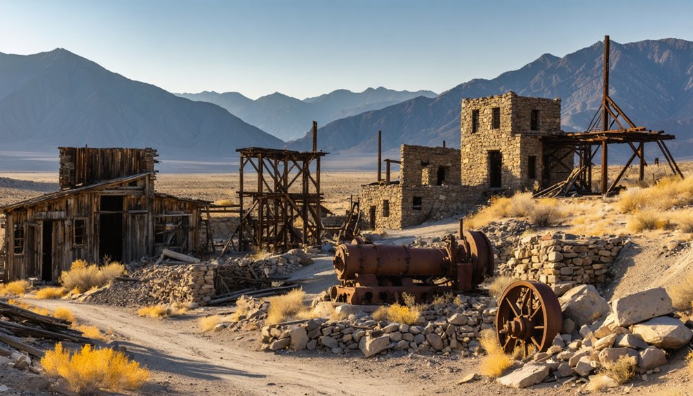
Gold Butte: Remote Desert Mining Outpost
You’ll find Gold Butte’s story more compressed than Rhyolite’s—discovered in 1905, the camp swelled to 2,000 residents within months, then collapsed by 1910 when the ore pinched out.
Reaching this ghost town demands serious preparation: it sits deep within the 300,000-acre Gold Butte National Monument, accessible only by high-clearance 4WD over rough desert trails that can strand the unprepared.
What remains today are scattered foundations, a historic cabin site where prospectors Bill Garrett and Art Coleman lived for four decades after the boom, and their graves marking one of Nevada’s loneliest outposts. The surrounding landscape hosts Desert Bighorn Sheep and Mojave Desert Tortoises among red sandstone formations and twisting canyons. Nearby, you can explore Gibbs Camp, located half a mile east, which features a granite arrastra—a primitive mill carved from a single stone that miners used to grind ore in the early 1900s.
Mining Boom and Bust
Long before the twentieth-century prospectors arrived with their dreams of easy riches, Spanish miners had already worked the Gold Butte area, leaving behind at least four stone arrastras—circular crushing mills that still dot the desert floor near the old townsite.
When gold was discovered around 1905, the camp exploded to 2,000 residents almost overnight. Tents outnumbered permanent buildings, and mining techniques ranged from primitive arrastras to optimistic speculation.
The boom collapsed by 1909:
- Post office closed in 1911, marking the town’s official death
- Bill Garrett and Art Coleman mined for 40 years after everyone left, becoming ghost town legends
- They’re buried at Gold Butte, their wooden cabin long since weathered away
- Most settlers abandoned everything, leaving scattered ruins across the monument
Accessing the Remote Site
Reaching Gold Butte requires commitment and preparation that most casual ghost town hunters aren’t prepared to make.
You’ll drive 35–40 miles from Mesquite via Gold Butte Road, watching pavement surrender to graded dirt before conditions deteriorate into washboard and embedded rock. Travel times stretch beyond two hours one-way as you navigate wash crossings and faint mining spurs marked only by weathered BLM route numbers.
Understanding vehicle requirements isn’t optional here—high-clearance is mandatory beyond Whitney Pocket, with 4WD strongly recommended for accessing the historic townsite and mines.
I’ve watched unprepared rigs turn back at the first deep rut. Cell coverage disappears entirely, towing services don’t exist, and abandoned mine shafts wait to swallow the careless.
These access routes demand self-sufficiency and proper equipment, rewarding only those willing to venture beyond civilization’s edge.
Exploring Gold Butte Today
The physical effort of reaching Gold Butte pales against what you’ll discover scattered across this windswept plateau where 2,000 fortune-seekers once crowded into canvas shelters.
You’ll encounter genuine remnants from 1905’s gold rush, including the weathered cabin built by prospectors Bill Garrett and Art Coleman, who rest in nearby historic graves.
Evidence of early mining techniques appears throughout the townsite:
- An 8-foot granite arrastra demonstrates how ore was crushed without modern machinery
- Accessible mine shafts reveal where fortune-hunters extracted precious metals
- Spanish excavations from 1730 predate American operations by nearly two centuries
- The Devil’s Throat sinkhole stretches 110 feet across as evidence to geological wonders
Ancient petroglyph panels showcase Nevada’s first inhabitants, while foundations mark where dreams flourished briefly before 1910’s inevitable abandonment.
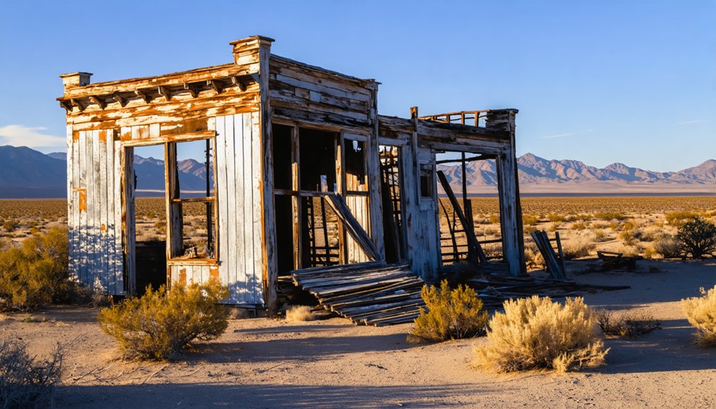
Tem Piute: Where Silver and Tungsten Shaped History
High on Tempiute Mountain‘s southern slope, silver-hungry prospectors struck ore in 1865, establishing a mining camp that would experience two distinct lives separated by half a century.
Tempiute History reveals a settlement plagued by water scarcity—every drop hauled from the valley below. The camp peaked at 50 souls during the late 1870s before the post office shuttered in 1883, leaving stone foundations and abandoned shafts.
You’ll find the Mining Legacy resurrected in 1916 when tungsten deposits sparked renewed interest.
Union Carbide ran the Lincoln Mine intermittently until the mid-1980s, when cheap Chinese imports ended operations.
Today, you can explore these ruins six miles southeast of Rachel, where documents from the final mining years still scatter among decaying structures on unrestricted public land.
Planning Your Ghost Town Adventure From Mesquite
From Tempiute’s tungsten-laden slopes to Gold Butte’s abandoned foundations, successful exploration demands preparation that’ll save you from spending a night stranded beside Joshua trees.
Your vehicle needs four-wheel drive with serious ground clearance—Gold Butte’s rugged track’ll punish anything less. Cell service vanishes beyond Whitney Pockets, so paper maps aren’t optional. I’ve watched unprepared adventurers turn back at the first washout.
Essential preparations for your ghost town expedition:
- Download offline maps and carry physical navigation tools
- Pack emergency water, food, and first-aid supplies for remote desert conditions
- Research mining techniques and ghost town history before visiting to recognize significant features
- Check weather forecasts and avoid summer heat exceeding 110°F
The monument’s 3,000 acres hold genuine freedom—no crowds, no rangers directing your steps.
Just you, authentic mining relics, and landscapes unchanged since 1910.
What to Bring for Desert Exploration

Nobody survives Gold Butte’s backcountry on optimism alone—I’ve towed out three “light packers” who figured a single water bottle would suffice.
Your desert essentials start with four liters of water per person daily, plus a five-gallon vehicle reserve. Pack electrolyte tablets, energy bars, and salty snacks to counter dehydration.
Water isn’t optional in Gold Butte—four liters per person daily keeps you functional, not comfortable.
Sun protection means SPF 30+ sunscreen, wide-brimmed hat, and UV-blocking sunglasses. Layer lightweight, quick-dry clothing over cotton jeans—night temperatures plummet forty degrees.
Your exploration gear includes sturdy boots for rocky mine approaches, headlamp with spare batteries, paper maps for dead-zone navigation, and a basic first-aid kit.
Don’t skip the shovel, spare tire, and emergency shelter. These ghost towns reward preparation, not wishful thinking.
Preserving Nevada’s Mining Heritage
When you stand inside a headframe at Tonopah Historic Mining Park, touching rusted cables that once hauled silver ore from a thousand feet down, you’re experiencing preservation that works.
Nevada’s mining preservation isn’t about roping off ruins—it’s about keeping history alive while you explore freely. Preserve Nevada and UNLV identify endangered sites before they vanish, while organizations like the Tonopah Historic Mining Park Foundation maintain actual workings you can walk through.
Why mining preservation matters for your ghost town adventures:
- Mining museums archive original tools, photographs, and documents from abandoned camps
- Cultural heritage surveys determine which structures stay standing versus demolished for safety
- Over $4.5 billion in reclamation bonds fund long-term stabilization of historic sites
- Advocacy campaigns generate volunteer opportunities to physically restore structures
Frequently Asked Questions
Are There Guided Tours Available for Ghost Towns Near Mesquite?
Yes, you’ll find guided adventures through local outfitters like Mesquite Outfitters offering 4×4 tours to Gold Butte ghost towns. These trips provide historical insights, navigation expertise, and safe access to remote mining camps you shouldn’t tackle alone.
Which Ghost Towns Are Safe to Explore With Children?
You’ll find a million safer options than deep-mine sites—stick to Gold Butte’s ground-level foundations for family-friendly exploration. Its historical significance shines through scattered artifacts and machinery, offering kids hands-on discovery without dangerous vertical hazards.
Can You Camp Overnight Near These Ghost Town Sites?
Yes, you can camp overnight near Gold Butte ghost towns on BLM land, following dispersed camping regulations. Expect zero ghost town amenities—pack all water, food, and gear. I’ve found pre-disturbed sites work best while respecting cultural resources.
What Is the Best Time of Year to Visit Nevada Ghost Towns?
You’ll absolutely *love* fall and spring—they’re the best seasons for Nevada ghost towns. Weather conditions stay mild (60s–70s °F), roads remain passable, and you’ll avoid scorching summers or snow-blocked winters while exploring freely.
Ghost towns in Nevada’s film history serve as remarkable backdrops for many classic Westerns, bringing an eerie charm to the cinematic landscape. As you wander through these abandoned places, it’s fascinating to think about the stories they tell, both on and off the screen. Each site has its own unique character, contributing to a rich tapestry of Americana that continues to captivate filmmakers and explorers alike.
Do You Need Permits to Explore Ghost Towns in Nevada?
You don’t need permits for casual ghost town visits on public land, but exploration regulations kick in if you’re disturbing soil or collecting artifacts—historical preservation laws protect these sites from unauthorized excavation and removal.
References
- https://coyotecountrylv.com/2023/05/03/nevada-this-is-the-best-ghost-town-in-the-state/
- https://dixie4wheeldrive.com/off-road-trail-spotlight-gold-butte-ghost-town-and-radio-crystal-mine-mesquite-nevada-trails/
- https://lasvegasareatrails.com/rhyolite-ghost-town-death-valley-nevada/
- https://nvtami.com/2024/03/03/mesquite-presidents-weekend-trip-to-mesquite/
- https://nvtami.com/2025/02/15/mesquite-meanderings/
- https://travelnevada.com/ghost-town/
- https://www.nps.gov/lake/learn/nature/st-thomas-nevada.htm
- https://www.roadtripryan.com/go/t/nevada/southern-nevada/st–thomas-ghost-town
- https://travelnevada.com/nevada-magazine/st-thomas/
- https://www.youtube.com/watch?v=JnIIQymTY3w


