You’ll find exceptional ghost towns within 90 minutes of Montrose, including Animas Forks—Colorado’s most intact high-alpine mining camp at 11,200 feet—and the Red Mountain Town corridor along the Million Dollar Highway, where 10,000 residents once worked mines that produced millions before the 1893 Silver Panic. Carson City, Ironton, and Guston offer well-preserved log structures and mining remnants accessible via 4WD routes from June through early October. The Museum of the Mountain West in Montrose provides essential historical context before you explore these remnants of the San Juan Mining Belt’s 1870s–1890s boom-and-bust cycle.
Key Takeaways
- Animas Forks, Colorado’s most intact high-alpine mining camp at 11,200 feet, features preserved cabins and the historic Gold Prince Mill.
- Red Mountain Town once housed 10,000 residents and 100 businesses before fires and the 1893 Silver Panic destroyed most structures.
- Carson City peaked around 1900 with 400–500 residents and still contains well-preserved log structures accessible via rugged roads.
- High-clearance 4WD vehicles are necessary for most ghost towns, with best access from June to early October at elevations exceeding 12,000 feet.
- The Museum of the Mountain West in Montrose showcases 28 relocated structures and 500,000 artifacts documenting regional ghost town history.
The San Juan Mining Belt: Historic Foundation of Regional Ghost Towns
When the Brunot Agreement ceded approximately 4 million acres of Ute land in 1873, it transformed the San Juan Mountains from restricted indigenous territory into the core of Colorado’s richest mining belt—a shift that directly seeded the ghost towns you’ll encounter near Montrose today.
The 1874 rush released prospectors across Arrastra Gulch, Henson Creek, and the Uncompahgre Valley, where early gold and silver strikes sparked seasonal camps that evolved into permanent settlements.
Seasonal prospector camps in Arrastra Gulch and Henson Creek transformed into permanent mining settlements following the 1874 gold and silver rush.
By 1877–1879, Silverton, Lake City, and Ouray districts were producing large ore quantities, anchoring an integrated frontier of mills, smelters, and road networks.
This mining history created roughly 196 patented claims and 425 unpatented workings—dense staking that fueled localized booms and the ghost town legends you’re free to explore across the northern San Juans.
Lake City’s incorporation in 1875 followed the Hotchkiss mine discovery, which drove the town’s rapid expansion to 2,000 inhabitants and established it as a mining hub alongside emerging settlements at Sherman, Whitecross, and Burrows Park.
The Animas District’s 1880s boom, triggered by gold discoveries in Arrastra Gulch, transformed the valley northeast of Silverton into a major producer until the railroad’s 1882 arrival accelerated ore shipments and settlement growth.
Animas Forks: Colorado’s Premier Preserved Mining Camp
Perched at 11,200 feet where three forks of the Animas River converge, Animas Forks stands as Colorado’s most intact high-alpine mining camp—a distinction earned through elevation, preservation, and its role as the northern anchor of the San Juan mining frontier.
You’ll find mining heritage embodied in structures dating to 1873, when the first cabin rose near newly discovered lode deposits. By 1876, thirty cabins clustered around a hotel, saloon, and post office, housing 450 souls at peak season.
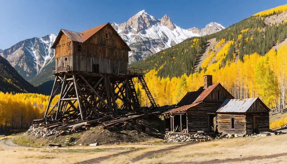
The massive Gold Prince Mill, constructed in 1904–1905 for $500,000, processed 500 tons daily through 100 stamps—advanced technology powered by electricity and connected by telephone.
Otto Mears built a wagon road in 1875, transforming access to the remote mining district and accelerating development throughout the area.
A severe blizzard in 1884 buried the town under 25 feet of snow, isolating residents for 23 days and testing the limits of high-altitude survival.
Today, ghostly echoes resonate through weathered frames along the Alpine Loop Backcountry Byway, where you’re free to explore Colorado’s mining past firsthand.
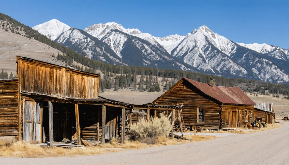
Red Mountain Town and the Million Dollar Highway Ghost Sites
Though silver and gold discoveries on Red Mountain Pass sparked multiple camps in the late 1870s and early 1880s, consolidation transformed scattered settlements—including Sky City near the future National Belle Mine and rival platted Rogersville—into a single incorporated entity when Red Mountain Town received its post office in January 1883.
At 11,300 feet elevation, this second-ranked Colorado silver district after Leadville boasted over 100 businesses, schools, churches, newspapers, and up to 10,000 residents at its peak. The National Belle’s famous “Treasure Cave” yielded $9 million in ore before the 1893 Silver Panic triggered collapse. The Silverton Railroad reached Red Mountain Town in September 1888, connecting the remote mining camp to wider markets.
Fires in 1892, the mid-1890s, and 1939 erased most structures. Among the district’s most productive operations were the Yankee Girl, Guston, and National Belle mines, which drove Red Mountain’s reputation as a major silver producer. Today you’ll find ghostly remnants: the iconic National Belle headframe, scattered foundations, a leaning cabin, and a historic jail along Red Mountain’s roadside.
Ironton and Guston: Corridor Communities of the Ouray–Silverton Route
As Red Mountain Town anchored the high-elevation silver district, Ironton and Guston served as essential corridor communities**** strung along the transportation spine linking Ouray with Silverton.
You’ll find Ironton’s legacy rooted in its role as a staging point—founded as Copper Glen in 1883, it swelled to roughly 1,000 residents who built 300 structures in three weeks, supporting 12 saloons, hotels, and chain stores.
Its flat terrain at 9,800 feet enabled efficient freight handling and rail operations that sustained two daily Denver & Rio Grande trains.
Otto Mears completed a toll road in 1884 that established Ironton as a critical transportation hub for the district.
Today, an interpretive sign marks the site where this once-thriving settlement stood.
Guston, settled alongside the Guston-Robinson and Yankee Girl silver mines, housed 300 residents by 1890, complete with a post office and the *Guston Paralyzer* newspaper.
The mid-1890s silver collapse triggered swift Guston decline—abandoned by 1900, its buildings crumbled by 1950.
Carson City: High-Alpine Ghost Town on the Continental Divide
Straddling the Continental Divide at elevations between 11,600 and 12,000 feet, Carson became one of Colorado’s most extreme high-alpine mining ventures****, where fortune-seekers endured climatic conditions that would ultimately doom permanent settlement.
Founded around 1882–1889, the camp’s mining heritage peaked near 1900 when 400–500 residents worked roughly 150 claims. The St. Jacob Mine alone produced $190,000 in 1898, running three shifts continuously.
Yet climate challenges proved insurmountable—miners resorted to toboggans for winter ore transport, and brutal storms discouraged year-round operations. Economic volatility compounded nature’s assault; the Panic of 1893 stalled development until brief gold discoveries in 1896.
Today you’ll find well-preserved log structures protected by metal roofs, accessible via Wager Gulch’s rugged 4×4 road, though private property restrictions limit close exploration. The 5.63-kilometer approach features gravel and embedded rocks that demand high-clearance vehicles and experienced mountain driving skills. Jeep rentals are available in nearby Lake City, Ouray, and Silverton, all within day trip distance for exploring Carson and surrounding ghost towns.
Accessing Ghost Towns via the Alpine Loop Backcountry Route
While Carson’s remote location above 11,600 feet demonstrates the extreme conditions early miners accepted to pursue ore, reaching most San Juan ghost towns today requires travelers to master the Alpine Loop Backcountry Byway—a 63-mile unpaved corridor that connects Ouray, Lake City, and Silverton through terrain originally carved for mule-drawn ore wagons.
You’ll need a high-clearance 4WD vehicle to navigate rocky surfaces, steep grades, and shelf roads between June and early October. The route climbs from 7,792 feet in Ouray to 12,800 feet at Engineer Pass, passing seven ghost towns where mining history remains tangible through standing cabins, mill ruins, and tram remnants.
Ghost town exploration here demands full preparation—extra fuel, supplies, and weather awareness—yet rewards you with unmediated access to Colorado’s silver-era past.
the remnants of abandoned sites near Salida Colorado tell tales of the miners who once sought fortune in these rugged mountains. As you explore, be prepared to encounter crumbling structures and remnants of machinery that highlight a time when this area buzzed with life and ambition. Each site holds a story waiting to be uncovered, making the journey both a historical adventure and a captivating look into the past.
Museum of the Mountain West: Montrose’s Gateway to Ghost Town History
Before you drive the Alpine Loop’s high passes to scattered ruins, you’ll gain essential context at Montrose’s Museum of the Mountain West, where historical archaeologist Richard E. Fike assembled 28 relocated structures into “Adobe Flats”—a recreated frontier townscape mirroring ghost towns you’ll explore.
Founded in 1997 on six acres, this 501(c)(3) nonprofit preserves over 500,000 artifacts within an authentic street layout featuring boardwalks, an 1882 railroad section house, and the Stott Hotel & Saloon.
Exhibits reconstruct essential businesses—post office, general store, saloon, sheriff’s office—displaying medical tools, household goods, and mining-era materials from defunct Colorado and Utah settlements.
Fike’s artifact preservation work documents the material culture vanishing from remote sites, making this accessible gateway your interpretive foundation before venturing into the backcountry’s remaining camps.
Planning Your Ghost Town Adventure From Montrose
Winter conditions at these elevations severely restrict access, making summer your ideal exploration window.
You’ll find the best ghost town photography opportunities at Animas Forks’ Duncan House and St. Elmo’s preserved storefronts.
Pack navigation tools, emergency supplies, and respect historical preservation protocols—don’t disturb artifacts or structures.
Red Mountain Town’s proximity to Highway 550 offers easier access than remote Carson, helping you prioritize destinations based on vehicle capability and experience level.
What to Expect: Structures, Ruins, and Seasonal Considerations
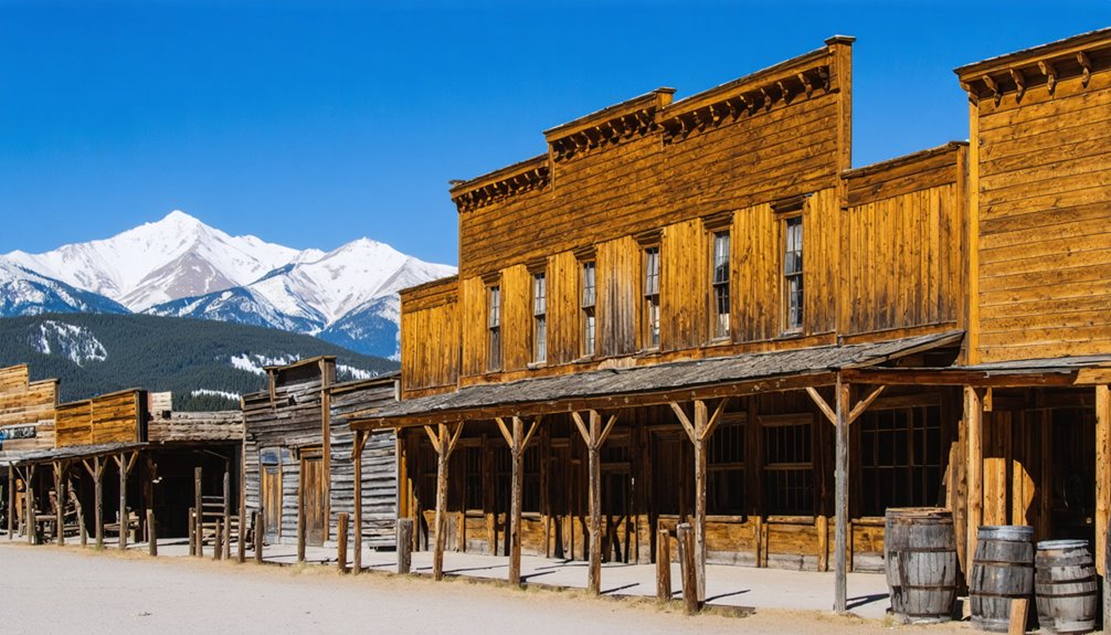
You’ll encounter varying levels of preservation across Montrose-area ghost towns, from Saint Elmo’s 43 standing buildings including its operational General Store to scattered cabin foundations and weathered mine structures at sites like Teller City and Red Mountain Town.
Most high-elevation locations close entirely during winter months due to impassable roads and extreme conditions—the same harsh weather that forced abandonment of settlements like Independence and Governor Basin above 12,000 feet.
Summer and fall visits require high-clearance or 4×4 vehicles for alpine sites, while lower-elevation towns remain accessible with standard vehicles during operating seasons.
Cabin Foundations and Mine Structures
Scattered across the steep basins above Montrose, cabin foundations and mine structures tell a visible story of boom-and-bust settlement patterns that defined San Juan mining districts between the 1870s and early 1900s.
You’ll encounter dry-stack stone footings, rotted sill logs, and scattered square nails marking former habitation sites at elevations where log walls couldn’t withstand a century of snowpack and decay. Weathered boarding houses still cling to slopes near operations like the Mountain Top Mine, while collapsed outbuildings survive only as low stubs in avalanche terrain.
Mining artifacts—stove fragments, rusted cans, glass shards, ore-processing hardware—cluster around these cabin remnants, creating rich surface scatters that map vanished settlements.
Headframes, ore bins, and tram towers loom as skeletal frameworks above valley floors, their timbers and steel cables deteriorating under relentless alpine exposure.
Winter Closures and 4×4 Access
Reaching these cabin foundations and mine structures demands careful planning around elevation and season, especially when roads climb above 11,000 feet into the San Juan high country.
Animas Forks, Carson, and Governor Basin sit locked under snowpack from late fall through late spring, transforming Alpine Loop routes into over-snow terrain accessible only by snowmobile, skis, or snowshoes.
Even dedicated 4×4 rigs face accessibility challenges during shoulder seasons when mud, ice, and avalanche debris compound technical obstacles on unmaintained tracks.
Winter travel to these sites isn’t routine tourism—it requires off-road builds, recovery gear, and extensive backcountry experience.
Snowdrifts obscure open shafts and unstable floors, while freeze-thaw cycles accelerate structural collapse.
You’ll find rental concessions shuttered until summer, reflecting that these ghost towns demand respect for both mechanical limits and mountain conditions.
Frequently Asked Questions
Are Ghost Town Sites Near Montrose Safe for Children and Families?
Most ghost town sites near Montrose aren’t ideal for child safety due to unstable structures, open mine shafts, and remote locations. You’ll find safer family activities at supervised heritage sites like Montrose’s Museum of the Mountain West instead.
Can I Camp Overnight at Ghost Town Locations in the Area?
You’ll find dispersed camping allowed on surrounding BLM and National Forest land near most ghost towns, but overnight restrictions and camping regulations prohibit sleeping inside historic structures—verify current rules with local ranger districts before heading out.
What Permits or Fees Are Required to Visit These Ghost Towns?
Most ghost towns near Montrose don’t require permits or fees since they’re on public land. However, specific permit requirements and fee structures vary by location and land management agency, so you’ll need to verify directly with local authorities beforehand.
Are Guided Ghost Town Tours Available From Montrose?
You’ll find guided tours at Montrose’s Museum of the Mountain West, where relocated frontier buildings reveal ghost town history. For backcountry exploration, you’ll need to drive to Ouray-based jeep operators offering Alpine Loop excursions.
What Wildlife Hazards Should Visitors Expect at High-Elevation Ghost Towns?
You’ll face wildlife encounters including black bears, mountain lions, and aggressive moose, plus rodent-borne hantavirus in old buildings. Altitude sickness above 9,000 feet compounds these risks by impairing your judgment and coordination near hazards.
References
- https://en.wikipedia.org/wiki/List_of_ghost_towns_in_Colorado
- https://www.colorado.com/articles/colorado-ghost-towns
- https://coloradoinfo.com/blog_post/explore-ghost-towns-in-colorado/
- https://coloradorealty-experts.com/three-of-colorados-most-popular-ghost-towns/
- https://www.uncovercolorado.com/ghost-towns/
- https://www.visitouray.com/ghost-towns
- https://www.youtube.com/watch?v=xJLofgWapYE
- https://1037theriver.com/10-ghost-towns-to-visit-when-touring-around-colorado/
- https://www.legendsofamerica.com/early-southwestern-colorado-mining/
- https://westernmininghistory.com/library/38267/page1/


