You’ll find several preserved coal towns within New River Gorge National Park, including Kaymoor, which produced 16 million tons of coal with 101 beehive ovens; Nuttallburg, a National Historic Site featuring 80 coke ovens and nearly 100 dwellings from the 1870s; Thurmond, an isolated railroad division point generating $4.8 million in 1910 freight revenue; and Winona, a “living ghost town” with occupied homes alongside coal-era ruins. These settlements document West Virginia’s smokeless coal industry through their tipples, company houses, and industrial infrastructure, accessible via steep park roads and former railroad grades that reveal the region’s extraordinary industrial heritage.
Key Takeaways
- Kaymoor, Nuttallburg, Thurmond, and Winona are historic coal mining ghost towns located within or near New River Gorge National Park.
- Nuttallburg is a National Historic Site accessible via steep park roads, featuring eighty coke ovens, town ruins, and mining infrastructure.
- Thurmond served as a major railway division point in the 1880s, with preserved storefronts and depot buildings maintained by National Park Service.
- Winona remains a “living ghost town” with occupied homes and an active church alongside abandoned storefronts from the coal era.
- Visitors can explore these sites via trails like Point Trail and Conveyor Trail, requiring high-clearance vehicles and advance preparation.
Kaymoor: Industrial Giant of the New River Coalfield
When the Low Moor Iron Company of Virginia purchased land along the New River in 1873, it held the property in reserve for more than two decades before establishing Kaymoor as a company mine and town in 1899.
Named for company official James Kay and “Low Moor,” the complex shipped its first coal in 1900 to fuel iron furnaces.
Kaymoor’s history reflects remarkable scale—over 16 million tons of coal produced through the early 1960s, a workforce of 1,500 men, and 101 beehive coke ovens.
Industrial innovation arrived early with Harrison compressed-air mining machines, patented in 1877.
After New River & Pocahontas Consolidated Coal Company acquired the operation in 1925, Kaymoor shifted from captive fuel source to broad-market supplier, cementing its role as an industrial giant. The mine’s emphasis on worker protection was evident in safety boards that remained posted throughout the complex, a response to the fatalities that had occurred during operations. The room and pillar system created a network of passageways that enabled systematic coal extraction throughout the mine’s productive decades.
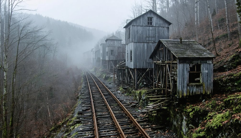
Nuttallburg: Pioneer Settlement of Smokeless Coal
You’ll find Nuttallburg’s origins traced to English-born John Nuttall, who purchased land along Keeneys Creek for roughly $1 per acre in the early 1870s, establishing the gorge’s second operational coal town when the C&O Railway arrived in 1873.
His settlement pioneered commercial shipment of “smokeless” New River coal from seams hundreds of feet above the river corridor, employing extensive conveying systems to transport coal downslope to approximately 80 beehive coke ovens and a riverside tipple.
The National Park Service now provides trail access to this remarkably intact industrial landscape, where you can examine the preserved coke oven bank, conveyor foundations, and colliery structures documenting vertical-integration coal operations from the 1870s through Ford Motor Company’s brief ownership in the 1920s. Production peaked at 240,820 tons in 1925 following Ford’s investments in new mining infrastructure. The site received National Register recognition in 2005, acknowledging its significance as one of the most intact coal-related industrial sites in the United States.
John Nuttall’s 1873 Operation
In 1873, English-born coal operator John Nuttall launched one of the New River Coalfield‘s pioneering industrial operations, transforming remote Keeney Creek hollow into a thriving company town positioned to exploit the region’s famed smokeless coal.
After tracing high-grade bituminous samples to Sewell seam outcrops in 1870, you’ll find he secured 1,500 acres and developed extensive infrastructure before the Chesapeake & Ohio Railway arrived.
By railroad completion, Nuttallburg heritage includes nearly 100 dwellings, 80 coke ovens, and multiple mine openings serving 125 workers. Daily production exceeded 750 tons, making Nuttall the second operator shipping coal from the gorge.
His coal mining technology connected seam to tipple across challenging terrain, establishing industrial-scale extraction that defined New River’s economic transformation and freed workers seeking opportunity. The community’s racially segregated layout positioned white workers on the west side while black workers occupied the east side, a division that characterized the social structure of many Appalachian coal towns. Nuttall continued operating several coal mines in the region until his death in 1897, cementing his role as a foundational figure in Fayette County’s industrial development.
Coke Ovens and Tipple
The eighty beehive-style coke ovens at Nuttallburg transformed raw bituminous coal into high-carbon fuel through controlled baking under regulated airflow, producing the metallurgical-grade coke demanded by pig-iron blast furnaces across industrial America.
You’ll find these ovens positioned strategically throughout the complex alongside the blacksmith shop, carpentry shop, and slate dump—infrastructure that supported continuous coke production operations.
The tipple system coordinated coal processing through three separate conveyor networks, with scales and a headhouse measuring output before shipment.
Workers removed impurities comprising significant coal weight before loading, reducing transportation costs to distant foundries.
This integrated approach to mining technology established Nuttallburg as a self-sufficient operation, where every structure served the singular purpose of extracting maximum value from New River Gorge’s exceptional smokeless seam. The operation projected 500 tons of coal daily, fueling the expanding needs of national industries during the height of the industrial revolution. The Nuttall family established this mining camp around 1872, making it one of the earliest settlements in the New River Gorge.
National Park Service Access
Acquired by the National Park Service in 1998, Nuttallburg now operates as a National Historic District within New River Gorge National Park & Preserve, safeguarding roughly 90 acres of mine complex, town ruins, and industrial infrastructure that represent one of West Virginia’s most intact coal mining operations.
You’ll reach the site via narrow, steep, partly unpaved park roads requiring high-clearance vehicles under certain conditions. NPS management strategies include designated parking areas, signed walking routes, and interpretive panels guiding you through the conveyor system, mine entries, and residential terraces.
Visitor safety precautions emphasize low speeds, sharp curves, and limited sight distances—essential on these remote gorge roads. No services exist on-site; you’ll secure food, fuel, and lodging beforehand in nearby communities. The district remains day-use only. The Park Service has preserved Nuttallburg for over two decades since acquisition, maintaining the site’s historical integrity while making it accessible to visitors.
Fayette and South Fayette: Twin Towns Beneath the Bridge
Unlike Nuttallburg’s hillside perch, Fayette and South Fayette occupied the New River’s banks as twin railroad hubs where C&O operations, coal loading, and commercial activity converged after 1873.
The Fayette Coal and Coke Company’s mine, Martin Blume’s three-story store, and the 1888 Fayette Station Bridge formed the infrastructure core of these communities, which served as the gorge’s primary vehicle crossing for seven decades.
Today you’ll find overgrown foundations and structural remnants along Fayette Station Road at river level, directly beneath the modern span where rail operations once shaped daily life for hundreds of mining families. The scenic 8-mile route winds through the gorge, passing under the New River Gorge Bridge three times before ending near Fayetteville.
Railroad Operations Hub History
When the Chesapeake & Ohio Railway pushed its mainline through the New River Gorge in the 1870s, the narrow river benches on opposite sides of the water became home to Fayette and South Fayette—twin towns born from coal and iron.
You’ll find the industrial evolution began when Martin Blume opened his mine around 1873, securing C&O right-of-way and establishing the area’s first rail stop.
The railroad infrastructure grew rapidly: mainline track, passing sidings, yard trackage, and multiple tipples created a concentrated loading point where coal moved directly from mine openings into freight consists bound for national markets.
The 1889 Fayette Station Bridge unified operations across the river, carrying wagon traffic over both water and rails while workers, supplies, and equipment flowed between the communities serving this critical New River Gorge operational node.
Ruins and Access Today
Today the twin townsites of Fayette and South Fayette survive as fragmented archaeological landscapes within New River Gorge National Park and Preserve, their physical fabric reduced to stone foundations, terraced building pads, and graded slopes that once supported tight-packed rows of miners’ houses, company stores, and coal-handling infrastructure.
You’ll reach these sites via Fayette Station Road, a steep one-way loop descending from the rim, with the modern Tunney Hunsaker Bridge spanning where the 1889 Fayette Station Bridge once linked the communities.
Park pullouts offer short walks to ruins, while “A Tale of Two Towns” wayside markers frame the historical significance of this coal-rail corridor.
Your visitor experience unfolds beneath the soaring 1977 New River Gorge Bridge, contrasting vertical modern engineering with horizontal industrial remnants reclaimed by forest.
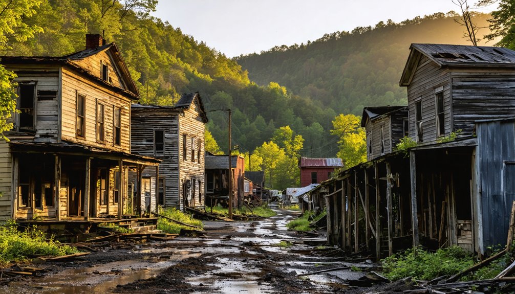
Thurmond: Railroad Division Point Frozen in Time
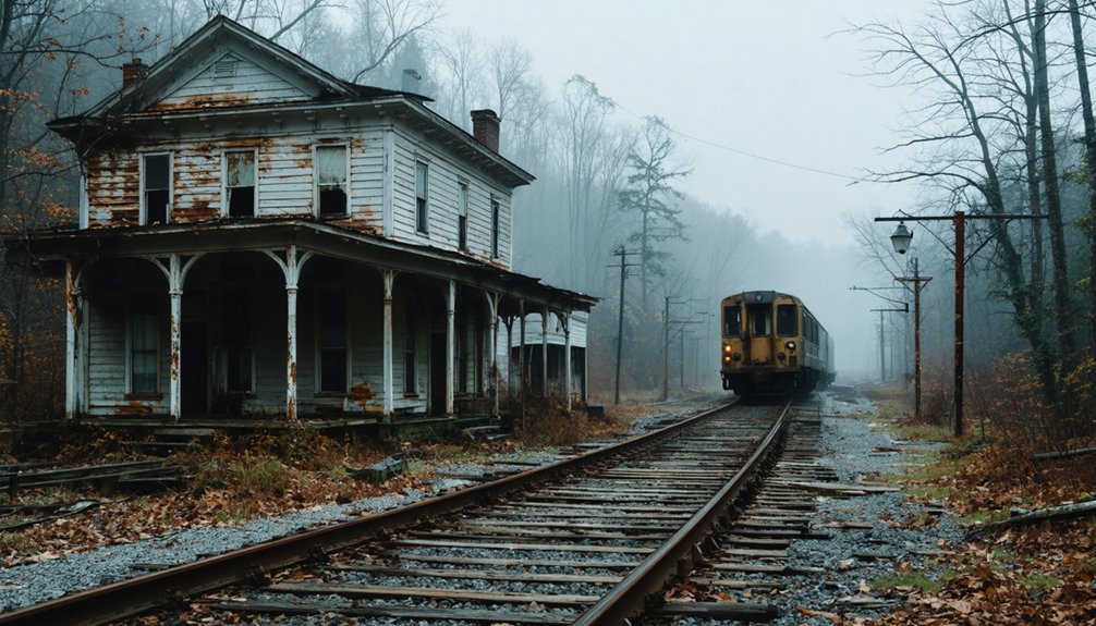
Perched on a narrow bench between the New River and towering gorge walls, Thurmond emerged in the 1880s as a major division point on the Chesapeake & Ohio Railway‘s New River Subdivision—a critical node where coal cars from dozens of surrounding mines were assembled, classified, and dispatched to eastern and midwestern markets.
Thurmond history reveals an extraordinary revenue powerhouse: in 1910, this isolated railyard generated $4.8 million in freight revenue—nearly 20% of C&O’s total—outearning Cincinnati, Richmond, and Charleston combined.
The railroad legacy shaped everything: 15 daily passenger trains, 150 employees working round-the-clock, and a linear town accessible only by rail until 1921.
Today, National Park Service ownership preserves vacant storefronts and depot buildings exactly as dieselization and highway expansion left them—an authentic snapshot of early 20th-century railroad operations.
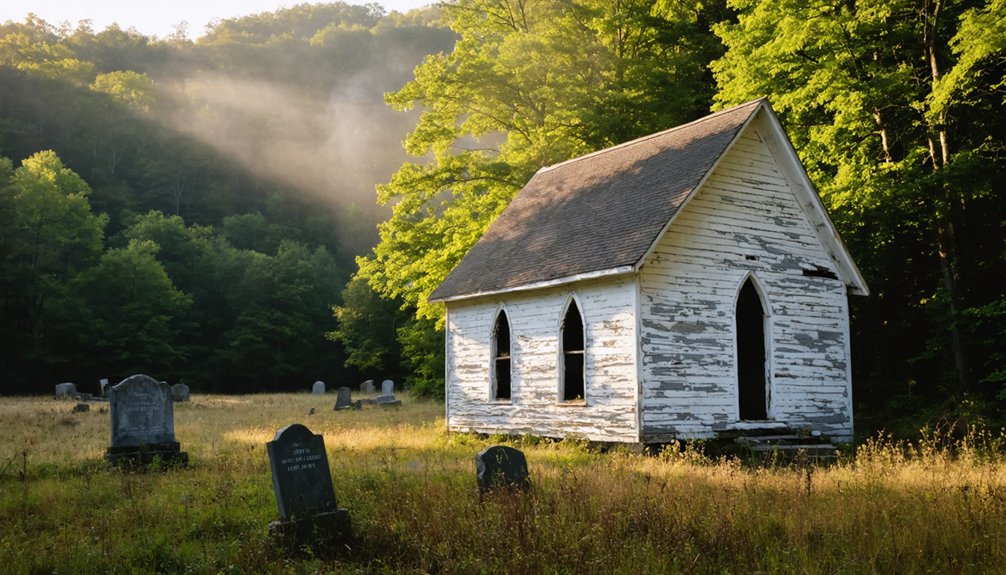
Winona: Living Ghost Town Along Keeney’s Creek
Unlike Thurmond’s dramatic perch at trackside, Winona spreads across the upper Keeney’s Creek drainage four miles upstream from the New River, functioning as what preservationists call a “living ghost town”—a community where occupied homes and an active church coexist with abandoned coal-era storefronts, overgrown foundations, and the skeletal remains of an old pool hall.
You’ll access Winona via Lansing-Edmond Road, following the former Keeney’s Creek Branch railroad grade that once funneled coal down to the C&O main line at Nuttallburg.
Winona’s history includes a school where Carter G. Woodson taught at the turn of the 20th century, before becoming known as the originator of Black History Month.
This community resilience—worship, education, and habitation persisting amid depopulation—offers a quieter ghost-town archetype than Thurmond’s museum-like preservation.
The Rise of the Coal Boom in the 1870s
When the Chesapeake & Ohio Railway drove its main line through the New River Gorge in 1873, it transformed an isolated landscape of steep ridges and untapped coal seams into one of America’s most productive bituminous fields virtually overnight.
You’ll find that three factors drove this explosive industrial expansion:
- Direct market access – Rail connections linked previously inaccessible seams to Midwestern factories and Eastern steel mills, making large-scale coal extraction profitable for the first time.
- “Smokeless” quality – New River’s low-volatile bituminous coal burned cleaner at 15,000 BTU, commanding premium prices from industrial buyers.
- Dirt-cheap land – Outside investors snatched up mineral rights at $1 per acre, triggering rapid development of mines, tipples, and company towns throughout the gorge corridor.
Life in Company-Owned Mining Communities
As coal companies extended their operations deeper into the New River Gorge, they didn’t simply extract minerals—they built entire settlements from scratch, owning virtually every structure where workers and their families lived, shopped, worshiped, and sought medical care.
Coal operators didn’t just mine—they constructed complete worlds where every building, service, and structure belonged to the company.
This absolute company control created captive communities where operators deducted rent directly from wages, paid in scrip redeemable only at company stores, and restricted physical mobility through geographic isolation.
The social structure enforced strict hierarchies: managers occupied larger homes while Black and immigrant laborers inhabited cramped dwellings, often lacking indoor plumbing.
Yet these communities also fostered remarkable diversity—native Appalachians, African Americans, and European immigrants formed multiethnic populations.
Workers spent 10–12 hour shifts underground for roughly $2 daily, accumulating debt while facing constant injury risk.
Decline and Abandonment After World War II
The coal economy that sustained these company-owned communities began its irreversible collapse in the decades following World War II.
You’ll find that multiple forces converged to empty these once-thriving settlements:
- Mining technology advances – By the 1950s, 85 percent of West Virginia coal was cut and loaded with machines, eliminating thousands of traditional jobs that families had relied upon for generations.
- Transportation shifts – Railroads converted from coal-powered steam locomotives to diesel engines, destroying demand for New River Smokeless Coal while reducing passenger service to remote settlements.
- Economic impacts – Most mines within the gorge shut down by the 1970s as coal seams became inaccessible and strip mining replaced underground operations.
Mining families relocated when operations ceased, leaving over 50 company towns to revert back into forest.
Exploring the Ghost Town Corridor Today
Today’s regenerating forest conceals what was once a dozen-mile industrial corridor containing over 60 abandoned settlements, creating what historians now call the Ghost Town Corridor along the New River Gorge.
You’ll discover accessible sites like Thurmond’s preserved depot and bank buildings, Kaymoor’s towering conveyor belt and coke ovens, and Nuttallburg’s foundation ruins overlooking Double Z rapid.
The National Park Service has constructed trails and informative signage throughout these settlements, allowing you to explore mining heritage independently.
Long Point Trail provides 1.6-mile access to bridge viewpoints, while Conveyor Trail descends switchbacks toward Nuttallburg’s town site.
These vine-covered ruins and sealed mine portals demonstrate extraordinary community resilience, where families once thrived despite circuitous terrain accessible only by railroad.
Frequently Asked Questions
Are Guided Tours Available for the Ghost Towns Near New River Gorge?
You’ll find guided exploration through National Park Service ranger-led walks at Thurmond, Nuttallburg, and Kaymoor, plus commercial heritage tours. Self-guided routes with interpretive signage let you discover each site’s historical significance independently year-round.
What Safety Precautions Should Visitors Take When Exploring These Ruins?
Wear sturdy safety gear and stay on marked trails while respecting fragile 1900s structures. Practice wildlife awareness near mine openings and foundations. Carry offline maps, inform others of your route, and avoid unstable buildings—preserving both yourself and history.
Can You Camp Near the Ghost Town Sites Overnight?
No, you can’t camp at ghost town sites—camping regulations prohibit overnight stays near ruins to guarantee preservation. You’ll find designated campgrounds nearby that balance your freedom to explore with protecting these historic structures and ghost town amenities.
If you’re interested in the area’s history, there are several ghost towns near North Cascades that offer a glimpse into the past. Hiking trails often lead to these intriguing locations, allowing visitors to immerse themselves in the remnants of bygone eras. Just be sure to respect the rules as you explore these fascinating sites, ensuring they remain untouched for future generations.
Which Ghost Town Is Easiest to Reach for Families With Children?
Thurmond’s your best choice for family friendly activities, operating as a functioning visitor center with developed facilities. Unlike Kaymoor’s steep steps or Nuttallburg’s challenging hillside climb, Thurmond offers accessible trails and preserved historical structures without demanding hikes.
Are Any Buildings Open to Enter or All Viewed From Outside?
You’ll view abandoned structures from outside only. The National Park Service restricts interior access to preserve historical significance and guarantee safety. Foundation markers, informative signs, and exterior pathways let you explore these mining communities freely.
References
- https://abandonedonline.net/4-must-see-new-river-ghost-towns/
- https://wvtourism.com/5-wv-ghost-towns/
- https://minskysabandoned.com/2015/07/30/west-virginia-ghost-towns-part-1-nuttallburg/
- https://theclio.com/tour/1943
- https://newrivergorgecvb.com/abandoned-wv-coal-towns/
- https://www.youtube.com/watch?v=b2JfXdzfCmA
- https://www.nps.gov/neri/learn/historyculture/thurmond.htm
- https://www.youtube.com/watch?v=VSDU7zo9io4
- https://www.youtube.com/watch?v=HmTqMVOkT3Q
- https://www.nps.gov/neri/learn/historyculture/kaymoor-coal-mining-methods-at-kaymoor.htm


