You’ll discover Port Crescent’s vanished timber port—razed by the Army in WWII—along the Strait of Juan de Fuca, while inside Olympic National Park itself, the Elwha Valley preserves North America’s largest dam-removal site where concrete ruins mark a century of hydroelectric infrastructure. Bordeaux, a protected logging-camp archaeological zone in Capitol State Forest, remains off-limits to visitors, though Monte Cristo’s silver-mining ghost town lies accessible via trail east of Granite Falls. The complete network of abandoned settlements radiating from the park’s gateway cities reveals patterns of resource extraction, industrial collapse, and federal intervention across Washington’s coastal and Cascade landscapes.
Key Takeaways
- Port Crescent, a 1890s logging town, was razed during WWII for Fort Hayden, leaving only a historic cemetery.
- Monte Cristo had over 1,000 residents by 1894 but closed by 1920 due to erratic ore and devastating floods.
- Bordeaux, a protected archaeological site in Capitol State Forest, preserves concrete foundations from a sixty-year logging operation.
- Elwha Valley contains dam ruins from North America’s largest removal project, completed in 2011-2014 for ecological restoration.
- Ghost town access requires permissions for private lands; safety risks include structural collapse and toxic legacy materials.
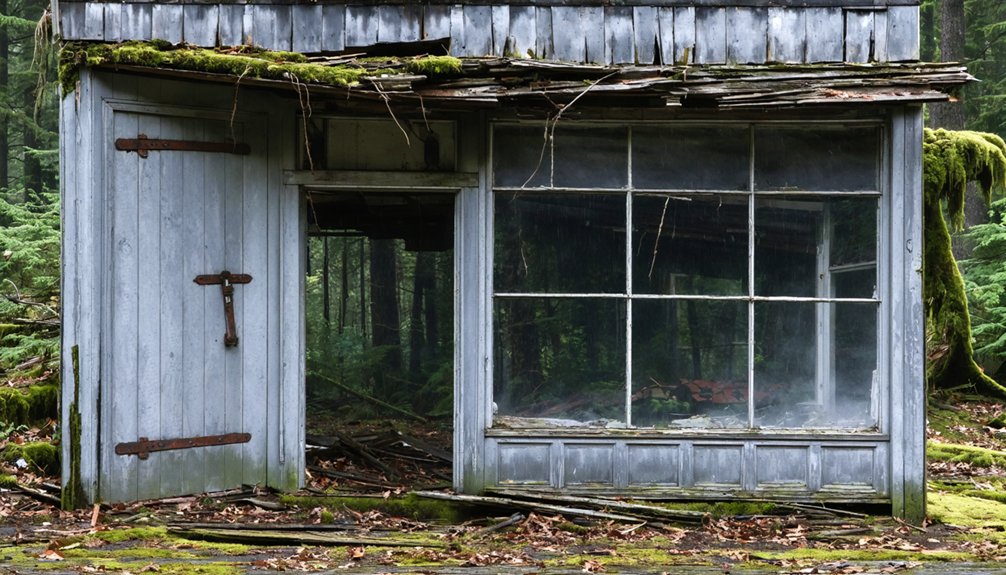
Port Crescent: Logging Town Erased by War
In the 1890s, speculators platted Port Crescent along Crescent Bay’s western shore with grand ambitions that would never materialize. The deep-water harbor promised to anchor a thriving timber economy, with 20,000 lots laid out across 166 blocks to accommodate expected growth.
By the late 1890s, mosquito-fleet steamers served a bustling logging community complete with hotels, saloons, and a long pier for log exports.
Yet the anticipated railroad never arrived, and highways routed south diverted commerce away. Fire consumed most buildings in the 1920s.
Despite promises of prosperity, Port Crescent’s fate was sealed by missed rail connections and rerouted trade routes before fire delivered the final blow.
The wartime impact proved final: during World War II, the Army razed remaining structures to build Fort Hayden’s coastal artillery batteries. Spruce Production Division operations during World War I had earlier brought military presence to Clallam County’s timber communities, foreshadowing the Army’s later commandeering of coastal sites. Drafting of loggers for military service in 1917 disrupted the region’s timber workforce before exemptions were granted for industrial necessity.
Today, only the historic cemetery and scattered concrete bunkers mark where Port Crescent once stood.
Elwha Valley Dam Ruins: Industrial Ghosts Inside the Park
Unlike the vanished timber settlements scattered around the park’s edges, the Elwha Valley preserves concrete remnants of two hydroelectric dams dismantled between 2011 and 2014 in North America’s largest removal project.
You’ll find exposed abutments and spillway segments clinging to Glines Canyon’s walls above the restored river, while downstream near the former Lake Aldwell basin, foundation scars and penstock routes trace the 1910–1913 Elwha Dam’s footprint.
Access depends on seasonal trail closures and ongoing restoration work, as the National Park Service balances public interpretation of this industrial archaeology with ecosystem recovery across 70 miles of reopened salmon habitat. The original 1913 dam operated without fish passage in violation of state law, a decision that devastated salmon runs for nearly a century before the removal project began. The Lower Elwha Klallam Tribe continues to partner with restoration efforts to recover the fisheries that sustained their culture for generations.
Dam Removal History Context
When the Lower Elwha Klallam Tribe filed their motion to intervene with the Federal Energy Regulatory Commission in 1986, they set in motion what would become the largest dam removal project in U.S. history.
The dams had operated illegally for decades—Washington’s 1890 law required fish passage, yet neither structure included ladders.
After three decades of tribal advocacy, the Elwha River Ecosystem and Fisheries Restoration Act authorized federal acquisition in 1992.
Physical dam removal began September 2011 and concluded by September 2014.
During this process, approximately 20 million tons of sediment—two-thirds of the century’s accumulation—rushed downstream.
The ecological recovery you’ll witness today represents freedom restored: salmon populations rapidly rebounded, reaching former spawning grounds within a year of completion.
Native vegetation planted on newly exposed land established rapid growth within two to three years, transforming barren reservoir beds into thriving riparian habitat.
The drainage of Lake Mills and Lake Aldwell created 715 acres of new terrestrial habitat that enhanced conditions for both vegetation and elk populations.
Concrete Foundations and Overlooks
Though bureaucratic decisions demolished the Elwha and Glines Canyon dams between 2011 and 2014, scattered concrete foundations persist throughout the valley—industrial ruins transformed into educational monuments.
You’ll find the most substantial concrete remnants at the former Glines Canyon Dam site, where spillways and structural fragments now serve as interpretive exhibits documenting the restoration. These ruins stand 210 feet above the original riverbed, offering scenic overlooks across reshaped channels where 20 million tons of sediment carved new landscapes.
The visible remnants contrast sharply with regenerating forests—physical evidence of the century when reservoirs flooded tribal homelands and blocked salmon migrations. Park managers preserved these fragments intentionally, letting you witness both industrial overreach and nature’s resilience firsthand. The $325 million project represents the largest dam removal globally, a scale that underscores the monumental effort required to restore what was lost. The Lower Elwha Klallam Tribe is working to reclaim approximately 1,000 acres of project lands that include cultural sites dating back 8,000 years, representing some of the oldest archaeological locations in the Pacific Northwest.
Access Routes and Closures
Vehicle access to the Elwha Valley’s industrial remnants terminates abruptly at Madison Falls parking lot, where Olympic Hot Springs Road meets a permanent closure gate installed after catastrophic flood washouts rendered the pavement impassable.
Beyond this barrier, only bicycles, pedestrians, and stock can proceed into the restoration zone. You’ll navigate approximately 7.5 miles round-trip to reach the upper Glines Canyon Dam site, traversing flood-scoured pavement and utilizing an 0.8-mile bypass trail around the primary washout.
The abandoned ranger station, support buildings, and interpretive overlooks lie scattered along this corridor. Access limitations shift frequently as the Elwha River continues reshaping the valley—check official Olympic National Park updates before departure.
No visitor facilities exist past the gate; you’re entirely self-sufficient in this rewilding industrial landscape. Early mornings provide the most peaceful wildlife spotting opportunities as deer and bird species move through the restoration zone. The Glines Canyon Dam, completed in 1927 and standing 210 feet tall, once loomed 8 miles upriver from its smaller counterpart before deconstruction began in 2011.
Bordeaux: Protected Archaeological Site in Capitol State Forest
Southeast of Olympia in Capitol State Forest, you’ll find Bordeaux—a protected archaeological site preserving the concrete foundations, smokestack, and vault of a logging company town that operated for roughly sixty years until mid-20th-century abandonment.
Unlike most ghost towns, the core townsite sits on private property and land managers explicitly request the public refrain from visiting due to archaeological sensitivity and property rights.
You can still connect with this industrial heritage through archival research and by exploring the broader Capitol State Forest road system that once served the Bordeaux mill’s logging operations.
Company Town Archaeological Remains
Deep in Capitol State Forest southwest of Olympia, the archaeological remains of Bordeaux mark one of the Pacific Northwest’s longest-lived logging company towns, where concrete foundations and a solitary smokestack now stand as weathered monuments to six decades of industrial timber production.
You’ll find moss-covered walls and a reinforced vault structure—likely the company store’s safe—scattered among second-growth timber. These ruins document the Bordeaux Logging Company‘s operations from the early 1900s until mid-century, when exhausted cedar stands forced the mill’s closure.
The archaeological significance lies in subsurface artifact scatters and building footprints that reveal early logging technology and company-town organization. Historical preservation efforts recognize the site’s value for understanding Pacific Northwest industrial heritage, though forest regrowth increasingly obscures these remnants of self-sufficient frontier commerce.
Access Restrictions and Alternatives
Although Bordeaux’s archaeological remains represent one of the Pacific Northwest’s most significant logging company town sites, Washington Department of Natural Resources and private landowners have closed the location to public visitation due to escalating resource damage and safety concerns.
Graffiti, vandalism, litter, and structural instability have prompted strict protection measures prioritizing archaeological preservation over recreational access. You’ll find authorities actively discouraging visits through removed social media directions and public messaging.
Instead, redirect your ghost-town interest toward legally accessible Capitol State Forest destinations: Mima Falls Trail, McLane Creek’s interpretive boardwalks, or Mount Molly’s challenging summit routes all offer rewarding experiences without compromising cultural resources.
For historical context, regional museums provide visitor education opportunities documenting Bordeaux’s logging-era significance.
Respecting closures ultimately protects irreplaceable archaeology for future research and interpretation.
Monte Cristo: Mining Camp Hike East of Granite Falls

The discovery of silver ore on July 4, 1889, transformed a remote Northern Cascade Mountains valley into one of Washington’s most ambitious mining ventures.
By 1894, Monte Cristo boasted over 1,000 residents, 211 claims, and railroad connections drawing Eastern capital—including John D. Rockefeller’s syndicate. The mining history reveals both promise and peril: erratic ore bodies, devastating floods in 1897, and relentless avalanches ultimately defeated the operation by 1920.
Monte Cristo’s boom-to-bust cycle embodied the volatile nature of frontier mining—ambitious capital investment undone by unforgiving geography.
You’ll find Monte Cristo approximately 40 miles east of Everett, accessible via a 4-mile hike along the closed road following South Fork Sauk River.
Though floods in 2003 and 2006 damaged the route, you can still trace the original miners’ path from 130 years ago, where scattered relics and preservation efforts maintain this proof of frontier ambition.
Liberty: Washington’s Oldest Mining Town Still Standing
- Coarse nuggets and crystalline wire gold from ancient Columbia River deposits
- Three-generation family operations rather than transient prospectors
- Century-long mining evolution from placer to hydraulic to dredge operations
- National Register status since 1974 for exceptional mining significance
The original 1890s townsite layout remains intact, preserved by families who never fully abandoned their claims.
Northern State: Institutional Ghost Complex Near Sedro-Woolley
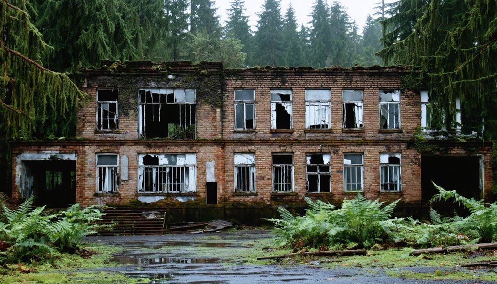
When the Washington State Legislature authorized Northern State Hospital in 1909, they envisioned something fundamentally different from the fortress-like asylums of the era—an agricultural colony where mental health treatment would unfold across farm fields and orchards rather than locked doors.
The Olmsted Brothers designed sprawling grounds without perimeter fences, creating an unusual institutional landscape where patient experiences ranged from therapeutic farm work to brutal experimental procedures like lobotomies.
By mid-century, over 2,700 people lived here under a catastrophic 200:1 patient-doctor ratio. The complex operated as a self-contained town until funding cuts forced closure in 1973.
Today’s partial ruins offer stark history preservation lessons about society’s evolving—and often troubling—approaches to mental health care and individual liberty.
Gold Rush Failures: Chesaw and Barron in North-Central Washington
While Northern State Hospital’s institutional failures unfolded in western Washington’s valleys, a different kind of abandonment scarred the state’s north-central interior.
Chesaw history reveals how gold fever transformed Okanogan County‘s foothills between 1896 and 1900, only to leave hollow promises scattered across the landscape.
Gold fever swept through Okanogan’s foothills for four short years, leaving only broken dreams and empty claims behind.
You’ll find evidence of this mining legacy through:
- Forty buildings erected by 1910 where handshake deals sealed fortunes in saloon-lit rooms
- Chinese and Anglo miners who blasted tunnels chasing silver and gold deposits
- Failed assays that proved ore values weren’t worth extracting
- Abandoned log shacks dotting roadsides near deserted claims
Today, roughly 200 residents maintain what remains of Chesaw, celebrating their 4th of July rodeo amid ghost structures from mining’s boom-and-bust cycle.
Planning Your Ghost Town Route From Park Gateway Cities

Because Olympic National Park’s gateway cities evolved as resource-extraction hubs before tourism, your ghost-town routes naturally radiate from the same industrial arteries that once hauled Douglas fir and cedar to tidewater mills.
Port Angeles anchors hub-and-spoke circuits west along US‑101 and south into Elwha Valley, where rail grades guide you to abandoned camps.
Sequim’s dry corridor opens logging spurs toward foothill company sites—ideal for ghost town photography in stable light.
Port Townsend and Quilcene form a loop gateway linking maritime districts to Hood Canal’s mill ruins.
Forks commands western timberlands where side roads reach coastal logging hamlets.
Few historical signage markers survive, so topographic maps and railroad-grade overlays become your primary wayfinding tools on gravel corridors threading forgotten clearcuts.
Safety and Access Rules for Exploring Abandoned Sites
Your planned route into Olympic’s ghost town corridors demands thorough legal homework before you leave pavement. Access permissions aren’t optional—private inholdings, tribal lands, and corporate parcels require explicit authorization, even when unsigned.
Once cleared, safety precautions become your survival baseline:
- Structural collapse risks: Rotten timbers, failing roofs, and compromised floors dominate abandoned logging camps and mining facilities.
- Hidden fall hazards: Vegetation-obscured mine shafts and prospect pits create sudden vertical drops around former resource towns.
- Toxic legacy materials: Asbestos, lead paint, and chemical residues persist in industrial ruins and historic buildings.
- Zero cell coverage: Olympic’s backcountry eliminates emergency communication—self-reliant navigation and first aid skills aren’t negotiable.
Federal Wilderness regulations prohibit drones and mechanized equipment across 95% of the park, limiting documentation methods at remote sites.
Frequently Asked Questions
Are Any Ghost Towns Actually Located Inside Olympic National Park Boundaries?
No true ghost towns exist inside Olympic National Park boundaries. You’ll find wilderness, hiking trails, and historical significance from former logging camps and the Spruce Railroad corridor, but platted townsites remain outside park limits.
Just like Olympic National Park, ghost towns surrounding Petrified Forest National Park tell stories of human endeavor and the passage of time. These abandoned places offer a glimpse into the past, where visitors can walk among the remnants of what once was, seeing how nature reclaims its territory. Exploring these areas not only enriches your understanding of the region’s history but also enhances your appreciation for the natural beauty that envelops them.
Which Ghost Town Sites Allow Overnight Camping Nearby?
You’ll find camping regulations permit overnight stays near Port Crescent at Salt Creek Recreation Area and Fairholme Campground, both thirty minutes away. The Elwha corridor’s nearby attractions require designated backcountry sites, not roadside camping near abandoned infrastructure.
Can You Visit Ghost Towns Year-Round or Only in Summer?
You’ll find seasonal accessibility varies widely—low-elevation coastal sites stay open year-round, while higher ghost towns face snow closures and impassable roads. Weather considerations demand verifying current conditions before winter exploration attempts.
Do Ghost Town Sites Have Cell Phone Service for Emergencies?
Cell service availability at these remote ghost town sites is extremely limited or nonexistent. You’ll need proper emergency preparedness—carry maps, supplies, and inform others of your plans before venturing into Olympic’s backcountry areas.
Are Dogs Allowed at Ghost Town Sites Near the Park?
Maneuvering a patchwork of rules, you’ll find most ghost town sites near Olympic National Park restrict or prohibit dogs due to private-property closures, archaeological sensitivity, and strict pet regulations—only limited dog friendly trails nearby permit leashed companions.
References
- https://stateofwatourism.com/ghost-towns-of-washington-state/
- https://www.islands.com/1938500/franklin-ghost-town-washington-woodlands-waterfalls-abandoned-mountain-trail/
- https://www.wta.org/go-hiking/hikes/bordeaux-ghost-town
- https://explorewashingtonstate.com/barron-ghost-town-2/
- https://www.tripadvisor.com/Attraction_Review-g28968-d15215289-Reviews-Northern_State_Ghost_Town-Washington.html
- https://www.xexplore.com/port-crescent/
- https://www.youtube.com/watch?v=8IW9xaVfVqQ
- https://www.historylink.org/file/7576
- https://content.lib.washington.edu/cmpweb/exhibits/logging/index.html
- https://paddlingthesalishsea.substack.com/p/crescent-bay-a-historical-overview


