You’ll find several ghost towns within an hour of Park City, most tied to the silver and lead rushes of the 1870s-1880s. Keetley, once a mining camp established in 1875-1876, now lies submerged beneath Jordanelle Reservoir since 1995. Alta in Little Cottonwood Canyon shifted from a 3,000-resident mining hub to a ski area after dwindling to six voters by 1930. Scattered mining remnants along Silver Creek drainage—tailings piles, mill foundations, collapsed adits—mark satellite camps accessible via multi-use trails, though you’ll need to verify ownership and respect posted boundaries before exploring further.
Key Takeaways
- Keetley, a former mining camp and farming colony established in 1875-1876, now lies submerged beneath Jordanelle Reservoir since 1995.
- Alta transformed from a 3,000-resident mining town in 1872 to a ghost town by 1930 before becoming a ski area in 1938.
- Mining remnants near Silver Creek include tailings piles, mill foundations, collapsed adits, and aerial tramway towers accessible via multi-use trails.
- Access ghost town sites through trailheads at Sampson Avenue, King Road, and Silver Star Plaza, staying on marked trails for safety.
- Verify land ownership and respect private property boundaries marked by signs, fences, and locked gates before exploring any sites.
Keetley: The Submerged Town Beneath Jordanelle Reservoir
The waters of Jordanelle Reservoir conceal one of Utah’s most unusual ghost towns—a community that began as a mining camp, transformed into a Japanese American farming colony during World War II, and ultimately vanished beneath the surface when the dam filled in the 1990s.
Keetley history started in 1875–1876 when the site served Park City’s silver and lead mines. Named after Pony Express rider Jack Keetley, the town gained rail access in 1923.
During March 1942’s brief self-evacuation window, Fred Isamu Wada led 126–130 Japanese Americans from Oakland to establish a cooperative farm here. Despite anti-Japanese hostility and poor soil conditions, colonists cleared 150 acres and produced fourteen crop varieties under patriotic “Food for Freedom” banners. Many Japanese farmers returned to the west coast after the war ended.
This submerged heritage represents both mining-era enterprise and wartime resilience. The dam gates closed in 1995, flooding the valley and erasing physical traces of both the mining community and the agricultural cooperative that had occupied this land.
Silver Creek Mining Remnants East of Park City
Following Silver Creek northeast from Park City, you’ll encounter scattered tailings piles, mill foundations, and waste-rock dumps that trace the corridor’s role as the main drainage for Ontario, Silver King Coalition, and other upper-canyon workings from the 1870s through 1982.
These remnants—stone footings, ore-bin platforms, and altered stream meanders—lie along the historic Union Pacific corridor near I-80, where gravity mills and flotation plants once discharged decades of polymetallic ore processing into the creek.
Access requires maneuvering a patchwork of reclaimed industrial sites, modern commercial development, and public right-of-way segments that still reveal the district’s production of 253 million ounces of silver and 2.7 billion pounds of lead. The entire mining district developed on a spur extending from Dayton Peak, which connects the Wasatch Range to the Uinta uplift approximately 30 miles southeast of Salt Lake City. The district’s origins trace back to 1868, when three soldiers discovered silver and lead deposits that would transform the region from wilderness into one of Utah’s most productive mining centers.
Historic Mining Operations Overview
When soldier-prospectors from Fort Douglas ventured into the Bonanza Flat area east of present-day Park City in late 1868, they uncovered silver and lead deposits that would transform the remote Utah canyon into one of the West’s most productive mining districts.
The Flagstaff Mine, staked in October 1868, launched commercial operations in 1871. George Hearst’s 1872 acquisition of the Ontario Mine for $27,000 established the camp’s reputation.
The Silver King Coalition Mine emerged as the second major discovery that contributed to Park City’s mining prosperity, with Thomas Kearns and David Keith consolidating claims on Treasure Hill during the 1880s. Molten rock had forced superheated mineral solutions into earth fissures created when the Wasatch and Uinta Mountains rose millions of years ago, forming the veins of silver, gold, lead, and zinc that prospectors would later exploit.
Accessing Ruins and Trails
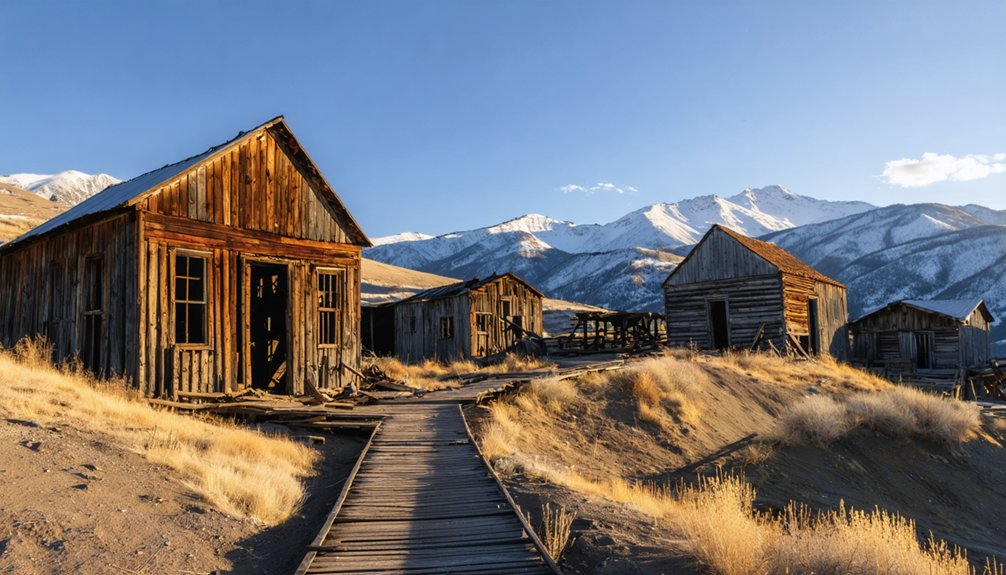
East of Park City’s historic Main Street, a network of multi-use trails threads through the Silver Creek drainage and Woodside Gulch, where remnants of the Silver King Coalition‘s vast mining operation still punctuate the mountainside.
You’ll find trailheads along Sampson Avenue, King Road, and Silver Star Plaza, with the 2.5-mile Bonanza Mine Trail offering the most direct route to the shaft house, mill foundations, and aerial tramway towers spanning the 31-acre National Register district.
Trail navigation requires attention—digital maps prove essential for locating specific ruins and managing junctions.
While the sites carry immense historical significance, you can’t enter structures due to safety concerns and preservation mandates. Exterior viewing only.
The landscape itself tells the story: unstable timbers, hidden shafts, and over 1,200 miles of underground tunnels demand cautious exploration from marked pathways. The processing pattern remains clearly evident across the terrain, where ore production facilities connected shaft houses to mills through an intricate system of tramways and chutes. For optimal exploration conditions, plan your visit during early morning or late afternoon when lighting enhances the photographic opportunities and fewer visitors share the trails.
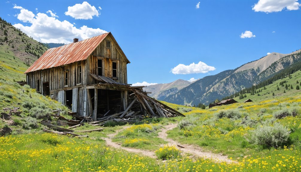
Alta: A Living Ghost Town in Little Cottonwood Canyon
Perched near the upper end of Little Cottonwood Canyon at roughly 8,500 feet elevation, Alta began its transformation from wilderness to boomtown when prospectors discovered silver in the area in 1864.
By 1872, roughly 3,000 residents occupied about 180 buildings in what became a thriving mining center. However, fire, devastating avalanches in the late 1880s, and dwindling silver output gradually emptied the town.
By 1930, only six registered voters remained in this virtual ghost town.
Alta history took an unexpected turn when longtime miner George Watson deeded about 700 acres to the U.S. Forest Service in 1937 for ski-area development.
The Alta Ski area officially opened in 1938, breathing new life into the abandoned mining site and creating what you’ll find today: a unique “living ghost town” where winter sports replaced silver extraction. The resort expanded significantly in 1960 to accommodate the growing popularity of skiing. During its peak production years in the 1870s, the mines in Little Cottonwood Canyon generated $13.5 million in silver and other precious metals.
Eureka and Ophir: Semi-Ghost Towns Within Day-Trip Range
Beyond Alta’s snowy slopes, two fascinating semi-ghost towns await exploration within easy day-trip distance of Park City, each offering a distinctly different glimpse into Utah’s mining heritage.
As you venture forth, exploring ghost towns in Utah allows for a deep dive into stories of resilience and the rugged life of miners. Each site features remnants of old storefronts and crumbling infrastructure, inviting curiosity and reflection. The stunning landscapes surrounding these towns provide a stark contrast to the echoes of the past, making for an unforgettable adventure.
Eureka history reveals a former Tintic Mining District powerhouse that once housed nearly 4,000 residents around 1910, now home to just 600 souls among National Register-listed buildings. You’ll find the Tintic Mining Museum, Old Eureka Jail, and reputedly haunted Gatley Building along its preserved Main Street.
Meanwhile, Ophir preservation efforts have maintained clusters of 1870s-era cabins and mine structures in Tooele County’s Oquirrh Mountains.
Both towns offer authentic time-capsule experiences—Eureka with its “living museum” atmosphere and nearby Silver City Cemetery, Ophir through its intimate historic district frozen in mining-era character.
Exploring Summit County’s Mining Heritage and Abandoned Camps
While Park City’s transformation from boom to bust and back again captures most visitor attention, Summit County’s broader mining landscape tells a more complex story of silver strikes, coal seams, and vanished camps scattered across remote canyons.
You’ll discover mining artifacts scattered across Grass Creek Canyon and Chalk Creek Canyon, where coal operations once fueled railroads and smelters. These sites hold tremendous historical significance, documenting the territorial legislature’s 1854 reward program and subsequent extraction economy.
Key remnants include:
- Collapsed adits and waste rock piles marking satellite mining camps
- Foundations from company towns serving Wasatch (Weber) mine operations
- Aerial tramway towers from Park City’s extensive underground workings
- Rockport’s submerged remains beneath Rockport Reservoir
- Transportation corridors through Echo Canyon linking mines to markets
Visitor Tips for Safe and Respectful Ghost Town Exploration
When exploring ghost towns around Park City, you’ll preserve both the sites and your safety by staying on marked trails and existing roads rather than creating new paths across fragile mining landscapes.
Always verify land ownership through Summit County records or Forest Service maps before your visit, since many historic townsite parcels remain in private hands despite their abandoned appearance.
If you encounter fencing, signage, or locked gates—even on what appears to be public land—treat these boundaries as absolute limits and explore only the accessible portions of each site.
Stay on Established Routes
Exploring ghost towns near Park City requires you to stay on mapped and signed roads and trails at all times.
Designated Forest Service routes and official MVUMs show legal access corridors that incorporate essential safety precautions while protecting fragile historic sites. Proper route planning prevents erosion damage, protects cryptobiotic soils, and helps you avoid open mine shafts and unstable slopes common throughout Utah’s mining districts.
Key principles for staying on established routes:
- Use numbered Forest Service or BLM roads shown on current agency maps and apps
- Treat gated or bermed side roads as closed even when tire tracks are visible
- Park only at official pullouts near sites like Alta and Silver Creek
- Avoid creating social trails across vegetation or tailings piles
- Check seasonal closures and mud conditions before departure
Respect Private Property Boundaries
Staying on marked routes keeps you safe, but even public roads sometimes lead directly to private land where legal access ends. Many Utah ghost towns sit fully or partly on private property or active mining claims. County assessor GIS maps and BLM interactive maps help you distinguish private parcels from federal land around historic sites.
“No Trespassing” and “Private Property” signs mark legal limits—entry beyond these points triggers criminal trespass charges. Fences, locked gates, and cattleguards indicate property boundaries you can’t bypass.
Sites like Winter Quarters allow only distant viewing from public roads.
When unclear, contact sheriff offices or local historical societies for current access guidance. Practicing ghost town etiquette means respecting private land access restrictions, even when structures appear abandoned.
Frequently Asked Questions
Are Any Ghost Towns Near Park City Accessible in Winter?
Yes, you’ll find winter accessibility at Park City’s historic Main Street, Keetley townsite off Highway 40, and Alta’s mining ruins. Ghost town activities include snowshoeing to remnants and exploring preserved structures via plowed routes.
Can I Legally Metal Detect at Abandoned Mining Sites?
No, you can’t legally metal detect at most abandoned mining sites. Like striking a vein only to find it’s claimed, metal detecting regulations and historical mining practices on BLM and Forest Service land prohibit collecting artifacts over 100 years old.
Which Ghost Town Is Best for Photography Near Park City?
Ophir ghost town offers you the best photography near Park City—just 90 minutes away with restored buildings, mining relics, and scenic viewpoints. Follow photography tips: shoot during golden hour when canyon light enhances textures and architectural details.
Do Any Ghost Towns Near Park City Offer Guided Tours?
Like prospectors panning for gold, you’ll find guided tour options scarce at true ghost towns near Park City. Instead, Park City’s historic district offers walking tours with mining-era historical significance, while authentic ghost towns remain self-guided adventures.
Are There Ghost Towns With Original Artifacts Still Visible?
Yes, you’ll find original artifacts at Silver Creek, Alta’s mining remnants, and Keetley. Rusted tools, ore carts, and collapsed structures remain in situ, preserving the historical significance of Utah’s 19th-century mining boom across unmarked, accessible terrain.
References
- https://en.wikipedia.org/wiki/List_of_ghost_towns_in_Utah
- https://435locals.com/ghost-towns-near-zion/
- https://www.utahsadventurefamily.com/5-ghost-towns-in-utah-for-families/
- https://www.atlasobscura.com/things-to-do/utah/ghost-towns
- https://jzvacationrentals.com/the-forgotten-ghost-towns-near-park-city-and-how-to-visit-them/
- https://www.visitutah.com/things-to-do/history-culture/ghost-towns
- https://www.ksl.com/article/51308628/restored-utah-ghost-towns-that-should-be-on-your-summer-travel-bucket-list
- https://film.utah.gov/spooky-rural/
- https://townlift.com/2025/09/keetley-utah-the-sunken-town-below-deer-valleys-historic-ski-resort-expansion/
- https://hebervalleylife.com/beneath-the-surface/


