You’ll find several ghost towns within 50 miles of Pinnacles National Park, most conspicuously New Idria—a mercury mining camp 45 miles southeast that housed 4,000 residents at its peak and operated from 1854 to 1972. The Gabilan Range contains dozens of smaller abandoned prospect sites and mining camps from the 1860s-1900s, while Bear Valley and Arroyo Seco drainages preserve dryland homestead ruins from the 1870s. Access requires traversing private ranch land and BLM tracts, with many sites presenting mercury contamination hazards. The historical landscape below reveals California’s frontier mining legacy in striking detail.
Key Takeaways
- New Idria, a mercury mining ghost town with over 100 structures, is located in southeastern San Benito County near Pinnacles.
- The Gabilan Range contains dozens of abandoned mining camps from the 1860s-1900s with remnants like collapsed tunnels and shafts.
- Rootville preserves overgrown tailings and caved tunnels from 1860s-1870s mining ventures in the region.
- Most ghost town sites are on private ranches or BLM land, requiring permission and posing safety hazards like open shafts.
- New Idria is an EPA Superfund site with mercury contamination; federal agencies recommend avoiding contaminated areas.
New Idria: California’s Premier Mercury Mining Ghost Town
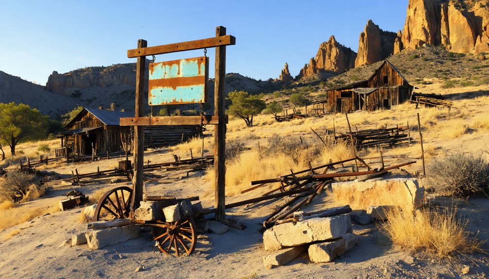
Deep in the rugged backcountry of southeastern San Benito County, the ghost town of New Idria stands as a tribute to California’s mercury mining legacy.
You’ll find over 100 weathered structures marking where 4,000 miners once extracted quicksilver using overhand stoping mining techniques and pneumatic drills through 15–20 miles of underground tunnels.
Founded in 1854, this California Historical Landmark became the nation’s largest mercury producer between 1957–1959, yielding over half a million flasks before closing in 1972.
The mine’s extraction process involved crushing and roasting cinnabar ore, producing between 0.5 to 2 million tons of waste that still blankets the surrounding landscape.
During World War I, New Idria served as the largest supplier of mercury to the U.S. Department of Defense.
Today, ghost town legends surround the abandoned post office, church, and calcine-covered slopes.
Though fenced off since EPA Superfund listing in 2011 due to mercury contamination, New Idria remains a compelling representation of industrial ambition and consequence.
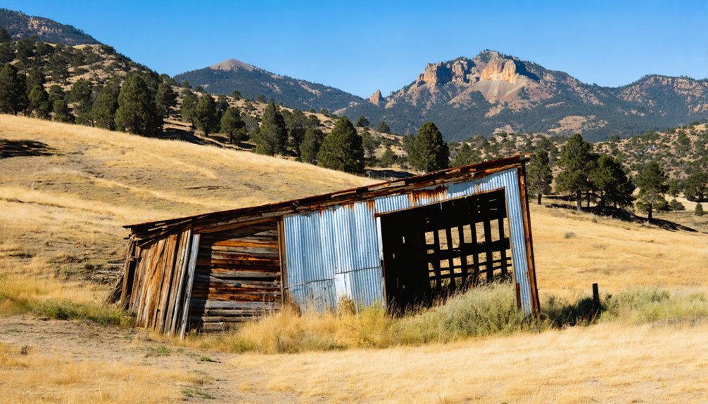
Mining Camps and Prospect Sites in the Gabilan Range
Unlike New Idria’s concentrated industrial complex, the Gabilan Range west of Pinnacles holds dozens of scattered prospect sites that never advanced beyond exploratory stages.
You’ll find the remnants of this intermittent activity—collapsed adits, shallow shafts, and overgrown waste dumps—distributed across remote ridges where prospectors tested altered volcanic rocks and quartz veins from the 1860s through the early 1900s.
Contemporary mining reports and Monterey County claim records document these efforts as largely unsuccessful attempts to locate payable gold, copper, and base-metal deposits in formations peripheral to the Pinnacles volcanic field. The Rancho Cienega del Gabilan, spanning nearly 49,000 acres of the Gabilan Range, formed part of the broader landscape where these prospecting activities occurred across both Monterey and San Benito counties. The underlying geology consists of granite and schists that form the basement of the Gabilan Range, occasionally interspersed with metamorphosed limestones that attracted mineral exploration.
Quicksilver and Chromite History
While the volcanic spires and chaparral ridges of Pinnacles National Park draw today’s visitors, the broader Gabilan Range sheltered a parallel history of industrial extraction that shaped settlement patterns and left scattered ruins across the backcountry.
You’ll find that quicksilver production dominated the eastern slopes, where New Idria‘s underground workings ranked second only to New Almaden statewide. Miners followed cinnabar veins through Franciscan cherts and serpentinite, roasting ore in furnaces that condensed mercury vapor into iron flasks bound for Nevada’s Comstock and Sierra goldfields. New Almaden itself operated for 135 years, establishing itself as California’s most productive mine before closing. Workers extracted ore from over 100 miles of tunnels reaching depths of 2,300 feet into the Cinnabar Hills.
Meanwhile, chromite deposits formed lenses within ultramafic bodies along the range crest, spurring wartime prospecting booms that left open cuts and short adits scattered through the serpentinite belt between San Benito and Monterey counties.
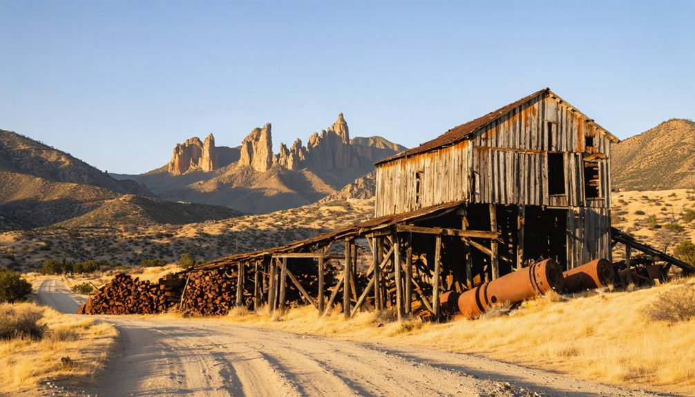
Remaining Foundations and Adits
Scattered across the chaparral-covered slopes west of Pinnacles, the physical remnants of 1860s–1870s mining ventures survive as low-relief archaeology rather than standing structures.
You’ll find Rootville’s traces reduced to overgrown tailings and a few caved tunnels, accessible only to determined off-trail hikers willing to bushwhack through dense brush.
The Copper Mountain Mining Company’s adits—driven into mineralized rhyolite dikes roughly one mile west—remain as short, collapsed portals with small waste dumps marking unsuccessful exploration.
Miners Gulch preserves shallow prospect pits and hand-stacked cobble bars from limited placer efforts.
Early extraction techniques included arrastras that ground ore with heavy stones, evidenced by the discovery of over fifty arrastra beds throughout the Gavilan area.
Across the broader Gabilan Range, scattered test pits, trench cuts, and occasional hoist foundations document persistent but futile prospecting through the early twentieth century.
These sites reflect the geological diversity characteristic of lode deposits in numerous mountain ranges that defined California’s mining frontier.
This mining heritage exists now as fragments awaiting your adit exploration and archaeological interpretation.
Access and Safety Concerns
Because the former mining camps and prospect sites occupy a fragmented patchwork of private ranches, Bureau of Land Management tracts, and county holdings, you’ll face significant legal and logistical barriers before setting foot in these historic areas.
Access routes to places like Copper Mountain Mining Company prospects remain unsigned, gated, or decommissioned, with no maintained public roads. Legal restrictions intensify on patented and active mining claims—entry without permission violates federal law.
Beyond bureaucracy, the terrain itself punishes exploration: chaparral hides collapsed shafts, decayed cribbing, and voids that collapse underfoot. Steep canyons amplify flash-flood and rockfall hazards. Like the historic Kelsey Mine operations, these sites feature crevice widths varying from mere seams to several feet, creating unpredictable underground spaces prone to sudden collapse.
Summer heat, scarce water, and minimal cellular coverage compound risk. Limited emergency response times mean self-reliance isn’t optional—it’s survival.
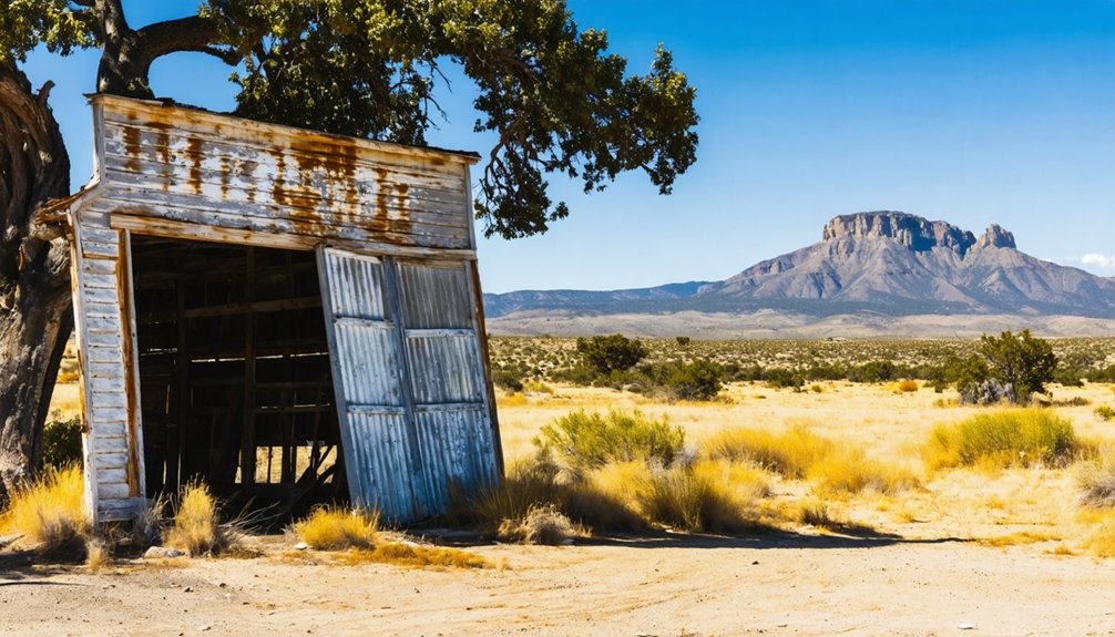
Abandoned Homesteads and Ranching Settlements
You’ll find the most tangible remnants of Pinnacles-area settlement not in formal towns but in scattered ranching homesteads established across Bear Valley and adjacent drainages during the late 1800s.
Homesteaders selected alluvial valley bottoms along the Highway 25 corridor and Arroyo Seco for dryland farms and seasonal stock operations, leaving behind cabin foundations, corral posts, and abandoned orchards documented in National Park Service cultural landscape inventories.
These isolated claims—including the Bacon Ranch opposite the park’s eastern entrance—reveal a pattern of marginal agriculture sustained by hand-dug wells and creek diversions until drought, poor soils, and isolation forced most families to abandon their holdings by the early twentieth century. The Civilian Conservation Corps improved trails and facilities in the park area from 1933 to 1942, long after most homesteaders had departed.
Bear Valley Dryland Homesteads
The Bear Valley dryland homesteads represent one of California’s lesser-known settlement experiments, where families claimed 160-acre parcels under the Homestead Act of 1862 in an area approximately 45 miles northeast of San Diego.
You’ll find these properties occupied land outside Spanish grant boundaries, making them available for independent settlement. The Fickert family established one of the earliest documented claims in 1869, pioneering dryland agriculture techniques in this challenging environment.
By 1876, settlers had organized basic infrastructure, with the Fleishman property hosting the valley’s first school. These homesteaders operated without reliable irrigation systems initially, developing self-sufficient operations while private homes doubled as churches and schools.
The settlement pattern reflected the full evolution from initial land claims through established ranching operations before eventual abandonment.
Seasonal Sheep and Cattle Outcamps
From the 1870s through the early 1900s, ranchers established temporary seasonal camps throughout the grasslands and oak woodlands surrounding present-day Pinnacles National Park, creating a network of now-abandoned structures that served transient herding operations.
While detailed documentation of specific outcamps remains limited, ranching history in this region reflects broader patterns of seasonal grazing across California’s Coast Ranges.
You’ll find traces of these operations scattered throughout the backcountry:
- Stone foundations and corrals marking temporary shepherd shelters
- Abandoned spring developments and livestock watering systems
- Remnant fencing delineating historical grazing boundaries
- Earthen depressions where seasonal camps once stood
These ephemeral sites represent the mobile nature of early livestock operations, where freedom to move herds with changing seasons defined success.
Arroyo Seco Ranching Communities
Beyond the valley floor’s fertile bottomlands, homesteaders carved out marginal cattle ranches along the Arroyo Seco drainage and its junction with the western Gabilan foothills from the 1870s through the early twentieth century.
You’ll find evidence of this ranching heritage on alluvial benches above flood-prone channels, where families raised stock on oak savanna and chaparral despite low carrying capacities and thin soils.
Scattered homesteads—not nucleated towns—defined community dynamics, with wagon tracks linking isolated claims to Greenfield and Soledad markets. Hand-dug wells, silted stock ponds, and earthen berms mark former camps where cowboys ran cow-calf operations across steep terrain.
Federal conservation efforts near Pinnacles eventually constrained new entries, leaving these remote settlements to fade as transport costs and seasonal water scarcity overwhelmed subsistence economics.
Historic Stage Stops and Wagon Route Relics
While precise documentation of stage stops near Pinnacles remains scarce in existing archives, the Butterfield Overland Mail route passed approximately 30 miles west through the Salinas Valley between 1858 and 1861, establishing a network of relay stations that served the region’s early settlers.
You’ll find remnants of historic transportation corridors throughout the Gabilan Range:
- Stone foundations marking forgotten waystation locations along abandoned routes
- Wagon wheel ruts carved into sandstone near water sources
- Hand-dug wells that supplied livestock during grueling crossings
- Weathered hitching posts at isolated ranches that once provisioned travelers
These artifacts represent California’s transformation from Mexican territory to American statehood.
Each relic connects you to pioneers who chose uncertainty over constraint, trading comfort for opportunity across unforgiving terrain where freedom meant self-reliance.
Accessing Ghost Town Sites Near Pinnacles
Discovering these historic stage stops and wagon route relics is only the beginning—reaching the actual ghost town sites scattered across the Central Coast and inland ranges requires understanding the complex patchwork of land ownership and access regulations that govern California’s abandoned settlements.
BLM-managed mine ruins generally permit dispersed hiking unless signed otherwise, while ghost town regulations on state park lands like Bodie enforce entrance stations and strict structure-entry prohibitions.
National forest camps follow standard backcountry rules: heed seasonal closures and respect cultural sites. Private remnants demand you stay on public easements without explicit permission.
Access restrictions extend beyond ownership—graded dirt approaches turn washboarded, unmaintained spurs need 4WD, and winter snow blocks high-elevation roads.
USGS quads reveal labeled townsites where highway maps end, essential when cell service vanishes.
Safety Hazards and Environmental Concerns
Visiting ghost towns in the Pinnacles region exposes you to serious hazards that far outlast the communities themselves.
Mercury mining’s legacy demands rigorous safety precautions before you explore:
- Open shafts and adits concealed by brush can drop you into oxygen-deficient chambers or unstable stopes that collapse after rain or seismic activity.
- Mercury-contaminated tailings and calcines leach methylmercury into streams, creating bioaccumulation risks documented in Coast Range watersheds.
- Rotted structures and debris fields hide puncture hazards, unstable headframes, and camouflaged wells that won’t support your weight.
- Fire-prone chaparral surrounding sites ignites easily from vehicle sparks or campfires in this tinder-dry terrain.
These environmental impacts persist decades after abandonment.
Federal agencies recommend staying out entirely—trespassing into workings or disturbing contaminated soils threatens both your safety and fragile ecosystems downstream.
Comparing Central California Ghost Towns to Desert Icons
California’s ghost towns diverge sharply along geographic lines, creating two distinct preservation landscapes that yield different exploration experiences.
Among these are the ghost towns near Redwood National Park, which offer a unique glimpse into the region’s rich history. Visitors can wander through the remnants of old mining facilities and wooden structures, each telling stories of a bygone era. The lush backdrop of towering redwoods adds a striking contrast to the starkness of these abandoned spaces, making exploration both haunting and beautiful.
Central California’s Mother Lode settlements like Mokelumne Hill ($30 million in gold) and Silver Mountain City experienced gradual population shifts rather than complete abandonment. You’ll find miners relocated to adjacent areas, moving entire buildings when deposits declined.
Unlike desert boomtowns that emptied overnight, Mother Lode miners dismantled their settlements piece by piece, hauling buildings to new strikes.
Desert Ghosts like Bodie and Cerro Gordo tell different stories. Bodie’s 10,000 residents vanished within decades after exhausting $34 million in gold reserves. Darwin swelled to 45,000 by 1877 before three fires erased it entirely.
Cerro Gordo, perched at 8,500 feet, remains California’s best-preserved ghost town despite extreme isolation. Desert settlements emptied rapidly—Ballarat’s 500 residents abandoned hotels and saloons once Panamint Mountains gold disappeared, leaving stark architectural remnants.
Preserving Historical Fabric: Ethics and Best Practices
When the National Park Service acquired Elkmont’s 70 historic buildings after leases expired in 1992, it established preservation protocols now applied across federal lands including Pinnacles National Park.
You’ll find ethical considerations embedded in every restoration decision, balancing public access against structural integrity.
The Civilian Conservation Corps model from 1933-1942 demonstrates enduring preservation techniques:
- Stone facilities constructed from local materials in 1936-37 remain structurally sound
- Trail infrastructure requires minimal maintenance after 80+ years
- Bear Gulch Reservoir dam continues functioning without major intervention
- Indigenous participation in contemporary restoration honors cultural heritage
At Pinnacles, documented archaeological sites spanning 2,000 years demand careful stewardship.
Chalon and Amah Mutsun tribal members now contribute restoration expertise, ensuring preservation respects both natural resources and ancestral connections predating 1908 federal designation.
Research Resources for Ghost Town Exploration
Before you set foot in the field, extensive archival research will reveal settlement patterns invisible on modern maps. County recorder offices hold parcel histories and subdivision plats documenting abandonment timelines.
The BLM’s General Land Office database provides original patents and mining claim boundaries that establish public versus private land status—critical for legal access.
USGS topographic map comparisons expose vanished sites, while the Mineral Resources Data System georeferenced mines that anchored ephemeral camps.
State archives preserve newspapers and photographs capturing boom-to-bust cycles. These sources strengthen ghost town preservation efforts by grounding historical archaeology in documented context.
You’ll differentiate genuine townsites from folklore, identify structural remnants worth protecting, and navigate ownership complexities before you ever shoulder a pack.
Frequently Asked Questions
Are There Any True “Boomtowns” in the Pinnacles Area’s History?
No true boomtowns existed in Pinnacles’ mining history. You’ll find only Rootville—a short-lived 1870s camp peaking around 1874—in documented sources. The region’s ghost towns history shows minor local booms, not major urban centers.
How Did Pinnacles National Park Creation Affect Nearby Settlements?
Monument and park designations didn’t cause settlement decline—you’ll find no abandoned towns directly attributable to park impact. Federal withdrawals simply redirected growth toward existing communities like Hollister, preventing new settlements from forming.
Can You Camp Overnight Near Ghost Town Sites?
You’ll find camping regulations permit dispersed overnight stays on BLM land near ghost towns like Trona Pinnacles, but ghost town etiquette and trespassing laws prohibit camping directly among historic ruins on private or protected sites.
What Artifacts Are Legal to Photograph Versus Collect?
You can photograph all historic artifacts in place, but you can’t legally collect anything over 50-100 years old from public lands. Legal guidelines and ethical considerations both emphasize documenting heritage without disturbing it.
Which Ghost Towns Have the Most Visible Remaining Structures?
Ballarat offers you the most visible ruins—an intact stone jail, general store, and cemetery frozen in time. Trona’s occupied blocks display historical significance through weathered homes and industrial towers. Keeler and Ashford Mill preserve distinct structural footprints.
References
- https://www.legendsofamerica.com/ca-deathvalleyghosttownscalifornia/
- https://californiathroughmylens.com/bodie-ghost-town/
- https://www.flyingdawnmarie.com/new-blog/california-ghost-towns
- https://www.barbaranusselphotography.com/blog/2017/4/20/wildflowers-and-ghost-towns-a-road-trip-through-central-california
- https://www.youtube.com/watch?v=bof74XQmKx4
- https://www.tripadvisor.com/ShowUserReviews-g33190-d2263403-r127382530-Trona_Pinnacles-Trona_California.html
- https://www.youtube.com/watch?v=Z7zhkjy5HGU
- https://en.wikipedia.org/wiki/New_Idria_Mercury_Mine
- https://sanbenito.com/new-idria-history-bustling-mine-became-home-to-contaminants/
- https://benitolink.com/veins-of-cinnabar-found-by-mistake-helped-define-the-regions-early-economy/


