
You’ll find exceptional ghost towns within an hour of Salida, with St. Elmo being the crown jewel—nearly 40 original buildings still standing at 9,961 feet in Chalk Creek Canyon. Beyond St. Elmo, you can explore the Mary Murphy Mine ruins at Romley, the high-elevation railroad remnants at Hancock, and the Alpine Tunnel at 11,612 feet. North of town, Turret and Bonanza offer glimpses into 1880s silver boom days. The journey requires different vehicle capabilities depending on your destination, and understanding seasonal access patterns guarantees you’ll experience these time-frozen settlements at their finest.
Key Takeaways
- St. Elmo, established in 1880, is the best-preserved ghost town with nearly 40 original buildings and year-round access.
- Hancock sits at 11,000 feet elevation and requires 4WD vehicles, with only scattered ruins and a saloon foundation remaining.
- Bonanza City, founded in 1880, once housed 1,500 residents and now has only 16, making it Colorado’s second-smallest municipality.
- Best visiting window is late June to early October when high-elevation roads are clear and accessible for exploration.
- Routes split between Chalk Creek Canyon corridor (west) and Ute Trail country (north), requiring different vehicle capabilities.
St. Elmo: Colorado’s Best-Preserved Mining Ghost Town
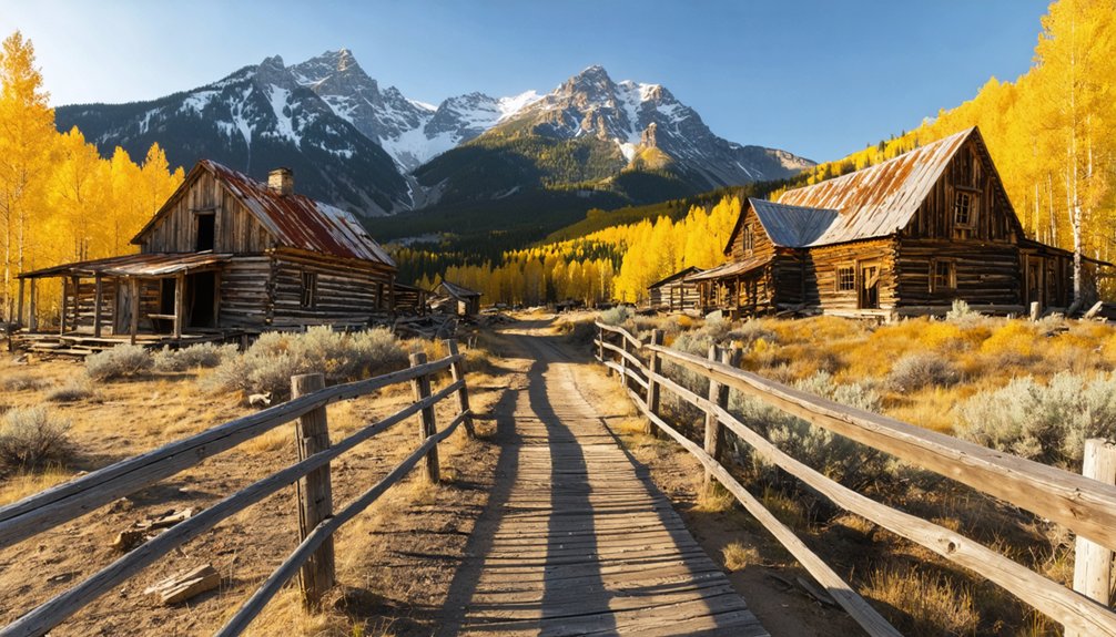
Perched at 9,961 feet in the Sawatch Range’s Chalk Creek Canyon, St. Elmo’s history began in 1880 as a booming gold and silver mining town called Forest City.
You’ll discover nearly 40 original buildings standing from an era when 2,000 residents filled five hotels, multiple saloons, and dance halls. The Denver, South Park and Pacific Railroad made it an essential supply hub until 1922, when the last train departed—legend says the remaining residents rode out and never returned.
Today, you can explore this National Register Historic District where roughly 10 hardy souls still reside.
St. Elmo remains a living ghost town where history meets present-day mountain life at nearly 10,000 feet elevation.
The Mary Murphy Mine alone extracted 220,000 ounces of gold between 1870 and 1925, testament to the area’s rich mineral deposits.
Ghost town legends persist, including tales of Annabelle Stark’s spirit watching over the general store her family preserved for decades.
Despite a devastating 2002 fire, St. Elmo remains Colorado’s most authentic mining-era ghost town. The St. Elmo General Store continues operating as an active business, selling antiques and snacks to visitors during the summer months.
Romley and the Mary Murphy Mine
Just three miles above St. Elmo, you’ll discover Romley’s fading footprint high in Chalk Creek Canyon. Founded in 1881 as a company town, it housed workers for the legendary Mary Murphy Mine—the district’s largest producer.
Romley history includes colorful nicknames: Murphy’s Switch and Red Town, earned from its crimson-painted buildings clustered along the Denver, South Park & Pacific Railroad. At peak, 400 to 1,000 residents supported a thriving community with schools, saloons, and blacksmith shops.
Mary Murphy production exceeded $60 million in gold, silver, lead, and zinc over decades of operation. The mine’s tramway plunged nearly 5,000 feet to the mill below.
Today, weather-beaten ore tipples and the historic railroad bridge stand as monuments to this remote canyon’s boom-and-bust legacy. The town featured essential amenities including a post office and boarding house before its eventual decline. The historic Marley Bridge connects visitors to the Mary Murphy Mine’s storied past.
Hancock: A High-Elevation Railroad Camp
Five miles deeper into Chalk Creek Canyon beyond St. Elmo, you’ll discover Hancock’s ghostly remnants at 11,000 feet. This railroad camp sprang up around 1880 as crews pushed the Denver, South Park & Pacific toward Alpine Tunnel.
Hancock history reveals a tough settlement of 200 souls—mostly railroad laborers and miners enduring brutal winters and thin air. By 1881, stores, saloons, and a telegraph office lined the townsite, creating the last supply point before the tunnel’s eastern portal. The settlement also included a wood frame depot that served arriving trains.
Railroad legacy defines everything here; when Alpine Tunnel closed in 1910, Hancock’s purpose vanished overnight. The town served as a vital supply depot for workers and travelers navigating the treacherous mountain pass. Today you’ll find just a single saloon foundation and scattered ruins—silent testimony to the fierce determination required to conquer Colorado’s Continental Divide.
Alpine Tunnel Area and Historic Railway Remains
Beyond Hancock’s scattered ruins, the crown jewel of this high-country railroad adventure awaits: Alpine Tunnel itself, a 1,805-foot bore punched through the Continental Divide at an oxygen-starved 11,612 feet.
You’ll discover the highest railroad tunnel ever built in North America, driven through unstable boulders and decomposed granite in just 699 days starting in 1880. This Historic Engineering marvel required 400,600 feet of California redwood timbers to prevent collapse.
The Alpine Tunnel operated from 1882 until abandonment in 1910, with trains crawling through in 55 minutes.
Today, you can hike the old railroad grade past dramatic dry-stacked “Palisades” walls—mortarless stone engineering clinging to sheer cliffs. The west portal remains accessible via a rough road leading to a restored train station, though the east portal has collapsed over the decades. Snow sheds stretching 650 feet on the western approach protected against the deadly avalanches that plagued winter operations.
Thirteen miles earned National Historic District status in 1996, preserving this tribute to nineteenth-century determination.
Turret: Where Old West Meets Modern Development
Where Cat Creek valley cradles the eastern slopes of the Sawatch Range, Turret emerged from Peter Schlosser’s vision in 1897, transforming a timber camp called Camp Austin into a bustling mining community of 500 souls by 1902.
You’ll discover a living ghost town where mining heritage breathes through original log structures, now standing alongside modern mountain homes. The town’s architectural preservation rules mandate that renovations maintain authentic log cedar board-on-board construction, ensuring historical integrity remains visible from public roads.
Though the 1939 post office closure and 1944 wartime mining halt ended Turret’s boom era, today’s private ownership has revitalized this settlement twelve miles north of Salida. The Vivandiere and Gold Bug mines drove the original mining operations that established the town west of Cameron Mountain.
You can glimpse Emil Becker’s rebuilt Sample Room Saloon and restored buildings along the scenic gravel road winding through Collegiate Peaks territory. The Gold Bug mine produced exceptional amounts of gold from solid granite formations, establishing Turret as a significant producer in the district.
Bonanza and the Northern San Luis Valley Mining District
While Turret clung to the Collegiate Peaks’ eastern flanks, Salida resident Tom Cooke’s 1880 horse-hunting expedition northwest through the northern San Luis Valley led him to far richer quarry—silver ore deposits at the head of Kerber Creek that sparked the founding of Bonanza City.
The name itself promised wealth, derived from Spanish for an exceptionally large mineral deposit. That promise materialized rapidly. By 1882, Bonanza history records 1,000-1,500 residents supporting 36 saloons, 7 dance halls, and 4 smelters at 9,500 feet elevation.
Silver mining produced thousands of claims across the district, where Bonanza outlasted rival camps Exchequer, Kerber City, and Sedgwick. The Rawley Mine became the district’s dominant producer until 1930.
Today’s 2010 census counted just 16 residents—Colorado’s second-smallest municipality clinging to incorporated status.
Planning Your Ghost Town Tour From Salida
Your ghost town adventure from Salida begins with careful route planning, since the region’s mining camps scatter across two distinct corridors—Chalk Creek Canyon to the west and the Ute Trail country to the north.
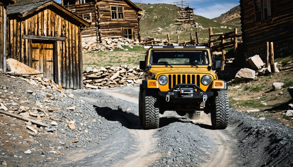
You’ll need to match your vehicle’s capabilities to each destination, as St. Elmo welcomes standard passenger cars while remote sites like Hancock demand 4WD and serious clearance.
Timing matters deeply in these high-elevation districts, where summer’s open roads give way to winter’s snowpack and spring’s axle-deep mud, shaping which camps you can reach and how long each journey takes.
Best Routes and Roads
Since most ghost towns near Salida require traversing unpaved mountain roads and varying elevations, you’ll want to plan your routes carefully before setting out.
The most accessible option is St. Elmo via County Road 162, where year-round plowing guarantees freedom to explore regardless of season. You’ll drive 11 miles west from Mt. Princeton Hot Springs Resort through scenic drives lined with colorful aspens and Sawatch Range vistas.
For historical insights, the St. Elmo to Hancock extension adds 6 miles southwest on County Road 295, passing the Alpine Tunnel.
Bonanza sits 14 miles northwest of Villa Grove via County Road LL56—a two-wheel-drive route requiring just 25 minutes.
Turret lies 14 miles north of Salida on CO 291, shifting to County Road 175’s gravel surface.
Vehicle and Gear Requirements
Knowing which roads to take matters little if your vehicle can’t handle what lies ahead. High-clearance 4WD opens the backcountry mining camps, while 2WD limits you to lower ghost sites near pavement. A short wheelbase navigates tight switchbacks better than long rigs.
Beyond the vehicle itself, you’ll need essential gear:
- All-terrain tires and full-size spare for sharp rocks and remote punctures
- Off road navigation tools (offline maps, GPS) since cell service vanishes in mountain canyons
- Recovery equipment (tow straps, traction boards) for muddy ruts and creek crossings
- Layered clothing and sun protection for rapid altitude shifts and intense UV
Pack enough water, fuel up in Salida, and share your route with someone. Freedom means self-reliance when you’re miles from help.
Seasonal Access and Timing
While Salida’s ghost towns technically stand open year-round, the calendar dictates whether you’ll reach them by truck or only in memory.
Late June through early October marks your practical window, when high-elevation roads shake off snowpack and seasonal weather cooperates. Sites perched between 9,000–10,500 feet—Winfield, Vicksburg, St. Elmo—demand midsummer timing; spring thaw leaves roads muddy into June, while early fall storms close passes before Halloween.
Access challenges ease at lower San Luis Valley corridors near Orient, extending shoulder seasons. Summer delivers longest daylight for multi-town itineraries across the 26–51-mile radius.
Winter blankets canyon routes in deep snow, turning alpine ruins into backcountry objectives. Plan for freeze-thaw cycles, afternoon thunderstorms, and rapid temperature swings that remind you these mountains answer to no schedule but their own.
Vehicle Requirements and Road Conditions
When exploring the weathered remnants of Colorado’s mining past near Salida, your vehicle choice determines which ghost towns you’ll actually reach. Road safety and terrain challenges vary dramatically between destinations, demanding honest assessment of your capabilities.
In recent years, interest in ghost towns in Colorado for sale has surged, attracting adventurers and investors alike. Many of these towns offer the potential for restoration projects or unique vacation retreats. As you plan your route, consider researching these available properties to immerse yourself further into the rich history of the area.
Essential vehicle requirements by destination:
- Standard passenger vehicles: St. Elmo via CR 162, Independence on Highway 82, and Orient on Highway 285 accommodate regular cars.
- High clearance needed: Turret’s gravel sections require additional ground space, even with two-wheel drive.
- 4WD mandatory: Hancock’s unpredictable County Road 295 and back-country mining routes demand proper off-road capability.
- Seasonal considerations: Extreme weather deteriorates road quality, making summer access considerably easier.
Most destinations allow you to drive nearly to the structures themselves, though Chalk Creek Canyon‘s spectacular scenery rewards patient navigation.
Best Times to Visit and Seasonal Considerations
Timing your ghost town expedition around Salida shapes every aspect of the experience—from the amber glow of weathered cabins against October aspens to the hushed solitude of February snowdrifts collecting against St. Elmo’s storefronts.
Peak summer brings long daylight hours for exploring multiple sites, though afternoon thunderstorms demand early starts.
Fall delivers the best photography conditions—vibrant foliage frames mining ruins under crystalline skies, while thinning crowds let you wander freely.
You’ll find prime wildlife sightings along spring and summer access roads, where bighorn sheep traverse high meadows.
Winter transforms these settlements into stark, photogenic landscapes, though short days and icy conditions require preparation.
Each season offers distinct rewards; your choice depends on whether you’re chasing color, solitude, or accessible exploration.
Frequently Asked Questions
Are Ghost Town Buildings Safe to Enter Near Salida?
No, you shouldn’t enter them. Despite their Instagram-worthy appeal, these 1880s structures pose serious safety concerns due to compromised building stability from century-old weathering, rot, and Colorado’s harsh freeze-thaw cycles.
Can I Camp Overnight Near These Ghost Town Sites?
You can camp overnight on national forest land near most ghost towns, respecting camping regulations that protect historic sites. There aren’t overnight fees for dispersed camping, but you’ll need to stay away from structures and private property.
Are the Ghost Towns Near Salida Pet-Friendly for Visitors?
Most ghost towns near Salida don’t have official pet-friendly policies posted, so you’ll want to research specific sites beforehand. Check nearby pet accommodations in Salida or Buena Vista, where you’ll find welcoming lodging options for your four-legged companions.
Do I Need Permits to Visit Ghost Towns Around Salida?
You don’t need ghost town permits for driving county roads and exploring public spaces around Salida’s mining relics, but you’ll respect private property, follow visiting regulations on structures, and honor “no trespassing” signs marking inhabited parcels.
What Cell Phone Coverage Exists in Salida Ghost Town Areas?
Cell service drops sharply once you leave Salida’s town limits. While AT&T and Verizon offer the strongest network reliability along major highways, expect dead zones in remote ghost town canyons and gulches—plan accordingly for off-grid exploration.
References
- https://www.colorado.com/articles/colorado-ghost-towns
- https://en.wikipedia.org/wiki/List_of_ghost_towns_in_Colorado
- https://salida.com/best-of-salida/ghost-towns/
- https://mtprinceton.com/project/st-elmo/
- https://janmackellcollins.wordpress.com/2021/09/26/the-ghost-towns-we-love-to-love-colorado/
- https://www.fourteenernet.com/things-to-do/fourteener-country-ghost-towns
- https://theviewcafeandgifts.com/blogs/beyond-the-stay/exploring-colorado-s-ghost-towns-near-buena-vista
- https://www.legendsofamerica.com/co-stelmo/
- https://www.islands.com/1828318/saint-st-elmo-colorado-abandoned-town-american-west-best-preserved-enchanting-gem/
- https://en.wikipedia.org/wiki/Saint_Elmo


