You’ll find Shenandoah’s ghost towns hidden within the park itself, not scattered around its perimeter. When the federal government established Shenandoah National Park in 1935, over 450 families were displaced through eminent domain from communities like Fox Hollow, Corbin Hollow, and Weakley Hollow—settlements that had existed since the late 18th century. Today, approximately 100 documented cemeteries, stone foundations, and remnants of churches mark these vanished communities. The full story of these displaced mountain settlements reveals a complex agricultural legacy that challenges common stereotypes.
Key Takeaways
- Approximately 460 residents were displaced from hollows like Corbin, Nicholson, and Weakley when Shenandoah National Park was established in the 1930s.
- Fox Hollow contains remnants including rock walls, a seven-room log house foundation, and a family cemetery with quality headstones.
- Pocosin Mission, established in 1904, features concrete steps, a collapsed chimney, and an adjacent overgrown cemetery with unmarked graves.
- Over 100 documented cemeteries remain within park boundaries, including Dean Cemetery and Fox Cemetery, actively maintained by descendants.
- Fire roads and unmarked trails from Skyline Drive provide access to settlements, with Pocosin Mission located 2.5 miles along its trail.
Mountain Hollows and Displaced Communities of Shenandoah
When Shenandoah National Park was established in the 1930s, three hollows—Corbin, Nicholson, and Weakley—on the eastern slopes of the Blue Ridge in Madison County were home to approximately 460 residents whose families had lived there for generations.
Generations of families built their lives in three Blue Ridge hollows before the park’s creation displaced them forever.
These multi-generation settlers had farmed and practiced trades since the late 18th century, demonstrating remarkable community resilience through vernacular log buildings and self-sufficient livelihoods. Property ranged from modest single-story dwellings to substantial three-story homes, reflecting diverse economic standings.
Corbin Hollow’s economy tied closely to Skyland resort, established in 1886, through wage labor and craft sales. Nicholson Hollow, settled in the 1790s, was known for its fertile bottomland where farmers produced agricultural surpluses that enabled cash purchases of consumer goods.
However, sociological studies like “Hollow Folk” distorted this complexity into harmful hollow folklore, portraying residents as “backward” and “degenerate.” These stereotypes justified mass removal via eminent domain, displacing thousands who lacked political power to resist forced eviction from their ancestral lands. Today, the park contains remnants of human activity including forgotten burial plots that reflect the lives of those who once inhabited these mountain communities.
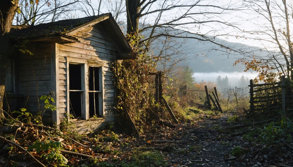
Fox Hollow: Remnants of an Extended Family Settlement
This Agricultural Legacy endured through four generations until 1941, when park creation forced their departure.
You’ll find remnants of their labor scattered throughout: rock walls, farm fences, and a seven-room log house foundation.
The family cemetery, where Lemuel rests, features quality headstones that challenge stereotypes of impoverished mountain dwellers, revealing the prosperity some hollow families achieved.
Rock piles along the trails stand as incidental memorials to the Fox family’s farming efforts in this once-cultivated landscape.
Nicholson and Weakley Hollows: Vanished Farmstead Communities
Among the earliest European settlements in what would become Shenandoah National Park, Nicholson and Weakley Hollows trace their origins to the 1770s and 1790s, when pioneer farmers claimed fertile bottomlands along the Hughes River and the long valley separating Old Rag Mountain from the main Blue Ridge.
Nicholson History reveals prosperous agricultural operations with terraced slopes and significant surpluses that funded consumer purchases rather than mere subsistence. The architectural landscape included diverse structures from farmhouses to slave quarters, reflecting the complex social fabric of these mountain communities.
The Weakley Economy proved even more diversified, supporting commercial sawmills, gristmills, legal distilleries, two stores, churches, and a post office serving roughly 460 residents across three hollows.
When park creation forced condemnation in the late 1920s–1930s, CCC crews razed most structures. Mid-1990s archaeological surveys uncovered mail order toys, china plates, and automobile parts, contradicting portrayals of isolated mountain poverty.
Today you’ll find only stone foundations, chimney falls, and fence lines haunting the trails.
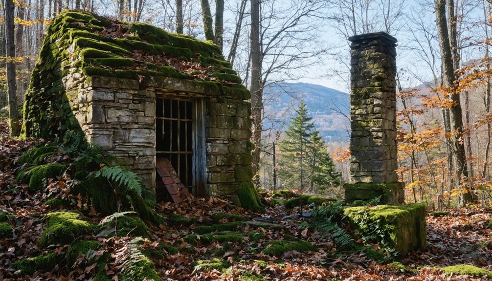
Pocosin Mission and Its Abandoned Cemetery
You’ll find the Episcopal Pocosin Mission ruins along Skyline Drive’s Pocosin Mission Trail, where stone foundations, collapsed chimneys, and a leaning log mission house mark Rev. Frederick W. Neve‘s 1904 effort to bring religious and educational services to isolated Blue Ridge families.
The complex served dual functions as both schoolhouse and church, distributing food and clothing to impoverished mountain residents who initially resisted outside intervention with documented violence before gradual acceptance.
Adjacent to these ruins lies an overgrown cemetery enclosed by deteriorating stone walls, holding unmarked graves of local families whose livelihoods centered on moonshining, bark peeling, and subsistence farming in what they called Upper Pocosin. The mission operated for approximately 20 years after the Towles sisters departed, serving as a vital connection between mountain communities and the outside world. The old cabins and structures along the trail are maintained by the Potomac Appalachian Trail Club, preserving these remnants of mountain settlement history.
Episcopal Mission’s Brief History
Between 1902 and 1904, Reverend Frederick W. Neve established the Episcopal Pocosin Mission atop Pocosan Hollow, part of his ambitious campaign to plant churches every ten miles across Virginia’s Blue Ridge.
The English-born minister recruited missionaries Florence and Edgar Towles to operate Far Pocosan—a simple building serving as both schoolhouse and chapel.
You’ll find the mission’s impact extended beyond Sunday worship; it distributed clothing, food, and basic supplies to isolated mountain families while educating their children.
Though initially met with wariness, the mission achieved genuine community transformation as locals integrated it into their social fabric.
Female mission workers’ diaries reveal evolving perspectives—from pity to admiration for mountain residents’ resilience.
The mission complex included a stone chapel and mission worker’s home, with remnants still visible at the site today.
The mission operated for roughly two decades after its founders departed, demonstrating lasting acceptance before park creation displaced these tight-knit communities.
The Lower Pocosan Mission remained outside park boundaries, while the Upper Pocosan site was acquired for Shenandoah National Park.
Cemetery and Cabin Remains
Today the mission’s legacy survives in scattered stone foundations and a haunting cemetery across the fire road from the main ruins.
You’ll find nameless fieldstones marking graves in a small cluster, their inscriptions erased by a century of moss and weather. The cemetery preservation challenge is formidable—leaf litter and brambles obscure the burial ground’s boundaries, which lack any intact fencing.
Nearby, a dilapidated wooden barn leans precariously, illustrating the difficulty of cabin restoration in backcountry conditions. One exception stands: a former dwelling now maintained and rented by the Potomac Appalachian Trail Club, representing rare survival amid wholesale abandonment.
Stone steps, collapsed chimneys, and cellar holes dot the overgrown crossroads, silent testimony to the displaced mountain community that once thrived here.
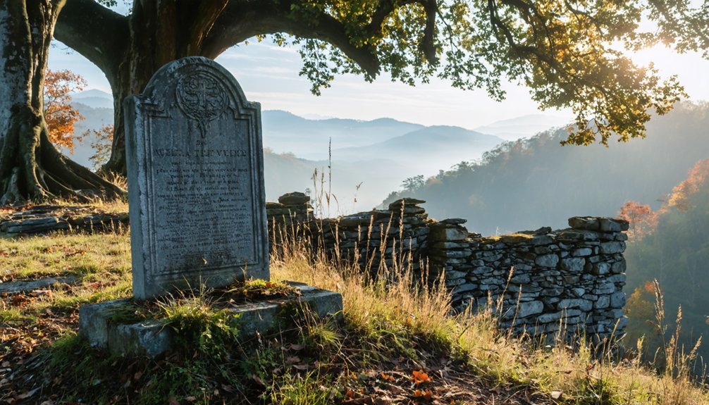
Over 100 Cemeteries Mark Former Mountain Settlements
When the federal government exercised eminent domain in 1935 to create Shenandoah National Park, over 450 families lost their ancestral lands, homes, and burial grounds in a mass displacement that reshaped the Blue Ridge Mountains.
Today, approximately 100 documented cemeteries remain scattered throughout park boundaries, marking where communities once flourished before forced removal.
These scattered burial grounds stand as silent witnesses to the communities displaced when the federal government seized these mountains.
These burial grounds hold tremendous historical significance as physical evidence of vanished settlements. Dean Cemetery near Skyline Drive contains graves spanning early settlements through recent decades, actively maintained by descendants rather than authorities.
Fox Cemetery preserves generations of family burials, though weathering has rendered most early 1900s gravestones illegible.
Cemetery preservation efforts continue despite natural deterioration—periwinkle vines and ornamental flowers planted by original families still bloom among fieldstones, defying government attempts to erase mountain heritage.
Browntown and Old Industrial Sites Along the Park Boundary
Tucked into the Gooney Run valley at the southern edge of Shenandoah National Park‘s boundary, Browntown stands as one of the few settlements that survived the federal land consolidation of the 1930s.
This mill village coalesced around the Brown–Updike Mill in the early 1800s, serving dispersed mountain farmers whose upper slopes were later absorbed into the park. You’ll find its linear roadside layout still intact, with 19th-century dwellings and a general store clustering near the stream crossing.
The settlement traces back to 1770, when Lord Fairfax leased manor tracts requiring stone chimneys and 100 fruit trees—evidence of permanent investment.
A 1996 flood nearly erased Browntown when Mt. Washington’s runoff surged through feeder creeks, destroying bridges and stranding residents for days along this isolated park fringe.
Visiting Shenandoah’s Ghost Settlements Today
Exploring Shenandoah’s abandoned settlements requires traversing fire roads and unmarked trails that branch from Skyline Drive into valleys where nature’s reclaimed what families left behind in the 1930s.
You’ll find Pocosin Mission’s concrete steps and collapsed chimney 2.5 miles along its namesake trail, while Fox Hollow Graveyard sits 1.5 miles through dense forest overgrowth.
Dean Cemetery remains accessible off Skyline Drive, displaying centuries of community storytelling through hand-carved headstones alongside recent markers.
The National Park Service’s 1989 archaeological surveys documented Confederate burial sites and French and Indian War graves, advancing historical preservation efforts.
Seasonal accessibility varies considerably—heavy rainfall transforms trails into muddy obstacles.
Select Potomac Appalachian Trail Club cabins along Pocosin Mission Fire Road offer overnight stays within these ghost settlements’ boundaries.
Visiting ghost towns near Grand Canyon Park provides a unique glimpse into the past, showcasing remnants of lives once lived in these secluded areas. Many of these towns have captivating histories that attract adventurous travelers and history enthusiasts alike. Exploring the haunted streets and abandoned buildings can be a thrilling experience, especially for those seeking the eerie beauty of forgotten places.
Frequently Asked Questions
Can Descendants of Displaced Families Visit Ancestral Homesites Within the Park?
Yes, you can visit your ancestral homesites within Shenandoah National Park. Park policies don’t restrict descendants from accessing publicly available areas. Your family connections to these lands require no special documentation, and rangers provide historical context upon request.
Are Any Original Structures From the Hollows Still Standing Today?
Few foundations, fireplaces, and fragmentary features remain; you’ll find mainly ruins lacking historic preservation or architectural significance. The 2006 wildfires and decades of park policy deliberately destroyed most original hollow structures, leaving only archaeological traces.
What Compensation Did Families Receive When Forced to Leave Their Land?
During Shenandoah’s land acquisition, you’d have received roughly $13 per acre in historical compensation—but only if you held legal title. Tenant farmers and squatters got nothing, creating stark inequalities among displaced families.
How Do I Locate a Specific Ancestor’s Grave in the Park?
Don’t put all your eggs in one basket—combine ancestor tracking through NPS cemetery surveys, Find a Grave indexes, and trail-based grave searching near documented homesites, while respecting park regulations protecting these irreplaceable cultural resources.
Were Any Residents Allowed to Remain After Park Establishment?
Yes, you’ll find that after park establishment, certain historical residents received life-estate arrangements or use-and-occupancy reservations, allowing mostly elderly landowners to remain in their homes until death, though hundreds were displaced.
References
- https://www.wabashtrace.org/trail-history-ghost-towns
- https://en.wikipedia.org/wiki/Shenandoah_Woods
- https://apalacheresearch.com/2021/07/28/ghosts-soul-mates-and-demons-on-the-tipton-thornton-farm-in-the-shenandoah-valley/
- https://middlejourney.com/cemeteries-in-shenandoah-national-park/
- https://www.shenandoahliterary.org/731/open-spaces/
- https://www.nps.gov/subjects/abandonedplaces/visit.htm
- https://www.youtube.com/watch?v=0CXelQkr1H8
- https://www.nps.gov/shen/learn/historyculture/displaced.htm
- https://www.nps.gov/articles/mountain-settlements.htm
- https://www.abandonedcountry.com/2013/12/23/a-keeper-of-shenandoah-national-parks-forgotten-memories-2/


