You’ll find five authentic ghost towns within an hour of St. George, each preserving unique frontier heritage. Silver Reef showcases 1870s mining architecture along its mile-long Main Street, while Harrisburg’s stone cottages from the 1860s Cotton Mission still stand near Quail Creek. Grafton, Utah’s most photographed ghost town, features its 1886 adobe schoolhouse beside the Virgin River. Old Iron Town displays beehive charcoal kilns from Brigham Young’s Iron Mission, and remnants of Atkinville mark vanished agricultural settlements. The sections below detail visiting logistics, preservation efforts, and historical context for each site.
Key Takeaways
- Silver Reef, 20–25 minutes from St. George, was Utah’s major silver boomtown with over 400 mine openings yielding $8 million.
- Grafton, 45–60 minutes away, is the most photographed ghost town featuring an 1886 schoolhouse and pioneer cemetery along Virgin River.
- Harrisburg offers preserved stone ruins including the restored Orson B. Adams House, located just 15–20 minutes from St. George.
- Old Iron Town, one hour 15 minutes away, showcases beehive charcoal kilns from 1868 ironworks operations on the National Historic Registry.
- Best visiting times are spring and fall; summer requires early-morning visits while winter snow may restrict higher-elevation access.
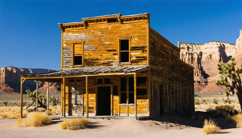
Silver Reef: Utah’s Unlikely Silver Mining Boomtown
Sandstone reefs west of St. George concealed Utah’s most improbable fortune: silver locked in white stone ridges where conventional geology said it couldn’t exist.
When John Kemple discovered ore in 1866, skeptics dismissed his find. By 1875, renewed interest transformed White Reef into a thriving camp of 2,000 souls—miners who’d abandoned Pioche’s fading prospects for this anomaly.
Over 400 mine openings honeycomb the district, yielding $8 million in silver by 1891. Main Street stretched a full mile, lined with saloons, banks, and Wells Fargo’s office.
Four hundred tunnels carved wealth from impossible stone—a mile-long monument to defiant fortune hunters who rejected geological limits.
Falling prices and flooded shafts ended the boom by 1884. The Silver Reef Consolidated Mining Company briefly resumed operations in 1916, acquired by American Smelting and Refining Company twelve years later before the Great Depression halted development. Uranium mining commenced in 1951, bringing new prospectors to the played-out silver camp. Today’s ghost town preserves this silver mining rebellion against geological doctrine—proof that freedom-seekers prospect where experts won’t.
Harrisburg: Stone Ruins Along Quail Creek
Just sixteen miles northeast of St. George along Quail Creek, you’ll find Harrisburg’s scattered stone ruins—remnants of a Mormon settlement founded around 1859–1861 that struggled against floods, drought, and unforgiving soil.
The town’s defining feature was its near-universal use of stone architecture, with skilled mason Willard G. McMullin crafting cottages and houses that still stand in partial form on both sides of Interstate 15.
Today you can trace the community’s arc from hopeful permanence to abandonment through surviving foundations, wall fragments, and the restored Orson B. Adams House perched above the ghost town site. The settlement was officially abandoned and became a ghost town by 1895 after enduring decades of environmental hardships. Access to the historic site requires permission from the RV Camp that now occupies the eastern portion of the old town.
Settlement History and Decline
Nestled along Quail Creek approximately 16 miles northeast of St. George, Harrisburg was established by Moses Harris and Mormon families between 1859–1861 as part of the Cotton Mission expansion.
You’ll find this settlement faced pioneering challenges from the start—the original townsite flooded in 1862, forcing residents uphill. Agricultural struggles intensified as the community of roughly 200 souls by 1868 battled limited fertile soil and unreliable water flows.
The collapse came swiftly: a devastating grasshopper plague in 1869 destroyed crops, followed by Navajo raids and persistent drought. Like its Pennsylvania namesake founded by John Harris, Jr., this western Harrisburg bore the Harris family legacy in a far harsher landscape. Residents abandoned their hard-won homesteads for opportunities in nearby Silver Reef and Leeds.
By 1969, the town’s transformation into a ghost town was complete, with most residents having departed due to the accumulated harsh conditions that made permanent settlement untenable.
Stone Structures and Ruins
Today, the most tangible remnants of Harrisburg’s brief existence stand in stone—walls, foundations, and skeletal frames scattered along Quail Creek’s banks where Mormon pioneers once cultivated their doomed farms.
Stone mason Willard G. McMullin constructed numerous cottages between 1862 and 1865, their durability outlasting wooden structures by generations.
You’ll find these architectural preservation efforts straddling Interstate 15:
- East Side Ruins: Multiple crumbling houses accessible through RV Camp property
- Adams House: Fully restored stone mansion towering over McMullin’s original property
- Reinforced Structure: Wooden frames inserted into window openings prevent total collapse
The stone masonry’s quality enabled natural preservation across 160 years.
Red rock mountains surround these skeletal testimonies to settlement ambition, standing defiant against erosion and time’s relentless march.
The original settlement, founded in 1859, bore the name Harrisville after Moses Harris who established the town before residents were forced to relocate up the creek.
The community’s population swelled to 200 by 1868, marking its peak before a series of devastating hardships led to its eventual abandonment.
Visiting the Site Today
Sixteen miles northeast of St. George along I-15, you’ll find Harrisburg’s ruins split by the interstate—remnants on both sides invite self-guided exploration.
The Harrisburg exit leads directly to an RV park and scattered foundations near Quail Creek, with the cemetery offering prime photography opportunities. Year-round access makes this ghost town an easy day-trip stop between St. George and Zion, often paired with Silver Reef or Leeds visits.
Visitor tips: prepare for arid desert heat, bring water, and respect the mix of private RV-park land and protected Red Cliffs National Conservation Area holdings.
Interpretive plaques guide your wandering through 19th-century settlement patterns. Watch for local wildlife adapted to this biologically diverse terrain, framed by Pine Valley Mountains rising to 10,371 feet at Signal Peak. The nearby Quail Creek Reservoir draws water from Cottonwood Creek, the waterway that gave Harrisburg its original name.
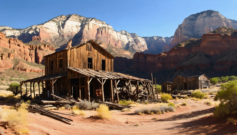
Old Iron Town: Charcoal Kilns and Industrial Heritage
Twenty-four miles west of Cedar City, the skeletal remains of Old Iron Town mark one of Utah’s most ambitious—and short-lived—frontier industrial experiments. Founded in 1868 as part of Brigham Young’s “Iron Mission,” this settlement supported the Great Western Iron Company’s blast furnace operations until economic collapse forced closure in 1876.
The preserved beehive kiln stands as evidence to charcoal production methods that fueled frontier smelting. Workers stacked juniper and pinyon pine inside these chambers, creating controlled, low-oxygen smoldering conditions that maximized carbonization.
Industrial technology at peak operation included:
- Blast furnace producing 5–7 tons of pig iron daily
- Multiple charcoal kilns feeding foundry operations
- Erastra grinding device for sand preparation
You’ll find foundation ruins, chimney segments, and interpretive markers documenting this 1870s operation that once employed hundreds before cheaper eastern iron rendered it obsolete. The site holds designation as a National Registry of Historic Places, recognizing its significance to Utah’s early industrial development.
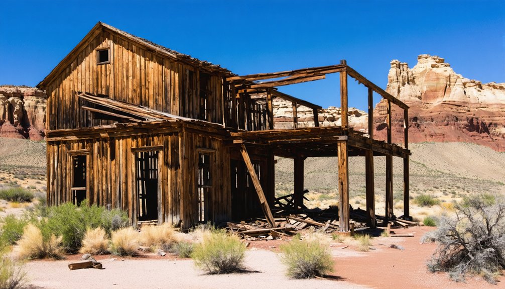
Grafton: The Virgin River’s Most Photogenic Ghost Town
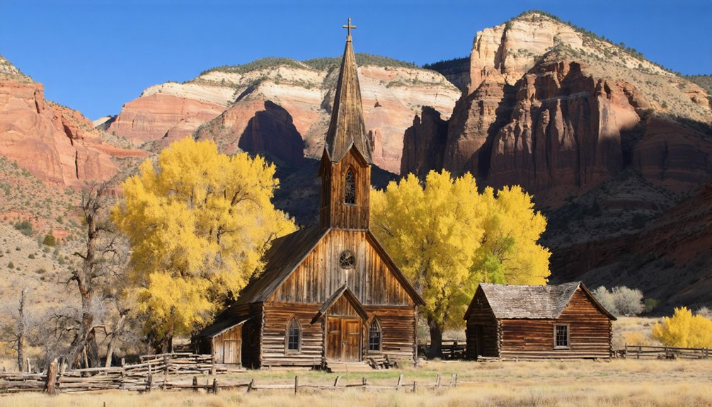
You’ll find Grafton tucked along the Virgin River just outside Springdale, where its 1886 adobe schoolhouse and weathered frame homes have earned it recognition as the most photographed ghost town in the American West.
The settlement’s history reads like a chronicle of pioneer endurance: founded in 1859, destroyed by the catastrophic 1862 flood, rebuilt a mile upstream, then gradually abandoned as repeated floods and the 1906 Hurricane Canal diverted both water and families away from the vulnerable townsite.
Today the preserved buildings and hillside cemetery—where headstones mark victims of floods, conflict, and frontier hardship—offer you tangible evidence of why this Virgin River community became a ghost town twice, first in 1866 and permanently by 1944.
Historic Buildings and Cemetery
Grafton’s reputation as one of the most photographed ghost towns in the American West rests largely on its collection of intact historic buildings framed against the Virgin River’s red-rock canyon.
The Grafton architecture showcases the settlement’s evolution from frontier outpost to established Mormon agricultural village.
Key structures you’ll encounter include:
- 1886 Adobe Schoolhouse – Two-story building with distinctive wooden belfry that served as school, church, and community center
- Pioneer Residences – Brick and wood-frame homes on one-acre lots, stabilized to preserve their weathered character
- Grafton Cemetery (1862–1924) – Burial ground on a small rise featuring simple cemetery markers and carved headstones
The Heritage Partnership Project maintains these sites without heavy reconstruction, letting you experience authentic frontier remnants on your own terms.
Flooding and Abandonment History
Unlike most pioneer settlements that faded gradually, Grafton faced catastrophic erasure almost from the start. The January 1862 Great Flood destroyed the original Wheeler settlement, sending houses and molasses barrels downriver.
You’ll find this flood damage extended beyond Grafton, devastating Adventure, Northup, and Duncans Retreat.
Survivors rebuilt one mile upstream, renaming it New Grafton, but the Virgin River’s temperament hadn’t changed. Irrigation dams washed out multiple times yearly, while heavy silt clogged ditches weekly—creating relentless agricultural challenges.
The 1866 Black Hawk War forced complete evacuation to Rockville, with farmers risking daily returns to tend flood-damaged fields.
Though resettled by 1868, continued flooding erased precious farmland. Without new acreage for younger families, Grafton’s population dwindled toward inevitable abandonment.
Atkinville and Price City: Forgotten Farming Settlements
Today’s remnants tell the story:
- Rock walls and foundations from two homes mark original construction
- Irrigation infrastructure shaped by now-vanished water sources
- SunRiver community occupies former farmland, erasing ghost-town status
Like nearby Price City history, Atkinville represents Washington County’s agricultural settlements that couldn’t sustain independence—victims of depopulation before modern development reclaimed the land entirely.
Best Times to Visit Southern Utah Ghost Towns
Timing your ghost town exploration around southern Utah’s extreme seasonal swings separates rewarding discovery from heat-stressed endurance.
With the right timing, you can explore abandoned sites near Hurricane Utah, uncovering remnants of the past that tell fascinating stories. Each site offers a unique glimpse into the lives once lived there, surrounded by stunning desert landscapes. Make sure to carry plenty of water and a camera to capture the beauty of these forgotten places.
Spring (March–May) and fall (September–October) deliver mild temperatures and longer daylight, making them the best visiting times for sites like Grafton and Silver Reef.
Summer’s 100°F-plus heat demands early-morning or sunset schedules—golden hour light transforms weathered wood and brick into vivid photography subjects while reducing dehydration risk.
Winter opens higher-elevation locations near Cedar City to snow-dusted ruins, though unpaved roads may turn impassable.
Shoulder seasons cut Zion spillover crowds at Grafton; midweek visits guarantee solitude.
Carry ample water year-round—shade vanishes among exposed foundations.
Evening explorations reward you with cooler air, dramatic red-rock color, and star-filled skies, honoring both safety and photography tips that capture these abandoned settlements authentically.
Driving Distances and Access Routes From St. George
Because St. George sits near I-15 and UT-9, you’ll find straightforward route navigation to four distinct ghost towns:
- Silver Reef (20–25 min): Take I-15 north to Exit 22, then west on Silver Reef Road—paved access, 2WD suitable.
- Harrisburg (15–20 min): Exit I-15 between Leeds and Quail Creek; note the narrow underpass and permission requirements for some ruins.
- Grafton (45–60 min): Follow UT-9 east to Rockville, cross the bridge south—graded dirt sections demand higher clearance in wet conditions.
- Old Iron Town (1 hr 15 min): I-15 north to Cedar City, then UT-56 west; chip-seal finale slows progress.
Weather directly affects driving conditions on unpaved stretches.
You’ll navigate freeway corridors, rural highways, and historic byways—each route preserving access to Utah’s mining and settlement legacy.
Combining Ghost Town Exploration With Zion National Park
Once you’ve mapped your driving routes to these historic sites, you’ll discover that Grafton Ghost Town creates the most natural pairing with any Zion National Park visit.
Located along the Virgin River just south of the park boundary, Grafton’s five standing adobe structures frame Zion’s red cliffs in compositions that reward ghost town photography enthusiasts.
Grafton’s adobe ruins and red cliff backdrops create picture-perfect compositions that elevate any photographer’s Zion adventure.
You’ll trace the same pioneer challenges visible in Zion’s canyon hydrology through Grafton’s cemetery and flood-abandoned farmsteads.
Silver Reef and Old Iron Town add mining history perspectives, contrasting industrial boom-and-bust cycles with Zion’s agricultural valleys.
Half-day Zion hikes blend seamlessly with self-guided walks through Grafton’s orchard-dotted grounds, while golden-hour light over Virgin River bottomlands extends your photography day beyond the park’s crowded overlooks.
Frequently Asked Questions
Are Any Ghost Towns Near St. George on Private Property?
Yes, several ghost towns near St. George sit on private property. Silver Reef’s townsite and Shonesburg’s rock home have private ownership restricting legal access. You’ll need permission before exploring, as trespassing laws fully apply despite abandonment.
Can You Camp Overnight at Ghost Town Sites Near St. George?
Overnight camping at ghost-town ruins themselves is typically prohibited; camping regulations steer you toward nearby BLM dispersed sites or formal campgrounds with campsite amenities, protecting fragile structures while preserving your backcountry access.
Do I Need a Four-Wheel-Drive Vehicle to Reach These Ghost Towns?
Not for the easiest sites—ironically, ghost town accessibility near St. George spans interstate-adjacent ruins to backroad adventures. Vehicle recommendations vary: Harrisburg and Silver Reef need only 2WD; Grafton’s dirt track rewards higher clearance and four-wheel-drive capability.
Are Ghost Town Sites Near St. George Safe for Children?
Ghost town safety varies widely; supervised child exploration works best at managed sites like Grafton and Silver Reef, where you’ll find clearer paths and structures, while remote ruins demand careful attention to unstable walls and desert hazards.
What Should I Bring When Visiting Ghost Towns in the Desert?
Bring essential supplies: 3–4 liters of water, sun protection, sturdy footwear, offline maps, and first-aid supplies. Pack camera equipment to document historic structures, plus snacks, electrolytes, and emergency gear for remote desert exploration.
References
- https://en.wikipedia.org/wiki/List_of_ghost_towns_in_Utah
- https://www.visitutah.com/things-to-do/history-culture/ghost-towns
- https://saltlakeexpress.com/7-utah-ghost-towns-close-15/
- https://www.youtube.com/watch?v=AoiIha-3iNo
- https://abbeyinncedar.com/1896/
- https://www.sgutah.com/southern-utah-ghost-towns.php
- https://westernmininghistory.com/towns/utah/silver-reef/
- https://en.wikipedia.org/wiki/Silver_Reef
- https://www.youtube.com/watch?v=IwI2R7TMWLA
- https://greaterzion.com/a-history-of-the-establishment-of-silver-reef-utah/


