You’ll find three well-preserved ghost towns within a thirty-mile radius of Stanley, Idaho, each telling distinct chapters of 1870s mining history. Custer sits just two miles north of Bonanza along the Yankee Fork, both accessible via Highway 75, while Bayhorse’s silver-lead ruins lie south near Challis. These settlements—abandoned between 1910 and 1915—feature original storefronts, stamp mill foundations, and beehive charcoal kilns that whisper tales of boom-and-bust economies. The complete story of these mining communities reveals fascinating details about their unique characteristics and ideal visiting conditions.
Key Takeaways
- Custer Ghost Town, two miles north of Bonanza, was founded in 1879 and features Idaho’s most intact ghost town streetscape.
- Bonanza Ghost Town, established in 1877, served as a service hub with unique amenities like dentists and watchmakers for mining communities.
- Bayhorse Ghost Town offers silver-lead mining ruins including stamp mill foundations and beehive charcoal kilns from the 1880s.
- Access is via Highway 75 on the Salmon River Scenic Byway with nine miles of graded gravel roads.
- Best visiting period is Memorial Day through Labor Day when museums operate and road conditions are most favorable.
Custer Ghost Town: Stanley’s Closest Historic Mining Settlement
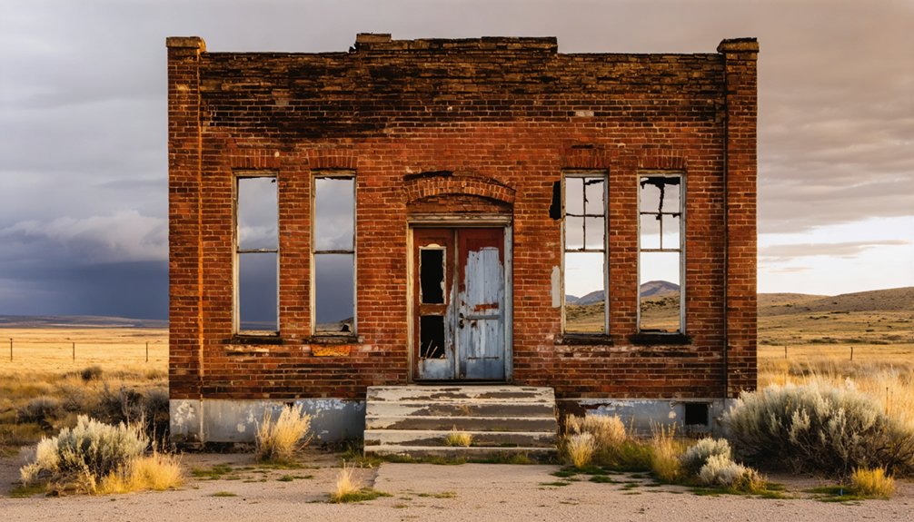
Just two miles north of the vanished settlement of Bonanza, Custer Ghost Town stands as the most accessible historic mining camp from Stanley, its weathered buildings clustered below where the General Custer mill once processed ore from the Yankee Fork River valley.
Founded in 1879 by gold speculators including Harvard-educated Sam Holman, this settlement’s Custer history reflects the boom-and-bust cycle that defined Idaho’s mining frontier.
You’ll discover how mining techniques evolved here from 1876’s initial placer operations to the sophisticated mill completed in December 1880, which extracted gold, silver, copper, and lead from the Lucky Boy and Black mines.
The town peaked at 600 residents in 1896 before exhausted veins triggered abandonment by 1910, leaving behind authentic structures you can explore freely today.
Walk through the Empire Saloon, once the social hub where miners gathered, now offering historical souvenirs to visitors.
When visiting, bring water and snacks to stay energized as you wander through the historic remnants and photograph the scenic mountain landscapes surrounding this preserved mining settlement.
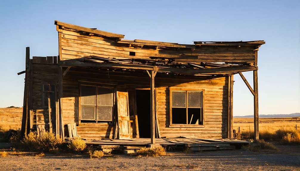
Bonanza Ghost Town: Sister City on the Yankee Fork
Established in 1877 by Charles Franklin two years before Custer took shape, Bonanza earned distinction as the Yankee Fork’s first substantial mining camp, its tree-lined streets and log buildings spreading across a valley eight miles upstream from the Salmon River.
Bonanza history reveals a population of 600 by 1881, supported by hotels, saloons, a newspaper, and recreation facilities including croquet fields and a race track.
Unlike Custer’s mill-driven economy, Bonanza thrived as a service hub for scattered claims. The town also featured a dentist and watchmaker, offering specialized services uncommon in many mining settlements. An underground water system provided both drinking water and fire protection to the growing community. Yet devastating fires in 1889 and 1897 destroyed much of the business district, sending residents relocating to Custer.
Bayhorse Ghost Town: Silver and Lead Mining Ruins South of Challis
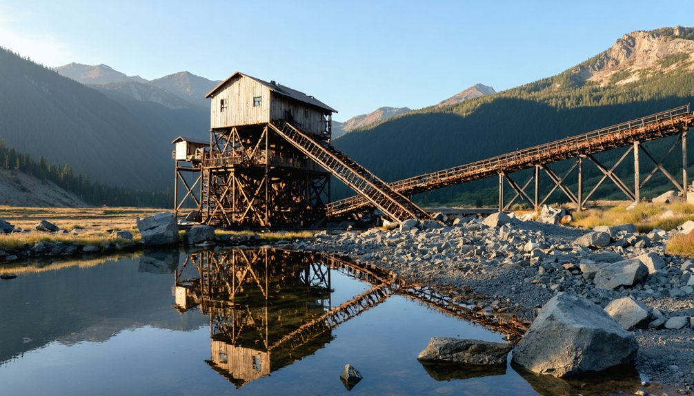
You’ll find Bayhorse’s industrial legacy preserved in its scattered ruins along Bayhorse Creek, where the Gilmer & Salisbury stamp mill foundations and a row of exceptional stone charcoal kilns stand as testimony to the district’s ambitious silver-lead operations of the 1880s.
The site, listed on the National Register of Historic Places since 1976, offers tangible connections to central Idaho’s hard-rock mining heritage through weathered structures, machinery remnants, and the austere canyon setting that once housed 300–500 residents.
Today’s visitors can explore these ruins and imagine the freight wagons that hauled $800-per-ton ore shipments out of this remote canyon to distant smelters.
The Bureau of Land Management manages the site year-round, providing historical information to visitors while monitoring preservation efforts to protect the town’s historic value.
A devastating fire in 1889 destroyed many of Bayhorse’s original structures, reshaping the town’s physical landscape during its active mining years.
Historic Mining Infrastructure Remains
Seventeen miles south of Challis, the Bayhorse mining district spreads across a steep canyon where silver-lead operations once generated an estimated $10 million by 1898.
You’ll find historic mining infrastructure scattered along the slopes—gravity-fed stamp mill foundations clinging to canyon walls, smelter ruins from the 1880s expansion, and iconic beehive charcoal kilns standing sentinel on the outskirts.
These industrial relics tell the story of hard-rock mining that began in 1877, when multiple adits and drifts penetrated the mountainside to extract ore.
The mill processed material through a multi-story descent, while 48 workers fired kilns producing 80,000 bushels of charcoal annually until coke replaced it in 1885.
Ore bins and tram foundations remain visible where gravity systems once hauled silver-lead concentrates downward for smelting and eventual shipment as bullion.
The town’s prosperity ended when the Ramshorn Mine ceased production in 1888, triggering a gradual exodus that left Bayhorse abandoned by 1915.
Guided tours are available today as part of ongoing preservation efforts to maintain the site’s historical structures and educate visitors about the mining district’s significance.
Access and Visitor Activities
Located seven miles southeast of Challis within the Land of the Yankee Fork State Park, Bayhorse Ghost Town welcomes visitors via a four-mile gravel access road that branches from Highway 75.
You’ll pay $5–$7 at the self-service station, then park in the paved lot near clean vault toilets.
Ghost town exploration follows a 0.9-mile loop trail connecting mining-era structures, with interpretive signage preserving the stories of 1870s prospectors who extracted silver and lead from these remote mountains.
Visitor safety protocols restrict motorized travel within the townsite itself—you’ll walk among the weathered buildings and examine machinery from outside designated boundaries.
Beyond the historic core, hundreds of miles of OHV trails thread through Salmon-Challis National Forest, letting you ride motorbikes and ATVs along routes those original miners blazed.
The site features several well-preserved charcoal kilns that stand as remarkable examples of 19th-century mining infrastructure.
At an elevation of 6,125 feet, Bayhorse offers expansive views of the surrounding Stanley/Challis mountain range.
Land of the Yankee Fork State Park: Gateway to Mining History
Before you venture out to Custer, Bonanza, or Bayhorse, you’ll want to stop at the Land of the Yankee Fork Interpretive Center near Challis—the official gateway that opened in 1992 to orient visitors to Idaho’s frontier mining heritage.
Inside, museum exhibits, artifacts, and a hands-on gold-panning station bring the late-19th-century rushes to life and help you plan your route through the scattered ghost towns.
The center also coordinates guided tours of the nearby Yankee Fork Gold Dredge, a towering relic of industrial-scale mining that reshaped miles of river gravels between the 1940s and 1952.
Interpretive Center & Tours
Two miles south of Challis, where US-93 meets ID-75, the Land of the Yankee Fork Interpretive Center stands as your essential gateway to understanding the ghost towns scattered throughout this rugged mining district.
Inside, interpretive exhibits showcase mining tools, domestic artifacts, and equipment from Custer, Bonanza, and Bayhorse—concentrating the scattered history into one accessible location before you venture into backcountry terrain.
The center serves as command central for your 98-mile loop drive through Idaho’s frontier mining landscape. You’ll find detailed maps, route guidance for Custer Motorway’s challenging grades, and trip-planning resources that maximize your autonomy on these remote roads.
Try gold panning demonstrations, watch orientation films, then strike out independently—armed with knowledge that transforms crumbling cabins and dredge tailings into tangible stories of self-reliant prospectors who carved communities from wilderness.
Yankee Fork Gold Dredge
Twenty-two miles from Stanley, the Yankee Fork Gold Dredge rests motionless in its self-created pond—a 988-ton monument to mid-century industrial ambition frozen precisely where J.R. Simplot abandoned it in 1952.
Built in just five months during 1940, this Bucyrus-Erie bucket-line dredge represents the pinnacle of placer dredge technology, capable of processing 5½ miles of valley floor.
You’ll witness the mining legacy that extracted millions in gold while operating 24/7, its Byron-Jackson pumps silent now.
The machinery displaced Indigenous communities and devastated salmon runs—consequences that sparked Idaho’s 1954 Dredge Act.
Today’s restoration efforts attempt reversing decades of habitat destruction, though the towering tailing piles remain as evidence of an era when profit preceded preservation.
The Yankee Fork Gold Dredge: Industrial Mining Preserved
The Yankee Fork Gold Dredge stands today as Idaho’s largest self-powered gold dredge, a 988-ton industrial relic measuring 112 feet long, 54 feet wide, and 64 feet high.
Built in 1940 by Bucyrus-Erie, this bucket-line dredge technology processed gravels along a 5½-mile claim, extracting an estimated $11 million in gold.
You’ll see how it operated continuously—24 hours daily—using 8-cubic-foot buckets and Byron-Jackson pumps to wash placer deposits through trommels and sluices.
The environmental impact is unmistakable: parallel “corn-row” tailings stretch for miles, reshaping the valley floor and devastating Chinook salmon habitat.
The dredge’s legacy remains visible in miles of gravel tailings that transformed the valley and destroyed vital salmon spawning grounds.
After shutdowns during World War II and ownership changes—including purchase by J.R. Simplot for $75,000 in 1949—operations ceased in 1952.
Today it’s preserved as a monument to an era when gold mattered more than rivers.
Getting There: Routes and Road Conditions From Stanley
From Stanley, you’ll follow Idaho State Highway 75 northeast along the Salmon River Scenic Byway, a paved two-lane mountain road that climbs and curves through river canyons for roughly 58 miles before reaching the Yankee Fork turnoff near the historic Sunbeam Dam site.
What to expect on your journey:
- Nine miles of side road—partly paved, finishing as graded gravel—separate you from Custer and Bonanza’s weathered storefronts.
- Standard sedans navigate dry-season conditions without difficulty, though road safety demands reduced speeds over washboards and embedded rocks.
- Seasonal conditions shift dramatically: summer dust gives way to spring mud and winter ice advisories.
- Wide pullouts offer freedom to pause, turn around, or let faster travelers pass.
Check Idaho Transportation Department reports before departure, especially during shoulder seasons when weather transforms accessible routes into challenging backcountry drives.
Best Times to Visit the Ghost Town Corridor
Timing shapes every aspect of your ghost town pilgrimage, and nowhere does the calendar wield more influence than along the Yankee Fork corridor, where mountain weather dictates which weathered storefronts you’ll reach and which remain locked behind seasonal gates.
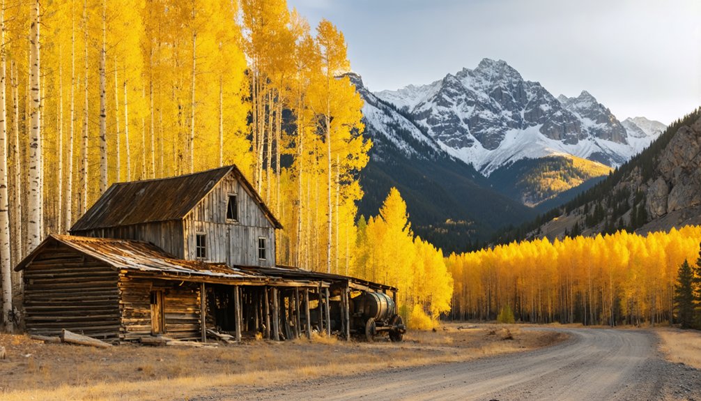
Memorial Day through Labor Day guarantees open museums and passable gravel roads, though July–August crowds can dilute the solitude these ruins deserve. Shoulder season strategies favor late May and September, when aspens gild the valleys and you’ll photograph Bonanza’s collapsing facades without tourist intrusion.
Chase September’s golden aspens when silence returns to Bonanza’s abandoned streets and summer’s crowds have surrendered to shorter days.
Most services close after Labor Day, so verify hours beforehand. Winter seals the corridor entirely—unplowed roads and subzero temperatures make visits impractical without snowmobiles.
For visitor tips prioritizing freedom: arrive mid-week in June or early September, when the land yields its stories to those willing to chase receding snow.
What to See: Buildings, Equipment, and Cemeteries
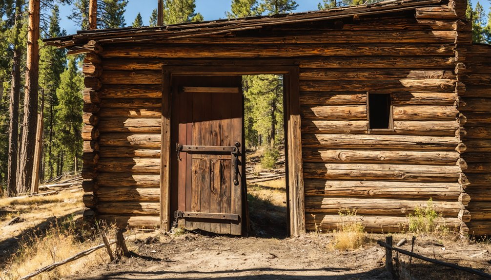
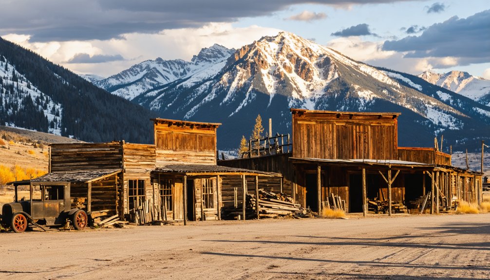
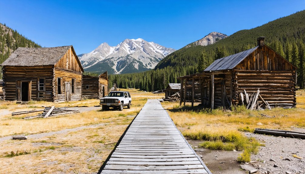
When you step onto Custer’s weathered boardwalks, you’ll encounter one of Idaho’s most intact ghost town streetscapes—a parade of false-front commercial buildings that have weathered thirteen decades with surprising dignity.
The abandoned architecture tells stories through original wood siding, furnished miners’ cabins, and the 1879 Masonic Lodge standing sentinel over the valley.
Beyond Custer, you’ll discover historical artifacts frozen in time:
- The Yankee Fork Gold Dredge—a hulking industrial monument to placer mining ambition
- Rusting ore carts and winches surrendering to grass in overgrown clearings
- Pioneer cemeteries where wooden markers chronicle mining accidents and frontier hardship
- Bayhorse’s stone ruins and charcoal kilns offering rawer, less-curated exploration
Each site preserves freedom’s price—the unvarnished record of those who chased fortune into Idaho’s remote mountains.
Planning Your Ghost Town Adventure: Tours and Self-Guided Exploration
Whether you prefer the structured narrative of guided interpretation or the solitary freedom of discovery at your own pace, reaching Idaho’s Yankee Fork ghost towns demands practical planning around access routes, seasonal windows, and the infrastructure supporting historical preservation.
Custer offers docent-led tours during summer months, enriching your historical research with context about mining life, while Bonanza welcomes self-guided wandering among weathered cabins ideal for ghost town photography.
Access via Highway 75 and Yankee Fork Road remains passable for standard vehicles June through September, though the Old Custer Motorway Adventure Road requires high-clearance capability.
The Land of the Yankee Fork Interpretive Center in Challis provides essential maps, exhibits, and trip-planning advice.
Independent explorers gain flexibility; guided visitors receive curated storytelling—both pathways honor these resilient communities.
Frequently Asked Questions
Are Pets Allowed at the Ghost Town Sites?
Like frontier companions following wagon trails west, you’ll find pet friendly policies welcome your four-legged explorers at Bonanza and Custer ghost towns, though leash requirements honor preservation of these historic mining camps’ fragile legacy.
Is There Cell Phone Coverage Near Custer and Bonanza?
You’ll find limited cell coverage near Custer and Bonanza ghost towns. CusterTel Wireless offers rural connectivity in this region, though you’re venturing into areas where signal strength diminishes. AT&T provides the strongest coverage countywide at 12.4%.
Can You Camp Overnight Near the Ghost Towns?
You can’t sleep among the historic structures themselves, but you’ll find freedom-friendly dispersed camping on surrounding forest land and nearby campgrounds along the Yankee Fork, respecting camping regulations protecting these nostalgic mining sites.
Are the Ghost Towns Wheelchair Accessible?
Custer offers partial wheelchair accessibility with restrooms and wheelchair ramps at main buildings, plus accessible trails on packed paths. Bonanza remains unrestored with rugged terrain, limiting mobility access to your vehicle’s immediate area.
Do I Need a High-Clearance Vehicle for the Roads?
Road conditions vary by route; you’ll need high-clearance for Custer Motorway from Challis, but vehicle recommendations allow standard cars on Yankee Fork Road from Sunbeam during dry summer weather—freedom awaits either way.
References
- http://archives.idgenweb.org/history-ghost+towns.html
- https://idaho-forged.com/idahos-ghost-towns-eerie-yet-approachable/
- https://discoversawtooth.org/love-history-must-see-sites-in-the-sawtooths
- https://visitidaho.org/travel-tips/explore-idahos-ghost-towns/
- https://www.youtube.com/watch?v=LIUEItjPFd4
- https://www.atlasobscura.com/places/custer-ghost-town
- https://www.islands.com/1748075/custer-ghost-town-wild-west-ghostly-charm-abandoned-idaho-timeless-beauty/
- https://visitidaho.org/things-to-do/ghost-towns-mining-history/custer-historic-mining-town/
- https://www.fs.usda.gov/r04/salmon-challis/recreation/custer-town-site-interpretive-site-major
- https://www.legendsofamerica.com/id-bonanzacuster/