You’ll discover several authentic ghost towns within 30 miles of Tehachapi, including Caliente, a preserved railroad town frozen since the 1950s when diesel replaced steam locomotives, and Bealville, now just depot foundations and ruins marking California Historical Landmark No. 741. The engineering marvel of Tehachapi Loop, built by 3,000 Chinese laborers between 1874-1876, still carries freight trains past these abandoned settlements. Silver City Ghost Town near Bodfish showcases relocated structures from mining camps like Claraville and Keyesville, while Garlock’s remnants recall the 1890s gold rush that created—and destroyed—entire communities virtually overnight.
Key Takeaways
- Caliente, established in 1860, is a preserved railroad town with historic water tanks and a mission-style depot one mile from Tehachapi.
- Bealville, located 1.25 miles south of Caliente, is a Historical Landmark waypoint connecting valley agriculture to Kern County mining districts.
- Silver City Ghost Town near Bodfish, 30 miles west, features relocated structures from Claraville, Whiskey Flat, and Keyesville mining camps.
- The Tehachapi Loop, built 1874-1876, is an engineering marvel carrying freight trains through the region’s historic settlement corridor.
- Garlock, a 1890s mining boom town, became a processing hub with 200 residents before rapidly collapsing when ore declined.
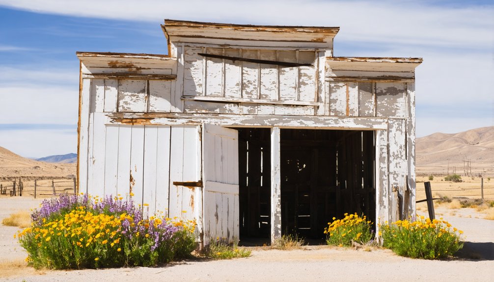
Caliente: A Railroad Boom Town Frozen in Time
By 1860, a small settlement had taken root at the junction of freight and stage routes serving Havilah, the Kern County seat perched in the mountains to the east.
When Southern Pacific’s tracks arrived in April 1875, the community became “Caliente”—named for nearby hot springs—and transformed into a crucial railhead.
You’ll find echoes of railroad history everywhere: two massive water tanks that once served steam locomotives, the telegraph station that coordinated train orders, and weathered frame cottages where 3,000 construction workers bunked while attacking Tehachapi Pass.
Today’s town preservation efforts keep this railroad heritage visible. The mission-style depot now houses city offices, a library, and the Civic Center, preserving the community’s architectural legacy.
Colonel Thomas Baker built a toll road connecting Bena and Caliente in 1867, establishing a critical transportation corridor years before the railroad arrived.
Diesel’s arrival in the late 1950s ended Caliente’s operational importance, freezing it mid-century—a living museum of Southern Pacific’s golden age.
Bealville: Gateway to Kern County’s Mining Past
Just 1.25 miles south of Caliente, you’ll find Bealville, a landmark community that once served as a critical waypoint between the San Joaquin Valley and the desert mining districts threading through Kern County’s lower Sierra foothills.
Named for Edward Fitzgerald Beale—the landowner, mining entrepreneur, and federal official who established his home here in 1855—the settlement anchored a transportation corridor that evolved from wagon road to transcontinental railroad to segments of Route 66.
Today, Bealville’s depot foundations and scattered ruins mark where ore shipments, livestock, and telegraph messages once flowed through a gateway that connected valley ranches to the region’s extractive economy. The Beeville Depot and Telegraph office was established in 1876, serving as a communication hub for the growing railroad community. Like many settlements in California’s mining districts, Bealville exemplifies the definition of a historic community, where remnants of the past remain visible among ongoing residential and commercial activity.
Historical Landmark Status
Recognized by the State of California as Historical Landmark No. 741, Bealville earned its official designation on July 5, 1960, when preservationists documented its significance as the home of Edward Fitzgerald Beale on Rancho El Libre beginning in 1855.
You’ll find the bronze plaque along Bealville Road, installed by the Kern County Historical Society on July 15, 1962, marking this foothill site at 1,811 feet elevation.
The landmark recognition doesn’t just commemorate Beale’s ranching—it explicitly acknowledges he “also engaged in mining,” anchoring Bealville’s role as a gateway between valley agriculture and Kern’s mineral-rich interior. Before establishing his homestead, Beale served under Commodore Stockton during the 1846 military campaigns that helped secure California for the United States. During the 1850s, Beale served as superintendent of California Indian Affairs, shaping federal policy toward indigenous populations throughout the region.
Historic preservation efforts here connect you to California’s broader program protecting sites where resource development, transportation networks, and frontier settlement converged during the state’s formative decades.
Mining Corridor Connection
Bealville’s 1855 founding placed Edward Fitzgerald Beale’s ranch headquarters at the threshold of Kern County’s mining boom, just four years after Antonio del Fierro Coronel discovered gold at Greenhorn Creek near the Kern River.
You’ll find this settlement served as a natural waypoint between Bakersfield and the mining districts scattered throughout the Kern River valleys—Keyesville, Havilah, and Kernville, where $46 million in gold was extracted.
As mining techniques evolved from simple panning to hard rock lode operations after 1855, Bealville’s position on the Southern Pacific Railroad became strategically essential.
Ore wagons hauling 24-ton payloads rumbled past, connecting desert operations near Mojave to coastal markets.
The settlement’s proximity to Tehachapi, where 12 lime kilns operated by 1888, further solidified its role as a supply corridor for mining and construction industries throughout the region.
The Rand District near Randsburg became Kern County’s most important district, with the Yellow Aster mine contributing to a total production of 836,300 ounces of gold through 1959.
Today’s ghost town history reveals Bealville’s role as the gateway communities that fed California’s mining empire.
The Tehachapi Loop: Engineering Marvel Among the Ruins
You’ll find one of railroading’s greatest engineering achievements just miles from the decaying remnants of Kern County’s forgotten mining camps.
Built between 1874 and 1876 by 3,000 Chinese laborers who carved through granite with hand tools and blasting powder, the Tehachapi Loop still carries 36 to 50 freight trains daily over its 3,800-foot spiral—a working monument while wooden structures of nearby Bealville and other settlements crumble into dust.
The line climbs toward Tehachapi Pass with a 2.2% average gradient over 28 miles, a testament to the precision engineering that allowed trains to conquer California’s formidable terrain.
Engineer William Hood designed the loop’s distinctive helix configuration, which includes a tunnel and allows long trains to literally cross over themselves as they gain elevation.
This ASCE-designated landmark serves as a stark reminder that some infrastructure survives generations while entire communities vanish, their fate often determined by geography and the very rail lines meant to sustain them.
Loop’s Historical Railroad Significance
When civil engineer William Hood surveyed the sheer granite walls of Tehachapi Pass in 1874, he faced a problem that had stymied railroad planners for years: how to lift heavy steam locomotives 77 feet through unforgiving mountain terrain without exceeding a 2.2% grade.
His solution—a 3,800-foot spiral curving around a central hill—became the railway heritage that connected Oakland to Los Angeles by 1876.
You’re witnessing an engineering legacy built by 3,000 Chinese laborers who carved through solid granite with hand tools and black powder in under two years.
This single track transformed California’s economy, enabling direct rail commerce between north and south.
Today, 36–50 freight trains still navigate Hood’s masterwork daily, preserving the corridor that earned its designation as one of railroading’s seven wonders.
Proximity to Ghost Towns
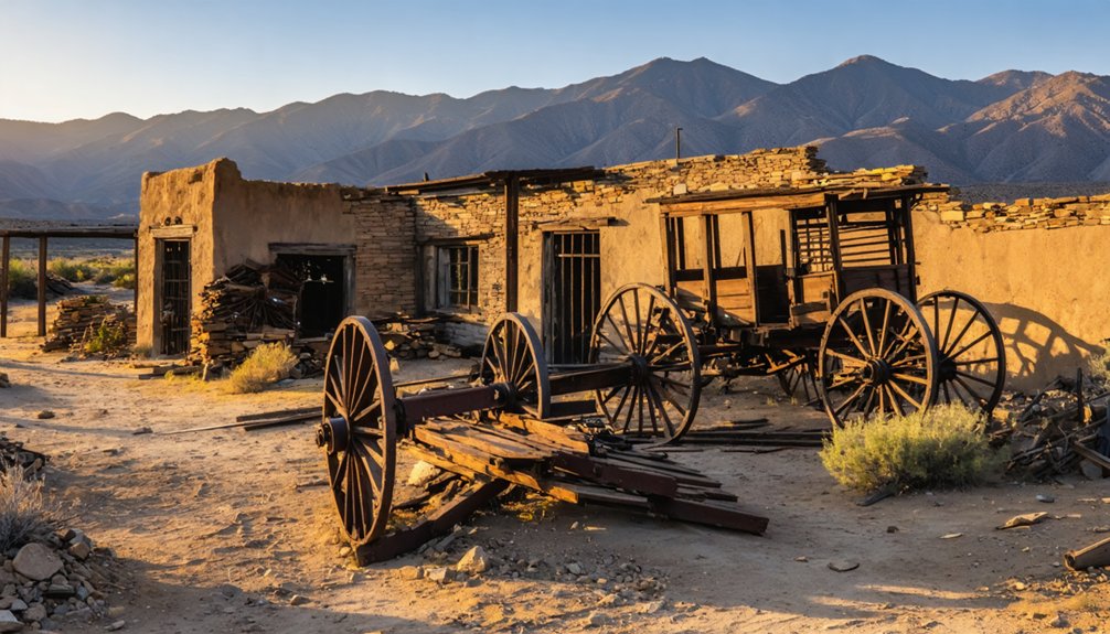
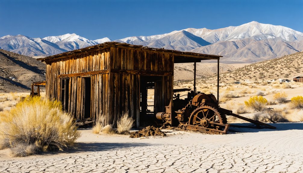
The Loop’s iron rails still hum with modern freight traffic, but thirty miles west in Bodfish, Silver City Ghost Town preserves the weathered timber and hand-forged hardware of the mining camps that predated Hood’s engineering triumph.
You’ll find authentic ghost town exploration within a 45-minute drive, where twenty relocated structures tell the mining legacy story of Kern County’s Gold Rush era.
Day-trip opportunities from Tehachapi Loop:
- Silver City Ghost Town features buildings from Claraville, Whiskey Flat, and Keyesville mining camps
- Preserved structures showcase mid-1800s construction techniques and arrested-decay authenticity
- Old Kernville, Havilah, and Keyesville sites offer partial ruins and historic cemeteries
- Abandoned ranch buildings and rail sidings dot the Tehachapi Pass corridor
- Tehachapi’s depot museum interprets the railroad-era settlement history
You’ll complete both railfanning and heritage exploration in one liberating journey through Kern’s layered past.
How Gold Fever Built and Abandoned These Communities
Gold fever transformed the Tehachapi region from a quiet agricultural corridor into a bustling gateway for desert prospectors during the 1890s Southern California mining boom.
You’ll find that discoveries like the 1893 Randsburg nugget—worth $60,000 today—sparked a gold rush that birthed entire mining camps overnight. Tent settlements evolved into towns with schools, churches, and literary societies.
Garlock exemplifies this pattern perfectly. When Eugene Garlock hauled his eight-stamp mill from Tehachapi in 1895, he created a processing hub that swelled to 200 residents.
But you’d watch these communities collapse just as rapidly. Once rail-linked mills opened in Randsburg and ore grades dropped, Garlock’s wagon-hauling advantage vanished. Merchants and miners chased newer strikes, leaving behind the ghost towns you’ll explore today.
Exploring the Outlaw History of Dick Fellows and Procopio
Before railroads and paved highways tamed Southern California’s backcountry, outlaws like Dick Fellows and Procopio haunted the very stage routes that fed Tehachapi’s mining camps and ranches.
Their exploits became part of regional outlaw folklore, blending fact with myth across abandoned freight corridors.
Bandit traditions shaped how locals remember these desperados:
- Dick Fellows earned notoriety for bungling robberies near Caliente, losing stolen gold down embankments and earning the nickname “outlaw who couldn’t ride a horse.”
- His targets included Wells Fargo stages linking Los Angeles to Tehachapi’s Southern Pacific railhead.
- Procopio Bustamante operated from vaquero culture, raiding ranches across Kern and Los Angeles counties.
- Both men cycled through capture, imprisonment, and return to crime.
- Their legacy survives in ghost-town lore where stagecoach routes disappeared.
What Remains: Preservation and Decay in Kern County Ghost Towns
Meanwhile, the source sites themselves offer mostly foundations and empty ground. Federal and state laws prohibit removing what little remains, yet architectural remnants continue vanishing through neglect and time.
Volunteer monitors patrol remote locations, documenting what persists. You’re left weighing two philosophies: curated relocation versus authentic erasure, both honest reflections of frontier impermanence.
Getting There: Directions and Accessibility
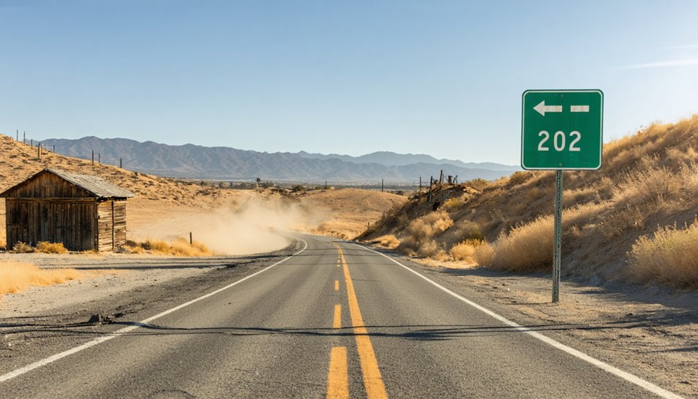
Since most Kern County ghost towns lie scattered across working railroad corridors and private ranchland, your best approach centers on Tehachapi as a staging point.
From there, you’ll navigate paved county roads with steep grades and tight curves that demand attention to road conditions and seasonal driving realities.
Key access points include:
- Caliente – Hwy 58 west to Bealville Rd, then 2.3 mi north; watch for winter snow/ice on grades
- Bealville – 0.9 mi north of Hwy 58 on Bealville Rd; brief roadside stop at historical marker
- Tehachapi Loop – Old State Hwy via Keene exit, 3.2 mi east to overlook; fog and wind affect visibility
- Fuel up in Tehachapi – limited services along corridor roads
- Cellular coverage sporadic in canyons; download maps beforehand
Large RVs face significant limitations on Caliente–Bodfish Rd’s winding climbs.
Allen’s Camp and Other Lesser-Known Abandoned Sites
Once you’ve parked at the established overlooks and historical markers, the real intrigue begins in the backcountry—where Allen’s Camp and its contemporaries blur the line between fading community and outright abandonment.
Originally Gabriel Allen’s 1870s ranching outpost, this site became Caliente when Southern Pacific Railroad arrived in April 1875, housing 3,000 workers—mostly Chinese laborers—during Tehachapi grade construction.
Today’s abandoned structures include rail-adjacent buildings, old sidings, and scattered homes conveying a near-ghost-town atmosphere. California Historical Landmark No. 757 marks the site’s historical significance as a 16-month railroad headquarters.
Surrounding rangeland and canyon terrain preserve Allen’s original pastures, while disused rights-of-way trace routes you can explore on foot, documenting transportation evolution from cattle trails to transcontinental rail.
Planning Your Visit: What to Expect When Exploring
Before you set out to explore these ghost towns, understand that each site presents distinct conditions ranging from well-maintained historical landmarks to hazardous ruins requiring caution and self-sufficiency.
Essential preparation includes:
- Bringing adequate water, navigation tools, and emergency supplies for remote locations
- Wearing sturdy footwear to navigate deteriorating structures and uneven terrain
- Respecting posted hours at managed sites like Silver City (10 a.m. to 4 p.m., $7.50 entry)
- Leaving historical artifacts undisturbed to preserve these irreplaceable resources
- Watching for rattlesnakes sheltering beneath debris and among local flora
You’ll find accessibility varies dramatically. While Caliente and Bealville sit just off Highway 58, other sites demand high-clearance vehicles and backcountry experience.
Document your route, notify someone of your plans, and embrace responsible exploration.
Frequently Asked Questions
Are There Guided Tours Available for the Ghost Towns Near Tehachapi?
Silver City Ghost Town offers guided exploration through structured visits with historical insights posted throughout buildings from the 1850s mining era. You’ll discover authentic artifacts and mannequin displays during operating hours, preserving freedom to explore independently.
What Time of Year Is Best for Visiting These Ghost Towns?
You’ll find spring (March–May) and fall (late September–November) offer the best seasons for exploration, with comfortable 60s–80s°F weather conditions that let you safely wander ruins without summer’s brutal heat or winter’s icy constraints.
Can You Camp Overnight Near the Ghost Town Sites?
Most Tehachapi-area ghost towns prohibit overnight camping directly on-site. You’ll find dispersed BLM camping nearby—often within 14-day limits—while respecting private property and historic landmarks. Check current camping regulations before exploring.
Are the Ghost Town Sites Safe for Children to Explore?
Ghost town exploration near Tehachapi isn’t inherently child-safe—you’ll encounter unstable structures, open mine shafts, and rattlesnake habitat. Managed sites like Silver City offer controlled access, but child safety demands constant supervision and sticking to designated areas only.
Do You Need Special Permits to Photograph the Historical Landmarks?
You’ll generally shoot freely for personal use, but commercial work needs permits. Like Ansel Adams maneuvering park rules, respect photography guidelines and historical preservation requirements—land ownership dictates access, and cultural sites demand extra care.
References
- https://www.youtube.com/watch?v=dsURyYgiBfc
- https://en.wikipedia.org/wiki/List_of_ghost_towns_in_California
- https://www.atlasobscura.com/places/silver-city-ghost-town
- https://www.barbaranusselphotography.com/blog/2017/4/20/wildflowers-and-ghost-towns-a-road-trip-through-central-california
- https://urbexology.com/geo/United States/Tehachapi/en.html
- https://freepages.rootsweb.com/~gtusa/history/usa/ca.htm
- https://www.legendsofamerica.com/caliente-nevada/
- https://www.youtube.com/watch?v=hQDrj1gi9XM
- https://www.cityofcaliente.com/about-caliente/history/
- https://travelnevada.com/historical-interests/caliente-railroad-depot/


