You’ll find four ghost towns scattered around Theodore Roosevelt National Park, each with distinct remnants and tragic histories. Little Missouri vanished completely by 1888, leaving only ground depressions and a roadside marker. Medora nearly joined it before tourism revival transformed the 1883 settlement. Grassy Butte’s Depression-era shells still stand amid dustbowl-scarred prairie, while Charbonneau survives as scattered foundations in McKenzie County’s backcountry. The catastrophic winter of 1886–87 killed 75% of cattle herds, collapsing these communities’ ranching economies—though understanding what happened requires examining the railroad consolidation, drought cycles, and homesteader hardships that followed.
Key Takeaways
- Medora, founded in 1883, collapsed by 1886 but was revived in 1962 as a tourism destination attracting 250,000 annual visitors.
- Little Missouri, established in 1880, vanished by 1888 due to harsh conditions, leaving only a roadside marker and ground depressions.
- The catastrophic 1886–87 winter killed up to 75% of cattle herds, destroying the open-range economy that sustained these settlements.
- Grassy Butte features standing Depression-era structures from the 1930s Dust Bowl that devastated the region’s agricultural economy.
- Ghost town sites require high-clearance vehicles, offline maps, and extra water due to remote gravel roads and limited cellular coverage.
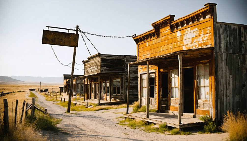
Medora: From Near-Abandonment to Gateway Community
In 1883, the Marquis de Mores envisioned Medora as a revolutionary cattle-to-market hub, establishing a meatpacking plant that would process beef on-site and ship it east in refrigerated railcars—eliminating the need to transport live animals.
The venture collapsed by 1886, and the brutal winter of 1886–1887—with temperatures plunging to -40°F and 90% cattle losses—shattered what remained of the local economy.
By the 1950s, just 130 residents lived among crumbling buildings without running water or sewer.
Then businessman Harold Schafer intervened in 1962, purchasing the vacant Rough Riders Hotel and painstakingly restoring it board-by-board.
Schafer had built his fortune manufacturing Mr. Bubble and Glass Wax through his Gold Seal Company, which he started in his basement in 1942.
The Medora revival transformed a near-ghost town into North Dakota’s premier tourism destination, welcoming a quarter-million visitors annually.
The Medora Musical, which has been entertaining audiences for nearly 60 years, became a cornerstone of the town’s cultural rebirth.
The Schafer legacy endures as Medora thrives as Theodore Roosevelt National Park’s gateway community.
Little Missouri (“Little Misery”): A Vanished Railroad Town
Unlike Medora’s dramatic rescue, Little Missouri—the original 1880 railroad settlement you’ll find no trace of today—vanished so completely that even its exact townsite boundaries remain debated among historians.
Founded a mile northwest of present-day Medora alongside the Badlands Cantonment, this rough depot town earned its “Little Misery” nickname through harsh conditions, extreme isolation, and the volatile mix of soldiers, railroad workers, and hunters who passed through Bob’s saloon and the Pyramid Park Hotel.
Within five years of welcoming presidents Grant and Arthur in 1883, the town had surrendered entirely to its rival across the river, leaving behind only archival mentions and the enduring question of what frontier promise looked like before it disappeared into the sagebrush. The drought of 1886 and the catastrophic winter that followed delivered the final blow to Little Missouri’s already declining fortunes. When the depot was sold and relocated to the HT Ranch forty miles south, the last tangible symbol of the town’s railroad identity departed with it.
Rough Frontier Origins
When the Northern Pacific Railroad laid tracks across the Little Missouri River in 1880, the raw settlement that sprouted on the west bank earned a nickname that stuck—”Little Misery.”
Located roughly a mile northwest of where Medora would soon rise, the town occupied a brutal stretch of the Badlands where rugged buttes, wind-scoured coulees, and relentless weather tested everyone who stepped off the train.
The site wasn’t empty when rails arrived. A year earlier, the Sixth Infantry had built Badlands Cantonment to provide military protection for construction crews pushing through territory recently taken from the Sioux.
Frank Moore’s post store became the settlement’s first trading hub. When soldiers withdrew, civilian businesses expanded around the depot—saloons, boarding houses, and supply shacks serving hard-drinking railroad workers, hunters, and cowboys.
The Little Missouri River itself rose in northeastern Wyoming near Devil’s Tower before flowing northward through the Dakotas to stitch together what would later become Theodore Roosevelt National Park.
Frontier lawlessness thrived in the isolation, making Little Missouri exactly what its bitter nickname promised. Local homesteaders profited by supplying railroad workers with food, building materials, and other necessities during the construction boom.
Complete Disappearance and Legacy
Within a few years of Medora’s founding in 1883, Little Missouri vanished so completely that today’s visitors scanning the ranchland northwest of Theodore Roosevelt National Park find no depot, no boardwalk, no trace of the rough settlement that once anchored the Northern Pacific’s push across the Badlands.
Abandonment reasons were stark: Morès’s meat-packing plant and stockyards drew rail traffic, freight, and capital across the river, stripping Little Missouri of its strategic role. The slaughterhouse capacity of 200 beeves daily reflected the industrial scale that attracted commercial interests to Medora’s east bank. The transient population—hunters, railroad crews, soldiers—lacked the permanence to resist economic gravity.
Yet the cultural significance endures. Little Missouri opened the Badlands to national audiences, hosting Chester A. Arthur’s hunting expedition and the Golden Spike Special. The railway tracks to Little Missouri were completed in 1880, marking the arrival of infrastructure that would briefly transform the remote Badlands crossing into a gateway for tourists and settlers. Its nickname “Little Misery” survives in oral tradition, memorializing a primitive gateway that shaped Roosevelt’s ranching legacy before disappearing entirely.
Grassy Butte and the Dust Bowl Legacy
Grassy Butte stands as a stark reminder of the Dust Bowl‘s devastating reach into North Dakota’s Badlands country. During the 1930s, severe drought and relentless wind stripped topsoil from plowed fields, turning once-productive farmland into barren wasteland.
You’ll find this settlement near Theodore Roosevelt National Park’s North Unit, where hundreds once lived before disaster struck.
The Economic Impact was catastrophic. Local merchants closed their doors when farmers couldn’t buy supplies. Arthur Rothstein’s 1936 FSA photograph documented one storekeeper “forced to close his general store on account of the drought.”
Foreclosures and abandonment followed, shrinking the population to mere dozens by century’s end. The Dust Bowl didn’t just damage land—it erased livelihoods, scattering families across a region that never fully recovered.
Community members gathered to pray for rain, seeking divine intervention as their only remaining hope against the relentless drought that gripped the plains. The federal government eventually provided emergency relief assistance, which reached as high as $1 billion in 1930s dollars by the end of the drought across the Great Plains.
Charbonneau and Schafer: McKenzie County’s Forgotten Settlements
- McKenzie County’s first creamery near the depot
- A business district with bank, newspaper, and hotel
- Blacksmith shop and lumber yard serving surrounding ranches
- John Deere dealership operating from a converted store
- Two-room schoolhouse accommodating local farm families
Schafer significance stems from its role as county seat from 1907 to 1941, anchoring government before Watford City’s rise.
Why Badlands Towns Disappeared: Cattle, Rails, and Drought
Though the Badlands ghost towns rose quickly alongside the Northern Pacific tracks, their collapse was equally swift—driven by economic shocks, environmental limits, and the railroad’s own evolving priorities.
You’ll find the catastrophic winter of 1886–87 killed up to 75% of open-range herds, wiping out Eastern investors and collapsing the cattle ranching economy that sustained trackside settlements.
Overstocked ranges had already degraded native grasses, and recurring droughts made recovery impossible.
Meanwhile, railroad impact proved equally decisive. When Northern Pacific consolidated operations, it closed section houses, downgraded sidings, and shifted freight to larger depots.
Towns dependent on single-commodity shipping—cattle, coal, or local hay—lost their economic foundation overnight.
Semi-arid conditions and flash flooding along unstable coulees finished what markets and corporate decisions began.
Exploring Ghost Town Remnants: Access and Landscape
Where you’ll actually find these ghost towns depends on which unit of Theodore Roosevelt you’re visiting and how far you’re willing to venture onto gravel section roads.
Exploring historic towns near Lassen Volcanic National Park can reveal fascinating insights into the region’s past. Many of these towns offer unique architecture and local museums that tell stories of the area’s rich history. As you stroll through their streets, you may encounter remnants of old mining operations and charming storefronts that have withstood the test of time.
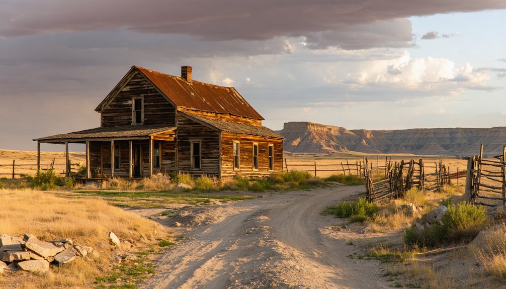
Little Missouri sits across the river from Medora’s South Unit entrance—just a roadside marker and ground depressions now.
Charbonneau lies west of the North Unit on empty highways through McKenzie County.
Grassy Butte straddles US-85 between units, its Depression-era shells still standing.
The historical significance emerges not from preserved buildings but from landscape context:
- Banded butte walls framing Medora’s original 1880s street grid
- Coal seams exposed along Little Missouri riverbanks where spur lines once ran
- Windswept prairie benches overlooking badlands drainages near northern ghost towns
- Shelterbelt tree rows marking abandoned Berthold farmsteads on section-line roads
- Scoria-capped ridges giving canyon-like backdrops to vanished commercial blocks
Planning Your Visit: Roads, Safety, and Etiquette
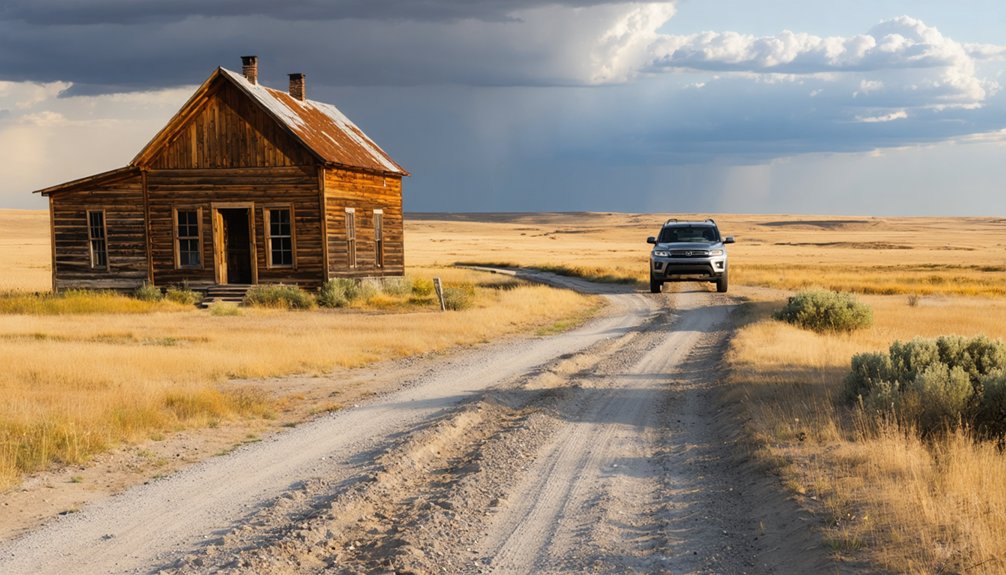
Before you set out to explore the weathered remains of homestead cabins and early ranching camps scattered across the Little Missouri Badlands, you’ll need to understand that many sites sit on a patchwork of federal, state, and private lands where access rules shift with every fence line.
The same gravel roads that served cattle drives and stagecoaches now require high-clearance vehicles in wet weather, and posted “No Trespassing” signs mark boundaries that weren’t there when these settlements thrived a century ago.
Always verify current road conditions with park rangers and confirm land ownership before stepping off established routes—prairie hospitality runs deep in western North Dakota, but respecting property lines guarantees these ghost-town remnants remain accessible for future visitors.
Road Conditions and Access
The paved corridors of Interstate 94 and U.S. 85 deliver you safely to park boundaries, but venturing toward ghost towns demands awareness of backcountry realities.
County and Forest Service gravel roads to sites like Elkhorn Ranch become treacherous when clay gumbo turns slick after storms. Road maintenance varies wildly across jurisdictions, and travel advisories during winter ground blizzards or spring thaw can strand you miles from help.
Conditions you’ll encounter reaching abandoned settlements:
- Washboarded ranch tracks crossing open prairie with no shade for thirty miles
- Unmarked intersections where oilfield roads mimic historic wagon routes on your map
- Coulees that flood within minutes during summer thunderstorms, cutting off retreat
- Soft roadbeds in April that trap even high-clearance vehicles axle-deep
- Navigation mismatches between signed local names and Forest Service route numbers
Download offline maps and carry extra water—cellular coverage won’t save you.
Respecting Private Property Boundaries
Because county plat books and barbed wire rarely align with the romance of exploration, you’ll need to master the unglamorous work of boundary research before chasing ghost towns across western North Dakota.
Many abandoned settlements sit on private ranch land, even when crumbling walls suggest public domain. Cross-check county assessor maps, NPS boundary data, and state land records to identify legal access routes—landlocked federal parcels offer no entry rights without crossing private ground.
North Dakota law respects property rights through posted signs, purple paint, and unposted boundaries alike. Gates, livestock, and two-track roads don’t grant permission.
Trespassing into ruins can escalate to criminal charges, trigger civil liability for fence damage, and strand you miles from help when ranchers enforce boundaries. Verify legal access or knock on doors; freedom depends on respecting others’ land.
Frequently Asked Questions
Are Any Ghost Towns Near Theodore Roosevelt National Park Completely Accessible to the Public?
Ironically, Medora’s “ghost town” thrives with tourists. You’ll find complete ghost town accessibility here—it’s Theodore Roosevelt National Park’s gateway with hotels, shops, and entertainment. Theodore Roosevelt history comes alive in this fully restored, commercially vibrant 1882 railroad settlement.
Can I Camp Overnight Near Ghost Town Sites in the Badlands Region?
Overnight camping near ghost town sites requires maneuvering camping regulations across federal, state, and private lands. You’ll find dispersed options on National Grassland, but always follow safety tips and respect protected historic resources.
What’s the Closest Ghost Town to the North Unit Entrance?
Time-worn Schafer stands closest to the North Unit entrance, its ghost town history woven into McKenzie County’s Badlands fabric. You’ll find this forsaken settlement southeast of Watford City, among nearby attractions dotting the Little Missouri corridor.
Are There Guided Ghost Town Tours Available From Medora?
No commercial guided tours run to ghost towns from Medora. You’ll find self-guided exploration your best option, though Medora history programs cover the town’s own near-ghost period before its 1960s revival.
Which Ghost Town Has the Most Remaining Original Structures Still Standing?
Tinton stands like a forest-frozen time capsule with the most abandoned buildings among Black Hills mining towns. You’ll discover its historical significance through numerous original structures slowly surrendering to reclaiming pines—a reflection of unfettered frontier ambition.
References
- http://www.onlyinyourstate.com/experiences/north-dakota/ghost-towns-nd
- https://medora.com/whatismedora/
- https://ghostsofnorthdakota892857007.wordpress.com/tag/mckenzie-county/
- https://www.youtube.com/watch?v=8GO57Im_dss
- https://writinforthebrand.com/little-misery-the-rise-and-fall-of-a-forgotten-badlands-town/
- https://lookaboutlindsey.com/why-you-need-to-stay-more-than-one-night-in-medora-north-dakota/
- https://en.wikipedia.org/wiki/List_of_ghost_towns_in_North_Dakota
- https://wheninyourstate.com/north-dakota/the-bizarre-reason-this-north-dakota-town-still-exists-bubble-bath/
- https://www.worldatlas.com/cities/why-this-north-dakota-town-deserves-more-attention.html
- https://www.achp.gov/preserve-america/community/medora-south-dakota


