You’ll find several remarkable ghost towns within an hour’s drive of Tombstone, each with its own mining legacy. Gleeson boomed with copper and turquoise operations until 1957, while Courtland’s concrete jail still stands from its 1908-1920 heyday. Pearce remains a “living ghost town” straddling Route 191, where the Commonwealth Mine produced $10.5 million in gold. Charleston and Millville processed Tombstone’s silver along the San Pedro River, and Fairbank served as the region’s essential railroad junction. The 50-60-mile Ghost Town Trail connects these historic sites for a complete exploration.
Key Takeaways
- Gleeson, Courtland, and Pearce are the main ghost towns near Tombstone, each featuring unique mining histories and preserved structures.
- Gleeson peaked at 6,000 residents during its copper boom, with the Copper Belle Mine operating until 1957.
- Courtland’s 1909 reinforced-concrete jail remains the most visible remnant after copper operations ceased in 1920.
- Pearce is a “living ghost town” with historic buildings including a jail, schoolhouse, and false-front storefronts along Route 191.
- The Ghost Town Trail offers a 50-60-mile loop through these sites, best visited October through April.
Gleeson: Turquoise and Copper Legacy
Long before copper transformed Gleeson into a booming mining camp, the Chiricahua Apache harvested turquoise from these hills on the south side of the Dragoon Mountains, crafting the blue-green stone into jewelry and trade goods.
White prospectors arrived to find copper, lead, and silver alongside the existing turquoise mining operations. The first settlement, aptly named Turquoise, established its post office in 1890 near El Frida, though it lasted only four years before gold lured residents to nearby Pearce.
The real copper boom began when John Gleeson started prospecting in 1900, discovering massive copper deposits that would redefine the region.
His Copper Belle Mine sparked a rush that brought mines like Silver Belle, Brother Jonathan, and Defiance, ultimately drawing 6,000 residents by 1918.
A devastating fire in 1912 swept through the town, destroying 28 buildings, but Gleeson’s residents quickly rebuilt their community. The Copper Belle Mine remained the town’s largest operation, continuing to extract ore until 1957.
Courtland: Ruins in the Dragoon Mountains
While Gleeson thrived on the north slopes, Courtland emerged at the southern tip of the Dragoon Mountains in 1908–1909 as one of Arizona’s most promising copper districts. Named for part-owner Courtland Young, the town exploded to 2,000 residents by the early 1910s.
Four major copper companies operated here, completing 8,000 feet of underground shafts. You’ll find Courtland history reflected in its infrastructure—two newspapers, hotels, stores, and even a horse-racing track served by dual railroad lines.
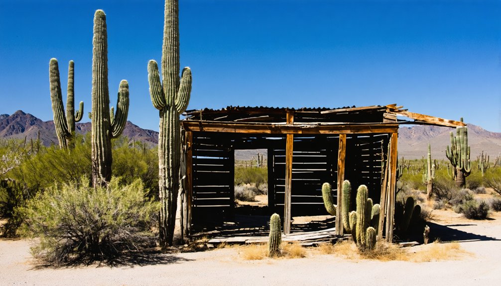
The mining legacy proved short-lived. By 1913, limestone beds reduced ore quality while copper prices dropped. Operations shuttered by 1920, and the post office closed in 1942. The town was completely abandoned by 1942, marking the end of its brief but intense 33-year existence.
Today, you can explore scattered ruins along Ghost Town Trail Road, where the reinforced-concrete jail stands as Courtland’s most visible remnant. Built in 1909 at a cost of approximately $1,000, the jail was constructed with reinforced concrete and steel and remains the only original structure from the town’s boom years.
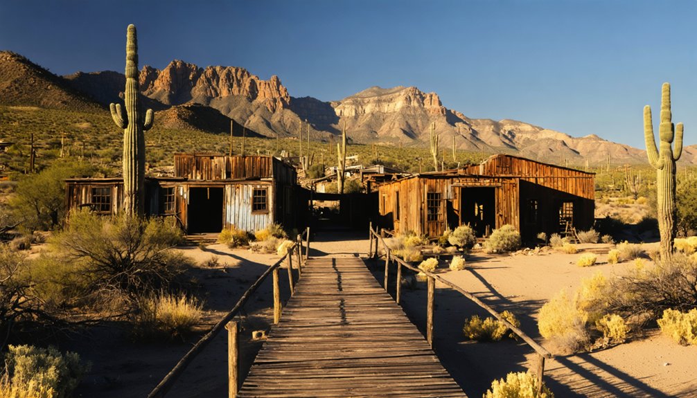
Pearce: A Living Ghost Town
You’ll find Pearce straddling U.S. Route 191 in the Sulphur Springs Valley, where James Pearce’s 1894 gold strike at the Commonwealth Mine sparked a rush that drew 1,500 residents by 1919.
The town preserves a collection of original buildings—including an 1915 jail, an operating 1912 schoolhouse, and several historic storefronts—that earned it designation as a “living ghost town” along the regional Ghost Town Trail.
After the Commonwealth Mine exhausted its ore and closed in the late 1940s, Pearce evolved from bustling mining hub to semi-abandoned community, where heritage tourism now sustains a handful of shops and the Old Pearce Preservation Association’s interpretive efforts. The historic Pearce Jail opens to visitors on the first Saturday of each month from October through May, offering glimpses into the town’s law enforcement past. Before its transformation into a mining town, Pearce became the local Wild West destination when families and businesses relocated from nearby Tombstone, seeking new opportunities in the gold fields.
Gold Rush Heritage
When James Pearce struck gold in 1894–1895 at what became the Commonwealth Mine, he ignited a rush that shifted the Sulphur Springs Valley’s economic center away from flooded Tombstone.
The gold rush drew families and entrepreneurs who built mining communities practically overnight—Joe Bignon hauled his entire house to Pearce in March 1896 just to open the Pioneer Saloon.
By 1919, you’d have found 1,500 residents supported by hotels, stores, a school, and even a movie theater.
The Commonwealth churned out over a million tons of ore worth $8 million in silver and $2.5 million in gold before closing in the late 1940s.
The Old Pierce Merkantile, constructed in 1895, served as both general store and banking center for miners and ranchers throughout the boom years.
During peak production years, silver sold for approximately 50 cents an ounce while gold commanded $20 per ounce.
Today you’ll discover a “living” ghost town where heritage events and historic remnants attract visitors exploring Arizona’s mining legacy.
Delve into the history of Tombstone, Arizona, where iconic sites like the O.K. Corral transport you back to the Wild West. The rich narratives of gunfighters and lawmen continue to resonate, making it an essential stop for history enthusiasts. As you walk the streets, you’ll feel the spirit of a bygone era come alive through detailed exhibits and reenactments.
Exploring ghost towns around Page Arizona offers a different glimpse into the region’s mining past. Each site has its own unique story, beckoning those interested in the remnants of old settlements and the lives once lived there. From crumbling buildings to silent streets, the haunting beauty of these locations invites adventurers to uncover the secrets of Arizona’s history.
Preserved Historic Structures
That century of activity left a remarkable physical legacy you can still explore today.
Pearce’s commercial core preserves authentic false-front buildings along the Ghost Town Trail, including the Old Pearce Store and period saloon structures. The 1915 jail and 1912 schoolhouse—still functioning for education—anchor a civic cluster that demonstrates the town’s architectural significance as a regional center.
You’ll find original wood-frame and adobe residences arranged along the historic grid, some relocated from Tombstone during the boom years.
The Pearce Cemetery, maintained by local volunteers, documents generational continuity from mining days forward. The Commonwealth Mine emerged as one of Arizona’s most productive silver operations, with approximately 20 miles of underground workings carved beneath the community.
This “living ghost town” balances occupied homes with abandoned shells, creating an uncommonly authentic frontier streetscape where historic preservation serves daily life rather than static museum display.
Semi-Abandoned Community Today
Today Pearce exists as what tourism sources aptly call a “sometimes lively ghost town”—an unincorporated community in Cochise County where only a handful of full-time residents occupy the historic townsite itself, while a larger modern population lives in nearby Sunsites.
The community atmosphere centers on quiet, solitude, and rural desert lifestyle, attracting those seeking seclusion in southeastern Arizona’s high-desert landscape.
You’ll find small, intermittently open shops like Patty’s Old Pearce Pottery and the Prickly Pear Emporium supporting light commerce.
The Old Pearce Mercantile serves multiple roles as historic site, museum, and event venue.
Periodic street fairs and vendor gatherings temporarily enliven the town, while its inclusion on the regional Ghost Town Trail linking to Tombstone demonstrates ongoing tourism potential despite the dramatic population decline from 1,500 residents in 1919. The Ghost Town Trails experience has earned recognition with a Travelers’ Choice award for consistently great reviews from visitors exploring the area’s historical sites and scenic hiking opportunities.
Charleston and Millville: Tombstone’s Lost Mill Towns
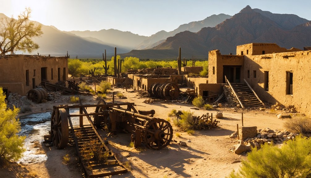
While Tombstone’s mines produced the silver, Charleston and Millville on opposite banks of the San Pedro River transformed that ore into bullion bars ready for shipment.
These twin mill towns processed millions of dollars worth of silver during the early 1880s, operating massive stamp mills that ran day and night to support Tombstone’s boom.
Today you’ll find scattered ruins along the riverbanks—crumbling adobe walls, mill foundations, and cemetery markers—all that remains of communities that once housed hundreds of workers in Arizona’s integrated mining district.
Processing Silver for Tombstone
Because Tombstone’s arid hills couldn’t supply the water needed for large-scale ore processing, the district’s mining boom depended entirely on mills built eight to nine miles west along the San Pedro River.
Millville’s stamp mills crushed ore hauled by sixteen-mule teams carrying 40,000–50,000 pounds daily from Tombstone’s mines. The silver processing technology relied on heavy stamps that pulverized ore fed from upper levels, creating gravity-driven flow through successive amalgamation stages.
Water from the San Pedro powered the machinery and enabled chemical refining impossible in Tombstone itself. During peak operations in 1881–1882, this mill infrastructure produced $1.3–$1.4 million in silver bullion annually, operating around the clock with workers housed in nearby Charleston.
The entire district’s wealth flowed through these riverbank facilities.
What Remains Today
Little remains of the mill towns that once processed Tombstone’s silver fortune along the San Pedro River. At Millville, you’ll find stone ruins of two buildings and adobe foundations accessible via a 2.5-mile established trail with informational signs marking the stamp mill sites.
The Millville ruins offer designated exploration for those seeking tangible connections to Arizona’s mining past.
Charleston tells a different story. Charleston accessibility requires traversing unmarked brush without established trails, deterring most visitors. The 1887 Sonoran earthquake devastated its adobe and wood-framed structures, and Mexican immigrants dismantled remaining materials for firewood in the early 1890s.
Today, only scattered adobe ruins mark where Charleston once thrived. Both ghost towns officially died by 1889 when the silver ran out.
Fairbank: Railhead on the San Pedro River
The New Mexico & Arizona Railroad reached the area by 1882, followed by Phelps-Dodge’s Arizona & Southeastern line from Bisbee in 1888.
By the late 1880s, Fairbank’s depot area bustled with four stores, five saloons, and a Wells Fargo office handling ore, supplies, and stagecoach passengers.
In 1903, the El Paso & Southwestern built a spur directly to Tombstone, cementing Fairbank’s junction status until highways and trucks displaced short-line rail traffic.
Planning Your Ghost Town Trail Adventure
While Fairbank served travelers arriving by rail, today’s visitors explore these remnants of Arizona’s mining era by road.
Tombstone anchors a roughly 50–60-mile loop known as the Ghost Town Trail****, threading through Pearce, Courtland, and Gleeson via AZ-80 and a network of ranch roads.
Road trip logistics demand attention: fuel up in Tombstone, carry offline GPS and detailed Cochise County maps, and plan for spotty cell coverage across ranch country.
October through April offers ideal temperatures; summer heat exceeds 100°F, and monsoon flash-floods can close dirt segments July–September.
Safety precautions include high-clearance vehicles for washboard stretches, rattlesnake awareness, and respecting posted boundaries—much of the trail crosses private and state trust land.
Abandoned mine shafts require caution, and artifact removal is prohibited.
Stay on existing tracks and observe structures from safe distances.
What to Expect When Visiting Arizona Ghost Towns
Visitor safety demands attention to open mine shafts, unstable structures, and desert conditions including extreme heat, rattlesnakes, and limited shade.
Most developed sites provide marked trails and supervised access, but remote locations require self-reliance. Pack water, wear sturdy boots, and respect posted warnings.
The high-desert environment means intense sun, rough terrain, and minimal services at many locations.
Frequently Asked Questions
Are Any Ghost Towns Near Tombstone Privately Owned and Off-Limits to Visitors?
While some ghost towns near Tombstone have private ownership, most maintain public access as tourist attractions. Charleston faces natural access restrictions due to lack of infrastructure rather than deliberate closure. You’ll find most sites welcome visitors.
What Wildlife Hazards Should I Watch for When Exploring Ghost Towns?
Like Wyatt Earp scanning shadows, you’ll face rattlesnakes in ruins, mountain lions at dusk, and scorpions under debris. Wildlife encounters demand constant vigilance—visual checks before reaching, avoiding dawn/dusk exploration, and respecting escape routes guarantee safety precautions work.
Can I Camp Overnight Near the Ghost Town Sites?
Overnight camping near ghost towns depends on camping regulations and land ownership. You’ll need overnight permits for dispersed sites on national forest land, while many townsites on private property prohibit camping entirely without explicit permission.
Do Any Ghost Towns Offer Guided Tours Year-Round?
Commercial operators run guided tours to Gleeson, Courtland, and Pearce year-round, though seasonal availability depends on weather and bookings. Most ghost town sites themselves remain self-guided, with Gleeson’s jail museum open monthly only.
Are the Roads to Ghost Towns Passable in Standard Vehicles?
Most ghost town roads near Tombstone accommodate standard vehicles—Fairbank via paved AZ-82, Gleeson on maintained graded dirt. Road conditions vary seasonally; vehicle recommendations include high-clearance for Charleston’s primitive tracks and post-monsoon travel when flash-flood risks subside.
References
- https://www.arizonahighways.com/article/arizona-ghost-towns
- https://en.wikipedia.org/wiki/List_of_ghost_towns_in_Arizona
- https://www.youtube.com/watch?v=z1iGbFJH0L8
- https://southernarizonaguide.com/ghost-towns-southern-arizona/
- https://www.visitarizona.com/like-a-local/arizonas-ghost-town-getaways
- https://www.visittucson.org/blog/post/8-ghost-towns-of-southern-arizona/
- https://www.atlasobscura.com/things-to-do/arizona/ghost-towns
- https://www.tripadvisor.com/ShowUserReviews-g60778-d108693-r265961121-Fairbank_Historic_Townsite-Hereford_Arizona.html
- https://www.legendsofamerica.com/az-ghosttowntrail/
- https://thepaintedhawk.wordpress.com/ghost-town-of-gleeson/


