You’ll find six major ghost towns within two hours of Tonopah, spanning Nevada’s 1865-1920 mining boom. Belmont, the former Nye County seat, showcases weathered buildings from its 1866 silver rush peak. Tybo’s canyon holds charcoal kilns and smelter ruins from the 1870s silver-lead era. Goldfield, once Nevada’s largest city with 30,000 residents, still houses 200 people among its historic structures. Millers and Coledale mark abandoned railroad and highway service stops along Route 95. Spring and fall circuits covering 150-300 miles reveal Nevada’s documented 800 ghost towns across these counties.
Key Takeaways
- Tonopah serves as the central hub for exploring over 800 ghost towns across Nye and Esmeralda counties in Central Nevada.
- Belmont, a former county seat established in 1865, features weathered buildings and a historic courthouse from its silver mining era.
- Tybo offers remnants of 1870s silver-lead mining including smelter foundations, charcoal kilns, and the historic Trowbridge Store.
- Goldfield, once Nevada’s largest city with 30,000 residents, now houses 200 people with preserved architecture and basic visitor services.
- Millers and Coledale are accessible ghost towns featuring railroad remnants and abandoned highway service infrastructure respectively.
Belmont: Silver Boomtown and Former County Seat
Silver strikes in 1865 transformed a barren stretch of central Nevada’s Monitor Range into Belmont, one of the territory’s most significant mining camps.
You’ll find records of ore assaying $3,000 per ton, sparking a stampede in 1866 that built a town of roughly 2,000 residents.
Belmont’s political clout earned it Nye County seat status in 1867, with the courthouse anchoring a commercial district of stores, saloons, and two newspapers.
The boom proved short-lived—declining ore grades by 1868 sent miners chasing White Pine’s promises.
A 1915 revival using improved mining techniques briefly rekindled operations before final collapse.
The town sits at 7,424 feet elevation, where high desert conditions shaped daily life for miners and merchants alike.
Today, you can explore Belmont’s courthouse, jail, and stone ruins off-grid, north of Tonopah, where desert silence replaced frontier ambition.
The site now draws photographers and history enthusiasts who document the weathered buildings and capture the haunting beauty of Nevada’s mining heritage.
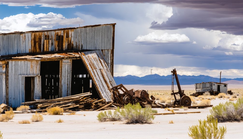
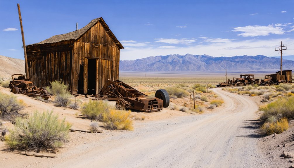
Tybo: Gold Rush Remnants in the Hot Creek Range
About 60 miles east of Tonopah off U.S. Route 6, Tybo’s scattered ruins mark a once-thriving 1870s silver-lead camp that briefly rivaled Eureka in ore production.
You’ll find remnants of smelter foundations, charcoal kilns, and building walls in Tybo Canyon, where three ethnically divided neighborhoods housed nearly 1,000 residents at the camp’s 1876–1877 peak.
The site remains accessible via dirt roads into the Hot Creek Range, though little intact infrastructure survives beyond stone and brick foundations documented in historic photographs and mining district records. Despite ethnic divisions among Irish, Cornish, Central European, and Chinese residents, all children attended the same brick school together. The Trowbridge Store still stands as one of the few intact structures, having served both as a general store and later as a community recreation hall.
Historic Mining Infrastructure Remains
Scattered across the Hot Creek Range near Tybo, multiple stone charcoal kilns stand as Nevada’s most concentrated remnants of 19th-century fuel-production infrastructure.
At peak operations in the early 1870s, mining smelters consumed 530 cords of piñon wood daily, stripping roughly 4,000 acres per kiln group. You’ll find intact masonry, loading doors, and draft vents illustrating European-style technology adapted to desert conditions.
Beyond the kilns, slag dumps and machinery footings mark where thirteen smelters processed silver-lead ore. The 1929 flotation mill introduced modern ore-reduction methods for eight years.
Stagecoach stations still shadow Morey Peak, preserving transport routes that connected Upper Town and Lower Town. Wagon ruts, grade cuts, and borrow pits document the logistics network that moved ore, charcoal, and supplies through this autonomous mining frontier. The Tybo Mining district was organized in 1870, transforming the region into a major transportation center that linked multiple mining communities until its eventual decline in 1891. Welsh miners worked trails southwest of Hot Creek Canyon during the 1870s, their distinctive singing echoing across the mountainsides as they prospected for gold.
Access and Visitor Information
Reaching Tybo requires approximately seventy road miles from Tonopah—a journey of one to one-and-a-half hours through central Nevada’s remote high desert mountains.
Access routes begin at US Highway 6, turning onto graded dirt roads that demand high-clearance vehicles in dry conditions. The BLM-managed townsite offers free public access, though you’ll encounter private property boundaries marked by signage throughout the settlement.
Essential visitor guidelines include:
- Respect private parcels among the ruins—occupied homes and individually owned structures require you to stay on public routes
- Practice “Stay Out, Stay Alive” protocols around open mine shafts, adits, and unstable tailings piles scattered through the canyon
- Prepare for backcountry conditions with no services available; fuel up in Tonopah and carry adequate water for extreme summer heat
- Bring protective equipment such as steel-toe waterproof boots, headlamps, and gloves for safely exploring mining remnants
Artifact removal violates federal land-use regulations.
The site maintains 24/7 public access year-round, allowing spontaneous visits at any time of day.
Goldfield: Nevada’s Living Ghost Town
Thirty miles south of Tonopah on U.S. 95, you’ll encounter Goldfield—once Nevada’s largest city during its 1900s-1910 heyday, now home to roughly 200 residents and some of the state’s most intact boomtown architecture.
exploring goldfield’s historical significance reveals the tales of miners and dreamers who flocked to this once-bustling hub in search of fortune. Many artifacts and buildings from that era remain, serving as a testament to the vibrant community that once thrived here. Visitors today can stroll through the remnants of Goldfield, immersing themselves in the rich narrative of Nevada’s mining past.
The district yielded $86–90 million in gold between 1903 and 1940, financing brick commercial blocks, a county courthouse, and the ornate Goldfield Hotel that still anchor the historic core. Gold was first discovered in 1902, transforming the area into a major mining center within just a few years.
Today’s visitor finds a working community threaded through documented ruins, where five-bank prosperity and labor strikes share streetscapes with modern amenities along this lonely desert highway. The Goldfield Historic Cemetery features notable graves including the famous Paste Eater’s Grave, veterans, and Serbian plots, divided into sections for Firemen and Freemasons.
Historic Architecture and Landmarks
Goldfield’s architectural legacy stands as a tribute to boom-era ambition frozen in stone and brick.
You’ll discover the 1907–1908 Esmeralda County Courthouse, a medieval-castle design built from native sandstone for $80,000, still functioning as the county seat with original Tiffany lamps intact. This commitment to historic preservation saved the structure when the 1923 fire consumed 25 blocks.
The architectural styles range from civic monuments to commercial grandeur:
- Goldfield Hotel: Four-story brick landmark with 150 rooms, steam heat, and elevator—costing $450,000 at peak prosperity
- Nixon & Wingfield Block: Three-story financial hub housing Cook Bank and mining offices
- Fire Station #1: Stone fortress serving until 2002, exemplifying coordinated fire-mitigation planning
Scattered wooden houses, garages, and authentic saloons complete this rare intact mining-town core.
Gold Rush Legacy
When prospectors struck gold in 1902, they triggered a transformation that would briefly make this remote Nevada camp the state’s largest and wealthiest city.
You’ll find Goldfield’s gold rush legacy in its surviving brick buildings and empty streets—a population that once swelled to 30,000 now numbers under 300.
The camp’s mining legacy shaped Nevada’s political and economic center of gravity, with daily ore production reaching $10,000 during peak years.
Labor strikes, resource depletion, and catastrophic fires—including the devastating 1923 blaze that consumed 27 blocks—ended the boom by the 1920s.
Today, you’re walking through what locals call a “living ghost town,” where the Queen of Mining Camps persists as evidence of frontier ambition and inevitable decline.
Visitor Access and Amenities
Unlike many abandoned Nevada mining camps, Goldfield maintains just enough year-round residents—roughly 200 to 250—to support basic visitor services along U.S. Highway 95.
You’ll find no general admission fee to explore the historic district‘s streets and exterior sites. Parking is available near the courthouse, hotel, and saloon-fronted visitor center.
Visitor tips for planning your stop:
- Local cuisine options remain limited to the Dinky Diner and casual saloon fare; fuel services operate at older two-pump stations with expanded options in Tonopah.
- Cell coverage exists but reflects rural service levels across this remote desert community.
- Year-round highway access is typical, though desert heat and occasional winter conditions require seasonal awareness.
Sixty miles south of Tonopah, Goldfield offers primitive camping near the Car Forest and exceptional dark skies for stargazing.
Millers: Abandoned Railroad Service Stop
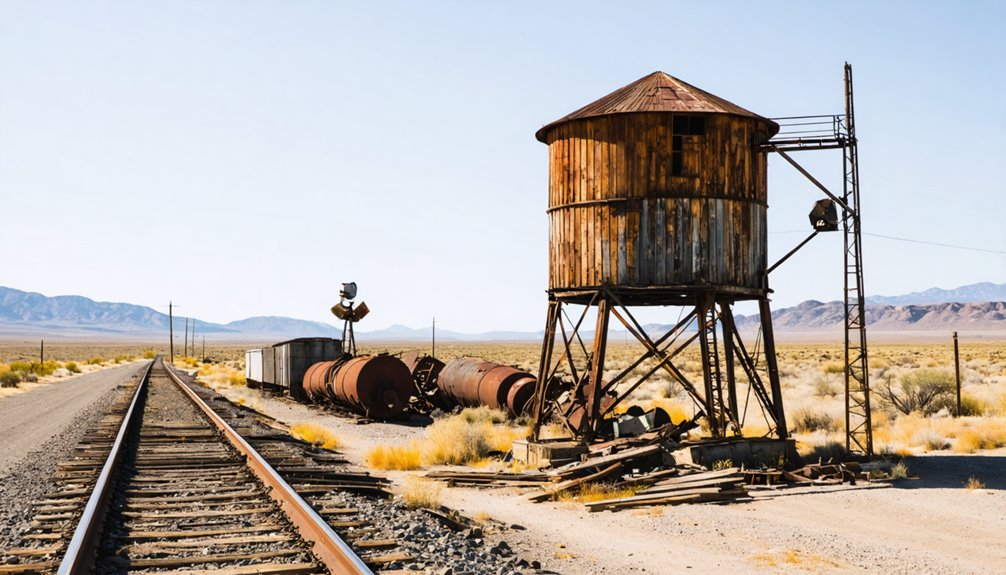
Roughly ten miles west of Tonopah, Millers emerged in 1904 as a purpose-built railroad service town along the Tonopah & Goldfield Railroad, occupying ground where Desert Wells Station had served stagecoach traffic since around 1866.
Railroad history shaped every aspect of this settlement, which hosted a massive roundhouse, turntable, and repair shops that serviced locomotives hauling ore from surrounding districts.
By the late 1900s, 250 residents supported two stamp mills processing Tonopah ore, a business district, and even a baseball park with grandstands—evidence of community legacy rooted in industrial prosperity.
The town’s decline mirrored its rise: when railroad shops relocated to Goldfield in 1910 and milling operations shifted elsewhere, Millers faded rapidly.
Rail service ended in 1947, leaving only scattered foundations visible near today’s Miller’s Rest Area.
Coledale and Highway 95 Corridor Relics
Coal fever arrived in the remote desert thirty miles west of Tonopah in 1894, when prospector William Groszenger stumbled upon deposits that promised industrial transformation.
Dr. Frances Williams championed Coaldale history through aggressive townsite promotion circa 1903–1905, selling stock in a future coal-powered city. U.S. Geological Survey geologists crushed those dreams, declaring the fuel non-commercial grade.
Coaldale reinvented itself as Highway 95’s critical pit stop:
- Junction hub where Routes 95 and 6 converged, serving cross-Nevada travelers
- Service complex featuring 12-room motel, restaurant-bar-casino, and general store
- EPA shutdown in 1993 after leaking fuel tanks forced permanent closure
Highway relics scatter across the junction today—empty buildings marking where motorists once refueled before tackling Nevada’s vast emptiness.
The ghost town stands abandoned since the mid-1990s.
Planning Your Central Nevada Ghost Town Loop
From Coaldale’s shuttered junction, you’ll find yourself poised at the edge of Nevada’s richest concentration of abandoned mining camps—more than 800 documented ghost towns scattered across Nye and Esmeralda counties alone.
As you venture further, consider exploring the ghost towns near Winnemucca Nevada, where remnants of the past whisper stories of fortune and failure. Each crumbling structure offers a glimpse into a once-thriving community, now left to the embrace of the desert. These sites are not only a window into history but also serve as a canvas for nature’s reclamation.
Smart loop planning starts in Tonopah, your natural hub for radiating 150–300 mile circuits north to Highway 50’s deserted stretches, south through Goldfield to Rhyolite’s concrete ruins, or east along US-6 past Warm Springs’ derelict bathhouse.
Tonopah anchors your exploration radius—150 to 300 miles of desolate highways connecting Nevada’s most accessible ghost town clusters.
Effective ghost town navigation demands county-by-county maps downloaded before you leave cell coverage, fuel topped at every opportunity, and high-clearance vehicles for graded mine roads.
Spring and fall offer comfortable exploration windows; plan early starts to maximize daylight on unlit desert routes.
You’re threading together a century of boom-and-bust history across landscapes where ghost towns genuinely outnumber the living.
Frequently Asked Questions
Are Camping or Overnight Stays Permitted at Any Ghost Town Sites?
Overnight stays aren’t permitted directly at protected ghost town sites, but you’ll find dispersed BLM camping nearby without overnight permits required. Camping regulations allow 14-day stays within 28-day periods on surrounding public lands.
Which Ghost Towns Require High-Clearance or Four-Wheel-Drive Vehicles to Access?
Tybo Kilns and Coalville demand high-clearance 4WD due to washed-out sections and rough terrain. These off road adventures require capable vehicle requirements—bring a truck, Jeep, or ATV to safely explore Nevada’s remote backcountry sites.
Can I Legally Remove Artifacts or Souvenirs From Ghost Town Locations?
Hands off—artifact preservation is non-negotiable. Legal regulations prohibit you from removing even nails or bottles from ghost towns on federal or state land near Tonopah. Permits are required; violations carry steep fines and potential felony charges.
Are Guided Tours Available for Any Tonopah-Area Ghost Towns?
You won’t find formal guided tours specifically for ghost towns near Tonopah, but you’re free to explore independently. Self-guided exploration lets you discover local history at nearby sites like Belmont and Gold Point on your own terms.
As you wander through the area, you may come across ghostly tales of Tonopah, Nevada that echo the mining boom of the past. The stories of lost fortunes and eerie encounters bring life to the remnants of forgotten structures. Each step in this hauntingly beautiful landscape unveils a new chapter of the region’s rich and mysterious history.
What Cell Phone Coverage Exists at These Remote Ghost Town Sites?
You’ll find virtually no cell service at Belmont, Warm Springs, and similar remote sites. Network reliability drops to zero miles before you arrive, so pack offline maps, satellite communication, and self-reliance tools for these off-grid Nevada destinations.
References
- https://nvtami.com/top-10-ghost-towns-nevada-northwest/
- https://travelnevada.com/ghost-town/belmont-ghost-town/
- https://nvtami.com/2022/07/16/to-tonopah-beyond/
- https://travelnevada.com/ghost-town/tybo-ghost-town/
- https://findingnevadawild.com/goldfield-the-old-west-lives-in-nevadas-best-ghost-town/
- https://www.tripadvisor.com/ShowTopic-g45963-i10-k11279175-Ghost_towns_near_Tonopah-Las_Vegas_Nevada.html
- https://forgottennevada.org/sites/newlist.html
- https://westernmininghistory.com/towns/nevada/belmont/
- https://www.pbslearningmedia.org/resource/nevada-ghost-towns-video-gallery/outdoor-nevada/
- https://en.wikipedia.org/wiki/Belmont


