You’ll find over a dozen ghost towns within 90 miles of Tucson, remnants of Arizona’s 1870s-1920s mining boom. Kentucky Camp preserves five 1904 adobe structures from the Santa Rita Water & Mining Company, while Gleeson’s 1910 jail still stands among hospital ruins. Harshaw once housed 2,000 souls after its 1877 silver strike, though most buildings were demolished in the 1960s. Fort Bowie marks Apache Wars history near Apache Pass. Fairbank served Tombstone’s silver operations as a significant transportation hub. The following sections reveal specific access routes, preserved landmarks, and essential safety considerations.
Key Takeaways
- Kentucky Camp, established in 1874, features five preserved adobe structures and offers Forest Service-maintained camping facilities for visitors.
- Gleeson preserves notable landmarks including a 1910 jail-turned-museum, hospital ruins, and remnants from its 1912 copper mining peak.
- Harshaw’s 1877 silver strike created a 2,000-person town; scattered adobe walls, foundations, and a hillside cemetery remain today.
- Fort Bowie’s stone ruins mark the Apache Wars headquarters from 1862 until Geronimo’s 1886 surrender at Apache Pass.
- Fairbank served as Tombstone’s transportation hub in the 1880s, with remnants including the 1900 train robbery site still visible.
Kentucky Camp: A Well-Preserved Mountain Mining Camp
In 1874, when prospectors struck gold approximately two miles north of what would become Kentucky Camp, they triggered a rush that brought over 500 miners to the rugged terrain near Greaterville.
You’ll find five adobe structures dating to 1904, when the Santa Rita Water & Mining Company established its headquarters here. Their ambitious 8½-mile water system powered hydraulic monitors that blasted hillsides with 100-foot streams.
The company’s fortunes took a devastating turn when James B. Stetson, the mining engineer attempting to solve the camp’s water supply issues, died under mysterious circumstances after falling from his hotel room in Tucson in May 1905. After the company’s collapse in 1906, Kentucky Camp transformed into ranch headquarters until 1965. The Forest Service acquired it in 1989, making historic preservation a priority. The Friends of Kentucky Camp, established in 1995, continues to aid in stabilizing and restoring the remaining adobe buildings.
Today, you can explore the assay office where miners tested gold samples and walk among Southern Arizona’s richest placer deposits—a tangible connection to the West’s mining heritage.
The Ghost Town Trail: Gleeson, Courtland, and Pearce
Gleeson’s landscape tells the story of southern Arizona’s boom-and-bust mining economy through its scattered architectural remnants—foundations, crumbling walls, and the unrestored jail building that survived a century of desert weather.
The town’s mining cycle began with Chiricahua Apache harvesting turquoise for ornamental use, then exploded into industrial-scale copper extraction after John Gleeson’s discovery triggered an Anglo-American rush roughly 16 miles east of Tombstone. A post office opened on October 15, 1900, serving a community that would eventually support about 500 residents at its peak.
You’ll find the Gleeson Jail Museum opens its doors on the first Saturday of each month from 9 a.m. to 4 p.m., offering archival access to this copper camp’s brief but intense period of productivity before the inevitable collapse. The trail continues to Courtland, a former boomtown that once supported 2,000 residents in the early 1900s with amenities including a newspaper and movie theater before the desert reclaimed it after the mines closed around 1920.
Gleeson’s Historic Structures
Time and fire have left Gleeson with a handful of skeletal survivors—concrete, adobe, and stone structures that tell the story of a copper boomtown that peaked around 1912.
The reinforced-concrete Gleeson Jail, built for $1,778 in 1910, stands as the town’s most recognizable landmark. It’s an exact duplicate of Courtland’s jail and survived the devastating 1912 fire that consumed most wooden buildings. The jail operates as a museum with hours that vary based on volunteer availability.
North of the main street, you’ll find the Hospital Ruins—crumbling adobe walls that once served 500 miners. Built in the mid-1910s by the Shannon Mine Company, it functioned as the only medical facility for Gleeson and surrounding communities until closing in the late 1930s.
The Joe Bono building, originally a saloon and mercantile outlet, remains fenced but visible.
At 6053 W Gleeson Road, the Old Miner’s Home—built by Mexican immigrants Juan and Theresa Martinez in 1901—represents the last early residence standing.
Boom-and-Bust Mining Cycle
Long before the brick-and-mortar storefronts rose along Gleeson’s main street, Chiricahua Apache miners extracted turquoise from the Dragoon Mountains, establishing the district’s mineral heritage centuries before Euro-American prospectors arrived with their assay kits and claim stakes.
The 1894 Commonwealth gold strike near Pearce ignited the first rush, draining Turquoise camp overnight. You’ll find mining history mirrors economic cycles perfectly here: John Gleeson’s 1900 copper discoveries triggered railroad spurs and populations of 2,000 in Courtland by 1910.
World War I copper demand peaked Gleeson’s output, but post-war price collapses and depleted ore bodies killed Courtland by 1920. The Great Depression delivered the final blow—Gleeson’s last mines shuttered around 1940, leaving abandoned headframes silhouetted against desert sunsets. During the 1930s Depression years, minor placer operations extracted gold from gravels east of town, averaging $1.12 per cubic yard from tested deposits.
Today, Gleeson Jail stands as a restored museum after 2007 renovations, one of the few boom-era buildings still serving the handful of residents who remain in this ghost town.
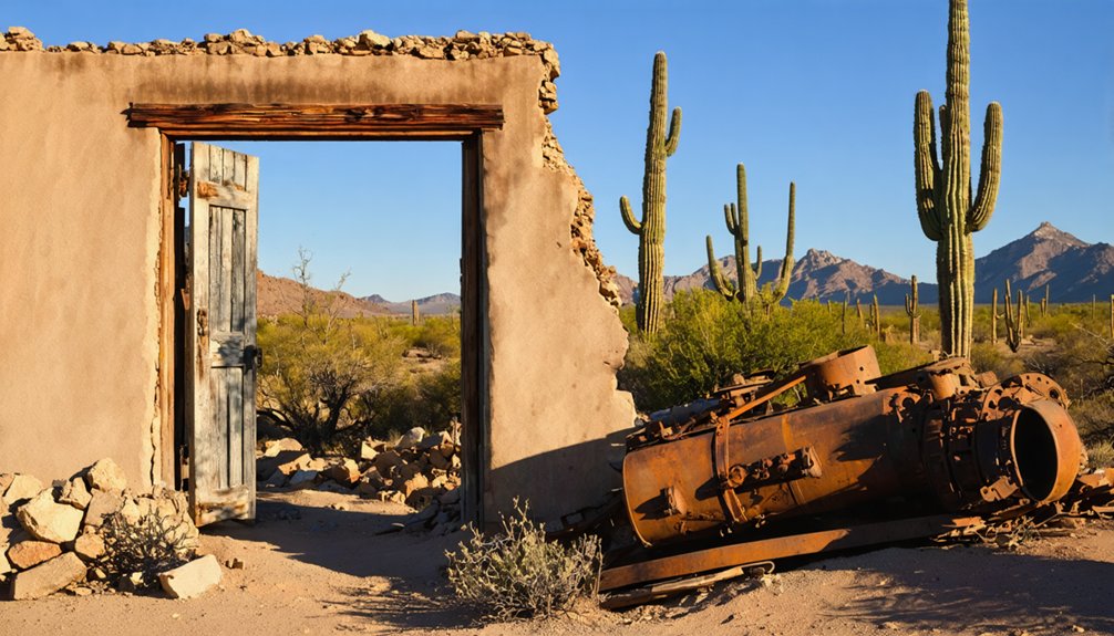
Fairbank and the San Pedro River Valley Communities
While Tombstone’s silver mines captured international attention in the early 1880s, the unassuming settlement of Fairbank quietly established itself as the economic lifeline that kept those distant operations running.
Located along the San Pedro River, this railroad junction transformed from a simple stagecoach stop into a critical transportation hub by 1883.
Fairbank history reveals a community shaped by necessity rather than glamour—three railroad depots moved ore while stagecoaches ferried miners across the final ten miles to Tombstone’s claims.
You’ll find authentic remnants of:
- The 1900 train robbery site where outlaws Burt Alvord and Billy Stiles exchanged gunfire with Wells Fargo guards
- Collapsed structures from the devastating 1890 San Pedro River flood
- Foundation stones marking evicted homesteads after the 1905 land grant dispute
The Bureau of Land Management now preserves what remains. The cemetery sits on a hill approximately 4/10 of a mile from town, containing 30 to 60 graves that mark the final resting places of Fairbank’s residents, most without permanent markers due to families’ financial constraints. The town’s population peaked at about 100 residents by 1886, reflecting its role as a service center rather than a mining boom town.
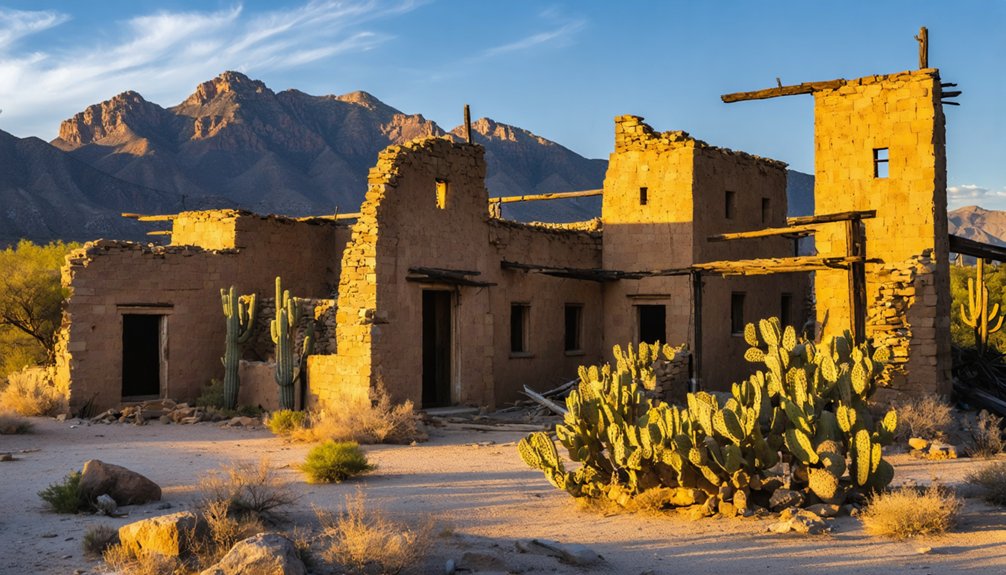
Harshaw: Silver Boom in the Santa Cruz Mountains
About sixty‑five miles south‑southeast of Tucson, you’ll find the scattered remnants of Harshaw, where David Tecumseh Harshaw’s 1877 silver strike triggered a rush that swelled the town to roughly two thousand residents by 1880.
The Hermosa Mining Company‘s twenty‑stamp mill once processed ore from forty‑odd claims that yielded $1.1 million in silver that peak year alone—some of the richest silver‑lead deposits in the territory.
Historic Mining Operations
During the late 1870s, David Tecumseh Harshaw and his partner José Andrade stumbled upon a surface vein of silver near the older Trench mine in the Patagonia Mountains, some 70 miles southeast of Tucson.
You’ll discover that mining techniques evolved rapidly as the Hermosa Mining Company acquired the property, shifting from primitive surface extractions to sophisticated underground shafts and tunnels. By 1880, their stamp mill revolutionized silver extraction, processing ore directly on-site rather than shipping it via mule trains to Guaymas.
The district’s workings reveal the boom’s intensity:
- Multiple lode claims including the Harshaw and Hardshell mines carved into Paleozoic limestones
- Shafts descending to zinc-lead-copper sulphide zones beneath surface silver enrichments
- Fracture-filled copper veins threading through brecciated Cretaceous andesite formations
Remaining Structures Today
Though Harshaw’s population once surpassed 2,000 residents during its silver heyday, you’ll find precious little standing today beyond scattered adobe walls and stone foundations clinging to the hillsides.
The Forest Service systematically demolished remaining structures throughout the 1960s as occupants departed, erasing most evidence of the town’s architectural significance. What survives are accessible adobe ruins along the main street, fireplace foundations marking former homes, and wooden remnants from the mining supervisor’s residence slowly returning to earth.
The scenic hillside cemetery east of town offers the most intact preservation—concrete and stone markers, including one dated 1937, share space with unmarked graves identified only by rock piles.
You’ll notice fresh wreaths, suggesting descendants still honor their mining-era ancestors here where memory persists beyond demolished walls.
Fort Bowie: Military Outpost in Apache Territory
Perched at the narrow defile of Apache Pass, where the Chiricahua and Dos Cabezas Mountains funnel travelers toward the life-sustaining Apache Spring, Fort Bowie emerged from the chaos of battle in 1862.
California Volunteers established this military outpost to protect the Butterfield Overland Mail route and assert U.S. control over Chiricahua homeland.
From crude stone breastworks, the fort evolved into a full garrison with frame buildings, hospitals, and modern infrastructure—serving as operational headquarters throughout the Apache Wars until Geronimo’s 1886 surrender.
What you’ll encounter at Fort Bowie’s ruins:
- Stone foundations marking officers’ quarters and enlisted barracks on the windswept plateau
- The hospital complex where military surgeons treated wounded soldiers and Apache scouts
- Adobe remnants of the original 1862 defensive positions overlooking Apache Spring
Planning Your Visit: Access, Safety, and Preservation Guidelines
Before you load your vehicle with water jugs and topographic maps, understand that visiting Southern Arizona’s ghost towns demands more preparation than a typical weekend outing.
Exploring ghost towns throughout Appalachia offers a glimpse into a bygone era, revealing the remnants of communities once vibrant with life. Make sure to research the history of these locations, as each town has its own unique story to tell. Proper planning will enhance your experience, allowing you to appreciate the beauty and solitude of these abandoned places.
Access routes vary dramatically—you’ll find paved highways to Goldfield’s tourist-friendly Main Street, while Klondyke requires traversing unpaved roads in western Graham County with appropriate vehicle clearance.
Safety considerations extend beyond crumbling buildings at sites like Courtland.
Ghost town exploration presents hazards beyond unstable structures—from wildlife encounters to extreme weather and isolation in remote desert locations.
Charleston and Fairbank near the San Pedro River offer docent-guided visits most days, reducing risks through informed exploration.
Kentucky Camp, forty miles south of Tucson, provides Forest Service-maintained camping facilities.
Swansea’s BLM preservation guarantees structural stability.
Always respect cemetery grounds in Gleeson and Pearce, and remember: those semi-abandoned dwellings you’re photographing? Someone still calls them home.
Frequently Asked Questions
Are Guided Tours Available at Any of the Ghost Towns Near Tucson?
Yes, you’ll find guided experiences at Ruby, Fairbank, and Fort Bowie—roughly 30% of area ghost towns offer organized tours. These guided experiences deliver historical insights through ranger walks and docent talks, revealing mining-era stories you’d otherwise miss exploring solo.
Which Ghost Towns Are Suitable for Families With Young Children?
Tombstone and Fairbank offer the most family-friendly attractions with level terrain, restrooms, and interpretive signs. Bisbee’s mine tours engage older kids, while Gleeson’s roadside jail suits quick stops. Ruby’s remoteness requires supervision during ghost town activities.
Can I Camp Overnight at Ghost Towns Besides Kentucky Camp?
You can camp overnight at Fairbank Historic Townsite with a $2 BLM permit, or Ruby’s private campground with lakes. Both locations maintain camping regulations protecting historic resources while offering distinct ghost town amenities for extended stays.
What Photography Equipment Works Best for Capturing Ghost Town Structures?
You’ll want a high-resolution camera body with weather sealing, an ultra-wide 16–35mm lens for interiors, and a sturdy tripod. Adjust camera settings to ISO 1600–3200 for shadowed rooms; lens recommendations include a fast prime for artifact details.
Are Any Ghost Towns Wheelchair Accessible or ADA Compliant?
Old Tucson offers wheelchair ramps and accessible trails throughout its western film set. True abandoned ghost towns lack ADA compliance—you’ll encounter uneven terrain, narrow doorways, and no accessible infrastructure at remote mining ruins.
References
- https://en.wikipedia.org/wiki/List_of_ghost_towns_in_Arizona
- https://www.arizonahighways.com/article/arizona-ghost-towns
- https://www.visitarizona.com/like-a-local/4-arizona-ghost-towns-you-may-have-never-heard-of
- https://southernarizonaguide.com/ghost-towns-southern-arizona/
- https://www.storelocal.com/blogs/exploring-the-ghost-towns-around-tucson/
- https://www.tripadvisor.com/Attractions-g28924-Activities-c47-t14-Arizona.html
- https://goldfieldghosttown.com
- https://azoffroad.net/kentucky-camp
- https://www.archaeologysouthwest.org/pdf/ait/arch-tuc-v7-no4.pdf
- https://en.wikipedia.org/wiki/Kentucky_Camp


