You’ll find Gilman just fifteen minutes south of Vail—a zinc mining town perched dramatically on cliffs 9,000 feet above the Eagle River. Though you can’t legally enter this EPA Superfund site, designated in 1986 due to heavy-metal contamination, you can photograph the abandoned structures from highway pullouts between Minturn and Red Cliff. For accessible exploration, outfitters like Timberline Tours offer jeep trips to Fulford, a remote gold camp reached via the original 1890s stagecoach road, where you’ll discover the stories behind Eagle County’s boom-and-bust mining heritage.
Key Takeaways
- Gilman, fifteen minutes south of Vail, is a restricted Superfund site viewable only from highway pullouts between Minturn and Red Cliff.
- Fulford Ghost Town, accessible via historic stagecoach routes, features cabins and structures from the 1880s gold mining boom era.
- Guided jeep tours from Vail Valley outfitters provide legal access to Fulford and other backcountry mining sites year-round.
- Late September to early October offers optimal photography conditions with peak aspen colors and accessible roads throughout the region.
- Camp Hale ruins, St. Elmo, and Tin Cup are within ninety minutes, making Vail ideal for exploring multiple ghost towns.
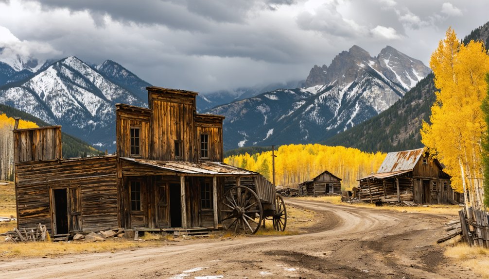
Gilman: Colorado’s Cliffside Mining Town Frozen in Time
Perched on narrow terraced benches hundreds of feet above the Eagle River Canyon, Gilman clings to the mountainside like a relic from another century—which, in many ways, it is.
You’ll find a settlement that thrived from 1879 through 1984, transforming from silver camp to Colorado’s largest zinc producer. The Gilman history began when prospector John Clinton built this company town to house miners working the Battle Mountain district.
From silver rush to zinc empire, Gilman spent a century etched into Colorado’s mountainside before silence reclaimed its streets.
New Jersey Zinc consolidated operations in 1912, creating an underground empire that yielded $328 million in ore by 1972.
The mining legacy left behind isn’t just economic—it’s physical. Contamination earned Gilman Superfund status, and chain-link fences now bar access to its preserved streets, houses, and industrial buildings frozen exactly as workers abandoned them.
Viewing Gilman Safely From Highway Pullouts
While Gilman’s contaminated streets remain strictly off-limits, you can still witness this mountain-clinging ghost town from several designated pull-offs along Highway 24.
Pack binoculars or telephoto lenses—these viewing tips transform distant ruins into detailed explorations of crumbling architecture perched at 8,950 feet above the Eagle River valley.
Between Vail and Leadville, you’ll find broad gravel parking areas positioned for ideal sightlines.
The two-hour drive from Denver delivers frontier history without trespassing risks. Rangers patrol aggressively here, and those vertical mine shafts present legitimate dangers—thousand-foot drops through rotted timbers.
Safety measures matter: stay roadside, use magnification equipment, and respect the boundaries.
Some adventurers deploy drones from legal vantage points, capturing aerial perspectives of Battle Mountain’s clifftop settlement.
Free parking, dramatic vistas, zero permit hassles—liberty-minded exploration done right. The Gilman post office operated for exactly 100 years from 1886 to 1986, marking the town’s full century of continuous occupation before its eventual evacuation. From the highway pullouts, you’ll notice the buildings appear surprisingly modern rather than frontier-style, resembling suburban homes that contrast sharply with typical ghost town expectations.
Understanding Gilman’s EPA Superfund Status and Access Restrictions
You’ll find Gilman’s haunting silhouette perched above Highway 24, but don’t mistake visibility for accessibility—this abandoned mining town was designated an EPA Superfund site in June 1986 due to severe heavy-metal contamination from 8 million tons of mine waste.
The entire 235-acre area remains private property where Eagle County authorities actively prosecute trespassers, making any entry beyond designated highway pullouts both illegal and dangerous.
While cleanup efforts since 1988 have markedly improved Eagle River water quality and removed immediate public health risks from the townsite portion, zinc, cadmium, and copper contamination lingers in soil and groundwater, reinforcing why your exploration must remain strictly visual from authorized roadside vantage points. The Eagle Mine once stood as one of the largest zinc mines in the United States, producing over 12 million tons of ore before operations ceased in December 1977. The town appears in place name disambiguation pages on Wikipedia due to multiple geographic locations sharing the Gilman name.
EPA Designation and Contamination
The toxic legacy of decades-long mining operations caught up with Gilman in 1984 when the EPA ordered the immediate closure of all mining activities due to severe environmental contamination.
You’ll find this 235-acre wasteland holds eight million tons of mine waste, earning its designation on the National Priorities List in June 1986. The environmental impact stemmed from groundwater contamination and flooded Eagle Mine workings.
By 1988, wastewater pumping had devastated the Eagle River ecosystem.
Colorado filed claims against former owners in 1985 under Superfund law. Cleanup efforts concluded in 2000 after extensive remediation, though you can’t visit—it’s strictly off-limits private property.
The site remains a stark reminder of unchecked industrial operations, now standing as testimony to necessary environmental oversight. A water treatment plant constructed in 1990 manages mine seepage, treating approximately 140 million gallons annually. Despite its abandonment, the town continues to suffer from vandalism and decay, with broken windows and graffiti marking the structures that remain frozen in time since 1984.
Legal Viewing Access Points
Because Gilman sits entirely on private property with active trespassing enforcement, your only legal access for viewing this clifftop ghost town is from designated pullouts along U.S. Highway 24 between Minturn and Red Cliff.
Multiple roadside turnouts offer clear line-of-sight to the abandoned houses and mine buildings perched above the Eagle River—all without leaving the highway right-of-way.
Viewing restrictions to respect:
- Remain within highway pullouts; climbing toward the townsite triggers prosecution
- Superfund status requires institutional controls prohibiting recreational entry
- No Trespassing signage posted along all approach routes
- Active patrols monitor for unauthorized access attempts
- Liability concerns mean no informal permission granted
Highway 24 stays open year-round for standard vehicles, letting you photograph from a distance while authorities enforce the off-limits boundary. The site includes remnants of a school, boarding house, and offices that once served the mining community active until 1984. Timberline Tours’ Camp Hale and McAllister Gulch jeep tours frequently pass viewpoints where guests can safely observe Gilman from approved locations.
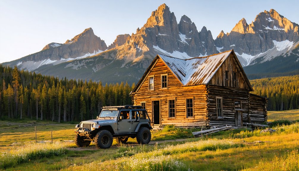
Fulford: A Remote Gold Camp in the Eagle County Backcountry
You’ll find Fulford tucked deep in the Eagle County backcountry, accessible today along the same historic stagecoach route that once ferried supplies and hopeful miners up from Eagle starting in the 1890s.
The camp exploded after gold discoveries near Nolan Creek in 1891–1893, swelling to several hundred residents who built a complete townsite of cabins, boarding houses, and saloons across upper and lower sections.
Historic Stagecoach Road Access
Linking Eagle’s Denver & Rio Grande railhead to the high-elevation gold camp fifteen miles distant, the stagecoach road to Fulford functioned as the mining district’s economic lifeline throughout the 1890s boom.
You’d recognize the route challenges immediately: switchbacks carved into timbered slopes, creek crossings that swelled dangerously during spring runoff, and stretches prone to avalanches and rockfall.
The stagecoach significance became clear when winter snows closed the upper segments, isolating Fulford’s residents for weeks and choking mine resupply.
Key operational realities:
- Passengers, U.S. mail, and express freight traveled several hours between terminals
- Outbound ore samples and inbound blasting powder shared wagon space
- Deep ruts and washouts made spring travel treacherous
- Winter sleighs replaced wheeled stages during heavy snowpack
- Seasonal closures directly impacted underground mining continuity
Gold Rush Boom and Decline
Gold struck the quartzite cliffs of Battle Mountain in 1884 when A.H. Fulford made his discovery, transforming this remote backcountry into a bustling camp.
By spring 1886, the settlement reached peak prosperity as prospectors and investors flooded in, attracted by gold mining opportunities that revitalized the region’s economy. The Leadville Herald Democrat documented Fulford’s achievements, chronicling the camp’s explosive growth.
Tragedy struck when Fulford died in a snow slide just six months after his discovery, yet the camp bearing his name continued thriving.
However, the boom proved short-lived. As veins played out and easier claims were exhausted, miners abandoned their operations.
Today, Fulford stands as a ghost town monument to Colorado’s volatile mining era, where fortune and ruin arrived with equal swiftness.
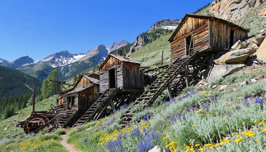
Jeep Tours to Ghost Towns Departing From Vail Valley
Several outfitters operating from the Vail Valley have built their reputations guiding visitors deep into Eagle County’s mining backcountry, where rusted headframes and weathered cabins mark the sites of communities that thrived and died with the silver strikes of the 1880s.
Rusted headframes and weathered cabins still mark where silver boom communities thrived and vanished in the 1880s.
You’ll find jeep tour experiences ranging from half-day excursions to full interpretive journeys, each following scenic routes through alpine terrain that passenger cars can’t access.
- Timberline Tours runs dedicated Fulford Ghost Town trips via the old stagecoach road, accessible by June.
- Nova Guides offers 3-hour backcountry tours climbing to 12,500 feet through aspen groves and historic trails.
- Camp Hale routes pass Gilman’s abandoned site while covering 10th Mountain Division history.
- Above & Beyond 4×4 Guides departs from Wolcott’s Eagle River valley.
- Fall aspen color draws crowds to McAllister Gulch and Highway 24 corridor tours.
Best Seasons for Ghost Town Photography Near Vail
Once you’ve chosen your tour and seen these weathered sites firsthand, you’ll likely want to return with a camera to capture them properly—and timing that return makes all the difference.
Late September through early October delivers peak aspen color around ghost-town structures along Highway 24, with best photo techniques leveraging golden-hour backlight through yellow foliage.
Summer access opens remote sites by late June, offering wildflower foregrounds and dramatic thunderstorm skies.
Winter snow creates high-contrast monochrome scenes, though seasonal gear must include traction devices and insulated layers.
Spring’s patchy snowmelt provides dynamic shifting landscapes with fewer crowds.
Each season demands different approaches: autumn rewards wide landscape compositions, summer allows multi-location coverage in extended daylight, and winter’s low sun emphasizes structural texture through elongated shadows.
The Mining Boom-and-Bust Story of Eagle County
- 1884: Fulford’s discovery of high-grade free-milling gold doubled Battle Mountain’s output
- 1886: Iron Mask Mine shipped 100+ tons daily via tramway
- 1887: Railroad arrival transformed Minturn into booming service center
- 1918–1920s: Consolidation created the massive Eagle Mine
- 1954: Zinc revenue alone hit $32,822,268
Planning Day Trips to Other Colorado Ghost Towns From Vail
Eagle County’s boom-and-bust legacy provides just a glimpse of Colorado’s vast ghost town network, and Vail’s central mountain location makes it an ideal launching point for exploring dozens of abandoned settlements scattered across neighboring valleys and high passes.
Vail’s mountain crossroads position unlocks access to countless forgotten mining camps tucked throughout Colorado’s backcountry passes and alpine valleys.
You’ll find Gilman just fifteen minutes south—perfect for quick ghost town photography from highway pullouts. Extend your radius and Camp Hale’s ruins await under ninety minutes round-trip.
For full-day scenic drives, tackle the Independence Pass loop through Leadville, Twin Lakes, and Independence ghost town before descending into Aspen.
St. Elmo and Tin Cup near Buena Vista reward adventurous souls with intact storefronts and rowdy cemetery headstones.
Summer opens high-country routes; winter shifts focus to lower elevations like Gilman and Camp Hale, keeping your exploration calendar full year-round.
Frequently Asked Questions
Are There Any Lodging or Camping Options Near Gilman Ghost Town?
You won’t find camping amenities directly at Gilman—it’s private property on a dangerous hillside. Based on archival research into Gilman history, you’ll need to stay in Vail, about thirty minutes away, where lodging options abound.
Can You Explore Ghost Towns Near Vail With Children Safely?
You can safely explore with children using proper safety precautions—stick to roadside viewpoints and permitted jeep tours rather than entering unstable structures. Child friendly activities include guided heritage stops at controlled distances from hazardous mine sites.
What Equipment Do I Need for Winter Ghost Town Visits?
You’ll need insulated waterproof boots, microspikes for icy trails, layered winter gear including puffy jackets, and essential safety tips like carrying headlamps for short daylight hours. Don’t forget gaiters and emergency supplies when exploring abandoned sites.
Are There Guided Walking Tours of Fulford’s Historic Buildings?
You won’t find guided tours practically anywhere in Fulford—the townsite’s privately owned cabins and rugged terrain make organized walks impossible. Instead, you’ll experience its historical significance through self-guided exploration and archival research before visiting.
How Long Does a Typical Ghost Town Day Trip Take?
You’ll spend 4–8 hours total on a typical ghost town day trip from Vail. Travel time to nearby sites like Gilman runs 15–25 minutes, while distant destinations require several hours of scenic mountain driving and exploration.
References
- https://www.colorado.com/articles/colorado-ghost-towns
- https://www.uncovercolorado.com/ghost-towns/gilman/
- https://timberlinetours.com/colorado-ghost-towns/
- https://www.uncovercolorado.com/ghost-towns/
- https://www.vailmag.com/news-and-profiles/2019/10/a-look-back-at-gilman
- https://en.wikipedia.org/wiki/Gilman
- https://vail.marmot.org/Archive/evld:7202/Book
- https://www.legendsofamerica.com/gilman-colorado/
- https://westernmininghistory.com/towns/colorado/gilman/
- https://www.mininghistoryassociation.org/Journal/MHJ-v22-2015-Brill.pdf


