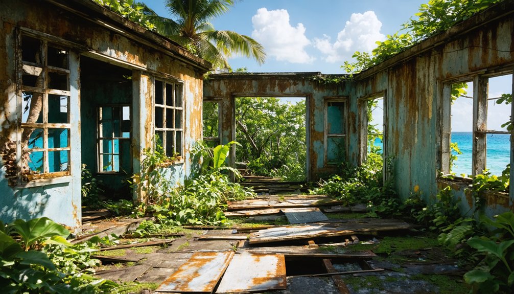
You’ll find St. John’s “ghost towns” aren’t Wild West settlements—they’re Danish colonial sugar plantation ruins dating from 1717 to the 1848 emancipation. Annaberg and Cinnamon Bay plantations showcase windmill towers, factory walls, and enslaved workers’ quarters accessible via marked trails, while dozens of hidden estates like Catherineberg and Reef Bay lie deeper in the forest. These sites preserve the architecture and social history of coerced labor communities that once cultivated 1,300 acres before resistance, revolt, and economic collapse transformed them into stone foundations slowly reclaimed by tropical vegetation. The full story reveals how these ruins connect to broader American settlement patterns.
Key Takeaways
- Annaberg Sugar Plantation (est. 1721) features accessible ruins including a windmill tower, sugar factory, and enslaved peoples’ quarters near the parking lot.
- Cinnamon Bay Plantation ruins from 1717 include factory walls, boiling house remnants, and a Danish cemetery accessible via a half-mile loop trail.
- Hidden estate ruins at Catherineberg, America Hill, and Susannaberg lie scattered in St. John’s interior, some requiring bushwhacking to access.
- Reef Bay Estate features an 1844 Great House and 1862 steam-powered sugar mill with cast-iron engine still anchored in place.
- Virgin Islands National Park has catalogued over 100 historic plantation sites, with ranger-guided tours and interpretive signs documenting their history.
Annaberg Sugar Plantation Ruins: St. John’s Most Iconic Abandoned Settlement
The windmill tower rising above Leinster Bay stands as the most recognizable remnant of Annaberg Sugar Plantation, established in 1721 under Danish planter Christopher William Gottschalk on land he named for his daughter Anna.
Annaberg history traces ownership through Danish, French, Dutch, and Irish elites who extracted wealth from 662 enslaved people forced to labor across 1,300 acres at the plantation’s peak. Frederick Moth, who served as the first Danish Governor of St. Croix, owned the plantation during the 1720s and 1730s before it expanded into one of St. John’s largest sugar producers.
The plantation’s prosperity rested entirely on the forced labor of 662 enslaved people who worked its 1,300 acres.
You’ll find the integrated sugar production complex—windmill, horse mill, boiling house—where crushed cane juice flowed at 300-500 gallons per hour into copper kettles that concentrated it into raw sugar, molasses, and rum for Atlantic export. The windmill stands 38 feet high with walls of coral stone and ballast brick that powered rollers crushing sugarcane when trade winds swept across the hillside.
The 1733 slave revolt damaged these works, and after 1848 emancipation, the machinery fell silent, leaving stone ruins that testify to resistance against exploitation.
Cinnamon Bay Plantation Ruins: A Tropical Ghost Town Landscape
Established in 1717 on St. John’s north shore, Cinnamon Bay plantation evolved from a Danish sugar estate into one of the island’s most evocative ruined landscapes.
You’ll find the complex clustered 100–150 meters inland from the beach, where factory walls, boiling house remnants, cistern foundations, and an intact Danish cemetery create a dense ghost town atmosphere beneath tropical canopy.
Enslaved Africans once labored here cutting cane and processing molasses until the 1733 rebellion disrupted colonial order. By 1913, cattle replaced sugar entirely.
Today, the half-mile Cinnamon Bay Loop Trail threads through these silent structures within Virgin Islands National Park. Discolored masonry, overgrown terraces, and interpretive gaps between scattered signs preserve an authentically abandoned plantation atmosphere—offering you unmediated encounter with St. John’s layered history of exploitation, resistance, and transformation. The National Park Service has worked alongside local and international organizations to stabilize the ruins against erosion and tropical weather. Successful preservation efforts at Cinnamon Bay have included collaboration with The Friends of the VINP and volunteers to maintain the site’s historical integrity.
Hidden Estate Ruins Scattered Across St. John’s Interior
Beyond the coastal sugar works, you’ll find St. John’s interior hillsides still harbor dozens of estate ruins slowly disappearing beneath secondary forest—windmill towers rising from vine-choked clearings, stone cisterns plugged with leaf litter, and terrace walls threading invisibly through mahogany and genip groves.
Sites like Catherineberg, America Hill, and Susannaberg represent a second tier of plantation infrastructure deliberately sited inland for wind exposure, water catchment, and surveillance over enslaved labor in surrounding cane fields.
These hidden complexes now exist in varying states of interpretation: some marked by National Park signage, others accessible only by bushwhacking through dense vegetation that’s reclaimed masonry foundations laid two centuries ago. The America Hill estate, reached via five switchbacks from the main trail, exemplifies late nineteenth-century Virgin Island architecture and allegedly served as rum-runner headquarters during Prohibition. The Reef Bay Estate Great House, completed in 1844, stands boarded and deteriorating along the trail to Lameshur, its fallen stone columns marking dates while small trees sprout from within its walls.
Forest-Swallowed Mill Foundations
Beneath St. John’s dense canopy, you’ll discover sugar mill foundations that mark the island’s colonial past.
These coral-block and lime-mortar ruins—scattered along Centerline Road and Reef Bay Valley—form an agro-industrial ghost landscape now reclaimed by tropical forest.
Reef Bay Sugar Mill showcases exceptional mill architecture through its 1862 cast-iron steam engine still anchored to original foundations.
Stone platforms reveal where horse-powered machinery once crushed cane, illustrating the historical significance of changing from animal to steam power.
Catherineberg’s windmill tower commands a hilltop, surrounded by factory walls built from reef-quarried coral.
The complex preserves cookhouses, warehouses, and slave quarters—a complete 18th-century production core.
These enduring foundations offer you direct evidence of plantation operations, their masonry outlasting wooden superstructures lost to hurricanes and time.
Overgrown Terraces and Cisterns
Radiating uphill from these mill complexes, stone terraces climb St. John’s interior slopes—stepped agricultural platforms that once anchored sugarcane and provision grounds across 18th and 19th-century estates.
You’ll find this terrace agriculture largely hidden now within secondary dry forest at Catherineberg, Reef Bay, and neighboring plantations, the coral-block walls buried under leaf litter and root systems.
These benches weren’t merely crop space; they formed integrated water management networks, slowing runoff and directing rainfall toward massive masonry cisterns that still dominate estate footprints.
Catherineberg’s enormous cistern and Reef Bay’s semi-circular concrete reservoir stand as the period’s essential infrastructure—capturing roof runoff through dry seasons when streams failed.
The windmill, still, factory, horse mill, and stable at Catherineberg represent the documented architectural range of 18th-century sugar production facilities that once processed cane harvested from these terraced slopes.
At Catherineberg, the well-preserved windmill base rises almost four stories tall, marking it as one of the site’s most prominent remaining structures.
Brush obscures most outlying features today, leaving you alone among fragments of circulation routes that once tied great houses, cookhouses, and terraced fields into working plantation landscapes.
From Thriving Communities to Silent Ruins: The Social History Behind the Ghost Sites
Long before windmill towers crumbled into jungle or boiling houses stood roofless under Caribbean sun, the sites you encounter as “ruins” in Virgin Islands National Park thrived as layered human landscapes—first as Indigenous villages where Taino families fished the bays and tended manioc gardens, then as coerced plantation communities where hundreds of enslaved Africans cut cane, tended fires, and forged kinship under brutal labor regimes.
This Indigenous Legacy stretches back 3,000 years to Cinnamon Bay and Lameshur, where maritime societies predated European contact by millennia.
After 1718, Danish colonizers transformed these same sheltered coves into sugar factories.
Plantation Memories embedded in Annaberg’s 662 enslaved residents and the 1733 rebellion reveal communities who resisted, escaped to maroon camps, and ultimately outlasted their oppressors.
You’re walking through centuries of survival, not mere decay.
Exploring the Ruins: Access, Trails, and What to Expect

You’ll find Annaberg Plantation’s ruins just steps from the parking lot, making it the most accessible historic site in Virgin Islands National Park where you can examine enslaved peoples’ quarters, the sugar factory, and the windmill without significant hiking.
For a more immersive experience, follow the half-mile Cinnamon Bay Loop Trail through Danish colonial ruins, where the Estate House foundations and structures from the Josie Gut Sugar Estate—including the boiling room and horsemill—remain visible against the backdrop of a 40-foot waterfall.
Both sites offer ranger-guided tours that contextualize the physical remains within the broader history of Caribbean plantation economies.
Annaberg Trail and Wayside
Twenty minutes northeast of Cruz Bay, the North Shore Road dead-ends at a small parking lot serving both the Annaberg Sugar Plantation ruins and the rocky shoreline trail to Leinster Bay.
The interpretive walking trail loops through one of St. John’s largest Danish colonial estates, active during the early 19th century peak of plantation agriculture. Wayside exhibits and labeled ruins explain the brutal mechanics of sugar production—windmill power, boiling houses, and rum distillation—all built on the violent displacement of Indigenous peoples and the forced labor of enslaved Africans.
Annaberg history unfolds along relatively flat paths among crumbling walls and cisterns, though the initial descent from parking remains steep and rocky. Most visitors spend thirty to sixty minutes absorbing the documentation of this colonial enterprise before continuing toward Waterlemon Cay.
Cinnamon Bay Access Points
A half-mile loop trail weaves through the Danish colonial sugar plantation ruins at Cinnamon Bay, accessible from Highway 10 at mile-marker 4, roughly 15 minutes northeast of Cruz Bay.
You’ll find limited parking at the entrance, where multiple access points connect the historical site to the beachfront below.
The self-guided trail reveals 1700s-era remnants including windmills, slave quarters, and sugar processing machinery.
Interpretive signs document the plantation’s operational history throughout the shaded, rocky ascent.
Primary Cinnamon Bay Access Points:
- Highway 10 trailhead (50 feet past mile-marker 4)
- Beach-level entrance requiring minimal walking distance
- Connected pathways from Cinnamon Bay Beach recreational area
This Virgin Islands National Park protected site accommodates most fitness levels, though rocky inclines demand proper footwear.
Family crypts and fire kilns punctuate the ruins against Caribbean Sea vistas.
How Virgin Islands National Park Preserves These Forgotten Settlements
Through systematic archaeological surveys and GIS mapping, Virgin Islands National Park has catalogued more than 100 historic plantation sites, maroon communities, and worker villages that dot its 7,200 acres of protected land and water.
You’ll find rangers conducting structural stabilization at ruins like Cinnamon Bay Sugar Plantation, where post-Hurricane Irma conservation teams have repaired Danish-era masonry using Secretary of the Interior’s preservation standards.
The park’s cultural preservation approach emphasizes the archaeological significance of enslaved and Indigenous communities—not just colonial architecture.
Vegetation control prevents tree roots from destroying walls and factory remains, while interpretive panels along the Reef Bay Trail connect you to narratives of resistance and survival.
Federal protection laws guarantee these ghost settlements remain accessible witnesses to difficult histories rather than erased landscapes.
St. John’s Plantation Ruins in the Context of America’s Ghost Town Heritage

Why should plantation ruins on a Caribbean island qualify as American ghost towns?
You’ll find St. John’s estates embody the same boom-and-bust cycles that created abandoned mining camps across the continental West. Annaberg, Reef Bay, and Catherineberg operated as self-contained agro-industrial complexes—vertically integrated company towns concentrating land, labor, and processing infrastructure.
These sites preserve three defining American narratives:
- Plantation economics mirroring single-industry settlements that collapsed when global markets shifted
- Enslaved resistance, including the 1733 revolt and escape routes linking to the Underground Railroad Network
- Industrial architecture—windmills, boiling houses, terraced hillsides—documenting coerced labor systems critical to understanding abandoned American settlements
You’re witnessing tropical ghost landscapes where regenerated forest conceals once-dominant economic centers, their silence speaking to both exploitation and liberation.
Frequently Asked Questions
Are There Any Ghost Towns on St. Thomas or St. Croix?
No official ghost towns exist on St. Thomas or St. Croix. You’ll find ruined plantation estates and haunted colonial sites with historical significance instead—Fort Christian and Frenchtown ruins preserve cultural heritage through spectral folklore and architectural remnants.
In exploring the remnants of history, consider the allure of abandoned towns from the gold rush that dot the American West. These locations offer a glimpse into a time of fervor and fortune, where dreams were built and then left to decay. Visitors can wander through the echoes of a bygone era, discovering stories etched in the crumbling facades and dusty streets.
Can Visitors Enter the Buildings at Plantation Ruins?
You’ll find varying access to plantation architecture across St. John’s ruins. Catherineberg welcomes you inside preserved Danish colonial buildings, while Annaberg’s sugar mill remains closed. Each site offers unique perspectives on their historical significance through accessible structures.
What Happened to Descendants of Enslaved People After Emancipation?
Documentation gaps limit knowledge of descendants’ experiences, though you’ll find post-emancipation challenges included land access restrictions and economic marginalization. Cultural heritage preservation efforts today honor their resilience despite archival silences about freedom’s immediate aftermath.
Are There Guided Tours Available for Plantation Ruins?
Like Virgil guiding travelers through history’s shadows, you’ll find guided tour options at Annaberg Plantation through park docents and tour operators who illuminate plantation history. Self-guided interpretive trails with information plaques let you explore freedom’s contested landscape independently.
How Do Hurricanes Affect Preservation of the Ruins?
Hurricane impact poses severe preservation challenges you’ll witness firsthand—storm surges erode foundations, wind strips protective vegetation, and flooding accelerates structural decay. Without immediate post-storm intervention, these historical sites face irreversible deterioration threatening cultural heritage.
References
- https://mosthauntedplacesintheworld.com/most-haunted-places-in-the-u-s-virgin-islands/
- https://stgeorgevacationrentals.com/blog/st-george-attractions-grafton-ghost-town/
- https://www.visitutah.com/things-to-do/history-culture/ghost-towns
- https://www.atlasobscura.com/places/grafton-ghost-town
- https://www.smithsonianmag.com/travel/abandoned-settlements-hidden-inside-national-parks-180955064/
- https://wbkr.com/historic-mountain-ghost-town-awaits-your-next-east-tn-visit/
- https://www.scoutingny.com/abandoned-in-the-caribbean-the-ruins-and-beauty-of-st-john/
- https://www.vighosttours.com/post/3-haunted-places-to-visit-in-the-us-virgin-islands-on-a-ghost-tour
- https://www.youtube.com/watch?v=RSS454PKQWM
- https://saintjohnislandguide.com/listing/annaberg-ruins-trail/


