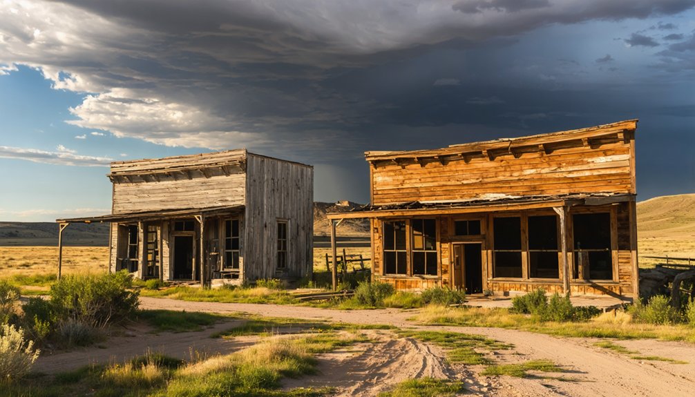
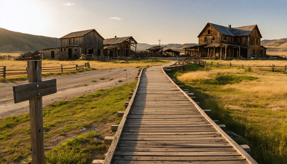
You’ll find several authentic ghost towns within an hour of Wind Cave National Park, remnants of the Black Hills Gold Rush (1874-1876) and subsequent mining booms. Rockerville, 30 miles north, preserves buildings from its 1877 gold strike, while Spokane operated until 1940 as a multi-metal hub. Etta, near Keystone, once housed America’s largest spodumene mine before closing in 1959. Maitland (Garden City) and Galena offer scattered foundations along backcountry routes. Some settlements now rest beneath Pactola Reservoir’s waters, their concrete foundations visible during low water. Each site reveals distinct chapters of hard-rock mining economics and frontier adaptation.
Key Takeaways
- Maitland (Garden City) lies near Wind Cave, founded 1876–1877 for gold mining, with 1–2 structures and foundations remaining after 1941 abandonment.
- Rockerville, established after 1877 gold discovery, produced $150,000 its first season and retains historic structures and flume remnants today.
- Galena in Vanocker Canyon briefly flourished in the 1870s before declining; a historic schoolhouse survives among scattered settlement remnants.
- Access via US-385 and SD-44 requires caution due to open mine shafts, unstable structures, and potential private land trespassing issues.
- Pactola townsite was condemned and submerged in 1956 beneath Pactola Reservoir, with underwater foundations and structures still visible.
Black Hills Mining Heritage and the Ghost Town Legacy
When the Black Hills Gold Rush exploded between 1874 and 1876, hard-rock claims quickly replaced the early placer camps that had lined gulches and creekbeds, setting in motion a boom-bust cycle that would scatter ghost towns across the region for decades.
Underground operations around Lead, Deadwood, and Bald Mountain created dense belts of company towns—instant settlements with boarding houses, salaries, and stamp mills clustered around individual mines.
You’ll find the evidence today: abandoned shafts, eroded tailings, and cyanide vats at Hornblend, Blue Lead, Flatiron, and Galena mark where mining techniques evolved from simple extraction to industrial-scale processing.
The economic impacts were severe—once ore played out or capital withdrew, entire communities vanished, leaving only foundations and mine waste “badlands” as proof of hard-rock extraction’s volatile legacy.
Spokane: Multi-Metal Mining Hub Along the Highway Corridor
Unlike the single-commodity placer camps that flickered out when creek gravels ran dry, Spokane evolved into a rare multi-metal operation that adapted and endured for half a century.
Established in 1890 after the Judd family discovered lead-silver veins in Custer County, the camp thrived by pivoting between profitable ores as markets shifted—embodying a multi metal strategy that kept mines running through 1940.
Spokane’s fifty-year survival stemmed from strategic flexibility—shifting between lead, silver, and other metals as economic conditions demanded.
Peak production in 1927 generated roughly $150,000 annually from:
- Gold and silver extracted from primary veins
- Industrial minerals including mica, graphite, and beryl from pegmatites
- Base metals (lead, zinc, copper) processed at on-site mills
The mine’s closure in 1940 triggered the town’s rapid abandonment as miners and their families departed for opportunities in more prosperous Black Hills communities.
Today you’ll find Spokane’s remnants just off Forest Service roads near US-385, where Spokane heritage merges with the scenic corridor linking Wind Cave and Custer State Park. The schoolhouse stands among the most intact structures, featuring three rooms with distinctive lime green walls and debris-covered stairs.
Rockerville: Gold Rush Relic Between Keystone and Rapid City
While most Black Hills placer camps sputtered out within months, Rockerville commanded the region’s attention for nearly three years after prospectors struck gold in Rockerville Gulch in 1877.
You’ll find this “banner placer district” produced $150,000 in its first season alone—more than all other Black Hills camps combined by 1878. The town’s wooden “rockers” separated gold from gravel until chronic water scarcity forced construction of the ambitious Rockerville Flume, carrying water twenty miles from Spring Creek until 1885.
Today’s mostly-ghost-town sits along Highway 16 between Keystone and Rapid City, where historic structures and visible flume remnants mark the shift from thriving gold mining hub to roadside relic. The settlement received its post office in 1879, two years after the initial gold discovery brought hundreds of fortune seekers to the gulch. A broad quartz lode running southwest to northeast attracted hard rock miners beyond the placer operations that initially defined the camp.
The Flume Trail still follows the original route through scattered artifacts.
Etta: Tin and Lithium Ore Camp Outside Keystone
- Reinbold & Company extracted 1,200 tons between 1899–1900.
- Etta became America’s largest spodumene producer.
- The mine yielded the world’s largest known spodumene crystal.
- Spodumene crystals here commonly reached 3-4 feet in diameter and stretched 30 feet long.
Operations continued intermittently until 1968.
The town became deserted after the mine’s final closure in 1959.
Today you’ll find a dramatic open pit with steep rock walls and a lake—visible from nearby roads, though you’ll need landowner permission to explore this private-land ghost.
Galena: Vanocker Canyon Settlement and Historic Schoolhouse
Galena emerged in Vanocker Canyon during the 1870s as prospectors discovered promising gold deposits in the rugged gulches northeast of present-day Hill City.
You’ll find remnants of this settlement scattered throughout the canyon, where miners once carved their fortunes from unforgiving terrain. The camp flourished briefly before declining as richer strikes drew fortune-seekers elsewhere.
Today, you can explore Vanocker Canyon’s most enduring landmark—a historic schoolhouse that served the mining families who refused to abandon their claims.
The weathered schoolhouse in Vanocker Canyon remains as a testament to the mining families who stubbornly clung to their dreams.
This weathered structure stands as evidence of the community’s determination to establish roots despite harsh conditions. The building’s hand-hewn logs and primitive construction reveal the settlers’ resourcefulness.
Though Galena never achieved the prominence of neighboring camps, its story reflects the broader Black Hills experience: ambitious dreams, backbreaking labor, and communities that vanished as quickly as they appeared. The settlement’s name echoes that of the Illinois mining town where lead mines existed before 1810, worked by Native Americans along the Galena River. Illinois Galena thrived while Chicago remained a swamp village during its economic peak in the 1840s.
Pactola and Sheridan: Towns Lost Beneath Reservoir Waters
When you explore the Black Hills today, you’ll find Pactola Reservoir concealing one of the region’s earliest mining camps—the town of Pactola (Camp Crook), founded around 1875 as a placer mining settlement that once housed over 300 residents.
The U.S. Army Corps of Engineers constructed Pactola Dam between 1952 and 1956 under the Pick-Sloan Missouri Basin Program, deliberately flooding the valley to create a municipal water supply for Rapid City and provide flood control.
Beneath the reservoir’s surface, building foundations and a CCC dynamite bunker remain from the pre-inundation town, though most structures were auctioned and relocated before the waters rose.
Pre-Reservoir Mining History
As prospectors pushed northward from disappointing diggings at Custer in the mid-1870s, they established a sequence of placer camps along the drainage systems of the central Black Hills—Hill City, Sheridan, and Pactola among them.
These settlements thrived briefly on placer mining, with Pactola named for the ancient Lydian river famous for golden sands.
The mining landscape centered on three activities:
- Panning and sluicing alluvial gravels in Rapid Creek and Spring Creek drainages
- Small-scale hard-rock workings scattered throughout surrounding hills
- Freight and supply operations connecting isolated camps to emerging regional centers
Yet modest gold yields couldn’t compete with Deadwood and Lead’s bonanzas.
Sheridan briefly held county-seat status, but relative isolation and limited ore bodies triggered economic decline.
You’ll find these towns represented only persistent frontier optimism—before reservoir waters claimed them entirely.
Reservoir Construction Timeline
By the late 1930s, Rapid City’s expanding population and agricultural development in the Rapid Valley had outpaced existing water infrastructure, prompting the Bureau of Reclamation to survey potential dam sites along Rapid Creek.
They selected the final location on November 14, 1939, incorporating it into the Pick–Sloan Missouri Basin Program. Construction began November 25, 1952, employing up to 200 workers who moved 4,319,993 cubic yards of earthfill and rockfill over nearly four years.
The reservoir impacts became unavoidable: federal authorities condemned the 1870s-era townsite of Pactola, prohibited new construction below elevation 4,621.5 feet, and auctioned most buildings for relocation.
Community displacement unfolded as crews clear-cut vegetation and salvaged the rail line before the dam closed August 15, 1956, leaving remnants of Pennington County’s earliest settlements beneath the rising waters.
Underwater Remains Today
- A reinforced CCC dynamite bunker from the 1930s—one of few clearly identifiable structures.
- Rotting cabin remnants and concrete foundations colonized by algae.
- Cellar holes and building outlines buried under decades of silt.
The lake’s relatively clear water aids visibility during favorable conditions.
Though historical preservation exists only in skeletal form underwater, one original cabin survived downstream, offering you a tangible reference to Pactola’s architectural past.
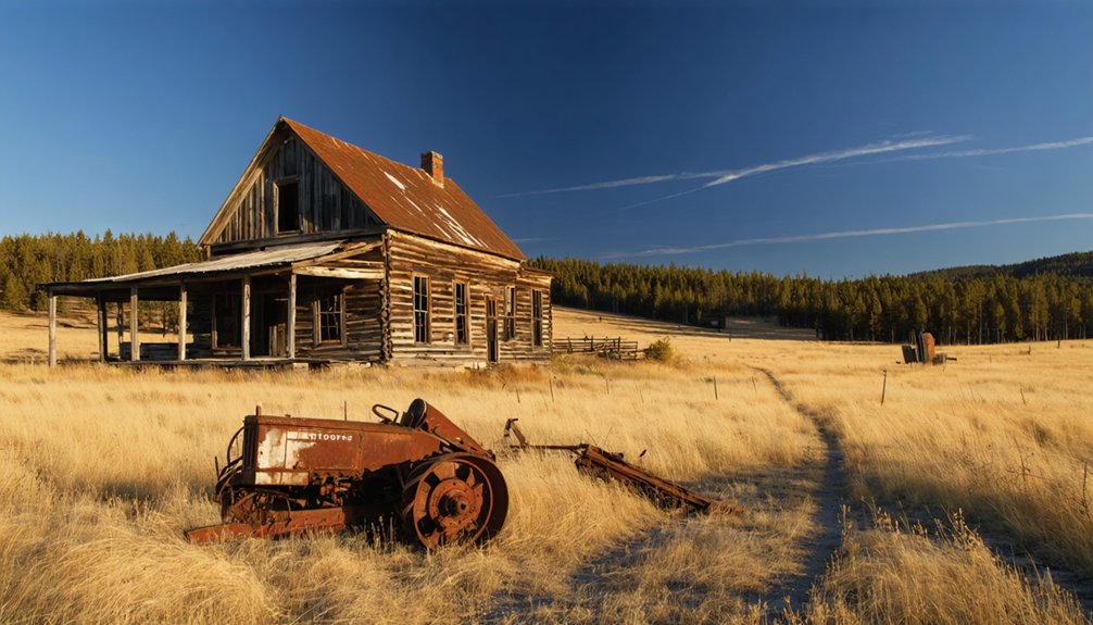
Maitland (Garden City): Scattered Remnants Near Deadwood
Founded as Garden City during the frenetic 1876–1877 Black Hills Gold Rush, this settlement emerged in the Deadwood–Two Bit mining district as one of the original camps serving hard-rock gold operations along False Bottom Creek.
At its peak, roughly 50 buildings stood here, complete with telephone service and electricity—uncommon luxuries for a remote mining town.
When Alexander Maitland took control of the Penobscot Mine in 1902, he renamed the camp and installed a 40-ton stamp mill.
Maitland history reveals intermittent operations until 1915, followed by official abandonment in 1941. The mill burned during dismantling in 1950.
Today, mining remnants dot the landscape 2.5 miles northwest of Central City.
You’ll find 1–2 standing structures, scattered foundations, and rusting equipment—tangible evidence of an industry that once defined these hills.
Prairie Ghost Towns: Ardmore, Okaton, and Southern Settlements
While gold-bearing hills around Deadwood drew fortune-seekers with promise of mineral wealth, the windswept prairie southeast of Wind Cave tells a different story—one of railroads, experimental agriculture, and the harsh realities of water scarcity on the High Plains.
Ardmore history unfolds along Highway 71 near the Nebraska border, where steam locomotives once stopped for Hat Creek’s acidic water. The town’s 1911 experimental farm tested dry farming techniques that drew President Coolidge in 1927, but chronic drought doomed both crops and community.
Dieselization eliminated water stops entirely.
Today you’ll find Ardmore’s remnants:
- White experimental barn visible from Hot Springs approach
- 15–25 abandoned houses and deteriorating water tower
- Boarded general store along Burlington Northern Santa Fe tracks
Population: one resident in 2020.
Boom-and-Bust Cycles: Mining Economics and Transportation Shifts
Gold’s discovery after Custer’s 1874 expedition set off a speculative frenzy that shaped—and ultimately unmade—dozens of mining camps across the southern Black Hills.
You’ll find that mining economics drove every settlement decision: ore at Maitland fetched $30 per ton, yet extraction and milling costs strangled profits. Cyanide plants and stamp mills demanded constant ore flow to justify their fixed capital—when grades declined or key facilities burned, reinvestment evaporated.
Transportation shifts sealed many fates. Rail spurs determined which camps could ship ore economically; Cambria thrived on its Burlington spur until coal demand collapsed.
When the Bald Mountain Mine closed in 1959, Trojan emptied overnight. Fluctuating gold prices, rising labor costs, and resource depletion triggered repeated busts, leaving you with seasonal cabins where prospectors once chased fortunes.
Visiting Ghost Towns: Access Routes, Safety, and Preservation
You’ll approach most Black Hills ghost towns via US-385 and SD-44, with paved routes serving Deadwood and Rochford before gravel spurs branch toward smaller sites like Maitland and Galena.
As you explore more of the region, consider taking a detour to historic ghost towns near San Antonio, where remnants of the past await discovery. Each town tells a unique story of its former residents, from booming mining communities to places left behind in time. Capture the haunting beauty of abandoned structures and the fascinating history that surrounds them.
Once on-site, open mine shafts, unstable adits, and collapsing timber frameworks pose serious injury risks that demand you stay clear of all underground workings and deteriorating structures.
Because many sites occupy patented mining claims or private ranch land rather than public forest, you must verify legal access before crossing fences or walking through tailings fields.
Main Approach Highways
Two primary highways provide access to the ghost town sites scattered throughout the Black Hills region surrounding Wind Cave National Park.
US Highway 385 serves as the main access corridor, running north-south through the heart of historic mining territory. State Highway 87 provides an alternative route through mountainous terrain where prospectors once staked claims.
These historic routes connect you to abandoned settlements:
- Highway 385 links multiple ghost town locations between Hot Springs and Deadwood, following original freight wagon paths.
- Highway 87 winds through remote backcountry where lesser-known mining camps collapsed after ore depletion.
- Secondary forest roads branch from main arteries, requiring high-clearance vehicles for final approaches.
You’ll navigate the same passages nineteenth-century settlers traveled, though modern pavement replaced rutted trails.
Mine Hazards & Trespassing
While modern highways simplify your journey to these historic sites, the real dangers begin once you leave your vehicle. Abandoned mine openings—shafts, adits, stopes—lie concealed beneath vegetation or rotten planking, some dropping 300 feet vertically.
Unstable ground above old workings creates sudden subsidence and hidden glory holes. Decayed timber sets collapse without warning; crystallized dynamite remains shock-sensitive in forgotten magazines. Oxygen deficiency and toxic gases turn confined spaces lethal instantly.
Mine safety demands you stay outside all workings and respect closure barriers. The legal implications of trespassing extend beyond citations—federal and state statutes hold violators liable for rescue costs.
Many sites occupy federal, tribal, or private land requiring verified permission. Unauthorized entry violates cultural resource protections, and removing artifacts or damaging structures triggers prosecution. Your freedom to explore ends where property rights and documented hazards begin.
Frequently Asked Questions
Can I Camp Overnight at Any Ghost Town Sites Near Wind Cave?
No—you’ll find the door firmly closed. Most sites near Wind Cave sit on private land or protected heritage zones where camping regulations prohibit overnight stays, and ghost town amenities don’t exist for legal camping anyway.
Are Guided Ghost Town Tours Available Year-Round From Wind Cave National Park?
No, guided tours focused on ghost town history aren’t offered year-round from Wind Cave National Park. You’ll need to book seasonal commercial guided tours departing from Rapid City or Deadwood, then drive separately to the park.
Do I Need Permits to Explore Ghost Towns on Private Land?
Yes, you’ll need explicit landowner permission before exploring ghost towns on private land. Respecting land ownership and following proper exploration etiquette protects both your legal standing and maintains access for future visitors seeking authentic historic experiences.
Which Ghost Town Is Closest Driving Distance to Wind Cave National Park?
Buffalo Gap stands frozen in time just 15–20 miles north via US-385 and SD-79, making it your closest ghost town. You’ll trace driving routes through ranch country where ghost town history whispers from abandoned storefronts and weathered frames.
Are Metal Detectors Allowed at Black Hills Ghost Town Sites?
Metal detecting regulations prohibit you from digging at Black Hills ghost town sites due to their historical significance. You’re limited to surface collection only on Forest Service lands, while state parks require written authorization before detector use.
References
- https://www.blackhillsbadlands.com/blog/post/old-west-legends-mines-ghost-towns-route-reimagined/
- https://www.sdpb.org/rural-life-and-history/2023-08-21/some-black-hills-ghost-towns-and-their-origins
- https://www.sdhspress.com/journal/south-dakota-history-2-2/some-black-hills-ghost-towns-and-their-origins/vol-02-no-2-some-black-hills-ghost-towns-and-their-origins.pdf
- https://blackhillsvisitor.com/learn/maitland/
- https://www.powderhouselodge.com/black-hills-attractions/fun-attractions/ghost-towns-of-western-south-dakota/
- https://www.youtube.com/watch?v=_0WNYsFLSLA
- https://www.toursbylocals.com/tours/united-states/rapid-city/tour-details/black-hills-ghost-towns-and-mines-664d234cf7e596905bd58562
- https://www.tripadvisor.com/Attractions-g60865-Activities-c47-t14-Custer_South_Dakota.html
- https://www.youtube.com/watch?v=M4GkE71ox0g
- https://en.wikipedia.org/wiki/List_of_ghost_towns_in_South_Dakota


