You’ll find California’s most intact ghost town at Bodie State Historic Park, where 110 buildings stand in arrested decay after the 1876-1879 boom collapsed—Main Street once hosted 65 saloons serving 10,000 residents. Hornitos peaked at 15,000 miners by 1870 before shrinking to 38 people, while Coulterville survived three fires between 1859 and 1899. High-country sites like Bennettville (abandoned July 3, 1884) and the Golden Crown Mine at 10,600 feet mark Yosemite’s eastern boundary, with detailed routes and preservation approaches outlined below.
Key Takeaways
- Bodie State Historic Park features 110 preserved buildings in “arrested decay” from a gold rush boomtown that peaked at 10,000 residents.
- Hornitos declined from 15,000 residents in 1870 to 38 by 2020, featuring distinctive above-ground tombs and underground tunnels.
- Coulterville, founded in 1850, maintains 24 historic structures including the Jeffery Hotel operating since 1851 along Main Street.
- Bennettville and Dana City near Tioga Pass were abandoned in 1884 after mining operations failed to find profitable ore.
- Coulterville served as the first stagecoach route to Yosemite via toll road established June 17, 1874, connecting mining and tourism.
Bodie State Historic Park: California’s Best-Preserved Gold Rush Ghost Town
When William S. Bodey discovered gold in 1859, he couldn’t have imagined the boomtown that would bear his name—he died in a blizzard that same year.
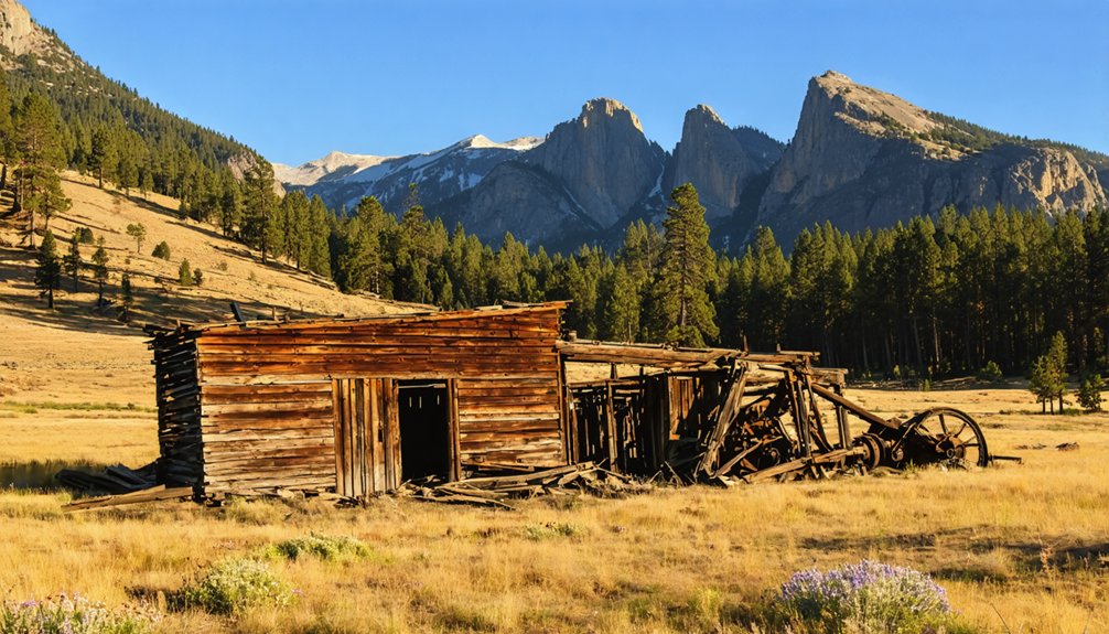
Bodie history truly began when the Standard Company struck profitable deposits in 1876, transforming twenty miners into 7,000–10,000 residents by 1879. Gold mining built 2,000 structures, including Wells Fargo banks, hotels, and saloons across this remote Mono Basin settlement.
You’ll find authentic freedom exploring 110 preserved buildings today, maintained in “arrested decay” since California designated it a State Historic Park in 1962.
The Boone Store still displays 1920s merchandise on original shelves. Mining ceased in 1942, leaving this National Historic Landmark exactly as prospectors abandoned it—no restoration, just preservation of California’s official gold rush ghost town.
Main Street once stretched a mile long with 65 saloons serving the bustling population of miners and fortune seekers.
Bodie pioneered hydroelectric technology with the first long-distance transmission line delivering power to its stamp mill operations.
Tioga Pass Mining Sites: High-Country Relics Inside Yosemite’s Backcountry
While Bodie’s weathered buildings tell stories of gold rush prosperity on the valley floor, Yosemite’s eastern boundary harbors even more remote mining relics scattered across windswept ridges above 10,000 feet.
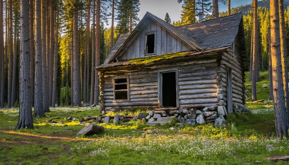
You’ll find Bennettville and Dana City along Tioga Pass—ghost settlements born from the Great Sierra Consolidated Silver Company‘s ambitious 1881 venture. Eastern investors poured capital into consolidating Tioga Hill’s claims, extending a tunnel 1,784 feet without striking profitable ore.
Operations ceased abruptly on July 3, 1884.
What remains? Log cabins at Bennettville, stone foundations near Mount Dana, and the Great Sierra Wagon Road—an 1882 engineering feat hauling eight-ton machinery up steep grades. The road’s construction relied on Chinese workers who used hand tools and blasting powder to carve the route through challenging terrain. The Golden Crown Mine sits near Mono Pass at 10,600 feet, surrounded by whitebark pine trees that miners harvested for construction.
These high-country relics offer unguarded access to California’s mining past, where speculative dreams met harsh alpine reality and left scattered evidence across Yosemite’s backcountry.
Hornitos: From 15,000 Residents to a Near-Empty Mother Lode Landmark
Twenty-five miles south of Coulterville, Hornitos swelled from a Mexican mining camp founded around 1848 to a Mother Lode hub of 15,000 residents by 1870, then collapsed to just 38 people by 2020 as gold deposits ran dry.
You’ll find the town’s 1860s commercial core—anchored by a Wells Fargo office that processed millions in gold shipments—now reduced to stone ruins, a Masonic lodge built in 1856, and scattered brick saloons along a central plaza.
Today’s visit reveals California Historical Landmark No. 333, where above-ground cemetery mounds, active St. Catherine’s Catholic Church, and visible tunnel depressions mark the physical remnants of a once-notorious frontier settlement. The camp earned its name from the distinctive above-ground tombs that resembled small ovens, constructed by Mexican miners when the hard ground made traditional burials impractical. Underground tunnels once connected saloons to bordellos, allowing discreet passage between establishments during the town’s rowdy frontier era.
Peak Gold Rush Era
From its 1850 founding as a settlement for Mexican miners expelled from Quartzburg, Hornitos transformed into one of California’s wealthiest and most formidable mining camps within a single decade.
By the mid-to-late 1850s, you’ll find records showing population dynamics that brought 6,000 residents to this once-outcast community, eventually peaking at 15,000 by the 1860s.
The town’s mining heritage generated extraordinary wealth—armed stagecoaches transported $40,000 in gold daily to the mint.
You could witness 36 saloons, 12 hotels, and freight routes connecting Stockton to Los Angeles through Hornitos.
The Mount Gaines mine alone extracted over $7 million in gold.
This prosperity attracted ex-president Ulysses S. Grant in 1879 and built D. Ghirardelli’s chocolate fortune through his merchandising operations.
Wells Fargo & Co. established its first Mariposa County office here in 1852 to manage the flood of mining profits flowing through the booming camp.
Hornitos became the first incorporated town in Mariposa County in 1872, cementing its status as a vital economic hub in the Mother Lode region.
Historic Wells Fargo Office
The adobe walls and historic marker at Hornitos’ southern edge mark where the first Wells Fargo office in Mariposa County opened for express business in 1853, three years before the town’s post office received its federal charter.
You’ll find the plaque 150 feet north of the original site, where daily shipments of $40,000 in gold dust and bullion once departed for the mint under armed guard.
Hornitos history turned on this strategic transfer point—linking stage routes from Stockton through Snelling to mining camps across the Mother Lode.
Wells Fargo covers sent from here to Downieville and Placerville prove the office’s integration into California’s statewide express grid, processing drafts and commercial correspondence that made remote claims financially viable until regional mines played out.
The town’s population peaked at 15,000 during the gold rush era, when this Wells Fargo station processed its highest volume of precious metal transfers.
Local merchants who relied on the station’s banking and express services sometimes became Wells Fargo agents themselves, deepening the company’s reach into mining communities.
Visiting Today’s Ghost Town
When you approach Hornitos along Bear Valley Road today, forty or fifty residents occupy buildings where 15,000 gold-seekers once crowded the commercial blocks during the 1850s boom.
You’ll find bullet holes still piercing door casings from gunfights that defined Hornitos history as one of the roughest camps in the Mother Lode.
Walk the streets where fandango halls and saloons once connected through underground tunnels, allowing outlaws like Joaquin Murrieta to evade capture.
The cultural significance remains visible in St. Catherine’s Catholic Church overlooking above-ground graves—those “little ovens” that gave the town its name.
Ghirardelli’s original store site and scattered stone ruins mark where $8 million in gold funded an empire of gambling, drinking, and commerce before decline transformed this incorporated city into California’s most tangible ghost town.
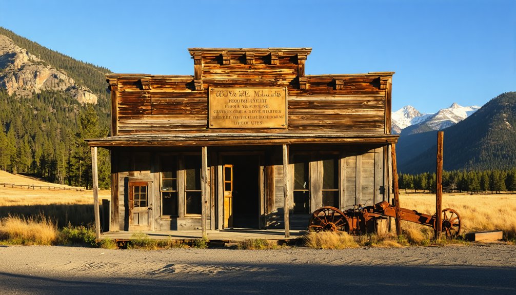
Coulterville: The Semi-Ghost Town That Welcomed Roosevelt and Muir
When you walk Coulterville’s Main Street today, you’re tracing the same route President Theodore Roosevelt and naturalist John Muir followed en route to Yosemite Valley, passing beneath the infamous “Hang Tree” oak where vigilante justice claimed Leon Ruiz in 1856.
Founded in 1850 as Maxwell Creek, this gold-rush settlement survived three catastrophic July fires—in 1859, 1879, and 1899—that burned the town to the ground, each time rebuilding its stone and wood storefronts on the original footprint.
The Jeffery Hotel, operating since 1851, still anchors the historic corridor that once staged thousands of Yosemite-bound travelers, though the town’s population has dwindled from 3,000 boom-era miners to a semi-abandoned remnant of Mother Lode prosperity.
Historic Buildings and Landmarks
Walking down Coulterville’s Main Street Historic District today, you’ll encounter 24 contributing structures that form California Historical Landmark No. 332 and National Register Historic District #82002205—a designation that captures roughly half the town’s surviving architectural fabric.
Key landmarks you can explore independently:
- Sun Sun Wo Mercantile (circa 1851)—one of the Mother Lode’s oldest adobe structures, preserving original shelves from what was once the region’s largest Chinatown’s premier trading center.
- Northern Mariposa County History Center—built within the stone walls of the Mother Lode’s first hotel ruins.
- Gazzola Building—1850s stone structure that stored wagon-hauled Yosemite ice blocks for saloon operations.
- Post-1899 commercial blocks—Coulterville architecture rebuilt after the Great Fire on earlier masonry shells.
These structures document Chinese heritage and frontier commerce without bureaucratic oversight.
Gateway to Early Yosemite
As Coulterville’s gold-bearing gravels began yielding diminishing returns in the late 1860s, town merchants and hoteliers turned their attention twenty-five miles east to Yosemite Valley—a destination that promised reliable seasonal traffic to replace uncertain mining revenues.
You’ll find that Coulterville history pivoted decisively on June 17, 1874, when its toll road became the first stagecoach route reaching Yosemite’s floor.
Though the Big Oak Flat Turnpike immediately eroded profits, Coulterville established itself as a primary supply hub and staging point.
The road network you can still trace via modern Greeley Hill Road transformed visitor demographics, replacing pack-trail expeditions with regular stage service.
This infrastructure secured Coulterville’s dual economic identity—mining town and gateway—sustaining commerce that outlived initial Gold Rush fortunes and cementing Yosemite access as the town’s enduring legacy.
Briceburg and River Corridor Settlements: Faded Hubs Along the Merced
- Emory’s quarry complex – rail sidings, worker boarding houses, and stone-loading platforms served Yosemite Valley Railroad operations.
- Feliciana Bridge site – connecting north-bank industrial nodes to Highway 140.
- Burma Grade – steep truck road linking rim mines to river shipping points.
- Goods Gulch Mine – hard-rock workings above the canyon floor.
Only foundations and machinery fragments remain.
Foresta and Wawona: Historic Enclaves Within Yosemite’s Boundaries
Deep within Yosemite National Park‘s boundaries, two private enclaves preserve fragments of the region’s pre-park history as living anachronisms.
Foresta history begins with James McCauley’s original holdings and the 1912 Foresta Land Company’s failed resort subdivision—now a scattered cluster of cabins at 4,300 feet elevation. The 2009 Big Meadow Fire severed Foresta Road, abandoning its southern corridor and leaving this inholding semi-isolated among meadows and charred foundations.
Wawona significance stems from its gateway role along the South Fork Merced, functioning as a traveler’s stop since before federal designation.
Both communities exist as private islands within federal wilderness, their grandfathered property rights creating curious jurisdictional patchwork where residential life persists amid protected lands—tangible reminders of settlement patterns that predate centralized park management.
Planning Your Ghost Town Tour: Access, Seasons, and Trail Conditions
While private enclaves preserve inhabited fragments of Yosemite’s settlement past, the region’s true ghost towns demand practical reconnaissance before you visit—high-elevation access roads impose seasonal dictates that separate summer explorers from winter shutouts.
High-elevation access roads impose seasonal dictates that separate summer explorers from winter shutouts at Yosemite’s ghost towns.
Primary routes to Yosemite-area ghost sites split by geography: Tioga Road (Highway 120) carries eastbound traffic over Tioga Pass to Bennettville, Dana Village, and Golden Crown Mine trailheads, while northbound U.S. 395 feeds State Route 270’s thirteen-mile spur toward Bodie, the final three miles grinding over washboarded dirt that punishes low-clearance vehicles.
Essential road access and seasonal precautions:
- Snow closures lock Tioga Pass (10,000+ ft) late fall through late spring, with opening dates varying yearly.
- One-hour drives from Lee Vining or Mammoth Lakes reach Bodie; expect no fuel, food, or services.
- Summer thunderstorms and lightning threaten exposed alpine routes during afternoon monsoon patterns.
- Early arrival secures limited trailhead parking at peak-season Tioga ghost sites.
What to Expect: Preservation Styles and Interpretive Opportunities
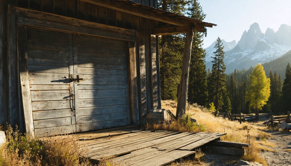
When you arrive at Bodie State Historic Park, you’ll encounter a preservation philosophy radically different from the polished, reconstructed history sites that dominate California’s interpretive landscape—here, park managers practice “arrested decay,” stabilizing buildings just enough to prevent structural collapse while refusing cosmetic restoration, reconstruction, or modernization.
Weathered wood, broken windows, and sagging roofs remain untouched, documenting abandonment rather than erasing it. Inside, original furniture, canned goods, and personal belongings sit where residents left them, covered in authentic dust and cobwebs.
You’ll view most interiors through doorways and windows, though Miller House offers limited entry. The museum and visitor center provide context, while guided stamp mill tours explain ore-processing technology.
Unlike Yosemite History Center’s interpretive signage connecting each structure to specific trades and people, Bodie emphasizes self-guided exploration through maps, allowing you to pace your own discovery of these preservation techniques.
Frequently Asked Questions
Are There Guided Tours Available at Any of These Ghost Towns?
You’ll find tour options at Bodie State Historic Park, where ranger-led walks explore the preserved 1870s–1880s townsite daily during season. Local guides interpret mining history, architecture, and frontier life. Other ghost towns require self-guided exploration.
For those seeking further adventure, there are numerous ghost towns near Zion National Park that offer a glimpse into the past. These sites provide unique opportunities to wander through remnants of once-thriving communities, reflecting the rich history of the region. Whether you explore on your own or join a guided tour, you’ll uncover fascinating stories from the days of the Wild West.
Can I Camp Overnight Near Bodie or Other Ghost Town Sites?
You can’t camp inside Bodie State Historic Park—it’s day-use only—but you’ll find free dispersed camping along Bodie Road on adjacent public lands. Check camping regulations for other ghost towns and explore nearby campgrounds on federal lands.
Are the Ghost Town Buildings Safe to Enter and Explore?
Most ghost town buildings aren’t safe to enter due to deteriorating building conditions from decades of weathering. You’ll need strict safety precautions—Bodie’s structures are maintained in “arrested decay” and officially restricted to exterior viewing only.
What Photography Restrictions Exist at These Historic Mining Sites?
You’ll face photography permits for commercial work, group shoots, and interior access; historical preservation rules ban touching artifacts, moving objects, or entering closed structures—freedoms traded for protecting fragile mining-era remnants at Bodie and surrounding sites.
Do Any Ghost Towns Charge Entrance or Parking Fees?
Bodie State Historic Park requires entrance fees and parking costs, established after its 1962 state park designation. You’ll find free access at Hornitos, Coulterville, and Yosemite’s high-country sites like Bennettville, though standard park admission applies.
References
- https://en.wikipedia.org/wiki/List_of_ghost_towns_in_California
- https://www.yosemite.com/yosemite-mariposas-small-town-charm/
- https://www.myyosemitepark.com/things-to-do/attractions/bodie/
- https://www.tripadvisor.com/Attractions-g28926-Activities-c47-t14-California.html
- https://www.nationalparkstraveler.org/2014/11/ghost-towns-yosemite-national-parks-high-country25937
- https://californiahighsierra.com/trips/explore-ghost-towns-of-the-high-sierra/
- https://www.youtube.com/watch?v=rCpq-o7egVc
- https://www.npca.org/articles/1054-hidden-yosemite
- https://www.parks.ca.gov/bodie
- https://modernhiker.com/bodie-state-historic-park/


