You’ll find three fascinating ghost towns within 45 minutes of Zion National Park. Grafton, just 12 miles southwest, showcases five restored Mormon settlement structures from 1859 and a haunting pioneer cemetery. Silver Reef preserves a unique sandstone silver mining boom town that produced $25 million worth of ore by 1879. Old Iron Town State Park, 20 miles west of Cedar City, features intact beehive kilns from Utah’s first failed industrial settlement. Each site offers distinct insights into Southern Utah’s challenging frontier history and requires careful planning for best exploration.
Key Takeaways
- Grafton, 12 miles southwest of Zion, features five restored structures, a historic cemetery, and weathered buildings against sandstone cliffs.
- Silver Reef was a silver mining boom town with 2,000 residents that produced 7 million ounces of silver worth $25 million.
- Old Iron Town State Park, 20 miles west of Cedar City, preserves an 1868 industrial settlement with intact beehive kilns and furnaces.
- Best visiting times are late March–May or September–October; morning departures help avoid monsoon flash-flood risks and allow safe return.
- Grafton is accessible via a 15-minute drive from Springdale on unpaved roads or a 6.2-mile cycling route from Rockville.
Grafton Ghost Town: Zion’s Closest Historic Settlement
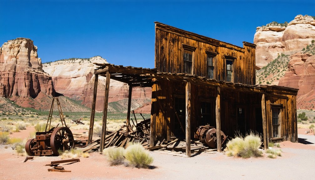
Just twelve miles southwest of Zion National Park, Grafton stands as Utah’s most photographed and meticulously preserved ghost town—a Mormon farming settlement that rose along the Virgin River floodplain in 1859 and fell silent by 1944.
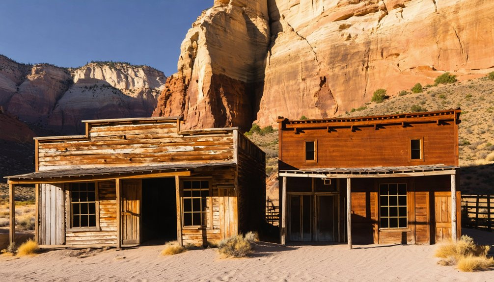
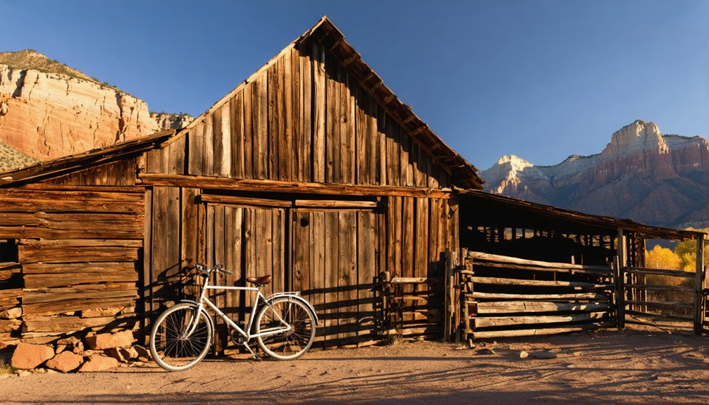
You’ll find five restored structures from the original thirty buildings, including a schoolhouse, barn, and pioneer homes that showcase the region’s Mormon heritage.
The Grafton significance extends beyond architecture—its cemetery tells harsh frontier stories through graves of flood victims and settlers killed in conflicts with Native groups.
Originally called Wheeler, the town relocated upriver after the catastrophic 1862 flood destroyed the first townsite.
The town briefly became a ghost town in 1866 when Brigham Young ordered the consolidation of towns for safety after conflicts with Native Americans, though farmers returned daily to tend their fields.
Today, the Grafton Heritage Partnership manages this National Register site, offering self-guided tours across 150+ acres of authentic 19th-century landscape.
Plan for 1-2 hours to fully explore the grounds, walk through accessible buildings, and imagine frontier life while children engage with the educational signage scattered throughout the property.
How to Reach Grafton From Springdale and Rockville
To reach Grafton from Springdale, you’ll drive west on UT-9 for approximately 4–5 miles to Rockville’s eastern edge, then turn south onto Bridge Road (Grafton Road).
The route requires crossing the historic single-lane Rockville Bridge over the Virgin River before shifting to a 3-mile dirt and gravel road that leads directly to the ghost town.
While most passenger vehicles handle the unpaved section in dry conditions, recent rain can create muddy, rutted segments that challenge low-clearance cars. To minimize the dust clouds that arise on the dirt road, drive slowly and maintain distance from other vehicles. At approximately 0.3 miles past the bridge, the road divides and you should take the right fork to continue toward Grafton.
Rockville Road and Turnoff
From Springdale or the south entrance of Zion National Park, you’ll drive 4–5 miles west on UT-9 through the town corridor to reach Rockville, where Grafton Road begins. This settlement, rich in Rockville history, marks your gateway to the ghost town.
Look for Bridge Road on the east side of town—your turnoff south.
Key navigation points:
- Turn south from UT-9 onto Bridge Road at Rockville’s main junction
- Cross the 1926 iron lattice-truss bridge spanning the Virgin River
- Drive 0.3 miles to the first fork; stay right toward Grafton Road
- Continue 1.0 mile to the second junction at 1.3 miles; bear right again
The entire route from Rockville to Grafton covers 3.3 miles, shifting from pavement to gravel as you head south. The trail follows a wide gravel bench below cliff bands to the south and fields along the Virgin River to the north. After crossing cattle guards along the route, you’ll continue on the paved road for approximately 0.5 miles before encountering private dirt roads that veer off toward local properties.
River Crossing and Conditions
Unlike many ghost towns hidden behind river fords, Grafton is accessible year-round via a standard paved bridge over the Virgin River at Rockville.
This two-lane bridge eliminates crossing safety concerns under normal conditions, making the route suitable for passenger cars, RVs, and bicycles.
However, river conditions still matter—Grafton sits on the Virgin River floodplain, where historic floods once destroyed farmland.
After heavy rain or monsoon storms, roadside dips and washes near the river may temporarily hold water, even though the bridge itself stays above the flow.
The final two unpaved miles can turn to slick mud during wet weather, reducing traction and clearance. The dirt road continues to the end of the Grafton settlement, where the remaining historic structures stand.
The drive from Springdale or Rockville takes about 15 minutes under normal conditions.
Monitor weather forecasts before your visit, and avoid the route during active flash-flood warnings to guarantee safe passage.
What to See at Grafton: Buildings, Cemetery, and Landscape
Grafton’s landscape presents one of the Southwest’s most photographed ghost town settings, where approximately five weathered structures stand against a backdrop of massive red and tan sandstone cliffs rising from the Virgin River floodplain.
Among these captivating locations, abandoned sites in Keweenaw Peninsula tell their own stories of the past. The area is scattered with remnants of old mines and decaying buildings, offering a haunting yet beautiful glimpse into the region’s rich history. Explorers and photographers alike are drawn to the unique charm of these forgotten places, seeking to capture the essence of a bygone era.
The Grafton architecture showcases pioneer ingenuity: the 1886 adobe church-schoolhouse features hand-made colored bricks on a lava-rock foundation, while the restored Alonzo H. Russell homestead displays three main rooms and wraparound porches.
Key structures you’ll encounter:
- Church-schoolhouse with lumber hauled 75 miles from Mount Trumbull
- John Wood farmhouse complex (1929), representing later occupation
- Russell’s log barn, granary, and split-rail fence
- Relocated log cabin from the film *Ramrod*
Cemetery stories reveal settlement hardships through 1860s–1870s headstones, including five Ballard children who died before age ten and flood victims. The cemetery is positioned south of the old dirt road that leads into Grafton, where interpretive signs provide context for the pioneers’ sacrifices.
The schoolhouse served multiple functions beyond education, operating as a community meeting place, church, and venue for dances that often lasted until dawn with participation from nearby cowboys.
The Rise and Fall of a Mormon Farming Community
When Brigham Young launched his ambitious colonization of southern Utah in the mid-1850s, he envisioned a network of Mormon farming settlements that would transform the Virgin River corridor into a productive agricultural heartland—what church leaders called “Dixie” for its cotton-growing potential.
Settlers built intricate irrigation systems, raised cotton, wheat, and fruit orchards, and practiced Mormon agriculture through cooperative labor and communal water management.
Yet the Virgin River’s violent floods repeatedly destroyed their infrastructure. Thin soils, droughts, and geographic isolation undermined economic viability.
Despite remarkable community resilience—settlers rebuilt ditches and replanted fields multiple times—environmental realities eventually overwhelmed religious determination.
Silver Reef: Southern Utah’s Sandstone Silver Mining Boom
While Mormon farmers struggled against floods and thin soils in nearby canyon settlements, a different kind of boom erupted fifteen miles northeast of Zion in 1866.
Prospector John Kemple discovered silver within sandstone cliffs—the only known North American occurrence of this geological anomaly. What began as “Rockpile” transformed into Silver Reef, a thriving boom town that reached 2,000 residents by 1879.
Silver Reef’s Peak Years (1876-1890):
- 33 operating mines extracting ore from sandstone formations
- 7 million ounces of silver worth $25 million produced
- Complete infrastructure including hotels, Wells Fargo office, and Chinatown
- 1,000 miners arrived during the “Pioche Silver Stampede” of 1877
Old Iron Town State Park: Industrial Ruins Near Cedar City
Twenty miles west of Cedar City, rusted machinery and crumbling stone kilns mark Utah’s ambitious but ill-fated experiment in frontier industrialization.
Old Iron Town State Park preserves the 1868 settlement where the Union Iron Company attempted to supply Mormon pioneers and railroads with locally smelted ore.
You’ll find a remarkably intact beehive charcoal kiln, furnace foundations, and an erastra grinding stone along a self-guided quarter-mile trail.
Economic shocks—the Panic of 1873 and crippling transportation costs—killed operations by 1876. The site became Utah’s first ghost town by the late 1880s.
This free, year-round destination offers authentic industrial heritage exploration without crowds or commercialization.
Reach it via Highway 56 west, then south on gravel Old Iron Town Road for ghost town exploration on your terms.
Cycling and Photography Opportunities at Grafton
As you pedal the 6.2-mile route from Majestic View Lodge in Rockville, the change from pavement to packed gravel signals your approach to Utah’s most photographed ghost town.
The transformation from smooth asphalt to crunching gravel beneath your tires marks the gateway to Grafton’s weathered history.
Grafton’s year-round accessibility makes it ideal for independent exploration, with cycling routes following old dirt roads through five restored buildings where Butch Cassidy and the Sundance Kid was filmed.
Photography tips for capturing Grafton’s essence:
- Visit during morning hours to avoid harsh afternoon sun on unshaded structures
- Frame buildings against Zion’s red cliffs for dramatic backdrop compositions
- Explore the 1860s cemetery for atmospheric historical documentation
- Utilize tree-lined Virgin River fields for natural landscape framing
The unpaved Bridge Road approach adds 30 minutes to your journey, but preserves the remote character that attracted filmmakers since 1929.
Planning Your Ghost Town Itinerary Around Zion
Beyond the photogenic structures of Grafton, a successful ghost town exploration near Zion depends on strategic timing and route planning.
Visit late March–May or September–October when temperatures stay between 70–85°F and unpaved roads remain passable. You’ll navigate Grafton’s 3.5-mile access road (last 2 miles unpaved) from Rockville, then continue 40–50 minutes southwest to Silver Reef near Leeds for a complete loop.
Budget 1–2 hours per site, respecting ghost town preservation protocols—stay off unstable structures and honor posted boundaries. The historical significance of these settlements deserves your careful stewardship.
Fuel up beforehand, download offline maps for intermittent cell coverage, and return before sunset to avoid unlit roads and open-range livestock. Morning departures sidestep monsoon flash-flood risks.
Frequently Asked Questions
Are Dogs Allowed at Grafton Ghost Town?
Dogs aren’t explicitly banned, but no official dog friendly policies exist at Grafton Ghost Town. You’ll want to leash your companion and respect private property while exploring this photogenic slice of Grafton history responsibly.
What Is the Best Time of Year to Visit These Ghost Towns?
The best season is spring (April–May) or fall (September–October), when you’ll enjoy mild temperatures, dry roads, and fewer crowds. Weather considerations include avoiding summer’s extreme heat and winter’s muddy, icy access conditions.
Do Any Ghost Towns Near Zion Charge Entrance Fees?
Like unlatched doors welcoming wanderers, ghost towns near Zion don’t charge entrance fees. You’ll find Grafton and Silver Reef freely accessible, though donation boxes support preservation. Only Silver Reef’s museum requests modest admission for indoor exhibits.
Can You Camp Overnight at Grafton or Other Ghost Towns?
No, you can’t camp overnight at Grafton—camping regulations explicitly prohibit it. Ghost town amenities don’t exist there, but you’ll find free dispersed sites nearby on Smithsonian Butte Road instead.
Are Guided Tours Available at Any of These Ghost Town Sites?
No, guided tour options aren’t available at Grafton or nearby ghost towns. You’ll explore independently using educational signs at two main buildings that explain the sites’ historical significance. The Grafton Heritage Partnership provides self-guided resources instead.
References
- https://www.canyoneeringusa.com/zion/hikes/grafton
- https://www.youtube.com/watch?v=0RLITc0eKoc
- https://www.visitutah.com/things-to-do/history-culture/ghost-towns
- https://www.utahlifemag.com/blog/post/4-ghost-towns
- https://www.americansouthwest.net/utah/zion/grafton_ghost_town.html
- https://www.zionadventurephotog.com/single-post/grafton-ghost-town-things-to-do-around-zion-national-park
- https://en.wikipedia.org/wiki/Grafton
- https://graftonheritage.org
- https://www.tripadvisor.com/Attraction_Review-g28965-d196195-Reviews-Grafton-Utah.html
- https://graftonheritage.org/history-settlement/


