You’ll find Oregon’s coastal ghost towns shaped by natural disasters and industrial collapse. Bayocean, once envisioned as a resort destination with 2,000 residents by 1914, surrendered to Pacific erosion by 1971. Scottsburg, established in 1850 as a strategic Umpqua River port, was destroyed in the catastrophic 1861-62 flood. Old Kernville thrived on fishing and lumber until WWI-era timber depletion triggered its decline. These abandoned settlements reveal how atmospheric rivers, coastal erosion, and resource exhaustion transformed thriving communities into archaeological remnants that tell Oregon’s maritime history.
Key Takeaways
- Bayocean, founded in 1906, was destroyed by coastal erosion from jetty modifications and winter storms, with its last structure falling in 1971.
- Scottsburg, established in 1850 as a strategic seaport, was completely destroyed by the catastrophic Great Flood of 1861-62 and subsequently abandoned.
- Old Kernville thrived on fishing and lumber industries, supplying Sitka spruce during WWI before declining in the 1920s due to resource depletion.
- Coastal erosion, flooding, and natural disasters were primary factors causing towns like Bayocean and Scottsburg to become ghost towns on Oregon’s coast.
- Infrastructure failures, including jetty modifications and environmental changes, accelerated the abandonment of several coastal communities by altering natural shoreline patterns.
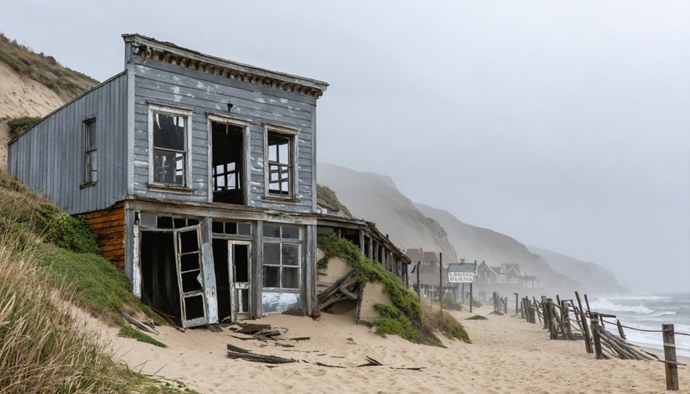
Bayocean: The Atlantic City of the West
Where did Oregon’s most ambitious seaside resort vanish to? You’ll find Bayocean’s story written in sand and engineering hubris.
Founded in 1906 by Thomas Benton Potter and his son Thomas Irving, this “Atlantic City of the West” emerged through meticulous urban planning—paved streets, private railroad, and 600 lots sold within a year.
Meticulous planning transformed raw spit into instant metropolis—600 lots sold before the first resident unpacked their bags.
By 1914, 2,000 residents enjoyed a three-story hotel, 160-foot heated natatorium, and 1,000-seat theater on Tillamook Spit.
Then came coastal erosion. The north jetty built between 1914-1917 altered wave patterns, triggering relentless shoreline retreat.
Winter storms claimed cabins in the late 1920s. By 1938, fifty-nine homes surrendered to the Pacific.
The 130-foot wooden yacht transported visitors from Portland in 12 hours, though navigating the entrance bars sometimes delayed trips for days.
The 1952 gale breached the spit entirely. The last structure fell in 1971, leaving only wilderness where luxury once stood.
Today, sand re-accumulated after a second jetty’s construction in the 1970s, transforming the site into Bayocean Peninsula County Park with a 7.8-mile hiking loop where the resort once thrived.
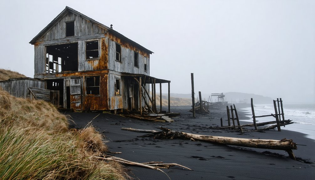
Old Kernville: Remnants of Fishing and Lumber Heritage
You’ll find Old Kernville’s origins in Daniel Kern’s 1896 cannery establishment on the Siletz River, 500 feet above Coyote Rock, marking North Lincoln County’s first major industrial venture.
The settlement’s dual economy emerged when settlers constructed a sawmill across the river, creating parallel communities that thrived on fishing and lumber operations.
World War I transformed this modest outpost into a bustling center as military demand for milled spruce aircraft components drove unprecedented production levels at the sawmill.
The town experienced its heyday with Wild West shootouts that characterized frontier life in the mining community.
Access to the site today requires visitors to complete security verification to protect against automated bots attempting to compromise the historical records database.
Kern Brothers Cannery Operations
When Daniel Kern and John H. Kern established their packing company in 1896, they positioned the cannery on the Siletz River’s north bank near its mouth.
You’ll find that salmon canning operations formed the economic backbone of this isolated settlement, accessible only by boat in those early years.
The Portland-based brothers managed a thriving enterprise that processed the region’s abundant fish runs.
Across the river, settlers built a sawmill, creating a dual-industry economy.
However, the cannery changed hands in 1907, when new owners dismantled and relocated it to the south bank, renaming it Elmore Cannery.
Industry decline began in the 1920s, gradually shifting the area’s economic focus toward logging as fishing operations diminished and eventually ceased entirely.
The settlement’s name honored the Kern brothers, distinguishing this Oregon coastal location from other places sharing the Kernville designation.
After a bridge was built, residents gradually moved away from the area, contributing to Old Kernville’s transformation into a ghost town.
World War I Prosperity
The outbreak of World War I in 1914 transformed Kernville from a modest fishing and lumber settlement into a crucial supplier of Sitka spruce for airplane manufacturing.
You’ll find that Oregon’s coastal forests became strategically essential when the federal government established the United States Spruce Production Division in 1917, deploying over 7,500 soldiers to harvest timber.
The timber industry experienced unprecedented demand, with Kernville’s sawmill operating at 30,000 feet daily capacity.
Workers affiliated with the Industrial Workers of the World struck for better conditions in summer 1917, demanding shorter hours and increased wages.
Government intervention produced labor reforms through the company-backed Loyal Legion of Loggers and Lumbermen, which implemented eight-hour workdays while prohibiting strikes.
This wartime boom period lasted through 1926, creating Kernville’s most prosperous era.
The region’s development accelerated with roads built by 1926 and hydroelectric power plants constructed along the Kern River to support the growing community.
The community’s decline accelerated after 1926 when a new drawbridge connected the north and south sides of the Siletz River, enabling residents and businesses to relocate to the more accessible new Kernville along the improved highway system.
Dual Settlement History
Following North Lincoln County’s opening for settlement in 1895, Daniel Kern and his brother John established the area’s first major industry by constructing a large fish cannery on the Siletz River’s north bank in 1896. This site, positioned 500 feet above Coyote Rock, marked the first white settlement where Indigenous history and early Native trade had long flourished along these waterways.
John served as postmaster when operations began, while a sawmill rose on the river’s south side, accessible only by boat. The Dawes Act of 1887 had transformed former Siletz Reservation lands into 80-acre homestead allotments, drawing settlers who combined subsistence farming with resource extraction. Early settlers also established homesteads along Salmon River, Drift Creek, Schooner Creek, Cougar Mountain, and the broader Siletz River drainage during this pioneering period.
The thriving salmon fishing industry that initially sustained Kernville declined by the 1920s, fundamentally altering the economic foundation of the settlement. However, inadequate roads plagued development until the 1926 drawbridge prompted complete relocation, leaving Old Kernville abandoned with scattered remnants of its dual industrial heritage.
Scottsburg: Pioneer Settlement Lost to the Great Flood
You’ll find Scottsburg’s story begins in 1850 when Illinois pioneer Levi Scott established the settlement at the head of tidewater on the Umpqua River, positioning it as a critical outfitting point for pack trains heading to Oregon’s interior and California’s gold fields. The town thrived as a seaport and transfer station where hundreds of pack animals loaded simultaneously.
But the 1861 great flood destroyed Lower Scottsburg and accelerated its decline as newer ports opened closer to major markets. What remains today stands as a testamentary proof to how natural disaster and economic shifts transformed a predicted metropolis into an official ghost town.
Though timber industry revivals in the 1940s-1950s briefly breathed life back into the area.
Early Settlement in 1850
When Levi Scott arrived from Illinois in 1844 and homesteaded at the head of tidewater on the Umpqua River six years later, he positioned his settlement to capitalize on a crucial geographic advantage: the site marked the furthest point inland that seagoing vessels could navigate, located 20 miles from the ocean and 18 miles from the Oregon Coast.
This strategic location, previously inhabited by the Lower Umpqua native people, established settlement patterns that would define the town’s commercial future.
By 1850, log cabins and tents dotted the landscape as Scott’s vision materialized into a functioning river port.
The settlement’s dual structure emerged quickly—a lower town housing business operations and mills at tidewater, with an upper town one mile upstream serving as the primary distributing center for goods moving into Oregon’s interior.
The 1862 Flood Disaster
Between November 1861 and January 1862, atmospheric rivers delivered weeks of relentless rain across the Pacific Northwest while heavy snow accumulated in the coastal mountains, setting the stage for what would become Oregon’s most catastrophic flood.
When rapid snowmelt combined with continuing storms, Scottsburg’s position on Kings River proved fatal. The entire town vanished beneath surging floodwaters, its structures and infrastructure obliterated.
You’ll find that survivors attempted rebuilding on higher ground, but Cole Slough’s waters struck again, forcing final abandonment. The flood aftermath reshaped communities throughout Oregon—Linn City disappeared permanently, while Champoeg’s governmental legacy drowned.
River ecology transformed dramatically as channels carved new paths through valleys. Scottsburg’s residents relocated and renamed their settlement Centerville, leaving behind only memory where a thriving hub once stood.
Decline and Remnants Today
Though Scottsburg’s catastrophic flood destruction in 1861-1862 proved immediately devastating, the settlement’s economic decline had already begun as newer ports positioned closer to southern Oregon and northern California markets eroded its competitive advantage.
Railroad expansion inland eliminated the necessity for river-dependent transfer stations, ending the pack train operations that once saw 500 animals loading daily. Today, you’ll find Scottsburg designated as an official ghost town, with archaeological remnants marking where Lower, Middle, and Upper sections once thrived.
The timber industry brought temporary revival during the 1940s-1950s, yet urban decay ultimately prevailed. Limited preservation efforts manifest through historical markers documenting the pioneer settlement’s significance, while annual celebrations honoring founder Levi Scott maintain community connection to this vanished distribution hub.
Mabel: The Timber Town That Became Oregon’s Third Largest
Three miles above the coastal entrance in Lane County, settlers broke ground on a sawmill in 1870 that would anchor one of Oregon’s most remarkable timber settlements.
Mabel’s strategic position in timber-rich wilderness fueled explosive growth through the timber industry, propelling it to become Oregon’s third largest town by the late 19th century. The sawmill processed abundant old-growth stands while railroad connections expanded market reach during peak demand.
However, resource depletion triggered inevitable decline. Federal land policies, including the 1916 O&C reconveyance, compounded pressures as timber tracts dwindled.
Sherars Bridge: A Well-Preserved Gateway to the Past

When Peter Skene Ogden documented an Indian camp and slender wooden bridge spanning the Deschutes River in 1826, he recorded what would become one of Oregon’s most strategically significant crossing points.
You’ll find Sherar’s Falls marked the Tygh people’s village of Tilxni, where indigenous history runs deep through ancient salmon fishing traditions.
Joseph and Jane Sherar transformed this crossing in 1871, investing $82,000 total to build infrastructure connecting gold fields eastward.
Their toll bridge, hotel, and improved wagon roads served thousands seeking fortune and land.
Today’s concrete span at Highway 216 milepost 8 preserves access to visible petroglyphs preservation sites carved into riverside rocks—tangible evidence of millennia-old occupation predating any European settlement by thousands of years.
Shaniko: Oregon’s Most Famous Ghost Town
Rising from the sagebrush plateau at 3,343 feet elevation, Shaniko stands as Oregon’s most recognized ghost town—a designation formally bestowed by the Oregon Centennial Commission in 1959.
Oregon’s most recognized ghost town since 1959, Shaniko rises from high desert sagebrush at 3,343 feet elevation.
Unlike coastal industrial ruins or lighthouse histories marking maritime decline, Shaniko’s collapse stemmed from railroad competition.
Founded in 1900 as the Columbia Southern Railroad terminus, you’ll discover remnants of its “Wool Capital of the World” era, when $3-5 million in annual wool sales sustained 600 residents.
The 1911 Oregon Trunk Railroad opening triggered swift abandonment, accelerated by downtown fire.
Today’s 20-25 inhabitants maintain historic structures including the 1900-1902 Shaniko Hotel, reopened in 2023.
The Shaniko Preservation Guild operates seasonal museums and festivals, preserving authentic Western commerce history without manufactured nostalgia.
Exploring Oregon’s Coastal Ghost Town Legacy
Along Oregon’s 363-mile coastline, ghost towns reveal distinct patterns of abandonment shaped by environmental forces, extractive industries, and infrastructure failures rather than the railroad competition that claimed inland settlements like Shaniko.
You’ll discover these coastal settlements document Oregon’s struggle between ambition and natural forces:
- Bayocean – Once dubbed “Atlantic City of the West,” this planned resort featured artificial islands and elaborate amenities before erosion claimed everything by 1926, leaving only maritime archaeology beneath the waves.
- Old Kernville – Near Newport, this cannery and sawmill town thrived on fishing and lumber until WWI demand shifted resources elsewhere, preserving pioneer-era structures.
- Scottsburg – Douglas County’s 1850 port hub collapsed after the Great Flood of 1862 devastated population centers.
- Jawbone Flats and Mabel – Marion and Lane County logging towns abandoned when timber operations ceased.
Frequently Asked Questions
Are Any Oregon Coastal Ghost Towns Accessible to Visitors Year-Round?
You’ll find Chitwood accessible year-round via the main coastal route, where you can explore abandoned ruins while experiencing authentic late 1800s atmosphere. Historical preservation efforts maintain this site’s accessibility, though few residents still inhabit the area.
What Safety Precautions Should I Take When Exploring Coastal Ghost Towns?
You’ll face a thousand hazards exploring abandoned coastal sites, so check tide tables, wear sturdy footwear, stay behind railings near cliffs, respect historical preservation boundaries, and research local folklore beforehand to navigate safely while honoring these freedom-rich ruins.
Can I Camp Overnight Near Oregon’s Coastal Ghost Town Sites?
You can’t camp on wet sand near coastal ghost town sites, but you’ll find dispersed camping options nearby in state or national forests. Always respect historical preservation areas and research local legends while maintaining Leave No Trace practices.
Which Coastal Ghost Town Offers the Best Photography Opportunities?
Bayocean offers you the most dramatic photography opportunities, combining abandoned structures with dynamic coastal landscapes. You’ll capture powerful ocean waves crashing against eroded foundations, creating moody compositions that showcase nature’s reclamation of this former resort community.
Are There Guided Tours Available for Oregon’s Coastal Ghost Towns?
You won’t find guided tours for Oregon’s coastal ghost towns like Bayocean. Instead, you’ll discover self-guided exploration through maps and road trips, where local legends and historical preservation rely on your independent spirit and research.
References
- https://en.wikipedia.org/wiki/List_of_ghost_towns_in_Oregon
- https://www.visitoregon.com/oregon-ghost-towns/
- https://www.deviantart.com/austinsptd1996/journal/Six-Iconic-Ghost-Towns-Within-Oregon-1109696435
- https://www.pdxmonthly.com/travel-and-outdoors/2025/10/oregon-ghost-towns-history
- http://www.photographoregon.com/ghost-towns.html
- https://thatoregonlife.com/2016/04/road-trip-ghost-towns-eastern-oregon/
- https://www.keystonevacationsoregon.com/blog/oregon-coast-ghost-towns-worth-visiting/
- https://traveloregon.com/things-to-do/culture-history/ghost-towns/
- https://en.wikipedia.org/wiki/Bayocean
- https://www.opb.org/news/article/oregon-bayocean-ghost-town-resort-tillamook-bay/


