You’ll find dozens of ghost towns along Route 66’s 2,448-mile stretch, remnants of communities that thrived after the highway’s 1926 designation but declined when Interstate 40 bypassed them in the 1960s-70s. California’s desert holds Amboy’s iconic neon sign and Goffs’ century-old schoolhouse, while Arizona’s Oatman still maintains 100 residents among wild burros. New Mexico’s Cuervo peaked at 300 people before I-40’s construction, and Texas towns like Texola preserve limestone jails and shuttered motor courts that tell stories of America’s roadside heritage.
Key Takeaways
- California’s Amboy, Goffs, and Bagdad feature 1950s neon signs, abandoned garages, and historic mining relics along desert stretches.
- Arizona’s Oatman retains over 100 residents and wild burros, while Goldroad and Hackberry show mining-era ruins.
- New Mexico’s Cuervo declined after I-40 bypassed Route 66, leaving a 1915 church and scattered abandoned structures.
- Texas-Oklahoma border towns like Texola, Alanreed, and Glenrio emptied after highway realignments and railroad decline.
- Preservation efforts include restored gas stations, open-air museums, and relocated historic buildings documenting Route 66’s heritage.
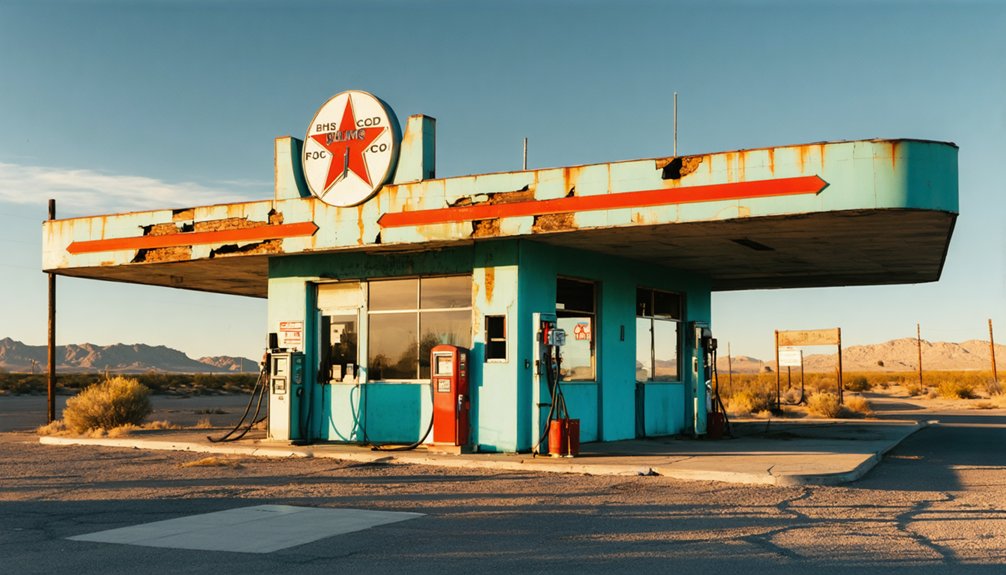
California’s Desert Relics Along the Mother Road
Where did California’s Route 66 travelers find respite in the unforgiving Mojave Desert? You’ll discover answers in towns like Amboy, where Roy’s 50-foot neon sign still beckons from the 1950s Googie era.
Roy’s towering neon beacon remains frozen in time, a Googie-era monument to desert wanderers seeking shelter along the Mother Road.
This mining-turned-railroad outpost operates today near Amboy Crater’s lava fields.
Goffs, over a century old, served the National Old Trails Road before Route 66’s alignment. Its schoolhouse now houses a visitor center.
Bagdad inspired the famous café film, though Tony’s Garage sits abandoned along the 36-mile National Old Trails section.
Chambless and Essex vanished when I-40 bypassed the original route, leaving scattered foundations and gas station remnants.
Calico emerged from a desert grave, revived to showcase its silver mining heritage along this stretch of desert terrain.
Albert Okura purchased Amboy in 2005 with plans to revitalize the town, including renovations scheduled for 2026 to reopen the motel and café.
These relics offer Hollywood nostalgia and prime desert photography opportunities for those seeking authentic freedom on America’s Mother Road.
Arizona’s Historic Mining Towns and Trading Posts
As Route 66 carved through Arizona’s mineral-rich landscape in 1926, it breathed new life into gold and silver towns that had already witnessed boom-and-bust cycles for decades. You’ll find Oatman, where gold discoveries in 1863 sparked one of Arizona’s most productive mining operations until closure in 1941. The highway kept it alive with over 100 residents today. Wild burros descended from miners’ pack animals roam the streets seeking food from tourists before returning to the hills each evening.
Near Goldroad’s accessible mines—now shrouded in ghostly claims—you can explore ruins from its 1902-1949 existence.
Hackberry’s silver mining legacy dates to 1874, though it reached ghost town status by 1919. Route 66’s opening in 1926 revived the town, though Interstate 40’s construction nearly ended it again.
The desolate Canyon Diablo, labeled “meaner than Tombstone,” represents the lawless mining era.
Off the main route, Chloride‘s 300 residents maintain mining legends through preserved storefronts and continuing operations since the 1860s.
New Mexico’s Artistic Enclaves and Railroad Remnants
When Route 66 opened through New Mexico in 1926, it transformed railroad settlements already experiencing their first cycles of growth and decline.
You’ll find Cuervo exemplifies this pattern—established in 1901 when the Chicago, Rock Island & Gulf extended tracks into Eastern New Mexico. It peaked at 300 residents after Route 66’s arrival.
The town supported two schools, churches, hotels, and doctors before Interstate 40‘s construction in the late 1960s split it apart.
Today, public art installations mark these abandoned sites, while community efforts preserve structures like the 1915 Santo Niño de Atocha Catholic Church. Despite official abandonment in 2011, occasional services are still held at the historic church. Carved stone over the entryway displays the names of the church’s founders: P. Martinez, Vic Segura, and Max Salas.
Nearby Newkirk, Glenrio, and Dilia display similar trajectories—railroad prosperity followed by highway commerce, then abandonment when interstates bypassed them entirely.
Oklahoma’s Abandoned Main Streets and Border Communities
Oklahoma’s border communities emerged during the railroad boom of the early 1900s, then experienced a second wave of prosperity when Route 66 brought automobile traffic through their main streets. Texola exemplifies this border town history, established in 1901 just one mile east of the Texas-Oklahoma line. The Chocktaw, Oklahoma and Gulf Railroad arrived in 1902, demonstrating clear railroad influence on settlement patterns. Among its remaining structures stands a limestone provincial jail, a testament to the town’s law enforcement infrastructure.
Route 66’s connectivity transformed these railroad stops into emblematic enclaves linking states together. Today, you’ll find Texola nearly abandoned, though original structures remain accessible for exploration. The town motto “There is No Place Like Texola” still appears on a ruined bar’s wall.
Similar communities like Afton, Warwick, Foss, and Canute dot Oklahoma’s Route 66 corridor, their empty streets and historic buildings awaiting preservation-minded travelers. Many of these settlements declined when highway construction bypassed their locations, redirecting traffic away from their once-thriving main streets.
Texas Panhandle’s Faded Motor Courts and Gas Stations
Beyond Oklahoma’s border, the Texas Panhandle’s Route 66 corridor developed a distinct character shaped by geographic isolation and the challenges of traversing its harsh landscape.
You’ll find Alanreed, where the 1926 oil boom sparked construction of motor courts and the Regal Reptile Ranch—now reduced to crumbling motels and shuttered businesses.
The town served travelers before tackling the notorious 18-mile Jericho Gap, where black soil trapped vehicles in muddy quagmires.
Jericho’s 1911 tourist courts and Texaco station stand as relics after Route 66’s 1934 realignment bypassed the community.
The community’s population plummeted from 100 residents in 1930 to just 50 by 1939 as the Dust Bowl and Great Depression compounded the economic devastation of the highway’s relocation.
The Super 66 Service Station, restored by the Texas Historic Route 66 Association, preserves Alanreed’s roadside heritage alongside the town’s oldest church from 1904.
At the New Mexico border, Glenrio’s abandoned diners and empty gas stations mark where I-40’s arrival completely eliminated traffic.
These ghost towns document how interstate highways devastated communities built entirely on traveler commerce.
Missouri’s Preserved Landmarks and Vintage Roadside Stops
Missouri’s Route 66 showcases multiple preservation efforts that transformed abandoned communities into accessible historic sites.
You’ll find Spencer’s truss bridge leading into a collection of vintage gas stations and buildings that capture mid-20th century roadside architecture.
The village serves as a must-see stop when paired with nearby Paris Springs Junction, where restored structures including a former hotel and two-story stone building demonstrate successful revival of bypassed businesses for modern Route 66 tourism.
Red Oak II Revival
When artist Lowell Davis returned to Missouri farmland after years working as an art director in Dallas, he undertook an ambitious project to resurrect his childhood memories. Starting in 1987, he purchased and relocated buildings from the abandoned Red Oak and surrounding sites, fighting urban decay through cultural revival.
The 60-acre property near Carthage showcases a Phillips 66 station, schoolhouse, general store, and his great-grandfather Weber’s blacksmith shop. You’ll find the Belle Starr house as the centerpiece, where Davis lived until his death in November 2020.
This free Route 66 attraction operates daily from 7am to 9pm, offering a half-mile gravel loop through an open-air museum. Respectful visitors explore photo-friendly displays of pick-pocket crow sculptures, license plate art walls, and period mannequins.
Spencer’s Historic Bridge
About 24 miles west of Springfield, the original 1926 Route 66 roadbed jogs south across State Road 96 onto County Road N. It carries travelers through one of the Mother Road’s most authentic time capsules.
You’ll encounter the 1923 Johnson Creek Bridge first—a one-lane steel structure showcasing riveted 5-panel Pratt Through Truss architecture. This bridge preservation effort protects infrastructure predating Route 66’s 1926 designation, built when the road served local traffic to Johnson Mill.
After the sharp curve and crossing, you’ll reach Spencer Station, where Sidney Casey established his community hub in 1926. The original 1929 concrete pavement beneath your wheels remains one of few surviving Route 66 surfaces still in use.
Ed Klein’s ongoing restoration since 2007 maintains this 1930s-1940s corridor as essential heritage.
Frequently Asked Questions
What Caused Most Route 66 Ghost Towns to Become Abandoned?
Like the Dust Bowl exodus, you’ll find Interstate 40’s construction during the 1960s-1970s caused most abandonments. Economic decline devastated communities when bypasses diverted traffic away from Route 66, eliminating businesses before historic preservation efforts could save them.
Are Ghost Town Properties Available for Purchase Along Route 66?
Yes, you’ll find real estate opportunities along Route 66, including abandoned properties marketed below market pricing. Property valuation varies widely, from 10-acre parcels to historic trading posts like Bowlin’s Old Crater, listed since 2006.
Is It Legal to Explore Abandoned Buildings in These Ghost Towns?
No, you can’t legally explore most abandoned Route 66 buildings. Trespassing laws still protect private property, even when deserted. You’ll find “No Trespassing” signs posted throughout ghost towns, and you’re advised to honor them despite structures appearing empty.
What Safety Precautions Should Visitors Take When Exploring Ghost Towns?
You’ll need to maintain awareness of sheriff patrols, as trespassing laws vary by location. Make certain parking safety by using well-lit areas during daylight. Keep distance from wildlife, carry first aid supplies, and inform contacts of your travel plans beforehand.
How Did Interstate 40 Construction Impact Route 66 Communities?
Interstate 40 strangled Route 66’s lifeline by bypassing towns, triggering immediate economic decline as businesses closed rapidly. You’ll find communities struggled post-1984, but historic preservation efforts since 1999 revived some areas through tourism-focused heritage initiatives and federal funding.
References
- https://blog.howlanders.com/en/usa/ghost-towns-route-66/
- https://www.routemagazine.us/stories/loneliest-places-along-route-66
- https://rvshare.com/blog/must-visit-ghost-towns-route-66/
- https://www.youtube.com/watch?v=o9MTF3S_-Uk
- https://www.youtube.com/watch?v=DDroRIQDMsI
- https://en.wikipedia.org/wiki/Category:Ghost_towns_on_U.S._Route_66
- https://www.exploratography.com/blog-66
- https://www.arcgis.com/home/item.html?id=a5ff72d65faf46c29a999b800def44ad
- https://www.legendsofamerica.com/66-ghosttowns/
- https://www.islands.com/2071868/ghost-towns-visit-route-66/


