You’ll find Arkansas’s ghost towns vanishing beneath decades of vegetation, particularly in the Ozark region where economic collapse left entire communities to nature’s patient dismantling. The Rush Historic District’s mining structures slowly disappear under climbing vines, while Monte Ne’s concrete ruins periodically surface from Beaver Lake’s waters. Old Davidsonville’s archaeological remains demonstrate how flooding and economic shifts erased Arkansas’s first county seat. Timber towns like Pettigrew and Pinnacle Springs have been methodically reclaimed as trees grow through abandoned buildings and wildlife reestablishes forgotten habitats, revealing patterns that continue throughout the region’s documented abandoned settlements.
Key Takeaways
- Arkansas ghost towns like Rush Historic District, Monte Ne, and Old Davidsonville were abandoned due to economic decline and natural disasters.
- Vegetation rapidly reclaims structures with climbing vines covering walls within a decade and moss coating abandoned buildings shortly after departure.
- Plants and trees gradually grow over buildings and roads while wildlife reestablishes habitats in these abandoned areas.
- Monte Ne’s submerged structures surface during low-water periods, revealing concrete ruins overtaken by Beaver Lake’s flooding.
- Nature’s reclamation enhances local ecosystems by restoring native species habitats, improving soil quality, and reducing invasive species presence.
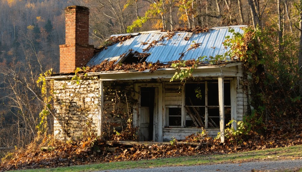
Rush Historic District: Where Vines and Trees Claim Abandoned Storefronts
When zinc prices collapsed after World War I, Rush’s fate was sealed—a mining boomtown that had claimed the title of Arkansas’s most prosperous city per capita in 1916 would become a monument to abandonment within two generations.
You’ll find the Taylor-Medley General Store and Rush Blacksmith Shop slowly surrendering to vines and encroaching forest, their 1920s craftsmanship gradually disappearing beneath nature’s advance.
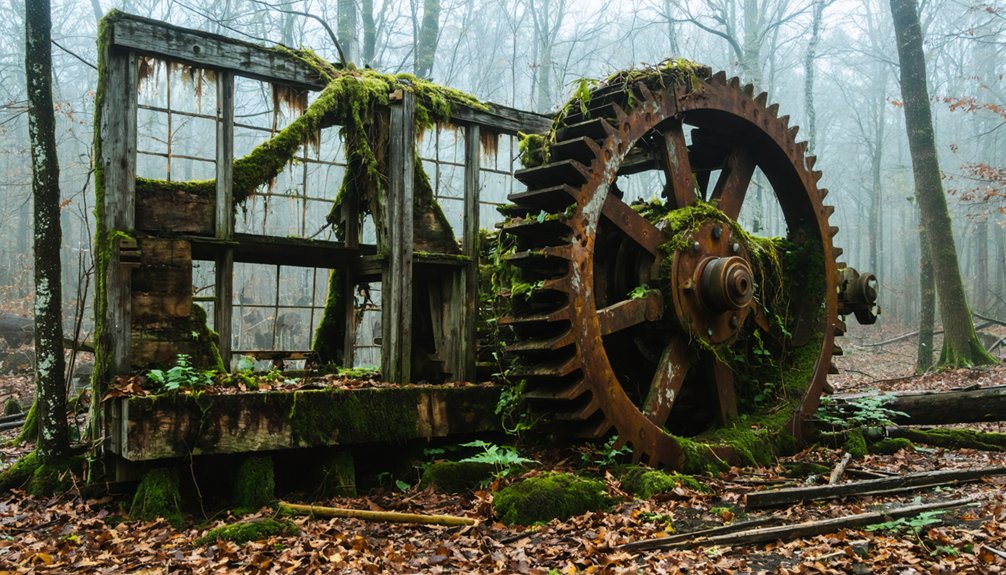
The Rush Reclamation unfolds across 1,300 acres, where flooding and arson have accelerated decay since the town’s official ghost designation in 1972. Gravity-fed tramways once transported ore from fourteen mines scattered across the hillsides to processing mills below, their exact routes now lost to the forest.
Historic Preservation efforts by the National Park Service maintain interpretive trails through this landscape of freedom lost and reclaimed, where cemetery headstones over a century old mark what civilization temporarily carved from wilderness. At its zenith, this remote zinc mining outpost supported 2,000 to 5,000 residents who created a thriving community in the Buffalo River backcountry.
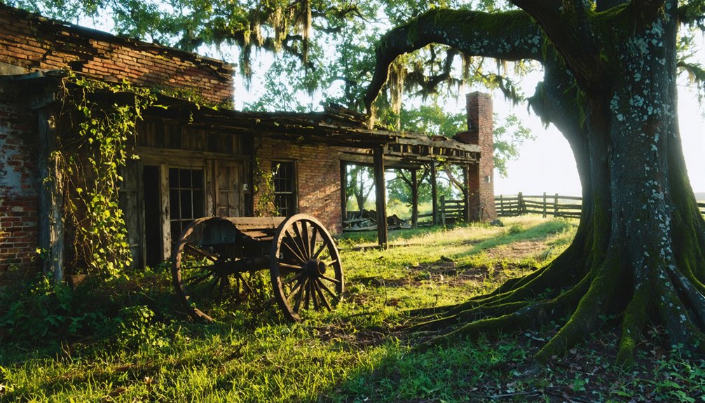
Monte Ne’s Concrete Ruins Rising From Beaver Lake’s Waters
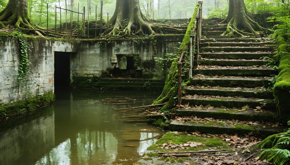
You’ll find Monte Ne’s story preserved not in dusty archives but in concrete towers that breach Beaver Lake’s surface when water levels drop.
William H. “Coin” Harvey’s turn-of-the-century resort—once featuring the world’s largest log hotels and a five-mile railroad—met its fate twice: first through the 1927 foreclosure, then permanently when the 1960s dam flooded the site.
The ruins you can explore today by kayak represent a rare case where twentieth-century abandonment preceded mid-century inundation, creating a ghost town that appears and vanishes with the seasons. Harvey was buried in a concrete vault at Monte Ne following his death in 1936, and his tomb remains among the structures partially submerged by the lake. The Monte Ne Store operated as a convenience store until 1972, serving the community as a post office, burger bar, and boat rental facility before the lake’s waters claimed the lower sections of Harvey’s abandoned resort.
Harvey’s Ambitious Resort Vision
While most entrepreneurs of the Gilded Age sought fortunes in railroads or steel, William Hope “Coin” Harvey invested his literary wealth into an audacious vision: transforming 320 acres of Ozark wilderness into America’s premier health resort.
Harvey’s ambition materialized as Monte Ne—”Mountain Water”—complete with massive log hotels featuring red tile roofs, Arkansas’s first indoor heated pool, and a dedicated five-mile rail line from Lowell.
The resort transformation included importing a fifty-foot Venetian gondola with trained local gondoliers, establishing mixed-gender swimming facilities, and constructing Missouri Row, the world’s largest log building using 8,000 logs. Harvey issued his own scrip as currency to finance the resort’s mercantile operations. Harvey’s strict character-improvement regimen ultimately alienated guests who sought leisure rather than moral reformation.
Submerged Structures Reveal Periodically
Harvey’s grand resort enjoyed two decades of prosperity before economic decline set in, yet the most dramatic transformation came decades after its abandonment.
When Beaver Lake flooded Monte Ne in 1962, the White River’s damming created an unexpected phenomenon—submerged artifacts that surface during seasonal exposure when water levels drop.
You’ll witness three key structures emerging from the depths:
- The amphitheater’s concrete skeleton reveals itself each summer
- Pyramid retaining walls stand exposed during low-water periods
- Hotel foundations and limestone bridges appear near the boat launch
The US Army Corps of Engineers manages these fluctuating levels, creating cycles where Monte Ne’s remnants periodically break the surface. The agency’s management extends beyond water control, as they hold preservation responsibilities under the National Historic Preservation Act for historic properties on their public lands.
What water preserved, it also gradually destroys—each exposure offering fleeting glimpses of Harvey’s vanished empire. Local legends persist that treasure lies buried somewhere within the submerged amphitheater’s remains.
Exploring Ruins by Kayak
Paddling toward Monte Ne’s concrete tower offers more than recreational adventure—it provides direct encounter with a preserved fragment of Progressive Era architectural ambition. Your kayak adventures navigate waters concealing William “Coin” Harvey’s 1900 resort empire, where revolutionary concrete construction methods merged with traditional hospitality.
You’ll approach the three-story Oklahoma Row tower directly from Beaver Lake’s surface, examining multi-layered graffiti marking decades of visitors since the 1960s flooding.
Historical exploration intensifies when water levels drop to 1113 feet, exposing the amphitheater where Harvey’s Liberty Party convened in 1931. The amphitheater serves as a popular fishing spot when historical low water levels make it accessible. Monitor Army Corps reports before launching—optimal conditions reveal structural foundations otherwise hidden beneath federal waters.
Though authorities began removing sections in 2023, you’re still accessing authenticated National Register sites that escaped complete submersion. Harvey’s vision included a pyramid-shaped monument designed as a time capsule, though construction halted with the 1929 stock market crash.
Old Davidsonville State Park: Walking Through Archaeological Remains
You’ll find Arkansas’s most archaeologically significant ghost town at Old Davidsonville State Park, where systematic excavations since the 1970s have revealed the complete street grid, central square, and foundation remains of the state’s first county seat.
Unlike most abandoned settlements that were built over or destroyed, Davidsonville’s 1830s desertion preserved intact artifacts and structural evidence from the earliest American frontier period in Arkansas Territory.
The town’s demise stemmed not from catastrophe but from the Southwest Trail’s rerouting by 1829, which severed Davidsonville’s commercial lifeline and rendered its federal offices obsolete within a single decade of operation.
Archaeological Discoveries and Foundations
Since 1972, archaeologists have systematically uncovered the physical remnants of Arkansas Territory’s first major settlement, transforming what was once an overgrown site into a carefully documented window into frontier life.
You’ll find hundreds of thousands of artifacts revealing the archaeological significance of this frontier crossroads, where Native American occupation dating to 4,000 BC preceded European settlement.
The discoveries span remarkable breadth:
- Domestic artifacts including wine bottles, plates, and bowls document daily frontier existence
- Spanish coins and Revolutionary War-era relics establish international trade connections
- Native American wampum beads serve as currency evidence predating territorial establishment
Through careful artifact preservation and underground studies, researchers mapped the original street grid and building foundations.
Steel-framed ghost structures now mark where the two-story courthouse and dogtrot dwellings once stood, liberating history from obscurity.
Natural Forces Caused Abandonment
While Davidsonville thrived briefly as Arkansas Territory’s first county seat, the very landscape that initially drew settlers to the Black River ultimately sealed the town’s fate.
The 1811-1812 New Madrid earthquakes altered river dynamics, intensifying seasonal flooding across the low-lying settlement. When the Southwest Trail rerouted onto higher ground after 1815, you’ll find that Davidsonville’s riverbank position became a liability rather than an asset.
The flood-prone terrain couldn’t compete with emerging towns on elevated routes. By 1829, the courthouse and federal land office relocated, leaving behind one of Arkansas’s earliest abandoned settlements.
Today, environmental reclamation has consumed most physical traces, as the Ozark-Delta borderland reclaims what frontier ambitions temporarily displaced from transitory Native American hunting grounds.
How Timber Depletion Created Arkansas’s Ozark Ghost Towns
The timber industry’s explosive growth transformed Arkansas’s Ozark region into a landscape of boom and bust, where entire communities rose and vanished within a single generation.
The “cut-out and get-out” philosophy dominated as companies extracted over two billion board feet in 1909 alone, leaving behind strings of abandoned settlements.
You’ll find this timber legacy evident in three devastating patterns:
- Company towns relocated as forests depleted—Graysonia’s 700 residents dispersed after its mill closed in 1931.
- Railroad networks abandoned—the St. Paul branch removed its tracks in 1937.
- Ghost towns emerged along former rights-of-way: Baldwin, Harris, Elkins, Durham, Thompson, Cross, Delaney, Patrick, Combs, Dutton.
The environmental consequences proved equally catastrophic—shallow Ozark soils eroded rapidly, exposing bare rock and choking streams with debris.
Pettigrew: From 1,400 Residents to Complete Abandonment
At its peak in the early 1900s, Pettigrew’s 1,400 residents outnumbered even the county seat of St. Paul, which recorded just over 1,000 in 1900.
This Madison County settlement thrived as Arkansas’s “Hardwood” center, where abundant timber resources fueled prosperity along the White River.
Pettigrew history demonstrates how quickly frontier communities could rise and fall—the town’s economic foundation crumbled when timber decline eliminated its primary industry.
The Great Depression deepened the hardship, but the railroad’s cessation on July 31, 1937 delivered the fatal blow.
Within years, you’d find complete abandonment where bustling commerce once flourished.
Today, Pettigrew stands as an unincorporated community with zero permanent residents, its structures reclaimed by Ozark wilderness—a stark reminder of resource dependency’s consequences.
Pinnacle Springs: When Bathhouses and Buildings Vanish Without Trace
Unlike Pettigrew’s timber-driven economy, Pinnacle Springs in northern Faulkner County built its fortunes on an entirely different natural resource—mineral water that promised miraculous cures but delivered only disappointment.
When Jeff Collier discovered these unusual-tasting springs in 1880, developers quickly transformed 360 acres into a booming resort town.
Pinnacle Springs history reveals an explosive growth from 1881-1886, featuring:
- Two hotels (Pinnacle House with 40 rooms and Park House)
- Twelve bathhouses serving 13 different springs
- Eight stores, a skating rink, cotton gin, and Arkansas Christian College
However, when the water failed to cure diseases and the town attracted unsavory characters, collapse came swiftly.
By 1900, abandoned buildings had burned or been dismantled.
Today, you’ll find only faint foundation traces hidden in undergrowth—freedom from civilization reclaimed by nature.
The Disappearing Architecture of Bear, Graysons, and Paraclifta
While Pinnacle Springs vanished after water cures failed to materialize, Bear’s disappearance followed an equally devastating revelation—the complete absence of precious metals that had sparked its 1880s boom.
State geologist John Casper Branner’s 1888 survey exposed the Lost Louisiana Mine as fraudulent, collapsing Bear’s economy overnight.
You’ll find the Ouachita Mountains have reclaimed what was once a town with newspapers, telephone exchanges, and bustling businesses.
Today’s lost architecture exists only in land records and faded plats.
Graysonia and Paraclifta met similar fates, though their specific economic triggers remain obscure.
Post office closures sealed their doom in the 1890s.
You’re left searching undergrowth for ghostly remnants—foundations and footings barely detectable beneath forest regrowth, evidence of nature’s efficient erasure of human ambition.
Calico Rock: a Living Town With Abandoned Pockets
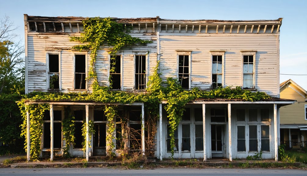
Not all Arkansas ghost towns surrender completely to oblivion. You’ll find Calico Rock thriving with 1,500 residents while harboring America’s only authentic ghost town within living city limits.
East Calico’s ghostly allure draws you through vine-covered structures where nature reclaims what economic shifts abandoned.
Where crumbling walls meet creeping vines, East Calico stands frozen—a testament to economic forces that can hollow out entire communities overnight.
The town’s historical significance emerged from:
- Transportation hub dominance – Missouri Pacific Railroad tracks and steamboat landings made it Izard County’s largest settlement in the early 1900s.
- Economic transformation – Train service cuts in the 1960s triggered mass exodus and business closures.
- Peppersauce legacy – Rowdy taverns along Calico Creek served moonshine until the county went dry in 1943.
You’re free to explore twenty abandoned structures—from the 1920s jail to the hotel sprouting saplings—without fences restricting your journey through this preserved, haunted landscape.
Nature’s Timeline for Reclaiming Human Settlements
When human footsteps cease echoing through streets and doorways, nature’s patient dismantling begins with remarkable consistency.
You’ll witness climbing vines adorning walls within a single decade, transforming brick facades into viridescent tapestries. Houtouwan village demonstrates this nature’s timeline—plants reclaimed surfaces in fewer than thirty years after 1990s abandonment.
The reclamation process accelerates through multiple vectors: moss coats structures shortly after desertion, while high humidity fosters microclimates where ferns penetrate crumbling architecture.
In desert climates, sand operates differently—Kolmanskop’s dunes swallowed entire houses within decades as coastal winds reclaimed mining settlements.
Dense vegetation ultimately erases human traces completely, with rainforest overtaking ancient sites and wild animals inhabiting former dwellings.
You’re observing nature’s methodical restoration of territories temporarily borrowed by civilization.
Frequently Asked Questions
Can Visitors Legally Explore Abandoned Buildings in Arkansas Ghost Towns?
No, you can’t legally explore abandoned buildings without permission. Urban exploration of Arkansas ghost towns risks trespassing charges regardless of vacancy. Historical records show property owners retain rights, making legal implications serious for unauthorized entry seekers.
What Wildlife Species Commonly Inhabit Reclaimed Ghost Town Structures?
You’ll find bird species dominating these ruins, with historic records showing 60% of urban wildlife now reclaiming abandoned structures. Bats, raccoons, and deer freely roam former settlements, transforming human spaces into autonomous natural habitats.
Are There Guided Tours Available for Arkansas Ghost Town Locations?
Arkansas currently lacks guided explorations specifically for abandoned ghost towns reclaimed by nature. Existing tours focus on populated historic districts’ paranormal activity rather than documenting the historical significance of uninhabited settlements where you’d find authentic architectural decay and wilderness reclamation.
How Do Property Ownership Laws Apply to Abandoned Ghost Towns?
Property rights in ghost towns remain with original owners or heirs unless you’ve maintained continuous possession for seven years. Abandoned properties don’t automatically become public—you’ll need adverse possession claims or tax sale acquisitions to establish legitimate ownership.
What Safety Precautions Should Visitors Take When Exploring Ghost Towns?
You’ll need essential safety gear like respirators and sturdy boots, while maintaining wildlife awareness for snakes and insects. Historical records reveal these precautions weren’t mere suggestions—they’ve prevented serious injuries throughout decades of documented explorations.
References
- https://everafterinthewoods.com/forgotten-ghost-towns-in-arkansas-that-are-eerially-scenic/
- https://www.thetravel.com/ghost-towns-in-arkansas/
- https://www.axios.com/local/nw-arkansas/2024/01/02/arkansas-ghost-towns-mapped
- https://aymag.com/arkansas-backstories-ghost-towns/
- https://www.bbcearth.com/news/abandoned-places-reclaimed-by-nature
- https://www.youtube.com/watch?v=dq6t7q6YjpQ
- https://www.uaex.uada.edu/environment-nature/musings-on-nature-blog/posts/ghost-towns.aspx
- https://en.wikipedia.org/wiki/List_of_ghost_towns_in_Arkansas
- https://www.nps.gov/articles/rush-historic-district-500856.htm
- https://www.barefoottraveler.com/rush.html