You’ll find over two dozen documented ghost towns across Illinois where nature has steadily reclaimed what floods, economic collapse, and railroad abandonment left behind. Old Shawneetown’s 1937 flood forced complete relocation, leaving only an 1839 bank building among reclaimed bottomlands. Cairo’s population plummeted from 15,000 to 2,000 as river commerce died and racial tensions accelerated decline. Brownsville’s unstable coal mines created lasting scars now hidden beneath vegetation, while Tuscumbia’s 54 platted lots have surrendered entirely to dense brush along the Illinois River. The forces that erased these communities reveal patterns still shaping rural America today.
Key Takeaways
- Old Shawneetown was abandoned after the 1937 flood, leaving only the 1839 Greek Revival bank building standing.
- Tuscumbia’s 54 platted lots have vanished beneath dense brush along the Illinois River, with only a cemetery remaining visible.
- Progress Cemetery sprawls across overgrown terrain with disappearing markers, now serving wildlife rather than human residents on deteriorating roads.
- Brownsville’s unstable mining conditions from room-and-pillar methods led to abandonment, creating lasting landscape impacts from underground collapse.
- Cairo’s urban decay intensified after economic collapse, though the town remains on the National Register of Historic Places.
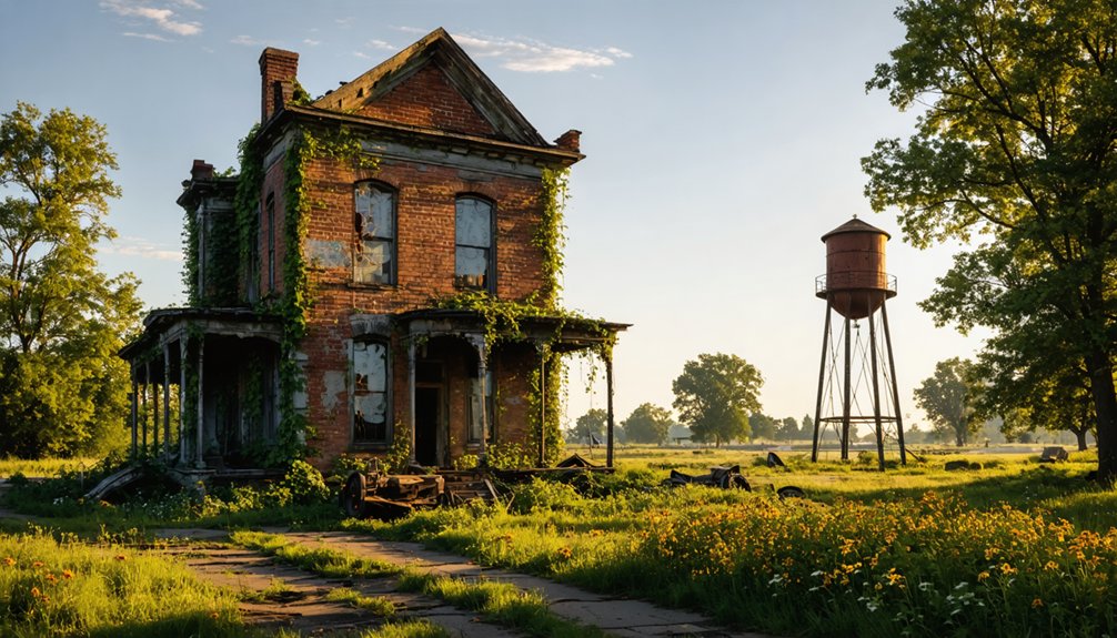
Old Shawneetown: When the River Won
Founded by Shawnee Native Americans along the Ohio River in 1793, Old Shawneetown rose to become one of Illinois’s most important commercial centers before the water that made it prosperous ultimately destroyed it.
You’ll find river history written in its abandoned streets—from Northwest Territory capital to thriving port with 1,863 residents by 1914. Salt mines and coal fed its economy while federal land offices administered westward expansion. The town once bustled with 60 businesses including general stores, restaurants, and blacksmiths.
The 1937 flood changed everything, rising two stories high and forcing complete town relocation three miles inland. By 1956, the split became official: Old Shawneetown remained as a ghost town of 193 souls, while New Shawneetown claimed 1,239.
Today, only the Greek Revival bank building from 1839 survives as evidence of a community that refused government control but couldn’t refuse nature’s power. The building stands on a high sandstone basement, originally designed to protect against the river’s inevitable floods.
Cairo: A River Town Frozen in Time
You’ll find Cairo at one of America’s most strategic locations—the confluence of the Mississippi and Ohio Rivers—yet this geographic advantage ultimately couldn’t save it from abandonment.
The town that peaked at 15,000 residents in the 1920s has dwindled to roughly 2,000, leaving behind decaying Victorian mansions, empty commercial buildings, and overgrown streets that testify to its former prosperity.
What remains is a physical archive of economic collapse and racial violence, where nature gradually reclaims structures that once served a thriving river port.
Along Commercial Avenue, the abandoned theaters and hospitals stand as hollow monuments to Cairo’s days as a vital steamboat port and county seat.
The entire town is now listed on the National Register of Historic Places, preserving the memory of both its strategic importance during the Civil War and its tragic decline.
Rivers Meet, Town Declines
At the confluence of the Mississippi and Ohio Rivers, Cairo’s geographic positioning once promised to transform this southernmost Illinois settlement into a major commercial powerhouse. By 1890, seven rail lines converged here, supporting 6,300 residents who thrived on steamboat and railroad traffic. The peak came in 1920 with 15,203 residents.
Then river commerce collapsed. The 1905 railroad bridge constructed north of Cairo eliminated ferry services, while Thebes diverted traffic away entirely. You’d watch as shipping industries vanished, taking jobs with them.
The 1937 flood forced complete evacuation, accelerating historic decline already underway. Despite its strategic importance as Fort Defiance during the Civil War, when it served as a Union naval base and supply depot, Cairo could not recover from these economic setbacks. Racial tensions during the mid-1960s protests following the alleged police murder of a young Black soldier further destabilized the community. By 2020, only 1,733 residents remained in what’s now a boarded-up shell—a stark reminder that geographic advantage alone can’t sustain a community when transportation patterns shift.
Overgrowth Consumes Historic Structures
Walking through Cairo’s downtown today, you’ll encounter block after block of crumbling brick facades and plywood-covered windows—physical evidence of a collapse that transformed a once-thriving river port into what preservationists now document as one of America’s most intact examples of urban abandonment.
The urban decay intensified after Interstate 57 bypassed the city, triggering cascading business closures and population flight. Nature’s reclamation accelerated when the 2011 floods destroyed nearly 100 residences, leaving vacant lots where vines and saplings now flourish unchecked. The town’s infrastructure bears scars from racial tensions and riots in the early 1900s, including public lynchings that significantly damaged buildings and drove population decline.
Without maintenance funds, the city watched its last grocery store close in 2015, while housing projects stood condemned until federal demolition in 2017. The Gem Theatre, once a centerpiece of Cairo’s entertainment district, now stands with collapsed ceilings and vegetation creeping through shattered windows, symbolizing the broader architectural decay across the abandoned downtown.
Brownsville: Coal’s Forgotten Legacy
The convergence of salt springs and coal seams along the Big Muddy River created Brownsville’s brief moment in Illinois history, though few today remember its name.
Dr. Conrad Will’s 1814 salt operation sparked settlement, earning the town county seat status by 1816.
Coal extraction transformed this frontier outpost into an industrial hub by mid-century, shipping black diamonds via railroad to Chicago and St. Louis.
Mining communities flourished through boom years, drawing European and Russian immigrants to work underground.
The room-and-pillar method extracted massive quantities while leaving unstable voids beneath the earth.
Workers endured ten-hour days in dangerous tunnels with low ceilings, breathing stale, dusty air that caused Black Lung disease.
By 1990, 5.5 billion tons had been removed across 1,150 square miles of undermined Illinois landscape.
The abandoned mines left unstable conditions that property owners still face generations after mining companies ceased operations.
Brownsville’s abandoned tunnels now collapse silently, reclaimed by nature’s patient advance over human ambition.
Tuscumbia: Where the Illinois River Meets Decay
You’ll find Tuscumbia’s story begins in 1837 as an essential stagecoach stop along the Illinois River, where Wade Hampton’s plat map promised prosperity through river commerce and overland trade.
Yet the very waters that sustained it—combined with the railroads that bypassed it in the 1860s—sealed its fate by 1855, when the post office closed and residents abandoned their log cabins.
Today, overgrown remnants along the riverbank mark where 54 platted lots once anticipated a future that transportation shifts and economic realities rendered impossible.
Stagecoach Stop Turned Ghost
When Wade Hampton platted fifty-four lots along the Illinois River on March 2, 1837, he envisioned Tuscumbia—named after Cherokee Chief Tashka Ambi—as a thriving commercial gateway in Bernadotte Township.
The stagecoach significance established this settlement as a crucial transit point where westward-bound settlers met river commerce.
For two decades, the community embodied frontier independence:
- Isaac Howard taught children in a log schoolhouse with greased paper windows
- Merchants supplied prairie-crossing settlers with essential goods
- Farmers shipped grain downriver to distant markets
- The post office connected isolated homesteaders to civilization
Floods and Railroad Ruin
By 1855, Tuscumbia’s streets had emptied—not from a single catastrophic event, but from the slow strangulation of economic irrelevance.
You’d find the schoolhouse shuttered, the post office abandoned, while river commerce that once sustained the community withered without warning.
When railroad routes pierced Illinois in the 1860s, engineers chose paths that bypassed Tuscumbia entirely, sealing its fate retroactively.
The flood impact from the Illinois River compounded the town’s isolation, transforming what remained into a waterlogged memory.
Merchants couldn’t compete against towns with rail access, and families drifted toward prosperity elsewhere.
Today, you’ll discover only crumbling structures and a cemetery marking where Tuscumbia stood—a reflection of how transportation networks determined which settlements survived and which returned to prairie.
Overgrown Riverbank Remnants Remain
Along the muddy banks where the Illinois River curves through Fulton County, Tuscumbia’s physical traces have surrendered to vegetation and time.
This 1837 platted settlement, once bustling with stagecoach travelers and river traders, now exists only as overgrown history marked by a solitary roadside sign off Bernadotte Blacktop.
You’ll find nature’s reclamation complete at this riverside ghost town:
- Dense brush conceals where 54 platted lots once promised prosperity
- The cemetery stands as the sole visited reminder of Tuscumbia’s inhabitants
- River commerce routes disappeared beneath encroaching wilderness
- Log schoolhouse foundations vanished into earth decades ago
Progress: Hidden Within the Wildlife Refuge
Deep within the Crab Orchard National Wildlife Refuge, Progress, Illinois stands as a demonstration to the impermanence of rural settlements in southern Illinois.
You’ll find Progress Cemetery sprawling across overgrown terrain, its markers gradually disappearing beneath encroaching forest vegetation. The abandoned infrastructure tells its own story—Progress Lane and deteriorating paved roads wind through wilderness where homes once stood.
The refuge’s protected status preserves this ghost town from modern development while simultaneously allowing nature’s complete takeover.
If you’re hiking the River to River Trail near SIU-C’s Touch of Nature property, you’ll encounter these remnants firsthand. Graffiti-marked structures and crumbling pathways offer tangible evidence of a community that chose—or was forced—to surrender to the surrounding landscape.
The site now serves wildlife rather than human residents.
Why Illinois Towns Vanish Into the Wilderness

When transportation networks shift, entire communities lose their economic foundations and begin their slow march toward abandonment.
You’ll find this pattern repeated across Illinois, where industrial decline and economic migration emptied thriving towns within decades.
The evidence reveals multiple catalysts:
- Railroads replaced river transport in Griggsville Landing, rendering docks and warehouses obsolete
- Coal mine closures in Eldred forced miners with limited transferable skills to relocate
- Racial tensions in Cairo during the 1960s accelerated population loss by 90%
- Repeated flooding made infrastructure repairs cost-prohibitive for already struggling communities
East St. Louis exemplifies this collapse—from bustling industrial center to America’s fourth most abandoned city, with 698 vacant structures and home values at $47,500.
Nature now reclaims what people built, transforming streets into overgrown wastelands.
Frequently Asked Questions
Are Visitors Legally Allowed to Explore These Abandoned Ghost Town Sites?
You’ll find legal urban exploration opportunities at designated public sites with historical significance, like wildlife refuge bunkers and marked trails. However, you’re restricted from fenced government property and private land. Always verify ownership and posted boundaries before exploring.
What Wildlife Species Now Inhabit These Former Illinois Communities?
You’ll find diverse bird species like cerulean warblers and wild turkeys reclaiming these sites, alongside growing deer populations. Endangered timber rattlesnakes, four-toed salamanders, and occasionally black bears now roam freely through abandoned Illinois communities.
Can Artifacts or Historical Items Be Removed From Ghost Town Locations?
Hold your horses—you can’t legally remove artifacts from ghost towns on public lands without permits. Artifact preservation laws protect items of historical significance, requiring you to report finds to authorities rather than collecting freely, regardless of abandonment.
Which Illinois Ghost Town Is Easiest to Access for Beginners?
Joliet Iron Works offers you the best beginner accessibility among Illinois’s popular ghost towns. You’ll find legal, self-guided exploration without trespassing concerns, with clearly marked trails leading through historic industrial remains and surrounding farm foundations.
Are Any Preservation Efforts Underway to Protect These Historical Sites?
You’ll find preservation efforts aren’t just fighting ghosts—they’re battling time itself. Despite preservation challenges, organizations like Landmarks Illinois advocate for these sites’ historical significance through National Register listings, adaptive reuse projects, and conservation district partnerships protecting Illinois’s vanishing communities.
References
- https://everafterinthewoods.com/8-forgotten-ghost-towns-in-illinois-that-are-quietly-fascinating/
- https://steemit.com/life/@dmilash/the-town-that-time-forgot-incredible-photos-show-how-nature-is-reclaiming-the-eerie-near-abandoned-city-of-cairo-illinois-and
- https://www.youtube.com/watch?v=pLnLSAREPA0
- https://www.youtube.com/watch?v=93k0qtvzkn4&vl=en-US
- https://www.bbcearth.com/news/abandoned-places-reclaimed-by-nature
- https://drloihjournal.blogspot.com/p/lost-towns-of-illinois-series.html
- https://www.freakyfoottours.com/us/illinois/
- https://www.youtube.com/watch?v=l_AceTfnfks
- https://en.wikipedia.org/wiki/List_of_ghost_towns_in_Illinois
- https://sah-archipedia.org/buildings/IL-01-059-0029