You’ll find Louisiana’s ghost towns rapidly disappearing beneath cypress swamps and coastal marshes, with over a dozen documented settlements consumed by nature since the early 1900s. Sawmill communities like Fullerton now lie beneath wetland vegetation after lumber companies cleared 70% of pine forests, while coastal towns such as Burrwood have been completely submerged by rising waters and subsidence. Louisiana loses one football field of land every 100 minutes—2,006 square miles since 1932—with abandoned settlements from hurricanes, industrial extraction, and ecological collapse revealing how environmental forces systematically erase human habitation.
Key Takeaways
- Fullerton and Alco were abandoned sawmill towns after lumber companies cleared 70% of Louisiana’s pine forests by the 1920s.
- Burrwood completely disappeared underwater due to storm surges and coastal subsidence, with no trace remaining of the settlement.
- Ruddock was abandoned after a 1915 hurricane, leaving only overgrown vegetation where the community once stood.
- Ghost forests with skeletal cypress stands mark areas where marshland reclamation and saltwater intrusion destroyed coastal ecosystems.
- Louisiana loses one football field of land every 100 minutes, totaling over 2,006 square miles since 1932.
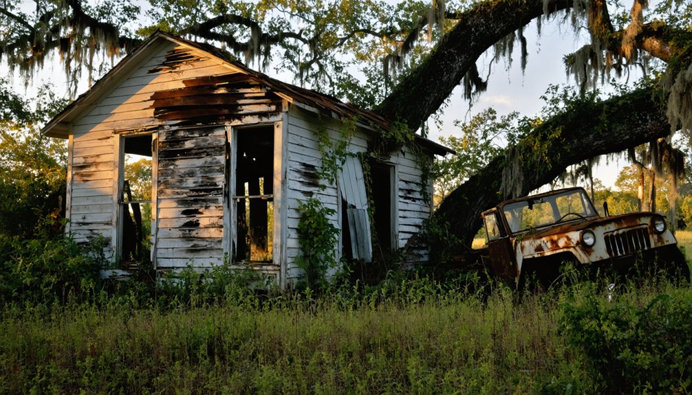
The Sawmill Communities Left Behind in Louisiana’s Forests
The whine of sawmill blades once echoed through Louisiana’s pine forests, creating prosperous communities that vanished as quickly as the timber they consumed.
You’ll find these forgotten settlements scattered across the state’s wilderness—places like Fullerton, where 5,000 residents lived with electricity and running water in 1907, or Alco, supporting over 1,000 workers in company-owned housing.
The sawmill legacy reveals a brutal economic pattern: lumber companies built entire towns, harvested surrounding forests, then abandoned everything.
By the late 1920s, they’d cleared 70 percent of Louisiana’s pine forests.
Fullerton’s longleaf pine lumber was shipped overseas to help rebuild Europe following World War One, fueling the mill’s brief prosperity.
Workers lived in company-owned homes and shopped at general stores, creating vibrant communities with schools, social gatherings, and local traditions before economic collapse forced families to relocate.
Today, the timber town remnants consist of overgrown mill sites and lonely cemeteries—like Alco’s cemetery near the old mill, receiving its last burial in 1970, standing as silent testimony to communities erased by resource extraction.
Coastal Settlements Erased by Hurricanes and Floods
Louisiana’s coastal communities have faced catastrophic destruction from hurricanes and flooding throughout the 19th and 20th centuries, forcing entire populations to permanently abandon their settlements.
You’ll find that places like Burrwood and Pecan Island represent deltaic communities erased by storm surges and rising waters, their physical landscapes fundamentally altered beyond recovery.
Burrwood experienced environmental disasters, including devastating hurricanes in 1917 and 1965, that contributed to its gradual disappearance along the Gulf of Mexico.
Bayou Corne transformed into a ghost town after a 2012 sinkhole disaster caused permanent evacuation of residents due to a collapsed underground salt dome.
These historic destruction events demonstrate how hurricane impacts combined with coastal subsidence created irreversible displacement, transforming thriving ports and fishing villages into submerged archaeological sites.
Historic Hurricane Destruction Events
Since the earliest days of European settlement, catastrophic hurricanes have repeatedly erased entire communities from Louisiana’s vulnerable coastline, transforming thriving settlements into uninhabited wastelands within hours.
The 1722 storm demolished St. Louis church and flooded the German Coast, while back-to-back hurricanes in 1778-1779 obliterated La Balize fort entirely.
You’ll find the deadliest hurricane impacts occurred in 1856 at Isle Derniere, where 150 mph winds and a 13-foot surge killed 218 people, and in 1893 at Cheniere Caminada, claiming 2,000 lives.
Isle Derniere was a prosperous resort island featuring 100 summer homes and Muggah’s Hotel, which offered visitors a restaurant, ballroom, and various recreational activities before the hurricane’s devastation.
The 1812 storm submerged New Orleans in fifteen feet of water, killing one hundred people and causing $6 million in damages.
Holly Beach demonstrates failed coastal resilience—leveled three times since 2005, causing Cameron Parish’s population to plummet 33%.
These disasters reveal nature’s absolute dominance over humanity’s coastal ambitions, leaving only ghost towns as warnings.
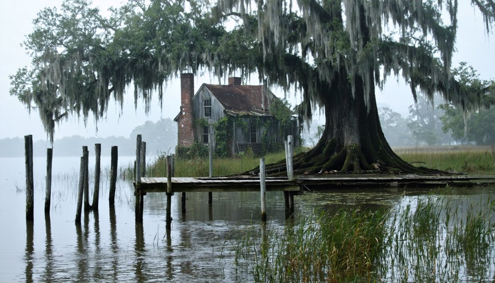
Deltaic Communities Lost Forever
Beyond the dramatic destruction wrought by individual storms lies a slower, more insidious process that has permanently erased entire deltaic communities from Louisiana’s coastline.
You’ll find Burrwood Submersion completely vanished beneath advancing waters, its 1,000 residents scattered as subsidence consumed their settlement near the Mississippi River’s southern terminus.
Pointe Aux Chenes exists now only as skeletal tree carcasses and a solitary cemetery cross marking where schools and homes once stood.
These lost communities represent more than statistical casualties—they’re evidence of systematic coastal abandonment driven by erosion, industrial development, and failed restoration priorities.
Isle Dernier’s transformation from pelican sanctuary to pipeline corridor exemplifies how energy extraction accelerated land loss.
The expansion of the oil and gas industry created thousands of miles of pipelines and navigation canals that increased saltwater intrusion, transforming freshwater communities into saline environments hostile to their existence.
Ruddock in St. John the Baptist Parish met its end when a hurricane struck in 1915, leaving only overgrown vegetation and rotted wood where buildings once stood, though the exit sign on I-55 still marks its ghostly presence.
When CPRA canceled the Mid-Barataria Sediment Diversion in 2025, they sealed the fate of remaining settlements facing inevitable submersion.
Population Displacement and Relocation
When Hurricane Katrina struck in 2005, it displaced 1.5 million people across the Gulf Coast and triggered the permanent relocation of nearly one-fifth of New Orleans’s residents—a demographic collapse that transformed displacement from temporary emergency into permanent exodus.
The pattern intensified with subsequent storms:
- Hurricane Rita displaced 37,000 Louisiana residents and damaged 110,000 houses.
- Hurricanes Delta and Laura in 2020 forced coastal communities inland toward Lake Charles.
- CPRA projections warn 1.2 million Louisianans—equivalent to New Hampshire’s population—face flooding risk by 2050.
Southern Louisiana now pursues urban adaptation through strategic resettlement, directing hundreds of thousands from vulnerable coastal zones to twelve designated receiving communities. Recipient cities often arrive unprepared for the sudden influx of displaced residents requiring housing, schools, and social services.
Plaquemines Parish exemplifies this demographic transformation, with projected population in 2050 reaching only 22,373—a significant decline from 2000 levels despite shifting age distributions.
This forced migration represents population resilience planning at unprecedented scale, as entire settlements vanish beneath rising waters.
Post-Katrina Vacancy and Urban Abandonment in Orleans Parish
Hurricane Katrina’s 2005 landfall transformed New Orleans into a landscape of abandonment unprecedented in modern American urban history.
You’ll find over 73,000 vacant properties throughout Orleans Parish, with the city’s 13.10 percent vacancy rate ranking fifth nationally. More striking: 79 percent of these units have stood empty for three years or longer, creating pockets of profound urban decay across neighborhoods.
The recovery’s uneven nature accelerated systemic abandonment. While federal resources poured in, disinvestment patterns deepened.
Federal aid flowed selectively through New Orleans, paradoxically intensifying the same abandonment patterns it promised to reverse.
You’re looking at more than 20,000 blighted residential units—structures posing safety hazards that threatened the city’s fragile renewal. Heirs property complications, title disputes, and missing documentation kept families from reclaiming homes.
Yet enforcement initiatives, demolition tracking, and streamlined permitting processes now combat this vacancy crisis, returning properties to commerce and community control.
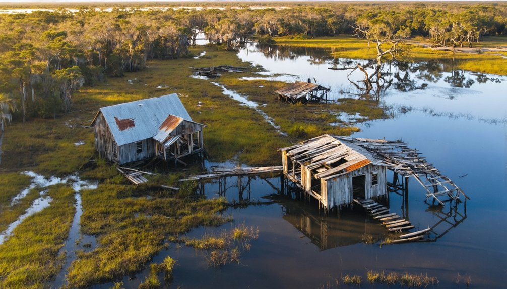
Deltaic Plain Communities Swallowed by Marshlands
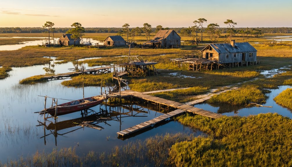
You’ll find the deltaic plain’s abandonment pattern differs markedly from urban post-Katrina vacancy—here, settlements disappeared gradually as the Mississippi River shifted course and marshlands reclaimed inhabited ground.
Archival records document how communities like Mauvais Bois and Manila transformed from farmsteads into waterlogged terrain, forcing residents to migrate toward higher levee ridges between the 1920s and 1950s.
These vanished towns reveal how deltaic subsidence and hydrological changes created ghost landscapes long before hurricanes accelerated coastal land loss.
Abandoned Farmsteads and Settlements
The Mississippi River Delta‘s relentless transformation has consumed entire farming communities that once thrived on its fertile sediments.
You’ll find abandoned structures now submerged beneath advancing waters, where sediment deprivation and subsidence have converted productive farmsteads into open water. The delta’s natural processes show no mercy to human settlements.
Three forces driving this transformation:
- Levees blocking sediment delivery – preventing wetland replenishment while land sinks
- Barrier island erosion – exposing delta plains to waves and storm surges at 20 meters annually
- Canal networks – disrupting hydrology and accelerating subsidence into open water
Since the 1930s, over 2,000 square miles have vanished, with nature’s resurgence claiming what communities built.
The projected loss of 1,800 km² by 2050 guarantees more settlements will disappear beneath Louisiana’s expanding waters.
Population Migration to Levees
When catastrophic storms struck Louisiana’s coast in 1909 and 1915, they triggered a migration pattern that’d reshape deltaic settlements for generations. You’ll find the evidence in abandoned sites like Leeville, where survivors fled to inland levee communities—Golden Meadow, Cut Off, and Larose.
Isle de Jean Charles lost 779 residents in 1893, forcing survivors toward mainland protection.
These levee migration corridors offered temporary refuge from storm surge, yet created new vulnerabilities.
Population shifts concentrated settlements along Bayou Lafourche’s elevated banks, where Mississippi distributary flows and poor drainage intensified flooding.
The South Lafourche Levee District constructed protective systems independently, but chronic bayou overflows persisted.
You’re witnessing how protective infrastructure paradoxically trapped communities between surge threats and inland inundation, ultimately abandoning coastal settlements to encroaching marshlands.
Mauvais Bois and Manila
Marshland reclamation has erased Mauvais Bois and Manila so completely that no structures, signage, or physical traces remain on Louisiana’s deltaic plain.
You’ll find these Houma tribal settlements existed within a 25-mile radius of Point Barre, supporting hunters, trappers, and fishermen through the early 20th century before environmental destruction accelerated their demise.
The Manila Community and Mauvais Bois vanished through three industrial impacts:
- Canal construction diverted freshwater and sediment, allowing saltwater intrusion that killed protective marshes.
- Oil and gas extraction caused subsidence beneath fragile estuary settlements.
- Ongoing erosion continues washing away tribal lands daily.
Referenced in Grevemberg’s 1765 Fausse Pointe grant, Mauvais Bois harbored displaced Houma who sought coastal isolation.
Without federal recognition, their settlements now lie beneath advancing waters—another freedom lost to environmental exploitation.
How Coastal Erosion Is Consuming Louisiana’s Ghost Towns
Louisiana’s coastline faces an unprecedented crisis, losing approximately one football field of land every 100 minutes—a rate that translates to 25-35 square miles annually.
You’re witnessing entire settlements vanish as oil and gas infrastructure, levees, and canals accelerate saltwater intrusion. Since 1932, over 2,006 square miles have disappeared beneath the Gulf’s waters.
Ghost towns that survived hurricanes and economic collapse now face nature’s relentless advance.
Terrebonne and Lafourche Parishes erode at 75 square kilometers yearly, threatening submersion within decades. Mississippi River diversions have starved wetlands of sediment-building capacity, while subsidence compounds the destruction.
Without aggressive coastal restoration and reformed land management, you’ll watch Louisiana’s cultural heritage dissolve into the sea.
Communities that once thrived are becoming underwater archaeological sites.
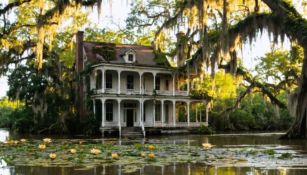
Plantation Villages Preserved as Historical Remnants
While coastal erosion consumes Louisiana’s inhabited settlements, inland plantation complexes stand frozen in time as architectural witnesses to the state’s antebellum past.
These preserved villages reveal the brutal economic machinery that powered the state’s agricultural empire through enslaved labor.
Three plantation complexes exemplify historical preservation through their remaining structures:
- Laurel Valley Plantation — America’s largest surviving sugar plantation complex with nearly 40 original buildings documenting centuries of forced labor.
- Laura Plantation — One of only 15 Louisiana sites retaining complete plantation architecture, including two slave cabins and outbuildings.
- Rosedown Plantation — A 371-acre state historic site with 13 buildings illustrating how 450 enslaved people sustained cotton operations.
You’ll find these remnants offering unvarnished archival evidence of Louisiana’s complicated history, preserved as uncomfortable monuments to human resilience and oppression.
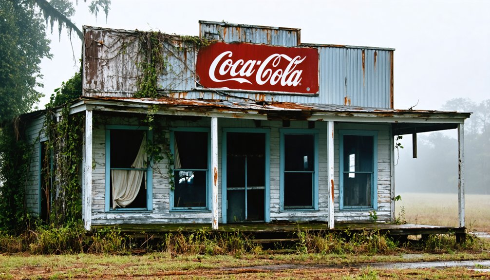
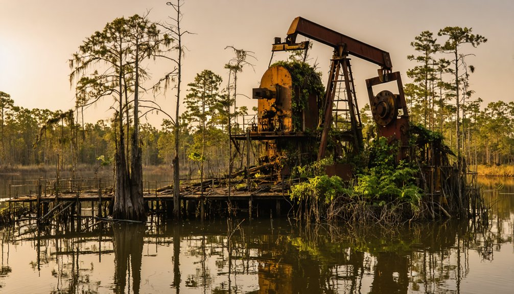
Oil Field Ghost Towns in the Wetlands
Beyond the preserved architecture of Louisiana’s plantation past lies another category of abandonment—settlements erased not by time but by industrial contamination.
You’ll find Revilletown’s ghost town history particularly devastating—founded in 1881 by formerly enslaved people along the Mississippi River, this community watched chemical plants release PVC powder that killed their gardens and poisoned their water. The 1987 Georgia-Pacific settlement relocated survivors before bulldozers destroyed everything except the cemetery.
Meanwhile, oil field contamination sprawls across Louisiana’s wetlands where thousands of miles of pipeline canals altered hydrology and accelerated erosion.
Abandoned wells and rusted flowlines leak indefinitely into marshlands. Since the 1901 Evangeline Field discovery, early operations dumped saltwater waste and petroleum across fragile ecosystems—contamination persisting decades without remediation.
Nature’s Reclamation Through Wetlands and Vegetation Growth
Where Louisiana’s abandoned settlements once stood, ghost forests now rise from poisoned ground—skeletal cypress stands bleached white by saltwater that never belonged this far inland.
You’re witnessing nature’s brutal reclamation, where Gulf waters pushed 50 miles inland by levees poisoned what overharvesting didn’t finish.
Wetland restoration efforts fight back through:
- $15.8 million invested since 2011 preserving 100,000+ acres of coastal forestland
- Hundreds of thousands of cypress seedlings planted by nonprofits in saltwater-damaged zones
- Mississippi River reconnections reversing the hydrological tampering that killed forests
Yet vegetation recovery battles seventy-five square kilometers of annual loss.
Navigation canals carved into swamps accelerated the destruction—2,000 square miles gone in a century.
Dead trees mark where freedom-seeking settlers once built communities, now drowned by man’s engineering mistakes.
Frequently Asked Questions
Can You Legally Visit or Explore Louisiana’s Ghost Towns?
You can’t legally explore Louisiana’s ghost towns without permission. Ghost town regulations require written consent from property owners before exploring abandoned sites. Trespassing carries $500 fines or six months imprisonment, restricting your access to these historically significant locations.
Are There Any Ghost Towns in Louisiana That Are Haunted?
Time’s shadows cling to Louisiana’s abandoned settlements. You’ll find haunted legends most famously at Frenier, where Julia Brown’s curse preceded the catastrophic 1915 hurricane. Survivors reported eerie encounters throughout the devastated, waterlogged remains.
What Wildlife Species Commonly Inhabit Abandoned Louisiana Settlements?
You’ll find bobcats, feral hogs, and nutria demonstrating remarkable wildlife adaptation in abandoned settlements. These species maintain ecological balance through natural colonization, supported by archival evidence showing mammals reclaiming human-free zones across Louisiana’s forgotten territories.
How Do Locals Preserve Memories of Disappeared Louisiana Communities?
You’ll find locals preserve disappeared communities through memorial events honoring founders, maintaining handwritten deeds, protecting burial grounds through legal battles, and continuing local storytelling traditions that document settlement histories despite industrial encroachment and natural reclamation.
Are Any Louisiana Ghost Towns Being Considered for Restoration?
Louisiana’s restoration projects focus on ecological recovery rather than rebuilding ghost towns. You’ll find efforts prioritizing marsh restoration and sediment diversion over historical communities, as their environmental significance now outweighs preserving former settlements’ historical significance.
References
- https://pmc.ncbi.nlm.nih.gov/articles/PMC7483120/
- https://www.geotab.com/ghost-towns/
- https://en.wikipedia.org/wiki/List_of_ghost_towns_in_Louisiana
- https://www.ezhomesearch.com/blog/ghost-towns-in-louisiana/
- https://pubs.usgs.gov/of/1983/0118/report.pdf
- https://heartoflouisiana.com/louisiana-sawmill-towns-short-life/
- https://louisianagenealogygirl.wordpress.com/2021/03/23/sawmill-towns/
- https://www.sfasu.edu/heritagecenter/9862.asp
- https://64parishes.org/lumber-king
- https://www.crt.state.la.us/Assets/OCD/hp/nationalregister/historic_contexts/The_Louisiana_Lumber_Boom_c1880-1925.pdf