Mississippi’s ghost towns follow a predictable decay pattern you’ll recognize across the state: catastrophic events like Rodney’s 1870 river shift and Civil War devastation first hollow out communities, then nature systematically erases what remains. You’re witnessing manicured lawns becoming meadows within thirty days, vines consuming homes in three decades, and buildings collapsing entirely by year fifty. Places like Logtown now host 185 bird species where 500 residents once lived, while Jackson struggles with 1,800 abandoned properties fostering wildlife corridors. Understanding this transformation reveals why some communities engineer deliberate ecological restoration.
Key Takeaways
- Rodney, Mississippi’s busiest 1860s port, became isolated after the Mississippi River shifted two miles west in 1870.
- Manicured lawns become meadows within thirty days; vines engulf homes in three decades; buildings collapse between years thirty and fifty.
- Logtown’s abandoned streetscapes now support 185 bird species, endangered gopher tortoises, and wetlands from flooded foundations.
- Maritime live oak hammocks and longleaf pine forests replace former urban sites through autonomous rewilding and prescribed burns.
- Tree roots penetrate pavement within a decade while mosses colonize asphalt cracks, eventually creating hundred-foot forest canopies.
The Rise and Fall of Rodney: Mississippi’s Most Famous Ghost Town
While most Mississippi River settlements clung to their positions along the waterway’s banks, Rodney rose to prominence through circumstances that would ultimately seal its doom.
Rodney’s greatest advantage became its fatal flaw as the Mississippi River first blessed, then abandoned the thriving port town.
You’ll find Rodney’s history reflects a dramatic arc: from the state’s busiest port between New Orleans and St. Louis in the 1860s, hosting 4,000 residents and Mississippi’s first opera house, to complete abandonment.
The river that made Rodney prosperous betrayed it when sandbars shifted the Mississippi two miles west in 1870. Railroad developers bypassed the isolated town for Fayette in the 1880s, severing its lifeline.
Governor Theodore Bilbo officially revoked Rodney’s incorporation in 1930.
The town’s prosperity attracted notable visitors including Andrew Jackson and Henry Clay, who passed through during Rodney’s antebellum heyday. Yellow fever epidemics struck in 1843 and 1847, devastating the population and foreshadowing the town’s eventual decline.
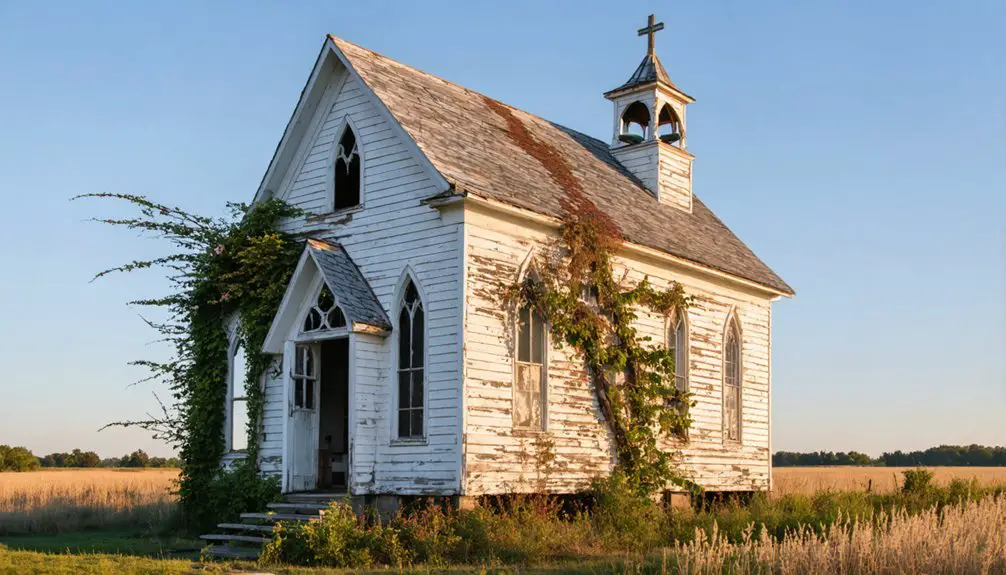
Today, ghost town legends persist among thirteen residents, haunted by an 1890 lynching victim who reportedly wanders the 200-grave cemetery behind the surviving Presbyterian church.
How War, Fire, and Economic Collapse Created Abandoned Settlements
You’ll find that Mississippi’s ghost towns didn’t emerge from a single catastrophe but from cascading disasters that systematically dismantled their economic foundations.
The Civil War‘s Union raids stripped Rodney of resources and wealth in the 1860s, while simultaneously severing the cotton trade networks that had sustained river commerce throughout the antebellum period.
When the Mississippi River shifted two miles west in 1870—just five years after the war’s end—it delivered the final blow to communities already weakened by military occupation, transforming thriving ports into isolated settlements cut off from the very waterways that had created them.
Devastating fires in 1837, 1852, and 1869 destroyed the town’s early buildings, erasing much of the physical infrastructure that merchants and settlers had invested decades building.
Rodney serves as a navigation point for understanding how multiple catastrophic events can converge to create abandonment.
Civil War’s Devastating Impact
Though Rodney once thrived as a strategic Mississippi River port fifty miles downriver from Vicksburg’s Confederate stronghold, the Civil War initiated a cascade of destruction from which the town never recovered.
Confederate cavalry’s unprecedented capture of seventeen USS Rattler sailors during church service in 1863 triggered immediate retaliation—Union gunboats shelled the town, striking the Presbyterian church and four homes.
You’ll still find a cannonball replica embedded above the church balcony, marking where congregants hid behind pews during the skirmish.
Beyond direct bombardment, passing troops stripped the area of food and livestock.
The Union military established a concentration camp in the area for formerly enslaved people during the war, adding to the region’s complex and painful Civil War legacy.
Reconstruction brought severe economic hardship, and when the 1869 railroad bypassed Rodney entirely, isolation became permanent.
River Trade Collapse
Mississippi’s river towns depended on continuous navigation, yet structural catastrophes demonstrated how quickly commerce could vanish. When Locks 26 collapsed in 1976, 100 towboats and 900 barges jammed near Alton for eight days, threatening grain elevators and halting $280,000 daily in New Orleans shipping.
You’ll find similar vulnerability in the 1973 Old River Control failure, where collapsed infrastructure risked diverting the Mississippi entirely—potentially destroying ports handling 60% of U.S. grain exports worth $295 million daily.
These economic shifts mirrored earlier railroad competition that strangled steamboat trade routes after 1847. Lead mining’s depletion and rail networks shortened profitable trips, transforming thriving river settlements into ghost towns. The crisis forced steel companies in Chicago to resort to trucking lime instead of using barges, revealing how infrastructure failures instantly severed industrial supply chains.
The Mississippi River provides drinking water to 30 million Americans, making any disruption to its flow a threat not only to commerce but to essential municipal services in river communities.
When navigation fails, commerce doesn’t relocate—it evaporates, leaving abandoned communities behind.
When Rivers Reclaim Their Territory: Flooding’s Role in Town Abandonment
You’ll find that Rodney’s final chapter was written not by gradual decline but by the catastrophic 2011 flood, which swept away most remaining structures and displaced the last holdout residents.
The floodwaters didn’t merely inundate buildings—they systematically dismantled infrastructure that had survived over a century of periodic flooding, eroding foundations and collapsing structures that had withstood the legendary 1927 and 1935 floods.
What archival records reveal is a pattern of increasing structural vulnerability: each successive flood weakened buildings beyond repair, until the 2011 event exceeded both the physical capacity of remaining infrastructure and the economic feasibility of restoration.
The 1927 disaster alone submerged one million acres under 10 feet of water, demonstrating the Mississippi River’s capacity to permanently transform entire landscapes and erase communities from the map.
Mississippi’s Prentiss faced an even more permanent fate when the Mississippi River consumed the entire town by the 1870s, transforming this once-thriving county seat into an underwater ghost town with no remains available for exploration.
Rodney’s 2011 Flood Devastation
The catastrophic 2011 flood delivered Rodney’s final blow after decades of gradual decline.
When the Mississippi River peaked at 57.1 feet at Vicksburg on May 19—surpassing the legendary 1927 flood—the already-vulnerable settlement couldn’t withstand nature’s assault.
This 500-year flood event, triggered by four April storm systems and snowmelt, released record streamflow of 2,310,000 cubic feet per second.
The deluge washed away most remaining residents and structures, accelerating urban abandonment that began when the river shifted four miles away decades earlier.
Unlike engineered systems demonstrating flood resilience through spillways and controls, Rodney possessed no such defenses.
The federal government declared 14 counties along the Mississippi River disaster areas as the flood established new record stages at both Vicksburg and Natchez.
Infrastructure Erosion and Collapse
When engineering conquers rivers through dams and levees, the unintended consequences often devastate the very communities these structures promised to protect.
You’ll find Mississippi’s ghost towns testify to failed sediment management and inadequate levee maintenance that accelerated abandonment rather than prevented it.
Consider these infrastructure failures:
- Dams reduced Mississippi River discharge from 1,200 km³ to 529 km³ annually, starving deltas of land-building sediment.
- Trapped sediment prevented natural deposition, causing deltaic floodplains to settle 0.6 to 3 meters per century.
- Louisiana lost over 2,000 square miles since the 1930s—equivalent to Delaware’s entire area.
- Wetlands vanish into open water every 100 minutes in the Mississippi Delta.
- Levees built by prisoners and slaves ultimately increased vulnerability by blocking sediment flow.
This infrastructure collapse transformed thriving river towns into abandoned ruins.
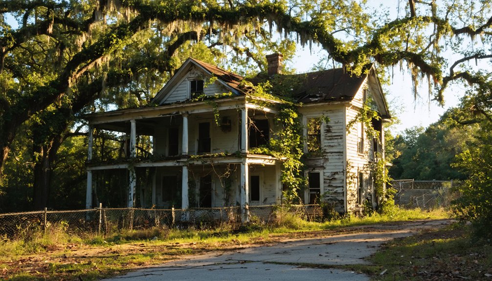
Nature’s Timeline: How Vegetation Consumes Forgotten Structures
Within weeks of human departure, nature’s reclamation launches its methodical assault on abandoned structures through a predictable yet relentless sequence.
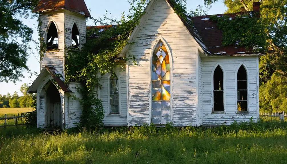
You’ll observe manicured lawns transforming into knee-high meadows within thirty days as dandelions and ragweed stake their claims. Climbing vines blanket walls next, creating vegetation sculptures from former homes—what appears centuries-old develops in under three decades.
Mosses colonize asphalt cracks while tree roots penetrate deteriorating pavement within a decade. By years thirty through fifty, buildings collapse entirely, leaving only stone outlines beneath thick canopies.
This urban wilderness timeline proves consistent: herbaceous plants establish first, followed by shrubs and vines, culminating in towering trees whose roots dismantle foundations. Century-old concrete dissolves completely, replaced by hundred-foot forest canopies reclaiming their ancestral territory.
Jackson’s Struggle With Nearly 2,000 State-Owned Abandoned Properties
You’ll find Jackson bearing a disproportionate burden—nearly 1,800 state-owned abandoned properties as of August 2024, representing 25 percent of Mississippi’s statewide total concentrated in a single city.
These deteriorating structures, 95 percent residential and acquired through twice-yearly tax sales after years of neglect, present cascading environmental and safety hazards that compound with each property added to state rolls.
The economic consequences ripple through neighborhoods as property values decline, tax bases erode, and the true scale remains masked—official counts exclude the 3-4 additional abandoned properties awaiting tax sale for every one already state-owned.
Scale of Property Abandonment
As of August 2024, approximately 1,800 state-owned abandoned properties sit within Jackson’s city limits—a staggering figure that represents nearly 25 percent of Mississippi’s 7,000 total state-owned abandoned properties statewide.
You’re witnessing urban blight at an unprecedented scale, compounded by processing delays that mask the crisis’s true magnitude:
- Properties require two to eight years before appearing on state ownership records
- Three to four additional abandoned properties exist for every one officially tracked
- The city and state combined hold 4,000 properties unsuitable for auction
- 95 percent of abandoned properties are zoned residential
- Property counts update daily as sales occur
Property restoration faces overwhelming odds when official statistics underestimate actual abandonment.
With new properties added twice yearly, this crisis demands immediate action to reclaim community independence.
Environmental and Safety Hazards
Jackson’s nearly 2,000 state-owned abandoned properties haven’t just created an economic burden—they’ve spawned a public health and safety crisis that threatens entire neighborhoods.
Urban decay manifests through overgrown lots where vermin, raccoons, and possums thrive, creating wildlife resurgence that endangers residents.
You’ll find illegal dumping at over 250 sites, with complexes like Chapel Ridge buried under trash. These properties harbor drug operations, prostitution rings, and arson risks—trespassers light fires for warmth, threatening surrounding blocks.
The city’s code enforcement teams respond to environmental hazards while police handle suspicious activity calls. But with properties clustered heavily in Wards 3 through 7, remediation efforts struggle against the scale.
Dilapidated structures near schools and churches compound the threat, transforming what should be vibrant communities into hazardous zones.
Economic Impact on Communities
Beyond the visible deterioration and safety threats, the sheer concentration of abandoned properties in Jackson has created an unprecedented economic crisis.
Holding nearly 25% of Mississippi’s state-owned abandoned properties—approximately 1,800 parcels—you’re witnessing how tax delinquency paralyzes economic revitalization.
The scope reveals systemic dysfunction:
- Pre-sale multiplier: For every state-rolled property, 3-4 additional abandoned properties await tax forfeiture
- Maintenance impossibility: Secretary of State’s office lacks resources to maintain 1,800+ parcels with daily fluctuations
- Residential dominance: 95% zoned residential, limiting commercial redevelopment potential
- Delayed intervention: Properties enter state rolls after 2-8 years of delinquency, prolonging community blight
- Persistent inventory: Biannual tax sales sustain high numbers despite active liquidation efforts
This concentration burdens Jackson disproportionately while Mississippi’s broader inventory exceeds 7,000 state-owned parcels.
The Hidden Costs of Abandonment: Property Values and Community Decline

When communities begin their decline, the economic damage extends far beyond simple population statistics—abandoned properties trigger cascading failures that hollow out entire municipal systems.
You’ll find property depreciation accelerates when vacant structures concentrate in neighborhoods, with Jackson experiencing this firsthand as 25% of Mississippi’s abandoned properties clustered within city limits.
Each burned building or overgrown lot drags neighboring values downward, creating zones where property owners can’t sell even when desperate to leave.
The costs compound relentlessly: disappearing tax revenues force service cuts, which accelerate resident flight, further weakening municipal budgets.
Crime maps reveal abandoned properties serve as criminal activity hotbeds, deepening neighborhood decline.
Community revitalization becomes nearly impossible when negative feedback loops entrench themselves, transforming once-stable areas into economically unsalvageable zones.
Lost Cemeteries: 200 Graves Disappearing Beneath Overgrowth
Across Mississippi’s landscape, over 200 documented graves have vanished beneath decades of unchecked vegetation—a crisis that mirrors the state’s broader pattern of institutional abandonment.
You’ll find forgotten histories literally buried beneath pine trees and poison ivy, where descendants’ exodus enabled systematic erasure. Cemetery preservation failures reveal how economic systems perpetuate injustice beyond death itself.
The evidence demands your attention:
- New Salem Cemetery: Abandoned in the 1930s, requiring complete body relocation after overgrowth obscured graves
- Asylum Hill Cemetery: 2,000+ souls from Mississippi State Lunatic Asylum lost to brush until 2019 legislative intervention
- Sandfield Cemetery: Columbus’s oldest African American burial ground stripped of headstones as businesses encroached
- Industrial Sites: Continental Tire, Shell Oil, and Formosa Plastics projects unearthed unmarked cemeteries during expansion
- Climate Threats: Rising waters and development erase sites omitted from historical maps
Wildlife Returns: What Moves Into Abandoned Mississippi Towns
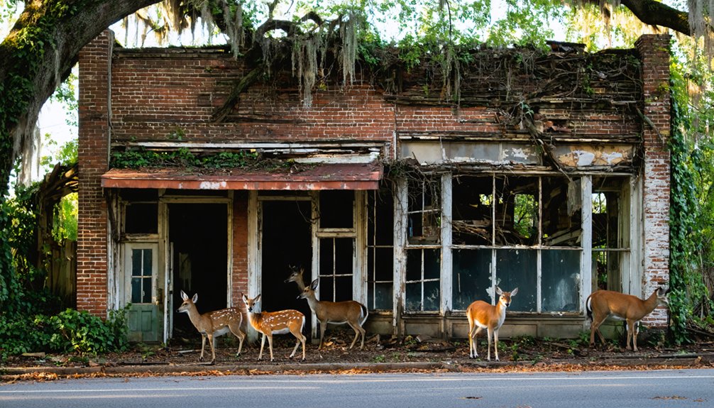
As Mississippi’s ghost towns shed their human populations, ecological succession transforms abandoned streetscapes into thriving wildlife corridors—a process documented across sites like Logtown, where 185 bird species now occupy what census records show housed 500 residents in 1900.
Where 500 people once lived, 185 bird species now thrive—nature systematically reclaiming abandoned human landscapes through documented ecological succession.
You’ll find endangered gopher tortoises reclaiming former homesites, while swallow-tailed kites patrol skies above crumbling foundations.
This wildlife migration follows predictable patterns: Rodney’s overgrown cemetery attracts reptiles seeking shelter in abandoned structures, and Rocky Springs’ Methodist Church stands amid forest reclamation.
Ecosystem restoration accelerates where mosaic wetlands replace urban footprints, creating amphibian habitats from flooded foundations.
Maritime live oak hammocks emerge naturally, while prescribed burns target longleaf pine restoration.
These autonomous rewilding processes demonstrate nature’s capacity to reclaim human spaces without intervention.
Loch Leven Island: A Model for Productive Land Reclamation
Unlike the passive rewilding occurring at Rocky Springs and Rodney, Loch Leven Island represents deliberate ecological engineering—a 6,000-acre Mississippi River floodplain where archival records trace human intervention from its 1776 formation as an oxbow through mid-19th century levee construction to its 2016 conversion into the Lower Mississippi’s largest wetland reconnection project.
You’ll find extensive wetland restoration here:
- 28 water control structures replicating natural seasonal flood pulses
- 4,500 acres enrolled in federal Wetland Reserve Program
- Excavated levee sections reconnecting river flow patterns
- Box culverts replacing restrictive barriers
- 15+ partners coordinating ecosystem services
The Piazza family’s collaboration with The Nature Conservancy demonstrates how private landowners can shift from commodity production to ecological restoration.
Bottomland hardwood forests now recover where soybeans grew, filtering nutrient runoff while accommodating Mississippi’s premier migratory waterfowl populations.
Floodplain Restoration: Turning Abandoned Spaces Into Thriving Ecosystems
While Loch Leven Island showcases successful agricultural-to-wetland conversion, the upper Mississippi River basin reveals floodplain restoration‘s darker complexities through archival forest data documenting catastrophic ecosystem collapse.
You’ll find forest cover plummeted 18% between Bellevue and Clinton, Iowa from 2010 to 2020, with dead trees now comprising 25% of remaining patches. Increased flooding since 2016 suffocates root systems, accelerating mortality while invasive grasses colonize former woodlands.
The $37 million Reno Bottoms project represents ambitious ecosystem revitalization, raising island elevations and replanting 550 acres, yet scientists can’t guarantee restored forests will survive intensifying flood cycles.
Complete floodplain restoration remains economically impossible—some sites prove too waterlogged for any intervention.
Some degraded floodplains have crossed economic viability thresholds—waterlogged beyond any restoration technique’s capacity to reverse ecological collapse.
You’re witnessing real-time uncertainty: whether nature can reclaim what climate destabilization continues destroying.
Frequently Asked Questions
Can I Legally Explore Abandoned Ghost Towns in Mississippi?
You can’t legally explore without permission, even in ghost towns. Legal considerations require identifying property owners through public records and obtaining written consent. Exploring ethics demand respecting ownership rights, regardless of abandonment status or historical significance.
How Long Does Nature Take to Completely Reclaim an Abandoned Building?
Nature’s reclamation of abandoned buildings spans decades to centuries, depending on climate and construction. You’ll see vegetation within months, structural compromise in 10-20 years, and complete forest integration after 100+ years of unimpeded growth.
Are There Any Preserved Ghost Towns in Mississippi Open to Tourists?
You’ll find Rodney’s historical preservation efforts welcoming ghost town tours year-round. Founded in 1828, it’s accessible via dirt roads off Natchez Trace Parkway, featuring two preserved churches and an overgrown cemetery you’re free to explore.
What Happened to Residents Who Left Rodney After the Floods?
Scattered like leaves, Rodney’s residents sought work elsewhere after floods devastated their town. Flood aftermath erased economic opportunities, forcing families to abandon homes. You’ll find limited archival evidence tracking where displaced residents ultimately settled in Rodney history.
Can Abandoned Properties in Jackson Be Purchased for Development?
You can purchase abandoned properties in Jackson through the city’s surplus program or tax-forfeiture sales, accessing development opportunities with proposed tax credits under House Bill 1201, though the redemption period may delay your projects considerably.
References
- https://mississippifolklife.org/articles/haunted-by-a-ghost-town-the-lure-of-rodney-mississippi
- https://www.nature.org/en-us/about-us/where-we-work/united-states/mississippi/stories-in-mississippi/loch-leven-mississippi/
- https://magnoliatribune.com/2024/09/09/city-of-jackson-has-nearly-a-quarter-of-mississippis-abandoned-properties/
- https://www.youtube.com/watch?v=9kYDx9ZR7Fo
- https://www.bbcearth.com/news/abandoned-places-reclaimed-by-nature
- https://www.mdeq.ms.gov/wp-content/uploads/2017/06/2010AnnualReport.pdf
- https://en.wikipedia.org/wiki/List_of_ghost_towns_in_Mississippi
- https://sethparker.net/rodney-mississippi-the-ghost-town-youve-probably-never-heard-of/
- https://theforgottensouth.com/rodney-mississippi-ghost-town-history-tour/
- https://backroadplanet.com/haunting-rodney-mississippi/