Over 900 abandoned Nebraska towns are gradually disappearing as nature reclaims what settlers built. You’ll find alkaline soil dissolving sod structures back into prairie, while advancing vegetation swallows communities like Alkali and Crouse. Harsh storms strip wooden buildings, and erosion transforms former streets into grasslands—settlements like Oreapolis vanished within five years. Today, scattered tombstones and cemetery records mark where thriving communities once stood, though aerial photographs and historic maps still reveal hidden foundations beneath agricultural expanses, documenting this ongoing transformation from human settlement to wilderness.
Key Takeaways
- Nebraska has over 900 abandoned towns, with concentrations in Knox County, Cass County, and Otoe County facing natural reclamation.
- Harsh weather, soil erosion, and advancing vegetation dissolve wooden buildings and sod structures back into prairie grasslands over time.
- Alkali’s toxic alkaline soil poisoned crops and livestock, forcing complete abandonment as nature reclaimed the contaminated settlement.
- Ghost towns like Oreapolis, Blyville, and Anawan now exist only as farmland, with scattered tombstones marking former communities.
- Crumbled structures, fallen churches, and hidden foundations gradually disappear beneath agricultural expanses and natural landscape processes.
The Silent Prairie: Over 900 Abandoned Towns Across Nebraska
Over 900 abandoned or nearly abandoned towns scatter across Nebraska’s landscape, their existence documented in an extensive research project from the late 1960s that catalogued the state’s vanished settlements.
Nebraska’s landscape harbors over 900 abandoned settlements, their existence preserved through comprehensive documentation from a late 1960s research initiative.
You’ll find this abandoned history most concentrated in northeast Nebraska’s Knox County and throughout Cass County, where 51 communities organized since 1854 have completely disappeared—some erased so thoroughly their names remain unknown.
Otoe County alone records fifteen ghost towns, including California City, Delaware City, and El Dorado.
Unlike sudden mining camp collapses out West, Nebraska’s rural legacy fades gradually through persistent population decline.
Communities like Blyville, Millerboro, Mars, and Ruth vanished without trace, their stories surviving only in cemetery tombstones and yellowed plat books that map a freedom-seeking frontier now reclaimed by prairie grass. The earliest casualties include settlements like Omadi, founded in 1856 but emptied by 1859 when residents abandoned their claims for Colorado’s gold rush. In Knox County, former general stores like Robert Hilfiker’s Swiss immigrant establishment near Lindy and Gus LeBlanc’s post office between Niobrara and Bloomfield once served local Indians before closing as rural commerce shifted.
How Railroad Expansion Created and Destroyed Entire Communities
Between 1870 and 1890, railroad companies wielded absolute power over Nebraska’s settlement patterns, founding entire communities with surveyor’s stakes and destroying rival towns through deliberate avoidance.
You’ll find Oreapolis’s story particularly telling—planners chose its strategic Platte-Missouri confluence in 1855, advertising fertile land and business bonuses. John Evans’s grand design included 276 city blocks with plans for a university, theological seminary, and high school. Yet by 1859, Omaha and Plattsmouth had eclipsed it, leaving just 187 residents instead of thousands predicted.
The railroad impact determined everything: Decatur’s prime Missouri River location meant nothing when rails bypassed it for faster routes. White Cloud disappeared by 1886 after competing lines established Lawrence eastward.
This concentrated power created northwest towns like Chadron and Crawford while condemning others to irrelevance. When agricultural collapse triggered branch closures in the 1930s, community decline accelerated—leaving only graded streets and angled grain elevators marking your freedom to explore these abandoned dreams. Aerial photographs now reveal hidden foundations and roadbeds invisible from ground level.
When Nature Turns Hostile: The Tragic Story of Alkali
You’d think pioneers who survived the treacherous Overland Trail could handle anything, yet the settlement of Alkali proved that sometimes the greatest enemy wasn’t distance or weather—it was the ground itself.
The same alkaline deposits that gave this stagecoach station its name between 1859 and 1867 poisoned everything the community needed to survive: soil crusted white with minerals rejected crops, water sources turned bitter and toxic, and livestock weakened from contaminated drinking supplies.
Archival records reveal a pattern familiar to failed agricultural settlements, but Alkali’s demise was particularly swift—nature didn’t just resist human habitation here, it actively expelled it. The settlement’s struggles mirrored the broader challenges facing Nebraska’s frontier territories during the Panic of 1857, when economic collapse compounded the difficulties of establishing viable communities in harsh environments. Today, only foundations visible among prairie grass remain where determined settlers once tried to forge a life from hostile earth.
Toxic Soil Composition
When early settlers first glimpsed the shimmering white crusts along Nebraska’s wetland edges, they mistook the crystalline deposits for winter frost—a fatal misreading of the landscape that would doom countless homesteads across the western plains.
The toxic mineralization beneath their feet contained devastating concentrations of potassium carbonate, sodium carbonate, and sulfate salts reaching pH levels exceeding 10. This alkaline soil proved utterly hostile to conventional agriculture.
The chemical composition rendered the land uninhabitable through:
- Evaporative concentration leaving 90,000+ mg/L alkalinity in closed basins
- Black alkali development where calcium-magnesium precipitation poisoned surface layers
- Poor drainage in loessial and glacial till compositions preventing salt leaching
- Potassium carbonate levels unprecedented in Western Hemisphere wetlands
- Soil permeability so compromised that minerals accumulated relentlessly in surface profiles
These interdunal lakes in Garden and Sheridan Counties maintained their deadly chemistry, with potassium-to-sodium ratios approximately ten times higher than ocean water, making them distinct from typical soda lakes found elsewhere on the continent. Despite these extreme conditions, specialized microbial communities have adapted to thrive in these alkaline and saline environments, forming complex ecosystems invisible to the settlers who abandoned the land.
Undrinkable Water Sources
The alkaline minerals that poisoned the soil didn’t confine their devastation to the earth—they leached into every creek, spring, and shallow well the homesteaders could dig.
You’d taste the bitterness immediately—a mineral-heavy assault that made your throat constrict. Livestock refused to drink until desperation forced them, and even then, they’d sicken rapidly.
The settlers hauled water from distant sources, but this wasn’t sustainable. Without viable drinking alternatives, every day became a calculation of survival.
Community resilience meant sharing scarce clean water and nursing sick animals together, but generosity couldn’t overcome geology. Health challenges mounted as families consumed contaminated supplies anyway. Like the Orontes River deposits that buried ancient cities beneath sediment, the relentless mineral contamination steadily eroded the settlement’s foundation.
The constant struggle against poisoned water sources ultimately proved insurmountable, forcing pioneers to surrender their dreams to nature’s unforgiving chemistry. Property values plummeted as contamination spread, with lots that once sold for thousands becoming worth little or nothing.
Complete Town Abandonment
Along the Overland Trail between 1859 and 1867, a stagecoach relay station called Alkali served travelers who needed respite from their arduous journeys westward.
Homesteaders who followed discovered that community resilience has limits when nature proves fundamentally incompatible with human settlement.
The alkali deposits that named this location ultimately destroyed it:
- Toxic mineral content poisoned crops consistently
- Livestock sickened from consuming bitter groundwater
- Soil chemistry prevented environmental adaptation
- Human health deteriorated under constant exposure
- Agricultural efforts yielded nothing but failure
Even the most stubborn pioneers eventually admitted defeat.
Complete abandonment followed years of struggle against an inhospitable landscape.
Today, white mineral crusts mark where determined settlers once fought nature’s chemistry.
The site stands reclaimed, a reflection of environments that simply refuse colonization.
Weather, Vegetation, and Time: Forces Erasing Physical Remnants
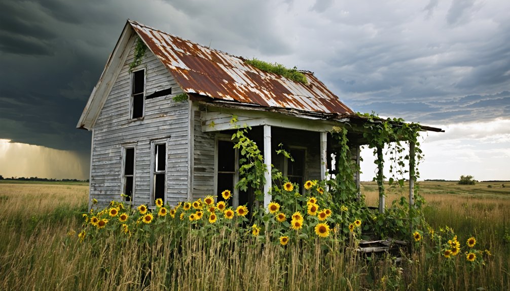
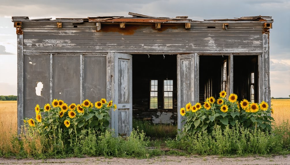
Across Nebraska’s windswept plains, ghost towns face relentless natural forces that methodically erase what human hands built. Weather patterns that once tested homesteaders’ endurance now accelerate structural decay—harsh storms strip wooden buildings bare while alkaline deposits crust abandoned streets.
You’ll find soil erosion dissolving sod structures back into prairie grasslands, particularly visible where Dobytown once stood. Vegetation advances steadily, reclaiming sites like Alkali and Crouse with such thoroughness that human evidence nearly vanishes.
Time compounds these forces: Oreapolis existed merely five years before disappearing entirely, while Montrose’s community buildings eroded until only a lone church remained.
These combined elements—relentless weather, advancing plant life, and decades of neglect—transform once-thriving settlements into landscapes where nature reasserts its primacy over human ambition.
Knox County’s Vanished Settlements: From Blyville to Anawan
You’ll find Knox County’s ghost towns preserved primarily in cemetery records and faded post office registers, where names like Blyville and Anawan exist only as administrative entries marking communities that prairie winds and time have methodically erased.
The natural landscape reclaims these settlements through a steady process—wooden structures collapse under weather’s assault, foundations sink into soil, and vegetation overtakes former townsite boundaries.
What remains are scattered tombstones in isolated burial grounds, some still maintained by descendants who remember when these coordinates represented thriving communities anchored by blacksmith shops and flour mills.
Lost Communities of Knox
- Pischelville’s forced exodus: Santee Sioux threats compelled evacuation after five years, yet Bohemian National Cemetery remains.
- Mars’s brief appearance: Founded 1886, operated modest general store before abandonment.
- Mansfield’s second chance: Abandoned 1871, refiled claims brought sod houses by 1872.
- Blyville’s gradual fade: Slow erosion rather than sudden desertion.
- Anawan’s trace existence: Surviving only in documents and grave markers.
These remnants demonstrate community resilience—people adapting, moving, rebuilding when nature or circumstance demanded freedom to seek better opportunities.
Natural Erasure and Traces
Where Blyville once existed as a speculative townsite one mile west of Old Wyoming, only privately held farmland remains—the earth having absorbed what little development proprietors like James W. Bond initiated.
You’ll find no markers distinguishing these prairies from Anawan’s railroad-adjacent ghost, both erased through plowing and vegetation overgrowth. Natural reclamation operates ruthlessly here: rivers reshape Meadville’s boundaries, tornado shelters vanish beneath soil, and crumbled structures disappear into Knox County’s agricultural expanse.
Yet traces persist—Venus’s fallen church, Spring Ranch’s informational signs, Meadville’s intact store near Niobrara crossings. These remnants fuel community nostalgia while demonstrating nature’s patient sovereignty.
The land you traverse today conceals dozens of 1890s settlements, their unplatted boundaries unmapped, their proprietors’ ambitions dissolved into prairie grass that acknowledges no speculator’s claim.
Belmont and the Rock Tunnel That Led to Nowhere
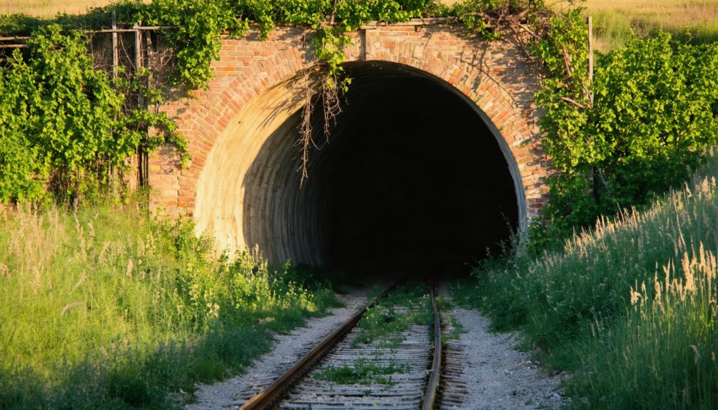
What remains tells you everything about misplaced faith in permanence:
- Children once counted freight car numbers as daily entertainment
- Shops bustled when remote prairie living demanded local services
- The Depression emptied homes faster than hope could refill them
- Automobiles freed residents from railroad dependency
- The tunnel stands defiant near crumbling ruins, Nebraska’s stone monument to obsolescence
You’re standing where ambition met geography and lost.
Finding What’s Left: Maps, Aerial Photos, and Hidden Foundations
Towns fade from maps long before they vanish from the ground. You’ll find Nebraska’s ghost towns through mapping techniques that reveal what bureaucracy erases. Historic railroad maps and early plat books document communities like Blyville and Millerboro, preserving their historical significance when official records don’t.
Ghost towns persist in railroad atlases and surveyor’s plat books long after they disappear from official government maps and memory.
Aerial photographs expose hidden foundations, graded streets, and grain elevators angled oddly against county grids—physical evidence of human ambition reclaimed by prairie grass.
Tools like USGS EarthExplorer and ArcGIS provide satellite imagery showing tree lines marking original streets, roadbeds where trains once ran. You’ll need paper maps in places where GPS fails on remote gravel roads.
County plat books, cemeteries, and oral histories pinpoint locations bureaucrats forgot. These archival sources prove freedom’s geography: communities built beyond government planning, now returning to earth’s indifferent embrace.
Preserved Remnants: Amboy and Rock Bluff as Windows to the Past
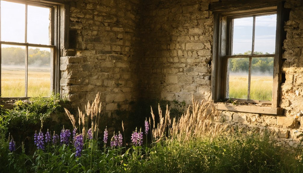
Four miles east of Red Cloud on Highway 136, Amboy’s standing mill and schoolhouse anchor a landscape where archival records meet physical decay. Founded in 1876 as Webster Center, this railroad town’s architectural remnants reveal patterns of settlement and abandonment that define Nebraska’s pioneer legacy.
These structures offer tangible historical significance beyond bureaucratic preservation:
- The mill operated until the 1940s, outlasting the 1890 post office closure by five decades
- Visible depot foundations trace the railroad’s role in relocating the town after fire
- Original schoolhouse walls stand witness to communities that peaked at 100 residents
- Creek-side locations mark both Indian raid histories and natural resource dependencies
- Barn and warehouse remains map economic networks across territorial landscapes
You’ll find these sites resist romanticization—they’re laboratories for understanding how infrastructure shapes human presence and subsequent withdrawal.
Frequently Asked Questions
Can You Legally Visit and Explore Nebraska Ghost Town Sites?
You’ll need legal permissions before exploring most Nebraska ghost towns on private land. Visit regulations vary—pioneer cemeteries grant public access, but abandoned structures require owner consent. Research property rights first, respecting boundaries while pursuing your exploratory freedom.
What Artifacts Are Commonly Found at Abandoned Nebraska Town Locations?
You’ll discover artifacts history through stone tools, pottery sherds, glass beads, and metal implements at these sites. Each relic’s significance reveals trade networks, tribal identities, and evolving human-nature relationships as settlements transformed from indigenous villages to abandoned frontier outposts.
Are There Guided Tours Available for Nebraska’s Most Accessible Ghost Towns?
While urban centers offer guided tour options through haunted sites, Nebraska’s authentic ghost towns lack formal tours. You’ll find historical significance through independent exploration, where nature’s reclamation creates unmediated encounters between you and abandoned homesteads.
A journey through these desolate landscapes provides a glimpse into the past, inviting you to imagine the lives that once thrived in these now-silent communities. Exploring Nebraska’s abandoned ghost towns often reveals relics of a bygone era, from crumbling structures to rusted farm equipment, each telling a unique story. The stark beauty of the surroundings enhances the experience, making it a perfect setting for reflection and adventure.
How Do You Safely Identify Old Wells or Foundations When Exploring?
You’ll master well identification through visual scanning for rusty protrusions and depressions, while foundation safety demands careful magnetic detection and historical record searches. Always respect nature’s reclamation while exploring these liberated landscapes independently.
Which Ghost Town Has the Most Remaining Structures to Photograph?
Like dusty pages in history’s album, Keystone offers you the richest Omaha Ghost Towns photography experience. Multiple Main Street buildings remain—bank, hotel, bar—providing excellent Nebraska Photography Tips subjects. You’ll find authentic frontier architecture reclaimed by prairie elements.
References
- https://negenweb.us/knox/stories/ghosttowns.htm
- https://everafterinthewoods.com/these-deserted-ghost-towns-in-nebraska-are-full-of-history-and-mystery/
- https://history.nebraska.gov/finding-nebraskas-ghost-towns/
- https://kids.kiddle.co/List_of_ghost_towns_in_Nebraska
- https://www.bbcearth.com/news/abandoned-places-reclaimed-by-nature
- https://www.lovemoney.com/gallerylist/86648/americas-empty-ghost-towns-and-why-theyre-abandoned-today
- http://outdoornebraska.gov/wp-content/uploads/2022/08/2022-JULY-RMCS-REPORT-FINAL.pdf
- https://visitnebraska.com/trip-idea/explore-7-authentic-ghost-towns-nebraska
- https://wildlife.onlinelibrary.wiley.com/doi/10.1002/jwmg.22179
- https://www.fhwa.dot.gov/environment/safe_routes_to_school/srts_archive/program_tools/success_stories/nebraska.cfm


