You’ll discover over 600 ghost towns across Nevada where nature systematically reclaims what mining booms abandoned—an 89% settlement failure rate that’s transformed wooden structures, stone foundations, and mining equipment into ecological time capsules. The state’s arid climate preserves architectural remnants while sagebrush pushes through floorboards and native vegetation erases railway beds. From Rhyolite’s concrete bank buildings to completely vanished settlements, these sites demonstrate how economic collapse triggers environmental restoration. The desert’s patient reclamation process reveals patterns spanning more than a century of abandonment.
Key Takeaways
- Nevada has over 600 ghost towns with an 89% failure rate, primarily abandoned after mine depletion allowed native vegetation reclamation.
- The arid climate with under 10 inches annual rainfall preserves wooden structures and slows metal oxidation while facilitating sagebrush restoration.
- Native sagebrush ecosystems are reclaiming former mining lands, with sage-grouse populations now occupying previously degraded areas.
- Boom-bust cycles demonstrate nature’s erasure of human settlements, with architectural decay occurring within decades of abandonment.
- Human occupation halts nature’s reclamation, as seen in Gold Point where permanent residents maintain the site against natural deterioration.
Nevada’s Unmatched Collection of Abandoned Settlements
Nevada harbors more than 600 documented ghost towns—a number that surpasses the state’s current inhabited cities and testifies to the volatile economics of 19th-century mineral extraction.
You’ll find these remnants scattered across every corner of the state, from Virginia City’s northern slopes to the desert expanses near Las Vegas. Combined with California’s abandoned settlements, over 800 sites preserve ghost town culture throughout the region.
This concentration stems from the 1859 silver discovery that earned Nevada its “Silver State” designation, triggering waves of Eastern migrants chasing fortune.
The state’s mining heritage reached its zenith around 1900, when boomtowns like Goldfield housed 30,000 residents before ore depletion and economic collapse transformed prosperity into desertion. Towns like Rhyolite peaked at 5,000 residents with 50 saloons serving prospectors before mining operations ceased entirely by 1910. The Goldfield Hotel, once a thriving establishment in this bustling mining town, now stands abandoned and attracts ghost hunters seeking paranormal encounters.
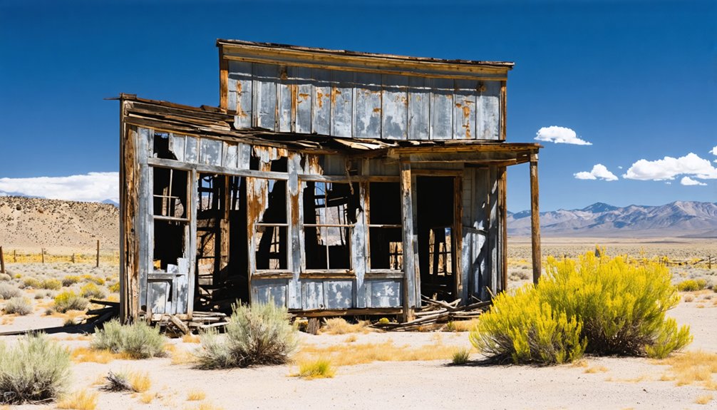
How Desert Climate Preserves Forgotten Mining Towns
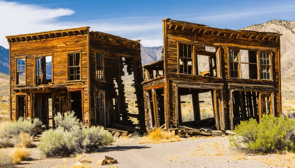
While most abandoned settlements across the American West have crumbled into unrecognizable rubble, Nevada’s ghost towns stand as legible archives of frontier industry, their preservation owing almost entirely to the state’s punishing aridity.
You’ll find dry preservation at work across 600 sites where moisture’s absence halts organic decay and corrosion. Desert conditions create ghostly echoes frozen in time:
- Wooden structures maintain original forms as low humidity prevents fungal rot and structural collapse
- Metal mining equipment oxidizes slowly rather than disintegrating into rust-eaten fragments
- Stone foundations endure intact without rain-induced erosion or freeze-thaw damage
Sparse vegetation and minimal rainfall mean these ruins resist nature’s reclamation. The region receives under 10 inches of rain annually, with some areas averaging as little as 3 inches, creating conditions that effectively mummify historical structures. The desert doesn’t devour history—it mummifies it, offering you unmediated access to authentic frontier remnants standing fundamentally unchanged across decades. At Rhyolite, concrete sidewalks laid in 1907 remain visible alongside the ruins of an opera house and bank building.
Rhyolite: From Boom to Skeletal Remains in a Decade
You’ll find Rhyolite’s trajectory exceptional even among Nevada’s boom-and-bust cycles—rising from desert sand to 10,000 inhabitants in just two years (1905-1907), then collapsing to near-total abandonment by 1916.
The 1906 earthquake and 1907 financial panic devastated the speculative capital fueling Charles Schwab’s mining operations, while subsequent inspections revealed the Montgomery Shoshone Mine had been catastrophically overvalued.
What remains today are concrete skeletons—the three-story bank building, the jail, the train depot—structures whose permanence ironically immortalizes a community that lasted barely longer than their construction. The John Kelly bottle house, constructed from over 50,000 beer bottles in 1906, stands as one of the town’s most peculiar surviving monuments. The Goldwell Open Air Museum, featuring installations like Albert Szukalski’s “The Last Supper,” now draws visitors to this protected ghost town near Death Valley National Park.
Rapid Rise, Faster Fall
When Shorty Harris and E.L. Cross discovered gold in the Bullfrog Hills on August 4, 1904, they sparked one of Nevada’s most dramatic boom-and-bust cycles.
Rhyolite’s fleeting prosperity peaked between 1905 and 1908, transforming from tent city to modern metropolis with remarkable speed. The town blazed with 400 electric streetlights that illuminated its concrete and brick buildings at the height of its brief glory.
You’ll find the town’s trajectory reveals classic frontier contradictions:
- Population explosion: From zero to thousands within 18 months, then crashing to just 14 residents by 1920
- Infrastructure overkill: Three-story banks, electric plants, and stock exchanges built for a future that never materialized
- Economic collapse: The 1907 financial panic exposed overvalued mines, shuttering the Montgomery Shoshone by 1911
Among the ruins, Tom Kelly’s Bottle House stands as a testament to frontier ingenuity, constructed from 30,000-50,000 beer bottles and completed in 1906.
Skeletal Architecture Defies Time
Concrete and stone proved Rhyolite’s unlikely legacy. While wood structures vanished through scavenging after 1914’s final train departure, these architectural remnants endured Amargosa’s harsh winds.
You’ll find skeletal resilience in the John S. Cook Bank’s three-story shell, the Mission Revival depot‘s concrete bones, and Tom Kelly’s 50,000-bottle house—structures that defied complete decay when population crashed from 8,000 to fourteen residents by 1920.
This skeletal defiance separates Rhyolite from typical gold rush ghosts. The depot became Rhyolite Ghost Casino in 1937, the Bottle House transformed into a museum, while concrete shells dominated the skyline decades after banks closed in 1910. The Panic of 1907 triggered the town’s rapid collapse, causing bank runs and investor withdrawals that emptied Rhyolite within years of its peak prosperity. The district produced $1,687,792 between 1907 and 1910, equivalent to over $56 million in 2025 terms, before mines operated at a loss.
Bureau of Land Management preservation and 1984’s Goldwell Open Air Museum now showcase these ruins, proving sometimes what’s left standing tells freedom’s story better than what disappeared.
Death Valley’s Frozen Monument
Two prospectors stumbling across green-hued rocks in 1904 couldn’t have predicted the decade-long spectacle their discovery would release. Frank Harris and Ed Cross triggered Nevada’s wildest boom-to-bust cycle when they staked their Bullfrog claim near Death Valley’s edge.
Within months, 5,000 fortune-seekers transformed barren desert into a metropolis boasting electric plants, stock exchanges, and a $130,000 railroad depot.
The collapse arrived with equal ferocity:
- All three banks failed by 1910
- Population plummeted from 5,000 to 611 residents in five years
- The last train departed in 1914, tracks removed by 1919
These frozen monuments now stand as archival evidence of unchecked speculation.
You’ll find Rhyolite’s skeletal remains managed by the Bureau of Land Management—a cautionary tale of freedom’s double-edged sword preserved in Death Valley’s unforgiving landscape.
Ruby City’s Return to Wilderness in Elko County
Although Utah land promoters envisioned a thriving agricultural settlement when they developed Ruby City in 1912, the ghost town‘s complete erasure from the Nevada landscape tells a different story of frontier ambition meeting environmental reality.
You’ll find barely a dozen faint excavations along what was once the main street, with scattered rock foundations marking where seventy-five homes stood. Nature’s reclamation accelerated after water shortages and poor soil forced abandonment by 1918—just six years after 5,000 acres were purchased.
The hotel, store, schools, and Mormon church that briefly defined this community have vanished entirely. Today, Ruby City exists only in historical records while Elko County’s Ruby Valley ranching culture dominates the landscape.
The road persists, but you’d never know a planned settlement once challenged this wilderness.
St. Thomas: The Ghost Town That Rose From Beneath the Reservoir
Unlike Ruby City’s rapid erasure from Elko County’s landscape, St. Thomas history reveals a more dramatic disappearance. When you explore this ghost town, you’ll discover a community that thrived for seven decades before Lake Mead submersion swallowed it whole in 1938. Founded by Mormon pioneers in 1865, the settlement grew into a prosperous agricultural center with 500 residents before Hoover Dam’s completion sealed its fate.
Nature’s reclamation here differs from typical abandonment:
- Drought conditions since 2012 have exposed foundations and streets once buried under 60-80 feet of water
- Periodic resurfacing in 1945 and 1963 allowed former residents brief reunions
- Walkable ruins now demonstrate how government intervention, not wilderness, claimed this town
You’re witnessing a unique resurrection—a community freed from its watery grave.
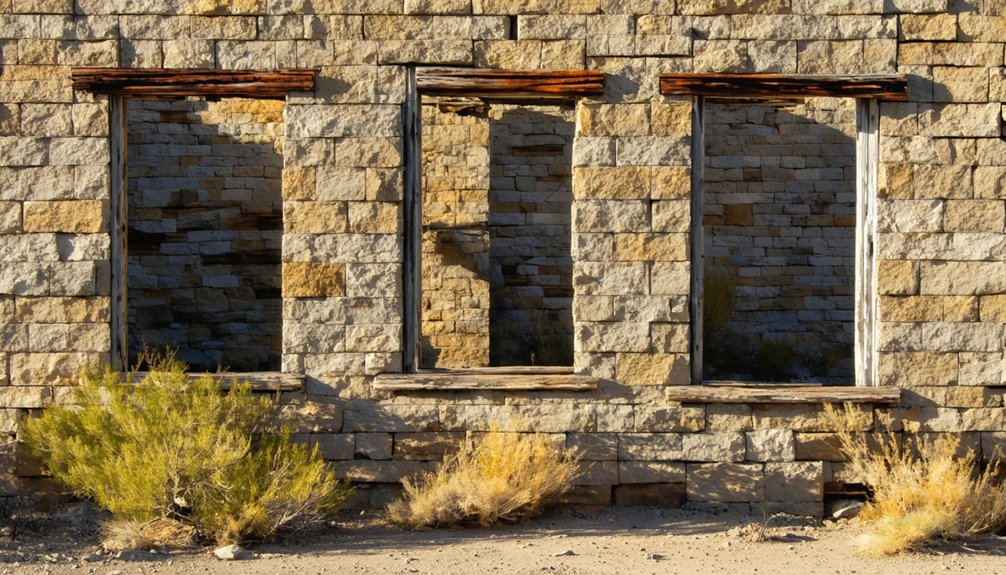
Unionville’s Stone Walls and Samuel Clemens’ Failed Fortune
You’ll find Unionville’s crumbling stone walls and adobe foundations preserved in a creek-fed canyon where Samuel Clemens spent three fruitless weeks in 1862 searching for silver that wasn’t “lying all about the ground, glittering in the sun.”
The settlement’s decline from a thousand-resident county seat to today’s twenty inhabitants left intact physical evidence spanning its 1861-1880 mining lifespan, including three stamp mill foundations and the disputed cabin site marked by state signage.
These architectural remains document both the camp’s $2.7 million mineral production and the harsh reality that separated promotional exaggeration from extractable wealth—a lesson Clemens learned before departing for more lucrative literary pursuits.
Clemens’ Mining Days Failed
When Samuel Clemens arrived in Unionville during the winter of 1861-1862, the surface silver that had sparked the initial rush had already been claimed by earlier prospectors. Clemens’ ambitions crumbled against harsh reality:
- He partnered with Calvin Higbie and Robert Howland for pocket mining, spending three weeks searching for easy surface deposits that no longer existed.
- His quartz mining work proved backbreaking—shoveling tailings in a mill for meager wages while the difficult extraction process yielded insufficient returns.
- A promising 1862 claim slipped away, later proving valuable but never the fortune he’d envisioned.
You’ll find his cabin still standing today, a monument to failed dreams that paradoxically shaped his mining legacy.
Creek-Fed Canyon Preservation
Clemens’ departure left behind more than memories of failure—the canyon itself became a living archive of preservation and loss.
Vista Creek’s 38-acre deeded water rights sustained Unionville’s agricultural ambitions through an 8-inch irrigation system that fed grazing lands.
Today, you’ll find stone foundations and mill ruins documenting 1860s construction techniques, while mature tree canopies reclaim abandoned ranch compounds.
The creek ecology that once promised prosperity now supports natural restoration processes, transforming cultivated fields into wild landscapes.
Ancient Lake Lahontan shorelines remind you that dramatic environmental shifts aren’t new here.
Canyon restoration occurs without human intervention—cheatgrass obscures historical roadbeds while vegetation embraces architectural remnants.
These preserved fragments offer you tangible evidence of boom-to-bust cycles that defined Nevada’s mining frontier.
Surviving Cabins and Foundations
The stone walls rising from Unionville’s canyon floor mark precisely where nineteenth-century ambition collided with geological reality.
You’ll find surviving structures scattered throughout the canyon—foundations of mills that once processed ore, cabins occupied by prospectors who believed exaggerated reports of wealth.
Samuel Clemens’ canvas-roofed cabin stands as evidence to failed fortune-seeking.
Surviving structures reveal Unionville’s historical significance:
- Clemens’ crude cabin remains visible despite disputes claiming he lived in an unmarked dugout
- Old mill foundations demonstrate the town’s peak infrastructure when nearly 1,500 residents occupied 200 houses
- Cemetery markers north of town document both boom-era optimism and Chinese laborers’ forced removal in 1869
These remnants persist among twentieth-century orchards, where fewer than twenty-four residents maintain what prospectors abandoned when $2.7 million in silver couldn’t sustain their dreams.
The Sagebrush Takeover: Nature’s Method of Erasure
As Nevada’s mining economy collapsed across the 19th and 20th centuries, sagebrush ecosystems reclaimed what human ambition had briefly transformed.
You’ll find that 738 of 825 founded towns became ghost settlements—a staggering 89% failure rate driven by resource exhaustion.
Ecological succession worked methodically: depleted mines triggered abandonment at sites like Sutro and Midas, removing human interference and allowing native vegetation to reassert dominance.
While exotic weeds and fire initially degraded these landscapes, they paradoxically facilitated sagebrush restoration over time.
Today, sage-grouse populations reoccupy former mining lands as priority habitats expand across abandoned settlements.
The boom-bust cycle you see documented across 600-1,200 ghost towns represents nature’s patient method of erasure—freedom from human control written in windswept scrub and crumbling foundations.
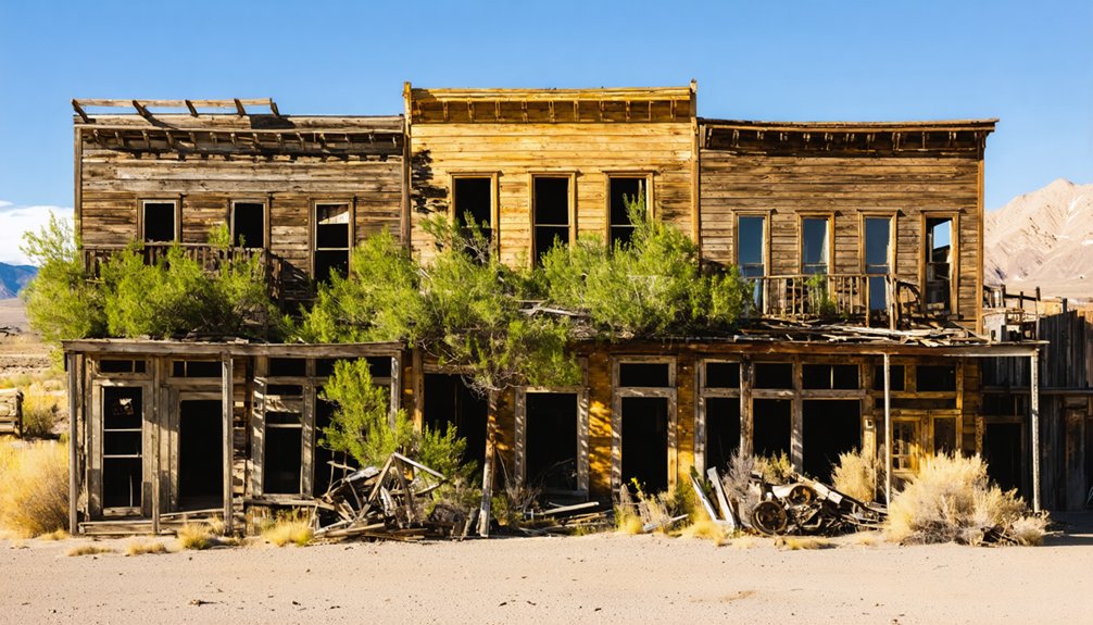
Gold Point: Where Caretakers Live Among the Ruins
Unlike Nevada’s 738 ghost towns left entirely to sagebrush, Gold Point operates through an unusual preservation model: private caretakers who’ve transformed abandonment into occupation.
Seven permanent residents maintain fifty structures where 1,000 once lived during Hornsilver’s 1908 silver boom.
Gold Point’s living preservation includes:
- Former Las Vegas wallpaper hanger Herb Robbins and partners Walt and Chuck Kremin purchasing buildings throughout the late 1970s-1980s
- Original furnishings intact in Senator Harry Wiley’s home, the post office, and general store
- Population swelling from seven to 400 during annual events
This Historical Preservation model defies typical ghost town trajectories.
You’ll find caretakers operating a saloon with a 1909 Brunswick pool table while residing among ruins—proof that human occupation, however minimal, effectively halts nature’s reclamation better than any fence or designation.
Exploring Nevada’s Public Lands for Vanishing History
While Gold Point’s seven caretakers demonstrate preservation through occupation, Nevada’s 600+ ghost towns scattered across 60 million acres of public land tell a different story—one of accelerated decay where abandonment means architectural death within decades.
You’ll find these vanishing landscapes throughout Elko County—Metropolis (1909), Midas (1908), San Jacinto (1870-1938)—and northern Nevada sites like Argenta (1866), Jarbidge (1910), Unionville (1861), and Paradise Valley (1866).
Without human intervention, nature reclaims everything. Rhyolite’s $90,000 bank stands as mere walls; Belmont’s smelter stacks survived only through intermittent reuse.
Goldfield’s Historic Society has fought this erasure since 2005 using state and federal grants for historic preservation. Access these sites through Nevada’s Cowboy Country tours before weather, vandalism, and time erase what mining booms created.
Frequently Asked Questions
Are Nevada’s Ghost Towns Safe to Explore Without a Guide?
You can pursue solo exploration if you’ve taken proper safety precautions: carry water, navigation tools, and emergency supplies. However, historical evidence shows hundreds of thousands of unmarked hazards exist, making preparation absolutely essential for your independence.
What Should I Bring When Visiting Remote Ghost Towns?
Bring essential gear including water, navigation tools, and emergency supplies. Take safety precautions like informing someone of your plans, carrying communication devices, and packing first aid supplies. You’ll need self-sufficiency for true exploration freedom.
Can I Legally Take Artifacts From Abandoned Nevada Settlements?
No, you can’t—even that rusty nail you’re eyeing belongs to Nevada or federal authorities. Artifact preservation laws carry serious legal ramifications: misdemeanors to felonies, plus hefty fines. Your freedom ends where public trust begins.
Which Ghost Towns Are Most Accessible for Families With Children?
Goodsprings and Nelson offer the most family friendly ghost towns you’ll find, featuring kid friendly activities within an hour’s drive. Both provide safe, fenced structures for exploration and don’t restrict your movement through historic spaces.
Do Any Ghost Towns Require Permits or Fees to Visit?
Most Nevada ghost towns don’t charge entry fees, though you’ll encounter visitation rules protecting historical sites. Private locations like Nelson’s Techatticup Mine require tour fees, while public sites like Bodie and Rhyolite remain free with preservation restrictions.
Exploring Nevada’s forgotten mining towns offers a unique glimpse into the harsh yet fascinating lives of those who once sought fortune in the desert. Many of these towns are now ghostly remnants, with crumbling structures and rusted equipment that tell stories of the past. As you wander through these sites, you’ll gain an appreciation for the spirit of adventure that drove so many to these remote locations.
References
- https://everafterinthewoods.com/abandoned-places-in-nevada-that-are-as-creepy-as-they-are-beautiful/
- https://takingthekids.com/abandoned-nevada-places-where-beauty-meets-the-creepy/
- https://www.youtube.com/watch?v=kg18CwWeMnc
- https://nvtami.com/2024/01/15/how-many-ghost-towns-are-in-nevada/
- https://www.bbcearth.com/news/abandoned-places-reclaimed-by-nature
- https://travelnevada.com/ghost-town/
- https://www.conservation.ca.gov/dmr/abandoned_mine_lands/AML_Report/Documents/volume1textonly.pdf
- https://www.visittheusa.com/experience/6-nevada-ghost-towns-explore-if-you-dare
- https://www.atlasobscura.com/things-to-do/nevada/ghost-towns
- https://nvtami.com/nevada-ghost-towns-map/


