North Carolina’s abandoned settlements are vanishing beneath aggressive forest regrowth that transforms ghost towns into ecological monuments. You’ll find Lost Cove’s stone chimneys marking 1860s homesteads within Pisgah National Forest, while Fontana Lake’s 1944 flooding submerged entire communities like Proctor and Judson, displacing over 1,300 families. Moss-covered foundations and rusting equipment reveal how extractive industries—timber, moonshine, mining—created boom-and-bust cycles that left these settlements vulnerable to nature’s reclamation. These remote sites preserve Appalachian history through their gradual return to wilderness, offering insights into the complex relationship between mountain economies and ecological succession.
Key Takeaways
- Lost Cove’s stone chimneys and moss-covered foundations within Pisgah National Forest mark a settlement abandoned in 1958.
- Proctor’s submerged town beneath Fontana Lake and remaining cemetery demonstrate nature reclaiming flooded communities since 1944.
- Forest root systems and moisture actively dismantle structures, with vegetation rendering former settlements increasingly inaccessible.
- Henry River’s weathered cottages abandoned since 1973 show facades overtaken by natural decay and ecological succession.
- Rusting agricultural equipment and mill machinery throughout abandoned settlements tell stories of defunct mountain industries.
Submerged Communities Beneath Fontana Lake
When World War II demanded unprecedented electrical power for the Manhattan Project and Allied munitions production, the Tennessee Valley Authority made a decision that would erase entire communities from the North Carolina landscape.
Fontana Dam’s 1944 completion flooded the Little Tennessee River valley, creating a lake that swallowed over 1,300 families’ homes.
Behind the waters of Fontana Lake lie the homes of 1,300 families, sacrificed for wartime power in 1944.
You’ll find submerged history beneath these waters—towns like Judson with 600 residents, Proctor’s sawmills, and Kirkland Branch’s homesteads now rest under hundreds of feet of water.
This community displacement scattered Swain County residents across three states, with the county losing 25% of its population.
The government’s eminent domain paid some families less than 50 cents per acre, forcing their sacrifice for wartime power needs while transforming vibrant mountain communities into ghost towns.
Among these lost communities, Proctor stood as a bustling logging town founded in 1886, complete with its own post office, school, and theatre before the waters claimed it.
Bushnell, another submerged town, once featured a feed store, grocery store, and train station that served the valley’s residents before the 1940s flooding.
Lost Cove: A Timber and Moonshine Settlement Frozen in Time
While federal power projects remade western North Carolina’s waterways, a different kind of erasure unfolded in the remote Nolichucky Gorge along the Yancey-Mitchell County border.
Lost Cove thrived as a self-sustaining settlement of nearly 100 souls from the 1860s through the early 1900s, its isolation providing perfect cover for a moonshine legacy that began in 1898.
The railroad’s arrival around 1910 brought timber prosperity, but depleted forests and abandoned passenger service sealed the community’s fate.
By 1958, Velmer Bailey’s family—the last residents—departed for economic survival.
The settlement’s story survives through oral history interviews with former residents, capturing memories of church gatherings, community schools, and the rhythms of daily life before abandonment.
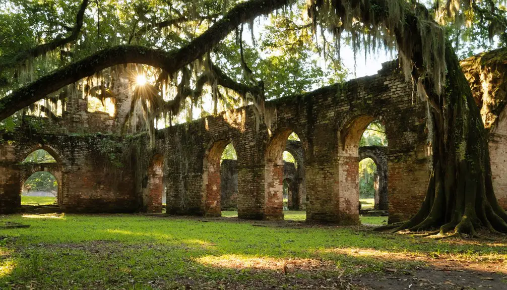
Today, you’ll find stone chimneys and weathered structures slowly surrendering to Pisgah National Forest’s reclaiming embrace, a 95-acre memorial to Appalachian independence now preserved within federal lands.
Four streams originating on the property feed directly into the Nolichucky River, a designated Significant National Heritage Area that draws paddlers and hikers exploring the gorge’s dramatic terrain.
What Remains: Chimneys, Equipment, and Overgrown Foundations
When you venture into North Carolina’s abandoned settlements like Proctor and Mortimer, you’ll find nature systematically reclaiming what humans left behind.
Stone chimneys rise as lonely monuments above the encroaching forest, while rusting farm equipment slowly oxidizes into the soil that once sustained communities.
Moss blankets the old foundations, revealing how quickly forests reassert dominance over cleared land—a process that transforms cultural artifacts into geological features within mere decades.
At Proctor, the Ritter Lumber Mill stands among the scattered remnants of what was once a thriving community along Hazel Creek.
Lost Cove’s crumbling chimneys and old farm equipment tell stories of isolation from a world that existed without electricity until the 1950s.
Stone Chimneys Stand Sentinel
Time erases walls, roofs, and porches, but stone chimneys refuse to surrender.
You’ll find these sentinels throughout North Carolina’s forests—at Lost Cove in Pisgey National Forest, where Civil War-era homesteads left their marks, and along Great Smoky Mountains trails where early 20th-century settlements crumbled.
Their chimney preservation speaks to craftsmen who built beyond their lifetimes. Brunswick Town’s towering brick columns survived British torching during the Revolutionary War, standing defiant above colonial ruins.
Each chimney carries historical significance that transcends mere architecture—they’re tombstones marking where families carved existence from wilderness.
Stone outlasts timber, iron, and human ambition. While nature reclaims foundations and swallows paths, these vertical monuments resist dissolution, offering you tangible connection to generations who valued permanence over convenience. At Elkmont, stone chimneys and foundations line trails where homesteaders, hunters, and loggers once built their lives in the mid-1800s. At Portsmouth Island, 21 buildings still stand including a church and schoolhouse, though the last residents departed in 1971.
Rusting Agricultural Equipment Remains
Metal rusts slower than wood rots, preserving North Carolina’s agricultural past in corroded evidence.
You’ll find these rusting relics scattered across former settlements—from Mortimer’s flood-abandoned mill machinery to Lost Cove’s moss-covered farm tools sprawling across 350 acres.
Nature reclaims slowly: Henry River’s cotton equipment traces persist near foundations where the 1977 mill fire couldn’t erase industrial memory, while Coleridge’s 1880s textile machinery outlines remain despite 1960s closure.
The most dramatic preservation exists where disaster struck quickly.
Diamond City’s 1899 hurricane scattered 500 residents and their equipment across Shackleford Banks, where salt air corrodes agricultural history into the dunes.
Portsmouth’s former mill machinery dots the landscape of what was once a major fishing and shipping town along the Atlantic Coast.
Along the Deep River, 6,000 spindles once hummed at Coleridge’s Enterprise Manufacturing Company before the mill’s 1958 closure left them to decay.
These oxidizing remnants prove humanity’s temporary dominion—machinery that once symbolized progress now surrenders to elemental forces, documenting freedom’s impermanence.
Forest Reclaims Old Foundations
Where human settlement ceases, southern Appalachian forests assert dominance with relentless efficiency.
You’ll find moss-covered foundations at Lost Cove, where 350 acres of crumbling chimneys hide high above the Nolichucky River. Vines creep through Bethel’s abandoned homes while trees burst through pavement cracks, transforming urban decay into compelling wilderness.
At Mortimer, mountain forests swallow brick kiln ruins and sawmill remnants along Wilson Creek. Proctor’s cemetery stands defiant above Fontana Lake’s waterline, accessible only by 12-mile trek or boat.
This forest rejuvenation illustrates nature’s patient reclamation—dense woods conceal what electricity and industry once controlled.
Trails weave through skeletal remains where forests erase human footprints, preserving an eerie calm that reminds you: these mountains ultimately answer to no one.
Reaching North Carolina’s Most Remote Abandoned Settlements
Finding your way to North Carolina’s most isolated ghost towns demands more than curiosity—it requires genuine physical commitment to places where nature has reclaimed what communities once carved from wilderness.
Lost Cove’s 350 acres above the Nolichucky River won’t greet you with parking lots. You’ll push through dense forest and rugged terrain to discover moss-covered foundations where electricity never reached.
Portsmouth Island demands water transit—ferry to Cape Lookout, then your boots through sandy lanes past 21 weathered structures. Proctor’s underwater remains require boat access across Fontana Lake, while the Road to Nowhere terminates six miles short of promises made in the 1940s.
This remote exploration reveals hidden history accessible only to those willing to walk, paddle, and persist beyond modern convenience.
Economic Forces That Created and Destroyed Mountain Communities
The 1820s gold rush in western North Carolina created communities almost overnight, transforming Burke and Rutherford Counties into bustling centers where hundreds of miners traded nuggets and dust as everyday currency.
You’ll find that North Carolina briefly led the nation in gold production before California’s 1849 discovery triggered mass exodus, collapsing entire settlements.
These economic changes reveal how extractive industries—timber, mining, agriculture—dominated the mountain South’s development through the 1950s.
When traditional economies failed, post-1945 leaders pivoted toward tourism, commodifying local culture for outside consumption.
Community resilience depended on adapting to boom-bust cycles, though fierce valley isolation often prevented successful reinvention.
Today’s abandoned settlements stand as monuments to economies built on finite resources, their foundations reclaimed by the forests that once yielded their wealth.
Protecting Appalachian Heritage Through Conservation Efforts

Across western North Carolina’s mountains, conservation organizations have reversed centuries of extractive land use by protecting over 90,000 acres of cultural and ecological heritage since the 1970s.
You’ll find groups like Southern Appalachian Highlands Conservancy and Mainspring Conservation Trust securing Cherokee sacred sites, multi-generational farmlands, and rare ecosystems that industrial interests once threatened.
Through cultural preservation partnerships, these land trusts manage river cane bottomlands for Cherokee artisans while protecting endangered species habitats.
Land trusts weave together Cherokee traditions and ecosystem protection through collaborative management of river cane bottomlands and endangered species habitats.
Heritage conservation extends beyond monuments—you’re witnessing active stewardship of working landscapes where Valle Crucis’s 1,100 acres maintain historic farms alongside natural corridors.
Recent acquisitions demonstrate momentum: a 7,500-acre preserve protects mountain communities’ viewsheds and water sources, while Cowee-West’s Mill Historic District gains National Register status, ensuring your freedom to experience authentic Appalachian landscapes.
The Haunting Beauty of Nature’s Reclamation
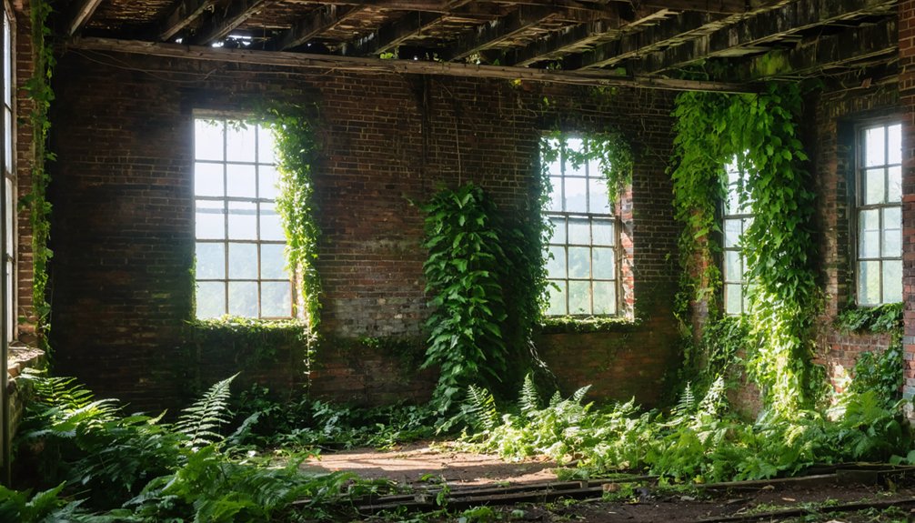
Nature’s patient reclamation of North Carolina’s abandoned settlements creates landscapes where ecological succession transforms human failure into haunting beauty.
You’ll witness how forests don’t merely hide these ghost towns—they actively dismantle them through root systems that crack foundations, moisture that crumbles brick, and canopy cover that erases street patterns within decades.
This vegetative takeover paradoxically preserves these sites by rendering them inaccessible, protecting ruins from vandalism while accelerating their return to wilderness.
Forest Overgrowth and Atmosphere
Where coastal forests once thrived with dense canopies and verdant understories, pale skeletons of bald cypress and loblolly pine now stand as monuments to ecological transformation.
You’ll witness hundreds of leafless snags lining waterways like ashen gravestones, creating ghost landscapes that stretch across North Carolina’s coastal plain.
These haunting expanses aren’t forest regeneration—they’re ecological surrender. Saltwater intrusion kills mature trees while marsh grasses and invasive Phragmites colonize the waterlogged soil beneath dead canopies.
You’re observing the ratchet effect of climate change in real time: sea level rise, intensifying storms, and prolonged droughts combine to accelerate die-back.
Shrubs creep into understories where saltwater seeps inland, signaling the next wave of transformation.
What remains is an eerie reflection of nature’s relentless adaptation when environmental pressures exceed biological tolerance.
Crumbling Structures as Sentinels
The skeletal remains of North Carolina’s abandoned structures function as architectural memorials to cycles of prosperity and collapse that have repeatedly reshaped the state’s social geography.
You’ll find decaying architecture standing defiant against nature’s embrace across forgotten settlements:
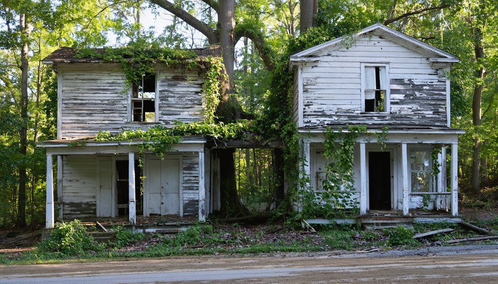
- Henry River’s weathered cottages display grey dying wood and crisscrossed boards across windows, creating haunted facades that survived since 1973.
- Brunswick Town’s stone foundations mark where British forces destroyed a thriving port in 1776, later transformed into Civil War fortifications.
- Lost Cove’s crumbling chimneys pierce through dense Pisgah National Forest canopy, marking 350 acres of moss-covered foundations.
- Coleridge Mill’s turn-of-century buildings preserve Southern textile era layouts amid private surveillance.
These sentinels document human ambition surrendering to wilderness, offering unfiltered glimpses into abandoned chapters of regional history.
Natural Protection Through Inaccessibility
Along North Carolina’s Albemarle-Pamlico Peninsula, rising seas have created natural barriers more effective than any human barrier, transforming 11% of forested land into ghost forests between 1985 and 2019.
You’ll find these haunted landscapes protected not by fences, but by their own inhospitable nature—flooded terrain, standing dead trees, and saltwater intrusion make access nearly impossible.
The Alligator River National Wildlife Refuge exemplifies this ecological evolution, where 32% of land cover changed over 35 years despite official protection.
Remote coastal locations hemmed by farmland increase isolation, while drainage canals create unintended barriers.
You’re witnessing nature’s own exclusion zone, where low-lying, waterlogged conditions deter human intervention.
This inaccessibility enables unchecked shifts to marshes and shrubland, allowing these ghost forests their strange freedom.
Frequently Asked Questions
Are There Any Safety Concerns When Visiting These Ghost Towns?
Yes, you’ll face structural collapses, wildlife encounters, and contaminated groundwater. Urban exploration requires safety precautions: research trespassing laws, avoid unstable buildings, watch for venomous snakes, and respect nature’s powerful reclamation of human spaces.
Can Artifacts or Items Be Legally Removed From These Sites?
No, you can’t legally remove artifacts from these sites. Legal regulations protect archaeological resources on public lands, requiring permits for any disturbance. Artifact preservation depends on maintaining context—removing items destroys irreplaceable historical information and carries criminal penalties.
What Wildlife Might Visitors Encounter in These Abandoned Areas?
You’ll find remarkable wildlife sightings in these areas, from endangered red wolves to alligators. Ecological recovery’s brought bobcats, coyotes, and black rails back. Eastern North Carolina’s refuges host 9%-yearly declining rail populations amid nature’s reclamation.
Are Guided Tours Available for Any of These Ghost Towns?
You won’t find guided exploration at these sites—they’re preserved for self-discovery. You’ll navigate independently, gathering historical insights through remnants and landscapes where nature’s reclamation tells stories conventional tours can’t capture.
How Do Seasonal Weather Conditions Affect Accessibility to These Locations?
Seasonal challenges dramatically restrict your access: winter ice blocks mountain routes, spring mudslides erode trails, summer overgrowth conceals paths, and fall flooding isolates sites. Weather impact transforms these abandoned places into nature’s reclaimed domain year-round.
References
- https://www.islands.com/1977921/proctor-north-carolina-great-smoky-mountains-ghost-town-war-history-fishing-destination/
- https://appalachian.org/lost-cove-ghost-town-in-the-national-forest/
- https://myfamilytravels.com/abandoned-north-carolina-sites-worth-exploring/
- https://www.visitnc.com/list/ncs-mysterious-disappearances-and-abandoned-places
- https://en.wikipedia.org/wiki/List_of_ghost_towns_in_North_Carolina
- https://www.youtube.com/watch?v=iWhjTfCyUpY
- https://www.atlasobscura.com/places/proctor-lost-ghost-town-hazel-creek
- https://wlos.com/news/local/north-carolina-fontana-lake-proctor-town-submerged-underwater-history-100-years-ancestors-families-shorelines-world-war-2-lee-woods-historian
- https://www.thesmokymountaintimes.com/local-news/under-water-stories-towns-lost-fontana-lake
- https://3littlebearsretreat.com/en/4593443/creating-fontana-lake-did-you-know