You’ll find Vermont’s abandoned settlements scattered across forested hillsides, where nature steadily reclaims human ambition. Greenbank’s Hollow lost its woolen mill to fire in 1885, while Glastenbury’s 1898 floods triggered complete disincorporation by 1937. Ricker Basin disappeared beneath Waterbury Dam’s waters in 1938, and West Castleton’s slate quarries fell silent in 1929. Today, cellar holes, crumbling foundations, and overgrown mill sites mark these ghost towns, each telling stories of economic shifts, natural disasters, and wilderness’s patient authority over once-thriving communities now preserved within state parks and hiking trails.
Key Takeaways
- Greenbank’s Hollow, destroyed by fire in 1885, now features only cellar holes and foundations reclaimed by wilderness.
- Glastenbury’s infrastructure was destroyed by 1898 floods, leading to disincorporation in 1937 and complete natural reclamation.
- West Castleton, closed in 1929, is now preserved within Bomoseen State Park where nature reclaims former streets.
- Smith Family Farms on Mt. Horrid transformed from productive hayfields to mature forest after early 1900s abandonment.
- Ricker Basin was drowned by Waterbury Dam construction in 1938, leaving only preserved cemeteries and mill foundations.
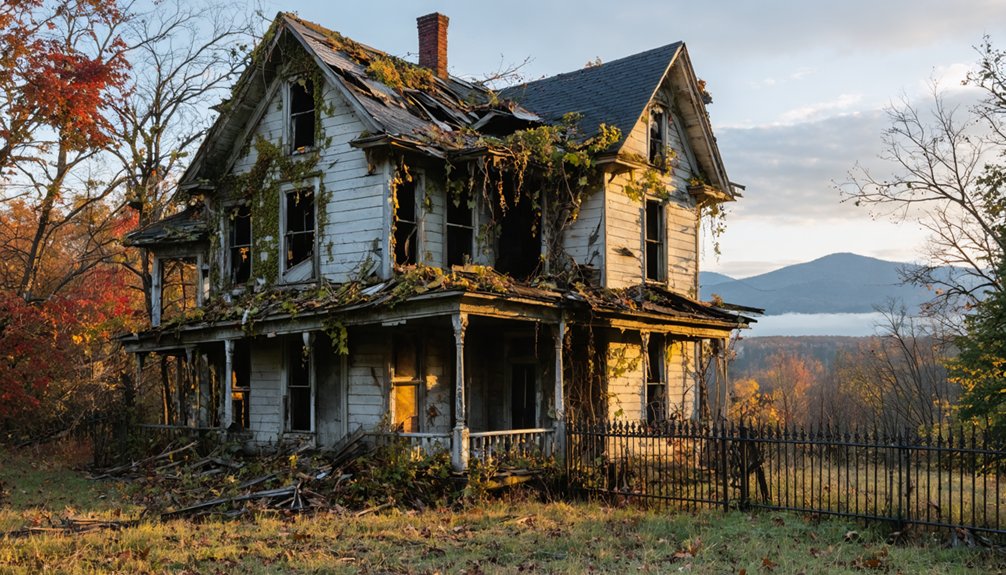
Greenbank’s Hollow: Where Industry Meets Wilderness
When Greenbank arrived in Danville, Vermont in 1849, he transformed a quiet wilderness hollow into the area’s largest industrial enterprise.
The Greenbank history reveals how one entrepreneur created an entire company village centered on his massive five-story woolen mill. You’ll find the mill’s foundation near the stream today, marking where industry once dominated this mountain hollow.
The community thrived until December 14, 1885, when fire consumed everything—the woolen mill, store, post office, homes, and the covered bridge connecting residents to Danville. The blaze started around 10 PM when a lantern accidentally fell, igniting flammable lanolin from sheep’s wool on the factory floor.
Within three years, most inhabitants departed. By 1912, the school closed permanently.
Now you can explore cellar holes and foundations marked by the Danville Historical Society, witnessing how wilderness reclaims what industry once controlled. Joe’s Brook powered 39 enterprises from its source to the Passumpsic River, creating a network of mills that has now vanished. Freedom from civilization returns these ruins to nature.
Glastenbury: Vermont’s Most Haunted Landscape
While Greenbank’s Hollow succumbed to a single catastrophic fire, Glastenbury’s transformation into Vermont’s most infamous ghost town unfolded through decades of economic collapse, natural disaster, and unexplained tragedy.
You’ll find a settlement that peaked at 250 residents in 1880, thriving on logging until 1898 floods destroyed its tourism infrastructure. Vermont disincorporated the town in 1937.
The Glastenbury Mysteries began centuries earlier—the Adnaik tribe avoided hunting here, warning colonists of dark presences and “human eating rocks.”
This Haunted History intensified between 1945-1950 when four people vanished without trace, spawning the “Bennington Triangle” legend. Among the missing was Paula Welden, an 18-year-old college student who was last seen wearing red before she disappeared. The first to disappear was Middie Rivers, an experienced guide who vanished in 1945 and was never found. Author Joseph Citro documented reports of 8-foot creatures, cursed boulders, and dimensional vortexes.
Nature reclaimed what human fear abandoned, leaving only whispers of those who disappeared.
Ricker Basin’s Silent Settlement in Little River State Park
Not all Vermont ghost towns owe their abandonment to mystery and folklore—some fell to forces far more tangible and bureaucratic. Ricker Mills, established in 1816, thrived as a self-sufficient settlement until nature struck decisively.
Some ghost towns didn’t vanish from legend—they drowned beneath reservoirs when bureaucrats chose progress over preservation.
The November 1927 storm sent the Winooski River surging thirteen feet above normal, destroying riverside homes and claiming over fifty lives. The flood aftermath devastated regional infrastructure, prompting federal intervention.
By 1935, authorities broke ground on Waterbury Dam, permanently drowning what remained of Ricker Basin beneath reservoir waters by 1938. The disaster resulted in property losses estimated at half a billion dollars in today’s currency.
You’ll find remnants scattered throughout Little River State Park:
- Cellar holes marking vanished homesteads
- Preserved family cemetery
- Mill foundations
- Schoolhouse ruins
- Forest-hidden church structure
These fragments testify to communities sacrificed for downstream flood control—bureaucracy’s answer to catastrophe. Among the remaining structures stands the dilapidated Almeron Goodell house, a testament to the once-vibrant community.
Somerset: A Windham County Community Lost to Time
Farming decline eventually erased this population.
Census records show two residents in 1990, five by 2000, then near-total abandonment.
You can still locate overgrown cellar holes where families once lived, nature-reclaimed foundations marking boundaries of what existed.
Located in Windham County, Somerset stands as a story of a vanished community.
Like Milton’s transition from thriving agricultural hub to industrial landscape, Somerset experienced its own economic shift that ultimately led to abandonment.
These scattered remnants tell Somerset’s story—a settlement that briefly interrupted wilderness before wilderness reclaimed its territory, leaving only archaeological traces for those seeking Vermont’s disappeared communities.
Lewiston’s Vanishing Traces in Windsor County
Though settlers carved out Lewiston from Windsor County wilderness in 1765, the community’s existence proved temporary. Dr. Joseph Lewis arrived in 1767, establishing what would become a thriving nineteenth-century coal mining center within Norwich township.
Lewiston history demonstrates how economic transformation destroys communities when primary industries collapse.
The settlement’s demise followed predictable patterns:
- Oil replaced coal heating a century ago, eliminating the railroad’s coal deliveries to Dartmouth College
- Windsor Dam construction flooded essential farmland
- Interstate highways bypassed the isolated community
- Economic opportunities vanished completely
- Residents abandoned their homes to encroaching wilderness
Today, you’ll find only stone walls, crumbling foundations, and forest-reclaimed remnants where families once prospered. Hiking trails now wind through the area, offering adventurous visitors access to these historical ruins. The constant flow of history shows that Vermont’s ghost towns emerged, thrived, and ultimately faded back into wilderness.
Nature’s persistent reclamation proves that without economic freedom and adaptability, even established settlements disappear.
Sterling and Smithfield: Forgotten Communities of the North
While Lewiston faded from economic collapse, northern Vermont’s Sterling and Smithfield vanished through legislative decree and geographic isolation.
Governor Isaac Tichenor chartered Sterling in 1805, establishing 23,040 acres that settlers had already begun claiming in the late seventeenth century. Sterling history shows the town survived fifty years before Vermont’s legislature dissolved it in 1856, dividing the land among Morristown, Stowe, Johnson, and Cambridge.
Sterling Township existed for exactly fifty years before Vermont’s legislature erased it from the map in 1856.
When Town Road 43 washed out during the 1950s, Morristown purchased remaining properties rather than maintaining infrastructure, establishing what’s now Morristown Town Forest. You’ll find stone walls marking old boundaries and cellar holes where homesteads stood.
Smithfield remnants prove equally sparse—this northern ghost town left minimal documentation, though it mirrors Sterling’s fate: communities abandoned when geography and economics shifted against human persistence.
West Castleton: Abandoned History Within Bomoseen State Park
The slate industry’s workforce endured conditions that defined industrial exploitation:
- Ten-hour workdays earning less than $2
- Company-controlled housing, food, and transportation
- Dangerous blasting operations and frequent rock collapses
- Manual extraction wasting 85 percent of quarried material
- Irish Catholic immigrants packed into subdivided company dwellings
The 1929 closure transformed West Castleton into Vermont’s most accessible ghost town, now preserved within Bomoseen State Park’s boundaries where nature reclaims former streets.
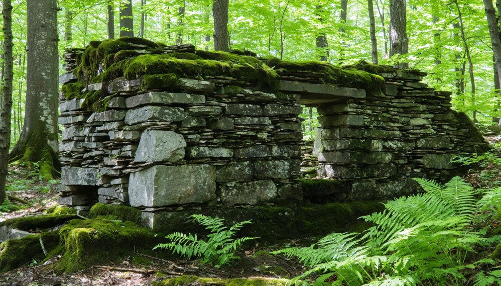
The Smith Family Farms and Agricultural Ruins
High on Mt. Horrid’s east-facing slope at 1900 feet, you’ll find Smith Farm’s vanishing traces within Green Mountain National Forest. Chester M. Smith acquired this 200-acre Rochester property in 1847, transforming wilderness into productive hilly hayfields.
By the early 1900s, abandonment began nature’s slow reclamation.
Today, you’ll discover moss-encrusted foundations where barns and homesteads once stood, evidence of Vermont’s agricultural heritage.
What’s particularly intriguing are the enigmatic dry stone mounds scattered across the property—carefully constructed yet serving no obvious farming purpose. Their origins remain debated, as nineteenth-century farmers left no written record of these structures.
The terrain’s transformation from cultivated farmland to mature forest illustrates nature’s persistent authority over human endeavor, raising questions about what truly endures.
Frequently Asked Questions
Are Vermont’s Ghost Towns Safe to Visit and Explore on Your Own?
You’ll find most Vermont ghost towns reasonably safe for solo exploration if you take proper safety precautions: stay on marked trails, avoid unstable structures, hike during daylight, and tell someone your plans before venturing into remote areas.
As you wander through ghost towns across Vermont’s landscape, you can imagine the stories of those who once called these places home. Each abandoned building holds secrets of the past, while the surrounding nature slowly reclaims what was once vibrant communities. It’s a hauntingly beautiful experience that draws photographers, historians, and adventurers alike to explore these forgotten sites.
What Legal Restrictions Exist for Accessing Abandoned Settlements on State Land?
Like forgotten kingdoms returning to wilderness, you’ll face state regulations protecting wetlands and natural areas on public lands. Property rights don’t extend to abandoned settlements—accessing these sites requires maneuvering through Vermont’s environmental protections and potential trespass laws governing reclaimed territories.
How Can I Find Exact Locations and Directions to These Ghost Towns?
You’ll find exact locations through online maps like Ghost Towns Map at frrandp.com and Geotab.com’s database. GPS navigation coordinates access via Abandonedin360.com’s gold membership, revealing 2,400+ sites where human settlements surrendered to nature’s reclamation.
What Should I Bring When Visiting Remote Ghost Town Sites in Vermont?
You’ll need essential gear like sturdy boots, navigation tools, and water for overgrown trails. Follow safety tips: pack first aid supplies, bear spray, and emergency signaling devices when exploring Vermont’s wilderness-reclaimed settlements where nature’s steadily erasing human traces.
When Is the Best Season to Visit Vermont’s Abandoned Settlements?
Fall offers you ideal conditions—autumn colors frame architectural remnants while dry trails grant unrestricted access to settlements. You’ll discover how seasonal activities like foraging once sustained communities, revealing human-environment interactions before nature reclaimed these spaces.
References
- https://www.onlyinyourstate.com/experiences/vermont/abandoned-places-vt
- https://kids.kiddle.co/List_of_ghost_towns_in_Vermont
- https://obscurevermont.com/tag/ruins/
- https://www.youtube.com/watch?v=YrQNbrIrNT8
- https://en.wikipedia.org/wiki/List_of_ghost_towns_in_Vermont
- https://www.vermonter.com/greenbanks-hollow/
- https://ournewenglandlegends.com/podcast-385-the-ruin-of-greenbanks-hollow/
- https://danvillevthistorical.org/greenbanks-hollow/
- https://www.atlasobscura.com/places/the-forgotten-village-at-greenbanks-hollow-danville-vermont
- https://wend.ca/?p=83940


