You’ll find Arkansas’s most accessible ghost town at Rush in Buffalo National River Park, where interpretive trails wind past zinc mining ruins and abandoned structures from its WWI-era boom. Monte Ne’s submerged resort emerges during droughts near Rogers, while East Calico preserves moonshine-era buildings along Calico Creek. Pinnacle Springs in Faulkner County offers mineral spring remnants, and Bruno’s cemetery marks a vanished farming community. Each site demands proper gear—sturdy boots, navigation tools, and safety equipment—while respecting preservation laws. The stories behind these abandoned settlements reveal Arkansas’s complex industrial and agricultural past.
Key Takeaways
- Rush Ghost Town in Buffalo National River Park features preserved mining structures, residential buildings, and interpretive trails from its zinc mining peak during World War I.
- Monte Ne near Rogers offers partially submerged ruins including hotel foundations, limestone stairs, and a visible tower from its 1901 resort origins.
- East Calico at Calico Rock contains about 20 historic structures, including a jail and cotton gin, from its zinc and timber industry days.
- Pinnacle Springs in Faulkner County shows stone footings from 1880s mineral spring resorts, hotels, and Arkansas Christian College before nature reclaimed it.
- Graysonia and Daleville near Arkadelphia preserve remnants of 1902 timber towns that housed 1,000 residents before declining in 1931.
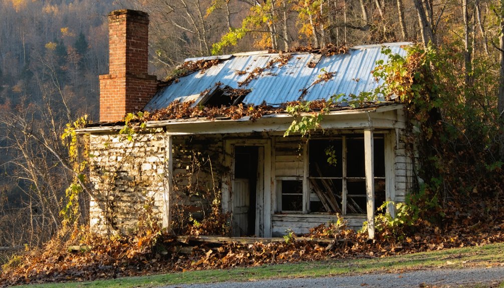
Rush Ghost Town: Arkansas’s Mining Heritage Preserved
Historic preservation efforts by the National Park Service maintain this remarkable time capsule, where you’re free to explore residential structures, mercantile foundations, and mine tailings along interpretive trails.
The Morning Star Loop and Mine Trail lead you past closed entrances where ten companies once extracted precious ore.
Protected within Buffalo National River Park since 1972, Rush offers unmatched access to Arkansas’s mining heritage.
The town’s growth accelerated during World War I when zinc mining operations supported thousands of residents across multiple active mines.
By the 1950s, the post office closed, marking the beginning of the community’s final decline before residents departed in the 1960s.
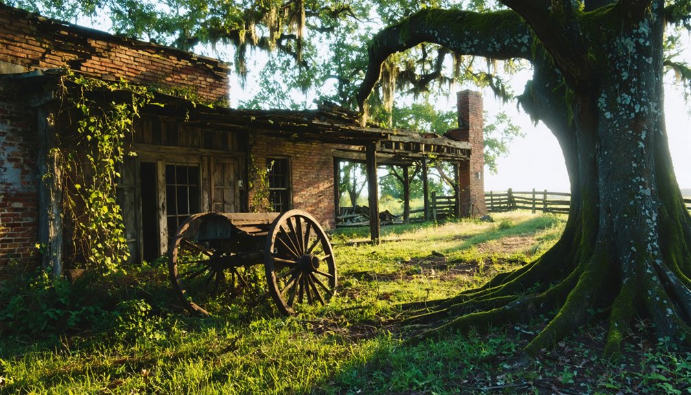
Monte Ne: The Sunken Resort Beneath Beaver Lake
The 1962 Beaver Dam flooded this forgotten paradise, creating opportunities for underwater exploration when conditions permit.
During droughts, you can witness hotel foundations, limestone staircases, and amphitheater ruins emerging from the depths.
The Rogers Historical Museum preserves artifacts from this submerged world, while remaining structures offer glimpses into Harvey’s ambitious vision before nature reclaimed it.
The tower from Oklahoma Row and a four-sided chimney stand as the most prominent visible remnants of the once-grand resort.
William Hope Harvey founded this destination in 1901, purchasing 320 acres at Silver Springs five miles south of Rogers.
Pinnacle Springs: Lost Health Resort of Faulkner County
While Beaver Lake’s waters concealed Monte Ne’s grandeur, another Arkansas health resort vanished into obscurity through abandonment rather than submersion. You’ll find Pinnacle Springs’ remains hidden between Damascus and Guy in Faulkner County, where thirteen mineral springs once attracted nearly 300 residents seeking curative waters. Discovered in 1880, this town flourished with two hotels, twelve bathhouses, and Arkansas Christian College by decade’s end.
The spring water that promised healing ultimately couldn’t sustain prosperity. When ineffective cures and lawlessness tarnished its reputation, the post office closed in 1891.
The town decline accelerated rapidly—residents scattered, buildings burned, and nature reclaimed the land. Carved names and dates along the rock steps serve as memorials of honeymooners and visitors who once flocked to this remote retreat. Ferry services transported visitors across Cadron Creek to reach the resort during high water seasons. Today, only stone footings remain beneath the undergrowth, marking where freedom-seekers once bathed in those legendary pools.
Bruno: Forgotten Farming Community of Marion County
You’ll find Bruno nestled along Hampton Creek in southern Marion County, where sycamores and elms once shaded a thriving farming community of 600 residents.
Today, only a cemetery with 1800s gravestones, a church, and scattered building remnants mark where bustling businesses and a schoolhouse stood until the 1970s.
The weathered cemetery provides a glimpse into the lives of past residents who built their livelihoods in this isolated farming settlement.
This forgotten settlement joins several other vanished towns dotting Marion County’s rural landscape, each reduced to whispers of Arkansas’s agricultural past. Local paranormal researchers have documented Bruno in databases tracking anomalous environmental occurrences reported at abandoned settlements throughout the region.
Marion County Rural Origins
Human activity in Marion County stretches back twelve millennia, evidenced by ancient spear points that mark where prehistoric hunters once stalked game across these Ozark hills.
Native American history flows through successive waves—Archaic, Woodland, and Mississippian peoples who recognized this land’s potential.
The Osage maintained seasonal hunting camps here, understanding what European settlers would later discover: these hills offered sustenance and shelter.
Early settlement patterns followed the waterways, particularly the White River, which became the county’s economic lifeline.
By the nineteenth century, steamboats carried cotton downriver, transforming scattered homesteads into farming communities.
The county’s German families arrived in the 1820s-30s, establishing themselves near the White River and adding their own agricultural traditions to the developing landscape.
You’ll find that Marion County’s rural character wasn’t accidental—it emerged from thousands of years of people reading the land’s possibilities and carving out their independence.
These farming families demonstrated remarkable resilience, weathering droughts, floods, and the Great Depression while maintaining their agricultural heritage across generations.
Vanishing Traces and Remnants
The waterways that once sustained Marion County’s early settlers also nurtured smaller communities that history has nearly erased. Bruno’s remnants tell a haunting story along Hampton Creek’s spring-fed banks.
You’ll find operational church doors still welcoming visitors, while weathered gravestones reveal farmers and shopkeepers who built lives here since the 1800s. The abandoned post office stands amid decay, and forgotten homes await exploration.
After school consolidation in 1974, this once-thriving town of 600 residents gradually surrendered to time’s inevitable pull. The creek bottoms spawned urban legends and folklore stories that locals still whisper about.
You can access this ghost town freely via Highway 65, spending an hour wandering through physical evidence of dreams that flourished then faded across five decades of slow abandonment.
Nearby Ghost Town Cluster
Along Highway 65’s winding route through Marion County, Bruno emerges as the centerpiece of a broader constellation of abandoned settlements that reveal the fragile nature of rural Arkansas communities. You’ll discover Anderson Flat, Zinc, and Eros scattered nearby—each representing different facets of urban decay in America’s rural heartland.
These historical landmarks tell interconnected stories of prosperity and collapse, where mining operations, farming enterprises, and small-town commerce once flourished before economic shifts rendered them obsolete.
Bruno’s church and post office stand alongside similar structures in neighboring ghost towns, creating an explorer’s circuit through forgotten communities.
You’re witnessing the physical manifestation of northern Arkansas’s demographic transformation, where entire networks of settlements vanished within a single generation, leaving only weathered buildings and overgrown foundations.
East Calico: A Ghost Town Within a Living Town
Nestled within the modern boundaries of Calico Rock, East Calico stands as Arkansas’s most peculiar ghost town—a collection of roughly 20 abandoned structures occupying the eastern bank of Calico Creek while daily life continues just blocks away.
You’ll discover a settlement born from moonshine-fueled chaos, where “Peppersauce Alley” once hosted brawlers and vagabonds before railroad prosperity brought respectability in 1902.
The town thrived as a zinc, timber, and cotton hub until economic shifts and floods drove residents westward to higher ground.
Today, you’re free to explore privately-owned ruins designated as tourist attractions in 2007.
Walk through the 1920s jail that once held twenty rowdy Saturday-night prisoners, then wander past the collapsed cotton gin and overgrown railway tracks—tangible reminders of urban preservation‘s ongoing battle against time.
Graysonia and Daleville: Twin Timber Towns of the Railroad Era
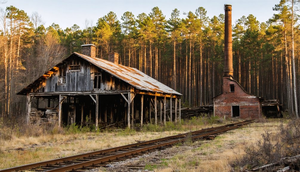
When timber barons exhaust one forest, where do they go? You’ll find the answer in Graysonia and Daleville’s story.
In 1902, Grayson-McLeod Lumber Company established Daleville across from Arkadelphia, but depleted timber forced relocation by 1907. They rebuilt at Antoine River, creating Graysonia—a thriving town of 1,000 souls with free electricity, distilled water, and railroad connections.
For two decades, prosperity reigned until industrial decline struck. The Bemis merger brought brief hope, but timber shortage and Depression economics shuttered operations by 1931.
Mercury smelting offered temporary reprieve in 1932. Today, both towns remain ghost settlements, their town preservation minimal. Yet Graysonia’s railroad operated until 1998, and its locomotives gained Hollywood fame in Spielberg’s “Into the West”—a fitting tribute to communities built on rails and timber.
Planning Your Ghost Town Adventure in Arkansas
Arkansas’s ghost towns beckon modern explorers, but successful expeditions require careful preparation. Target spring or fall when mild weather enhances your journey through historical architecture at sites like Rush within Buffalo National River.
Plan your Arkansas ghost town adventure for spring or fall when comfortable temperatures let you fully appreciate these historic mining settlements.
You’ll need sturdy boots for uneven terrain and off-road capabilities for remote locations like Paraclifta and Chalk Bluff.
Respect boundaries—private property surrounds former attractions like Dogpatch USA, while federal protections govern river sites. Never enter unstable structures or remove artifacts from these preserved remnants. Ghost town legends thrive when we leave traces undisturbed.
Check National Park Service permits before departing, and fuel up in Harrison—services disappear near zinc mining ruins.
Pack water, first aid supplies, and satellite communicators for areas lacking cell coverage. Inform others of your itinerary when chasing Arkansas’s vanished communities.
What to Bring When Exploring Abandoned Sites
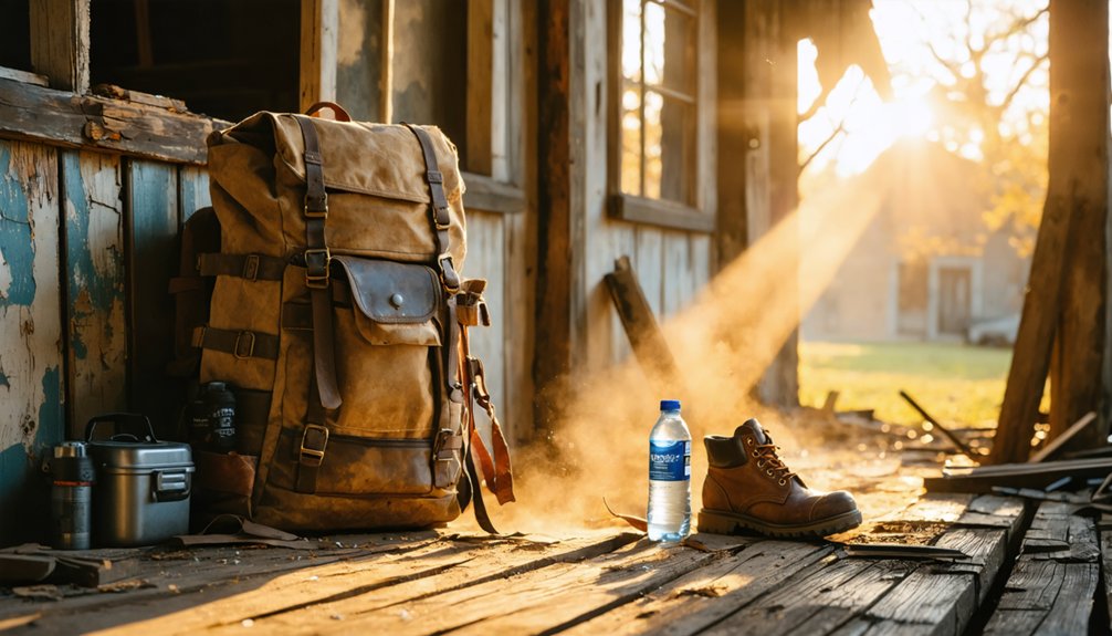
Before venturing into Arkansas’s decaying structures, you’ll need proper protective clothing to shield yourself from the hazards lurking within these forgotten spaces. Sturdy boots, long sleeves, and cut-resistant gloves form your first defense against broken glass and rusted nails.
Your urban exploration gear should include respiratory protection—masks with charcoal filters combat mold and asbestos in crumbling buildings.
Essential equipment includes:
- Lighting systems: Primary flashlight, backup headlamp for night photography, and emergency glow sticks
- Navigation tools: GPS with offline maps, compass, and physical area maps
- Eye protection: Sealed goggles like Pyramex G704T against airborne contaminants
- First aid supplies: Thorough kit with bandages, antiseptic, and pain medication
- Emergency provisions: Water purification tablets, energy bars, and emergency blanket
Pack a multi-tool and whistle for versatile problem-solving and signaling capabilities.
Preserving Arkansas’s Ghost Town History
While exploring these abandoned places captures their haunting beauty, safeguarding what remains requires organized effort and community commitment.
Historical preservation organizations like Preserve Arkansas have championed threatened sites since 1981, identifying endangered locations and mobilizing resources for restoration. You’ll find success stories throughout the state—the Johnny Cash Boyhood Home and Dyess Colony buildings stand restored through dedicated advocacy and funding.
Through dedicated advocacy and strategic funding, preservation organizations have transformed endangered Arkansas landmarks into protected testimonies of our shared heritage.
The Arkansas Historic Preservation Program has distributed nearly $55.5 million across 170 cities, proving that community engagement transforms neglected structures into protected landmarks. When you support these efforts, you’re not just saving buildings; you’re conserving the freedom to access your heritage.
Join local preservation groups, advocate for threatened sites, and help ensure future generations can experience these authentic glimpses into Arkansas’s untamed past.
Frequently Asked Questions
Are Ghost Town Visits in Arkansas Free or Do They Charge Admission?
You’ll find most Arkansas ghost towns are free to explore, including Rush Historic District with its historical preservation efforts. However, paid ghost tours featuring local legends in Eureka Springs and Hot Springs cost $15-$30, letting you choose your adventure.
Which Arkansas Ghost Towns Are Safe to Explore With Young Children?
Despite haunted legends, you’ll find Rush and Calico Rock are your safest bets—marked trails, preserved historical landmarks, and zero actual hazards. Monte Ne and Eros work too with supervision, though crumbling ruins demand watchful eyes on adventurous kids.
Can You Camp Overnight Near Any of These Arkansas Ghost Towns?
You can camp overnight at Rush Ghost Town’s primitive campground with twelve first-come sites. Check camping regulations before arriving, and follow overnight safety tips like securing food properly. Backcountry options exist near abandoned cemeteries for adventurous explorers.
What Time of Year Is Best for Visiting Arkansas Ghost Towns?
Spring and fall offer you the best conditions for exploring Arkansas ghost towns. You’ll enjoy mild temperatures perfect for hiking to historical preservation sites while uncovering local legends, plus stunning wildflowers or foliage enhance your adventure.
As you wander through the abandoned towns in Arkansas, you’ll encounter remnants of a vibrant past, from crumbling facades to rusting machinery. Each site tells a story of resilience and change, providing a backdrop for captivating photographs and exploration. Don’t forget to bring a camera, as the haunting beauty of these ghost towns offers a unique perspective on the state’s history.
Exploring ghost towns in Arkansas history allows visitors to connect with the remnants of bygone eras. As you stroll through the deserted streets, you might stumble upon historical markers that shed light on the lives once lived there. The echoes of the past resonate in the silence, inviting you to discover the rich narratives hidden in these forgotten places.
Do Any Arkansas Ghost Towns Offer Guided Tours or Self-Guided Options?
You’ll find guided ghost tours in Arkansas towns like Eureka Springs and Rogers, where historical preservation meets haunted legends. These walking experiences let you explore at your own pace while uncovering dark tales and mysterious spirits.
References
- https://arkansasfrontier.com/ghost-towns-in-arkansas/303766/
- http://freepages.rootsweb.com/~gtusa/history/usa/ar.htm
- https://www.axios.com/local/nw-arkansas/2024/01/02/arkansas-ghost-towns-mapped
- https://www.youtube.com/playlist?list=PL4jqwLUrhjNQTUht0FCp8mnQYi_DNiUWU
- https://kkyr.com/arkansas-top-5-ghost-towns/
- https://aymag.com/arkansas-backstories-ghost-towns/
- https://www.geotab.com/ghost-towns/
- https://kids.kiddle.co/List_of_ghost_towns_in_Arkansas
- https://abandonedar.com
- https://www.barefoottraveler.com/rush.html