You can explore Louisiana’s most haunting ghost towns by airboat through Manchac Swamp to Frenier, where voodoo priestess Julia Brown‘s grave marks the 1915 hurricane that destroyed everything, or venture into the Atchafalaya Basin’s Sherburne Wildlife Management Area, where 1880s sawmill ruins hide among cypress trees. Ruddock’s stilted lumber town vanished in that same catastrophic storm, leaving only swampland and legends of the Rougarou, while coastal settlements continue disappearing beneath rising waters—and there’s far more to uncover about each cursed, waterlogged site.
Key Takeaways
- Frenier: Located 25 miles west of New Orleans, accessible via airboat tours through Manchac Swamp to visit Julia Brown’s grave and cemetery.
- Ruddock: Former lumber town from the 1890s, now swampland with folklore legends, attracting ghost hunters exploring the abandoned site’s remains.
- Sherburne: 1880s sawmill town remnants within Sherburne Complex Wildlife Management Area, offering public recreation and historical exploration opportunities.
- La Balize: Louisiana’s oldest French settlement at Mississippi River’s mouth, abandoned after hurricanes and coastal erosion, accessible by water.
- Coastal Ghost Towns: Ironton and Plaquemines Parish neighborhoods face submersion, offering glimpses of disappearing communities affected by coastal erosion.
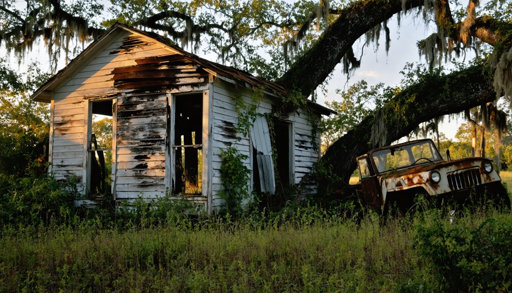
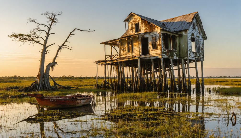
Ruddock: The Hurricane-Ravaged Cypress Lumber Town
Deep in Louisiana’s treacherous swamplands, where cypress trees rise from black water and alligators outnumber people, the ghost town of Ruddock once thrived as a bustling lumber community of 900 souls. Built entirely on stilts in the 1890s, this remote boomtown connected families through wooden sidewalks stretching across murky waters.
Residents lived without electricity or roads, handing grocery lists to passing train engineers bound for New Orleans. The Ruddock Cypress Company established the sawmill town as a company enterprise, drawing workers to this isolated wilderness. By 1915, the settlement had grown to include a telegraph office, post office, train engine shop, and boarding house.
Then September 1915 brought devastation. A Category 4 hurricane with 145 mph winds and 15-foot storm tides obliterated everything. Desperate survivors clung to cypress trees as their town vanished beneath the flood. Between 28-58 perished in Ruddock alone.
Today, only swampland remains, steeped in cypress folklore and hurricane legends. Ghost hunters explore these waters seeking spirits, while the Rougarou’s shadow lingers among ruins.
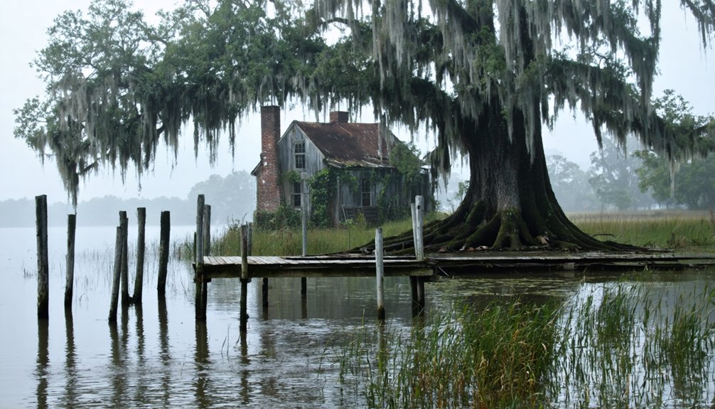
Bayou Chene: The Floating Community of the Atchafalaya Basin
Where else could an entire town drift upon the waters, its residents steering between floating homes by pirogue as casually as others walk city sidewalks? Bayou Chene thrived in the Atchafalaya Basin from the 1830s, where 500 souls built lives on the water’s edge. You’d have found swampers, moss pickers, and traditional fishing families creating a self-reliant paradise 40 miles north of Morgan City.
Community resilience defined these basin dwellers—they constructed homes, raised cattle, and operated schools and churches despite complete isolation. The settlement’s legitimacy was confirmed when a U.S. post office opened in 1858, cementing Bayou Chene’s status as an official community. The 1927 flood marked the beginning of their end, though spillway construction in the 1930s delivered the final blow. Levees around the Basin Floodway System increased flooding in the area, forcing inhabitants to abandon their waterborne homes.
Today, twelve feet of silt buries their legacy, yet descendants guard the memory of this remarkable floating settlement fiercely.
La Balize: Louisiana’s Oldest French Settlement at the River’s Mouth
You’ll find Louisiana’s oldest French settlement vanished beneath the Mississippi River’s muddy waters, though La Balize once stood as the colony’s first line of defense when established in 1699.
The wooden fort and its 62-foot seamark tower controlled all river passage to New Orleans, housing pilots and fishermen in homes built on stilts above the delta marshes.
Despite surviving rebuilds after the devastating hurricanes of 1740 and 1778, La Balize met its final destruction in the September 1860 storm, leaving nothing but historical records of this waterlogged outpost.
Robert de La Salle claimed this strategic river mouth for France in 1682, positioning it above the delta’s major forks where the Mississippi split into multiple passages toward the Gulf.
The settlement was rebuilt in 1853 on the Southwest Pass, following yet another cycle of hurricane destruction that had obliterated its previous location on San Carlos island.
First French Fort Established
In 1699, French colonists hammered together a simple wooden fort at the Mississippi River’s mouth, establishing La Balize—meaning “seamark”—as Louisiana’s first European settlement. You’ll find this strategic outpost was positioned near Plaquemines Parish, where Robert de La Salle had planted France’s claim seventeen years earlier.
The French architecture evolved quickly—by 1721, engineers erected a 62-foot wooden pyramid rising above the delta’s marshes, guiding ships through treacherous passages.
Colonial history records King Louis XIV appointing Nicolas Godefroy Barbin as chief administrator in 1703, while fishermen and river pilots made this watery frontier their home. They’d wave lanterns and fire rockets from watchtowers, controlling access to the Mississippi‘s crucial forks where fortunes were made steering vessels toward New Orleans. By 1767, builders constructed a pyramid-shaped wooden lighthouse after previous structures had been destroyed by the harsh delta environment. The settlement’s population peak reached around 800 residents, with families establishing a children’s school that operated into the 20th century.
Hurricane Destruction and Rebuilds
Nature’s fury tested La Balize relentlessly throughout its existence, transforming this strategic settlement into a heartbreaking cycle of destruction and defiant rebuilding.
Pre hurricane settlements vanished repeatedly—the 1740 gale completely washed away the original village, birthing the Isle of San Carlos from churning waters. Your ancestors rebuilt defiantly, only to watch the 1778 storm demolish their 40-yard wooden pyramid lighthouse.
The relentless 1860 season delivered three devastating blows: August floods submerged everything under ten feet of water, September’s hurricane obliterated the village entirely, and October’s storm ravaged inland areas.
Coastal erosion patterns finally claimed victory—survivors relocated five miles upriver to Pilottown. Yet even this refuge fell to Hurricane Katrina in 2005, proving the Mississippi Delta’s swampy vulnerability unconquerable.
Frenier: Home of the Voodoo Priestess Curse Legend
Twenty-five miles west of New Orleans, you’ll find the skeletal remains of Frenier, where Aunt Julia Brown‘s eerie prophecy—”One day I’m going to die and take the whole town with me”—became horrifying reality on September 29, 1915.
As mourners gathered at her funeral, a Category 4 hurricane roared ashore with 145 mph winds and a 13-foot storm surge, obliterating the town and killing nearly 60 residents in a single night. The storm destroyed neighboring towns including Ruddock and Napton.
Today, you can visit the isolated Frenier Cemetery via airboat tours through Manchac Swamp, where Julia’s solitary grave still sits 100 yards from the mass burial site of her neighbors. The cemetery is a mass grave with no official records of who lies buried there.
Julia Brown’s Prophetic Song
Could a folk healer’s eerie song have foretold one of Louisiana’s deadliest natural disasters? In her final weeks, Julia Brown rocked on her porch, guitar in hand, singing haunting self-composed hymns. Her repeated refrain chilled listeners: “One day I’m gonna die and take all of you with me.”
The woman who’d once traveled from New Orleans to Ruddock dispensing folk remedies and spiritual practices now felt exploited by ungrateful townsfolk. Her prophecy echoed through Frenier as she strummed and sang, weeks bleeding into months.
When she died on September 29, 1915, the entire town gathered for her funeral—whether from respect or fear remains unclear. That same day, a catastrophic hurricane swept through, seemingly fulfilling her darkest prediction.
The 1915 Hurricane Connection
As mourners lowered Julia Brown’s casket into the soggy earth that September afternoon, dark clouds gathered overhead with unnatural speed. Within hours, a Category 4 hurricane slammed into Grand Isle with 145 mph winds, fulfilling what locals whispered was Brown’s voodoo curse.
The storm’s timing seemed impossibly precise—her prophetic song about rising waters became horrifyingly real as 13-foot surges swallowed Frenier whole.
The hurricane killed 275-300 people across Louisiana, with nearly 60 deaths in Frenier and Ruddock alone.
Twenty-five died when the railroad depot collapsed. Every building flattened. Miles of tracks vanished beneath raging waters.
Today, mythology legends and folklore preservation keep Brown’s story alive. The mass grave holding 29 victims remains accessible in Manchac Swamp’s depths—a haunting affirmation of nature’s fury and one woman’s alleged final revenge.
Exploring Frenier’s Abandoned Remains
Deep in the Manchac Swamp, where cypress knees pierce black water and Spanish moss drapes like funeral shrouds, Frenier’s cemetery stands as the town’s sole surviving remnant.
You’ll find Julia Brown’s grave positioned 100 yards from the mass burial site containing dozens of hurricane victims—an isolation that’s fueled local folklore for generations.
Today’s cemetery draws paranormal investigators and curious travelers seeking spiritual legends attached to the voodoo priestess.
A staged crucifix marks what many believe is Julia’s resting place, though the swamp has reclaimed most evidence of the once-thriving community.
You can reach this haunting location via airboat tours that weave through the bayou, where guides recount curse warnings and ghost sightings reported among the decaying cypress stumps.
Sherburne: From Thriving Sawmill to Wildlife Refuge
Located three miles south of Krotz Springs along LA 975, Sherburne emerged in the 1880s as a bustling sawmill town that fed on the Atchafalaya Basin’s seemingly endless cypress and hardwood forests.
You’ll discover how the timber industry transformed this wilderness into a thriving community before exhausting its resources by the 1930s.
Today, you’re free to explore what remains:
- 11,780 acres managed by Louisiana Department of Wildlife and Fisheries
- Ghost town remnants within the Sherburne Complex Wildlife Management Area headquarters
- 47.7 km² of recovered habitat showcasing nature’s resilience
- Public access for hunting, fishing, and wildlife observation
This abandoned sawmill settlement now champions wildlife conservation, proving that destruction doesn’t have to be permanent.
You’ll witness firsthand how forests reclaim their territory.
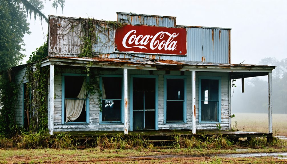
Louisiana’s Disappearing Coastal Communities: Modern Ghost Towns in the Making
You’ll find ground zero in Plaquemines Parish, where historically Black communities like Ironton and St. Rosalie Plantation confront an uncertain future. These former plantation sites face flooding that no levee can permanently stop.
Terrebonne and Lafourche Parishes risk complete submersion within decades. Unlike traditional ghost towns that fade slowly into history, these coastal settlements disappear beneath waves—whole neighborhoods becoming Louisiana’s newest underwater monuments to nature’s relentless advance.
These towns once thrived with vibrant culture and community, hosting annual festivals in Louisiana ghost towns that celebrated their rich heritage. As the waters continue to rise, the echoes of laughter and music will fade, leaving behind only memories of joyful gatherings. Preserving these stories becomes essential, ensuring that future generations will remember the spirit of the people who once called these places home.
Frequently Asked Questions
Are There Guided Tours Available for Louisiana’s Ghost Towns?
You’ll find guided tours at historic plantations and New Orleans’ French Quarter rather than abandoned ghost towns. These experiences blend history preservation with eco-tourism, offering you authentic storytelling through moss-draped cemeteries and antebellum estates where legends still linger.
For those intrigued by the past, there are also opportunities to explore historic ghost towns in Louisiana, where remnants of vibrant communities tell tales of a bygone era. These sites offer a different perspective on the state’s rich history, filled with stories of resilience and transformation. Each visit can transport you to a time when these towns were bustling havens, now eerily quiet yet full of character.
What Safety Precautions Should Visitors Take When Exploring Abandoned Sites?
Ironically, chasing freedom through abandoned places requires strict discipline. You’ll need hazard awareness for unstable structures and flooded areas, plus security tips like exploring with groups, wearing protective gear, and keeping emergency contacts ready before venturing into Louisiana’s forgotten landscapes.
Can You Legally Explore Ghost Town Properties or Is Permission Required?
You’ll need permission before exploring ghost town properties, regardless of urban legends suggesting otherwise. Property ownership determines access rights—always verify ownership through public records and obtain written consent to explore legally and avoid trespassing charges.
In addition to obtaining permission, it’s important to be aware of the specific laws governing abandoned properties in Louisiana, as they may differ from other states. Local regulations might outline how to approach these sites safely and legally, ensuring a respectful exploration. Always research the history of these locations as they may hold significant cultural or historical value.
When venturing into forgotten places in Louisiana, it’s crucial to take into account the local customs and traditions that may have surrounded these areas. Engaging with the community can provide valuable insights and promote a greater appreciation for their historical significance. Respecting the memories tied to these locations ensures that exploration remains meaningful and responsible.
What Is the Best Time of Year to Visit Louisiana Ghost Towns?
Perfect timing—visit Louisiana ghost towns during fall (October-November) when cooler weather meets Halloween’s supernatural vibe. You’ll experience historical legends come alive through preservation efforts, comfortable temperatures for exploration, and fewer crowds restricting your adventure through these haunting landscapes.
Exploring abandoned towns in Louisiana offers a unique glimpse into the past, where stories of lost communities linger in the air. Each location tells its own tale through decaying structures and faded memories, inviting you to wander through their haunting beauty. As you navigate these forgotten streets, you’ll uncover the rich cultural history and resilience of the people who once thrived there.
Are There Any Artifacts or Structures Still Visible at These Locations?
You’ll find rotted building remnants at Ruddock, a working cemetery at Taft, and submerged platforms at Bayou Chene. Historical preservation efforts are minimal, but local legends like Julia Brown’s voodoo curse add mystique to visible ruins.
References
- https://www.ezhomesearch.com/blog/ghost-towns-in-louisiana/
- https://en.wikipedia.org/wiki/List_of_ghost_towns_in_Louisiana
- https://thebayouinsider.substack.com/p/ghost-towns-and-forgotten-roads-louisianas
- https://classicrock1051.com/17-ghost-towns-louisiana/
- https://www.ghosttowns.com/states/la/la.html
- https://jonesswanson.com/mails/louisianas-disappearing-towns-tool-kit/
- https://hnoc.org/publishing/first-draft/julia-brown-curse-hoodoo-hurricanes-and-storm-swamped-ruddock
- https://lobservateur.com/2015/09/30/ruddock-washed-away-100-years-ago/
- https://www.youtube.com/shorts/tbfJ5o6dd1E
- https://manchacgreenway.org/ruddock/