You’ll discover Maryland’s haunting ghost towns from Chesapeake Bay’s eroding shores to western mountains. Explore Blooming Rose, the state’s oldest abandoned settlement from 1791, or witness Holland Island’s last Victorian house that collapsed into the bay in 2010. Walk through Port Tobacco Village’s colonial-era courthouse, Fort Ritchie’s empty Cold War barracks, and the decaying C&O Canal community of Four Locks destroyed by the 1924 flood. Each crumbling foundation and weathered structure tells stories of Revolutionary War veterans, watermen communities, and forgotten industries waiting below.
Key Takeaways
- Holland Island: Former waterman village with 360 residents in 1910; last Victorian house collapsed in 2010 due to severe erosion.
- Port Tobacco Village: Maryland’s second-largest colonial seaport with 500 residents; now features 1819 courthouse and colonial-era architecture remnants.
- Fort Ritchie: Cold War and WWII training site in Blue Ridge Mountains; features empty barracks, graffiti, and 1930s structures.
- Point Lookout Light: Built 1830, served as Civil War site and lighthouse; accessible to explorers with shipwreck and wartime history.
- Four Locks: 950-acre Chesapeake & Ohio Canal community destroyed by 1924 flood; includes ruins of Charles Mill from 1790.
Blooming Rose: Maryland’s Oldest Abandoned Settlement
Perched on a windswept tableland forty-four miles west of Cumberland, Blooming Rose stands as Maryland’s oldest abandoned settlement. Its empty fields whisper tales of the hardy pioneers who first carved homesteads from this frontier in 1791.
Silent stone foundations and forgotten paths mark where determined settlers once built their dreams upon Maryland’s unforgiving western plateau.
You’ll find this ghost town in Garrett County, where Revolutionary War veterans like Richard Hall claimed their bounty lots and established the region’s first abandoned agriculture community.
The pioneer settlement thrived briefly on this elevated plateau overlooking the Youghiogheny River, where cool temperatures and fertile soil once supported wheat production.
John Rutan and Catherine Jones arrived in 1787 as the area’s second permanent settlers, yet despite promising beginnings, the settlement eventually succumbed to abandonment.
Today, historical markers commemorate these freedom-seeking frontiersmen who briefly tamed Maryland’s western wilderness.
Holland Island: The Village That Sank Into the Chesapeake Bay
If you’d traveled to Holland Island in 1910, you would’ve found a thriving waterman’s village of 360 souls—complete with whitewashed homes, a general store, and the laughter of children spilling from a two-room schoolhouse.
But the Chesapeake Bay had other plans for this five-mile stretch of clay and silt. By 1922, the island’s last families fled as relentless tides devoured their world, and today only a lonely sandbar marks where an entire community once prospered.
The island’s 41 skipjacks, along with 10 schooners and 36 bugeyes, once formed an impressive fleet that worked the bay’s rich oyster beds and fishing grounds. Holland Island is just one of over 400 islands in Maryland and Virginia that have sunk beneath the Chesapeake’s waves over the past three centuries.
Island’s Historic Fishing Community
When Captain John Smith first explored these waters in 1608, he couldn’t have imagined the vibrant fishing village that would emerge on this remote speck of land in the Chesapeake Bay.
By 1910, you’d find 350 souls living their maritime heritage through daily rhythms of casting nets and dredging oysters. The island’s rugged watermen commanded over 90 fishing vessels, transforming their isolated home into the bay’s most populated outpost.
You’d witness a self-sufficient community thriving on the water’s bounty—crabbing, oyster harvesting, and shipbuilding fueled their economy.
Their community resilience shone through nearly 70 homes, bustling stores, a schoolhouse, and even a baseball team. A community center and doctor’s office served the islanders’ social and medical needs, completing the infrastructure of this remote settlement.
These weren’t just survivors; they were pioneers who built prosperity from Chesapeake’s depths, crafting boats and futures from sheer determination. Yet by 1914, significant shoreline erosion began devouring the island’s west side, marking the beginning of an unstoppable decline.
Erosion and Final Collapse
The same Chesapeake waters that fed Holland Island’s thriving community would ultimately consume it. You’ll find a cautionary tale in these vanished shores—coastal erosion claimed half the island’s 160 acres during the twentieth century alone.
Land subsidence from groundwater withdrawals accelerated the disappearance as the clay-and-silt foundation literally sank beneath rising tides. Stephen White, a waterman and Methodist minister, waged a 15-year campaign spending approximately $150,000 on wooden breakwaters, sandbags, and rocks to resist the erosion. The last Victorian house standing finally collapsed into the Chesapeake in October 2010, marking the end of Holland Island’s physical legacy.
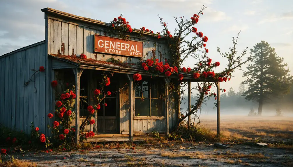
Port Tobacco Village: From Boom to Ghost Town
You’ll find Port Tobacco Village’s story among Maryland’s most dramatic reversals of fortune—once the colony’s second-largest seaport with ships carrying tobacco to distant shores. Now, it is home to just 13 residents wandering streets where 500 once lived.
The colonial trading hub that bustled with merchants bartering Caribbean sugar and Chinese silks became a victim of silted waterways and railroad routes that passed it by.
What remains is a haunting proof to how quickly prosperity can vanish when rivers fill with sediment and steel rails choose a different path.
The 1819 courthouse still stands as a reconstructed monument to the town’s former prominence, now housing exhibits on tobacco culture and the archaeological findings that tell Port Tobacco’s story. Visitors can explore the one-room schoolhouse that operated for 77 years, offering a glimpse into traditional rural education practices.
Historic Colonial Trading Hub
Long before American independence, Port Tobacco Village commanded the colonial commerce of Maryland’s tidewater region as a bustling international seaport. You’ll discover this 1634 settlement evolved from native trade with Algonquian-speaking peoples into Maryland’s second-largest port by the 1700s.
Ocean-going vessels navigated the Port Tobacco River directly to wharves where merchants shipped hogsheads of tobacco to European markets and received Scottish goods in return.
The colonial architecture at Stagg Hall, built around 1766, reveals how Scottish traders like Robert Fergusson conducted their mercantile empire.
Revolutionary patriots including John Hanson and Thomas Stone walked these streets, conducting business that fueled colonial resistance.
The Port Tobacco Courthouse stands as a testament to its status as Charles County’s first seat of government—a position it held for two centuries before silting rivers ended its maritime dominance.
Dramatic Population Decline
During its 19th-century peak, Port Tobacco Village bustled with nearly 300 residents who traded tobacco and timber through Maryland’s second-largest port. You’ll discover how poor farming practices sealed this county seat’s fate—clearcutting and tobacco cultivation stripped topsoil, sending erosion cascading into the Port Tobacco River.
By 1783, the once-navigable channel had transformed into marsh, strangling the port’s lifeblood.
The death blow came when railroads bypassed the town in 1895, pulling the county seat to La Plata. Today, you’ll find just 21 residents wandering streets that once welcomed European schooners.
Economic revitalization remains elusive despite its 1989 National Register designation, as preservation challenges persist in this haunting reminder of colonial ambition swallowed by nature’s revenge.
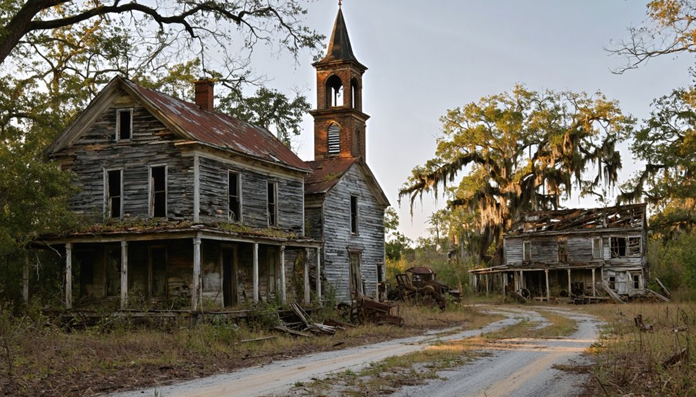
Daniels: The Decaying Mill Town Straddling Two Counties
Straddling the Patapsco River between Baltimore and Howard counties, Daniels stands as one of Maryland’s most hauntingly atmospheric ghost towns. You’ll discover crumbling stone foundations, rotting cars, and graffiti-covered ruins scattered among weeds and vines—stark reminders of industrial decay that consumed this once-thriving textile mill community.
The ghost towns of western Maryland offer a captivating glimpse into the past, revealing forgotten stories and the remnants of lives that were once full of activity. As you wander through these deserted landscapes, the echoes of laughter and industrious workers seem to linger in the air, creating a surreal atmosphere. Each visit to these towns invites exploration and reflection on the state’s rich but tumultuous history.
The C.R. Daniels Company’s 1968 decision to evacuate 90 families proved lifesaving when Hurricane Agnes devastated the area in 1972, destroying remaining structures. Today, you can explore riverfront remnants along the three-mile Alberton Road trail through Patapsco Valley State Park.
You’ll encounter Saint Stanislaus Kostka’s graveyard with weathered stones, the old dam, and a historic train bridge. Listed on the National Register since 1979, Daniels offers unrestricted access to Maryland’s abandoned industrial past.
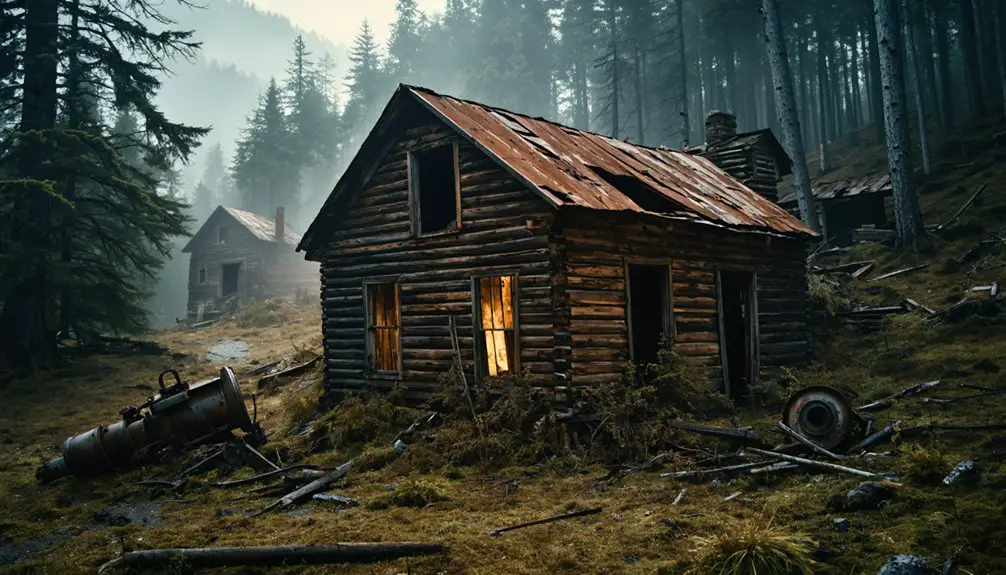
Fort Ritchie: Military Ghost Town of Western Maryland
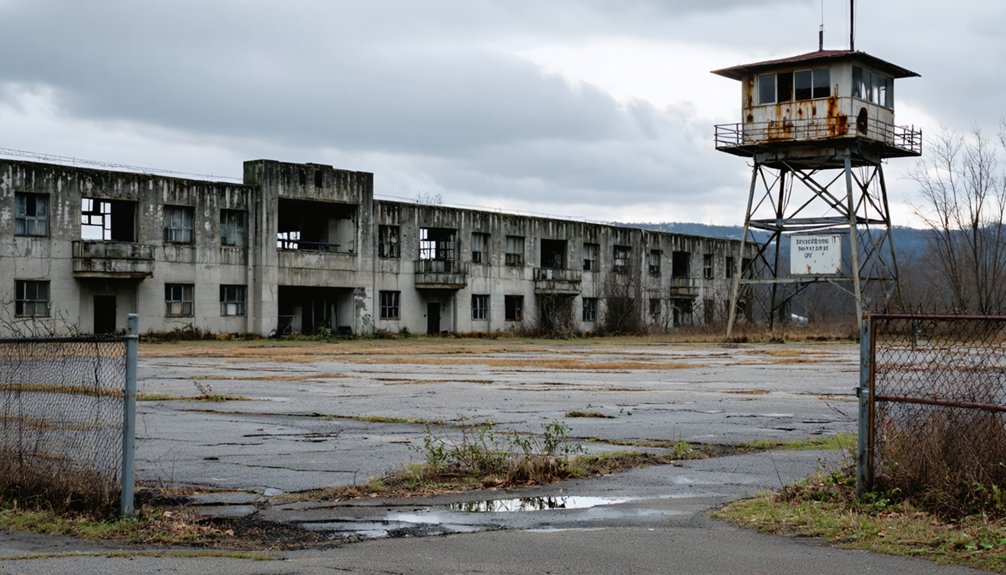
Tucked into the Blue Ridge Mountains of Western Maryland, Fort Ritchie stands as a haunting reminder of Cold War secrecy and WWII intelligence operations that once trained thousands of soldiers within its now-crumbling stone walls.
You’ll find rows of empty barracks and graffiti-marked classrooms where the legendary Ritchie Boys—many Jewish refugees from Nazi Germany—once practiced interrogation techniques in mock European villages before helping win the war.
Though the Army shuttered this sprawling base in 1998, its robust early-1900s stone buildings still pierce the landscape, slowly transforming from military ghost town into a revitalized community hub.
Base Closure and History
Long before soldiers marched across its grounds, Fort Ritchie’s story began with an ice company’s ambitions in 1889. The Buena Vista Ice Company chose this 1,400-foot elevation site for America’s southernmost ice-producing operation, creating a manmade lake that thrived until the early 20th century.
The military history transformed dramatically when Maryland’s National Guard claimed it in 1926. By WWII, you’ll find this became the legendary training ground for 19,600 intelligence troops, including the famed Ritchie Boys—many Jewish refugees who’d return to Europe hunting Nazis.
The 1995 Base Realignment and Closure Commission sealed its fate. Fort Ritchie officially closed in 1998, leaving behind robust stone structures from the 1930s. Site preservation efforts finally emerged in 2021, protecting these weathered monuments to American intelligence warfare.
Visiting the Abandoned Site
Unlike most military ghost towns frozen in decay, Fort Ritchie has emerged from abandonment into a second life. You’ll discover a unique blend of urban exploration and preservation challenges across this 638-acre site.
Wander through elegant stone buildings from the early 1900s, their robust construction defying decades of neglect. Empty barracks and reconstructed European village remnants await your investigation, though you’ll notice broken windows and graffiti marking years of illicit occupation.
The Ritchie History Museum, housed in a 1932 officers’ mess hall, anchors your visit with authentic exhibits. You’re free to explore streets where few pedestrians roam, discovering both abandoned 1930s structures and revitalized spaces.
This mountain site beneath Pennsylvania’s border offers unrestricted access—where classified intelligence training once occurred, you now walk freely through history.
St. Mary’s City: Colonial Capital Turned Historic Site
For 61 years, St. Mary’s City thrived as Maryland’s capital, where colonial governance flourished in the Assembly Hall and religious freedom took root.
You’ll discover how this center of commerce declined after 1695 when the capital relocated to Annapolis.
Today, Native American history and colonial stories emerge through over 300 archaeological sites, making this living history museum a symbol of liberty’s early struggles in British North America.
Forest Haven Asylum: Abandoned Institution With a Dark Past
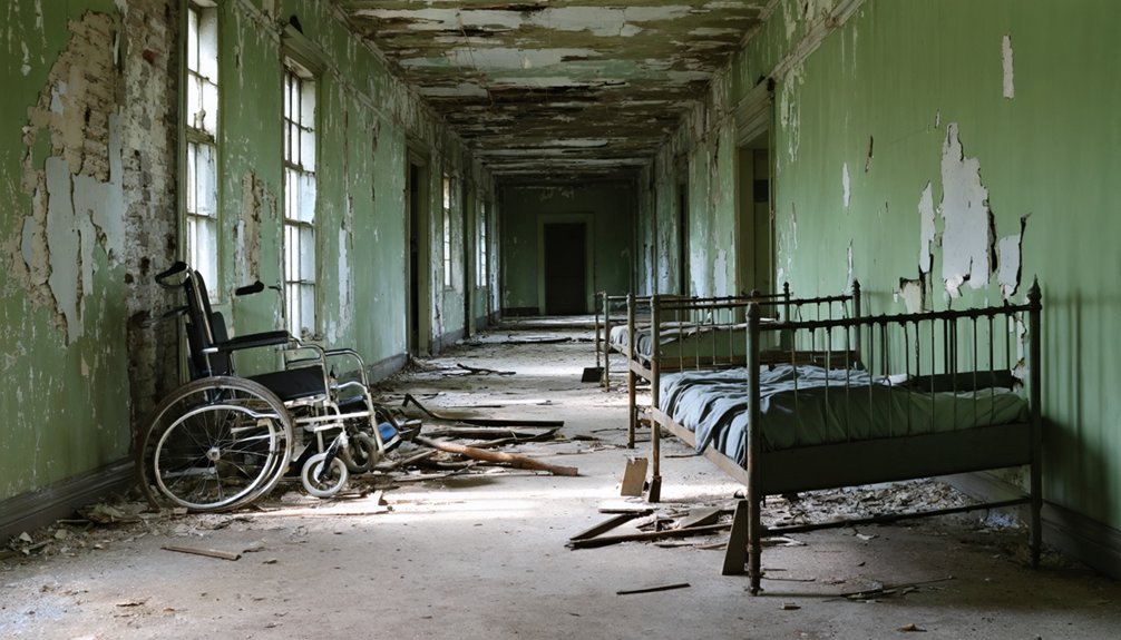
Hidden histories emerge from unmarked graves where hundreds lie buried in shallow plots, some exposed by erosion.
The 1976 federal lawsuit exposed constitutional violations that led to its 1991 closure.
Today, you’ll find nature reclaiming this dark chapter of institutional America.
Glenn Dale Hospital: Haunting Tuberculosis Sanatorium
Fifteen miles northeast of Washington, D.C., the skeletal remains of Glenn Dale Hospital stand frozen in time across 200 acres of overgrown Maryland countryside.
You’ll find 23 Colonial Revival buildings—complete with rooftop gardens, open-air breezeways, and flooded underground tunnels—where tuberculosis patients once sought healing through fresh air and sunlight from 1934 onward.
Though you can’t legally enter (police patrol constantly), you’ll spot the decaying structures from Glenn Dale Road.
The architectural preservation efforts earned National Register status in 2011, recognizing its historical significance as D.C.’s tuberculosis battleground.
Asbestos contamination forced closure in 1982, leaving behind morgues, isolation wards, and whispered ghost stories.
While redevelopment debates simmer, this haunting sanatorium remains Maryland’s most compelling abandoned medical campus.
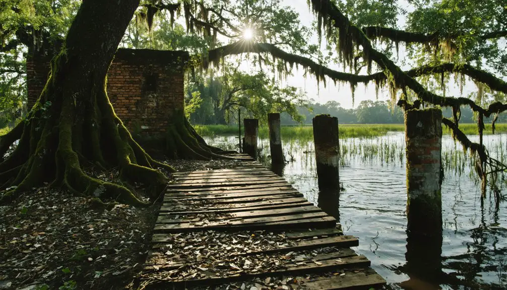
Four Locks: Ghost Town Along the C&O Canal
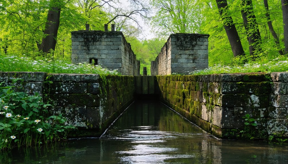
Where Prather’s Neck bends into the Potomac River, you’ll discover Four Locks—a ghost town that rose and fell with America’s canal era. This 950-acre landscape showcases remarkable industrial archaeology, from hand-hewn lockhouses to limestone cliffs plunging 80 feet into riverine ecosystems below.
What You’ll Find:
- Original stone structures including the mule barn, Jacques’ warehouse, and Lockhouse 49 with its historic fireplaces
- Four massive locks that raised boats 32 feet through 8.25-foot steps between 1836-1839
- Charles Mill ruins dating to 1790, predating the canal’s arrival
- Walking paths along Four Locks Road, built in 1844 to connect neighboring towns
The 1924 flood silenced this once-thriving community of stores, repair facilities, and worker housing. It left behind authentic remnants of canal-boat commerce.
Point Lookout Light: Haunted Lighthouse and Shipwreck Site
At Maryland’s southernmost tip, where the Potomac River surrenders to the Chesapeake Bay, Point Lookout Light stands as a weathered sentinel with stories darker than most maritime beacons dare tell. Built in 1830 for $3,350, this lighthouse nocturnal witnessed transformation from peaceful navigation aid to Civil War nightmare when Camp Hoffman imprisoned 20,000 Confederates nearby—3,000 never left.
You’ll find the structure expanded in 1883 to two full stories, its fog signal tower relocated in 1889 after repair buildings muffled the warning bells. First keeper James Davis died within months of lighting the beacon in September 1830, leaving daughter Ann to tend it for seventeen years.
Though deactivated in 1966, the lighthouse remains accessible, inviting you to explore where maritime duty met wartime horror.
Frequently Asked Questions
Is It Legal to Explore Abandoned Buildings in Maryland Ghost Towns?
No, you’ll face trespassing laws if you explore without permission. Even ghost town structures remain private property requiring owner consent. Trespassing carries fines up to $500 and 90 days jail, crushing your freedom-seeking adventures.
What’s the Best Time of Year to Visit Maryland Ghost Towns?
When autumn leaves surrender their grip, you’ll find Maryland’s ghost towns at their haunting best. Late fall through early winter offers ideal seasonal weather, minimal visitor crowds, and bare branches revealing hidden ruins you’re free to explore independently.
In addition to exploring ghost towns, history enthusiasts will appreciate the diverse collection of historic sites in Maryland. From colonial landmarks to Civil War battlegrounds, each site tells a unique story that deepens your understanding of the region’s past. As you wander through these remnants of history, you’ll sense the echoes of those who walked before you.
Exploring openair relics in Maryland adds an exciting dimension to your historical adventure. As you delve into abandoned structures and forgotten landscapes, you’ll uncover stories of resilience and change that shaped the state’s identity. This hands-on experience brings history to life, allowing you to connect with the past in a way that text and images cannot convey.
Are There Guided Tours Available for Maryland’s Abandoned Settlements?
You’ll find guided tours throughout Maryland’s historic settlements, where experienced guides blend historical preservation with urban exploration techniques. They’ll lead you through candlelit streets and cemeteries, sharing authentic ghost stories while respecting these atmospheric locations’ cultural significance.
By visiting historic sites in Maryland, you can immerse yourself in the region’s rich past, uncovering the stories of the people who shaped its history. Each location offers a unique glimpse into the state’s culture, from colonial settlements to revolutionary landmarks. Engaging with these sites not only educates but also inspires a deeper appreciation for Maryland’s heritage.
As you explore historic sites in Maryland’s countryside, you’ll encounter stunning landscapes that complement the rich narratives of the past. Many of these areas are preserved to showcase the natural beauty that has remained unchanged for centuries. Whether hiking along scenic trails or visiting quaint farms, each experience enriches your understanding of the state’s historical journey.
Which Maryland Ghost Towns Are Most Family-Friendly for Children?
The proof’s in the pudding—Daniels Ghost Town offers family-friendly activities along scenic trails where kids explore historical preservation through crumbling ruins and abandoned cars, while Station 7’s Terror Trail provides age-appropriate scares for adventure-seeking families.
Do I Need Special Permits to Photograph Abandoned Sites in Maryland?
You’ll need photography permits for commercial shoots on Maryland state park lands, but private photography doesn’t require permits. Legal restrictions prohibit drone use without permission. Always respect property boundaries and avoid disturbing historical sites during your explorations.
References
- https://en.wikipedia.org/wiki/List_of_ghost_towns_in_Maryland
- https://kids.kiddle.co/List_of_ghost_towns_in_Maryland
- https://www.marylandhauntedhouses.com/real-haunts/
- https://www.youtube.com/watch?v=Obb_sDHYm9A
- https://www.atlasobscura.com/things-to-do/maryland/abandoned
- https://www.geotab.com/ghost-towns/
- https://www.mdmountainside.com/blog/post/haunted-history-places-to-visit-for-a-ghostly-good-time/
- http://www.abramscreek.com/galleries/rail-hike-kitzmiller/index.html
- https://loyolanotredamelib.org/php/report05/articles/pdfs/Report6Hennighausenpg11-26.pdf
- https://archive.org/stream/tablelandtrails22unse/tablelandtrails22unse_djvu.txt