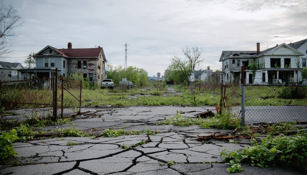
You’ll find New York’s most accessible ghost towns at Doodletown near Bear Mountain, where crumbling stone foundations disappear into the forest, and Tahawus in the Adirondacks, featuring a towering 1854 blast furnace and weathered miners’ cottages you can explore on foot. North Brother Island sits tantalizingly close to Manhattan but requires special permits—only four issued yearly. Love Canal in Niagara Falls remains fenced off as a toxic reminder of environmental disaster. The guide below reveals the best seasons to visit, essential safety gear, and photography tips for capturing these haunting landscapes.
Key Takeaways
- Doodletown in Hudson Highlands features crumbling foundations, weathered staircases, and historic cemeteries accessible since its 1965 abandonment.
- Tahawus offers weathered miners’ cottages, an 1854 blast furnace, and accessible roads deep within Adirondack wilderness for exploration.
- North Brother Island contains overgrown hospital ruins but requires rare permits; only four issued annually with seasonal restrictions.
- Late September to October provides optimal conditions with autumn foliage, cooler weather, and atmospheric decay for ghost town visits.
- Pottersville and New Ireland showcase historic churches, moss-covered foundations, and trail access for additional accessible exploration options.
Doodletown: A Rockland County Relic Near Bear Mountain
Tucked into the Hudson Highlands just north of Bear Mountain, Doodletown sits frozen in time—a ghost town where crumbling stone foundations rise through carpets of barberry and tangled vines. You’ll discover weathered staircases leading nowhere and paved roads winding through forest where 300 residents once thrived.
The Palisades Interstate Park Commission emptied this hamlet by 1965 through eminent domain, promising ski slopes that never materialized.
Local legends whisper about the town’s peculiar name—possibly from Dutch “Dead Valley”—while historical preservation efforts maintain informational signs marking vanished homes and businesses. Hike the Doodletown Trail to explore two cemeteries where June family descendants rest, their gravestones testament to five generations. The hamlet’s origins trace back to 1762 when the Tomkins family led development efforts in what was once Lenape territory. Stephanus VanCortlandt purchased the land from the Haverstraw Indians in the 1680s, establishing European ownership centuries before the town’s settlement.
Revolutionary War history permeates these woods; British troops marched through here attacking Fort Clinton in 1777.
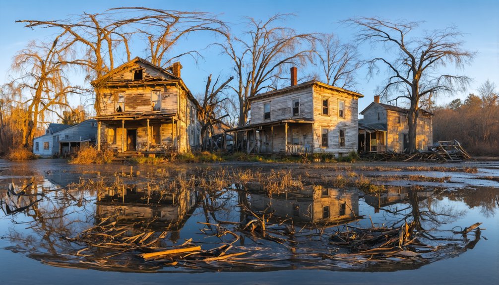
Tahawus: The Adirondacks’ Best-Preserved Abandoned Settlement
Deep in the Adirondack wilderness, Tahawus stands as New York’s most intact ghost town—a place where you can walk past weathered miners’ cottages, peer into the massive 1854 blast furnace with birch trees sprouting through its stonework, and trace the footsteps of Theodore Roosevelt on the night he learned he’d become president.
This industrial archaeology site tells two abandonment stories: first in 1858 when titanium dioxide impurities stumped early ironworkers, then again in 1989 after WWII-era mining operations ceased. The Mitchell Stone Company now operates here, extracting construction aggregate from tailings with deposits estimated to last another twenty years.
You’ll find ten 1940s buildings plus McNaughton Cottage, where Roosevelt received news of McKinley’s assassination in 1901. The village once thrived with 16 dwellings, along with a school, church, and even housed the first organized state bank in the Adirondacks. The Open Space Institute’s preservation efforts now protect this 212-acre core, accessible via asphalt road through Adirondack Park.
Unlike fenced-off ruins elsewhere, you’re free to explore this authentic ghost town independently.
North Brother Island: NYC’s Forbidden Wildlife Sanctuary
You’ll find North Brother Island just 300 feet offshore in the East River, yet it remains one of New York’s most inaccessible ghost towns—a 20-acre wilderness of crumbling hospital wards where Typhoid Mary spent decades in forced quarantine.
As you explore more about the haunting remnants of urban life, numerous ghost towns across New York state tell stories of their own. Each location offers a glimpse into the past, filled with abandoned buildings and forgotten histories that evoke a sense of eerie beauty. From dilapidated facilities to overgrown streets, these sites capture the imagination of those willing to venture off the beaten path.
historic sites in New York reveal not just the stories of their former inhabitants, but also the evolution of the city itself. As you wander through these remnants, you can almost hear the echoes of the past, whispering tales of triumph and tragedy. Each site offers a unique opportunity to reflect on the cultural and historical significance that shaped the landscape we know today.
The ruins now vanish beneath thick vegetation as black-crowned night herons nest in collapsed tuberculosis pavilions and smallpox treatment facilities. The southern tip still features remnants of the first lighthouse, an octagonal federal structure with a mansard roof built in 1868.
Since the city designated it a bird sanctuary in 2001, you’re legally forbidden from stepping foot on the island without special permits that are almost never granted. The island’s tragic history includes the 1904 General Slocum disaster, when the burning ship collided with its shores, claiming over 1,000 lives in one of New York City’s deadliest maritime catastrophes.
Island’s Dark Medical History
The crumbling brick wards of North Brother Island conceal one of New York’s most haunting medical legacies—a century-long chronicle of quarantine, death, and isolation that began when the city purchased the 13-acre island in 1885.
You’ll find where Riverside Hospital treated typhoid, tuberculosis, and scarlet fever until 1943, enforcing separation from society that often meant permanent exile.
The island’s quarantine history reached its ethical breaking point with Mary Mallon, imprisoned here for 23 years despite appearing healthy. This asymptomatic typhoid carrier cooked for eight families, sparking outbreaks, yet her confinement until death in 1938 ignited fierce debates about medical ethics versus public safety—individual liberty sacrificed for collective protection. She contaminated at least 122 people during her career as a cook before her final confinement.
The 1904 General Slocum disaster transformed these shores into an emergency morgue, claiming 1,021 lives and marking New York’s deadliest tragedy before 9/11. The island’s location near Hell Gate, a treacherous whirlpool notorious for wrecking ships, contributed to the accumulation of maritime debris along its shores.
Nature Reclaims Abandoned Buildings
Since humans abandoned North Brother Island over five decades ago, native vegetation has transformed its crumbling hospital wards into a forbidden jungle—one of New York City’s most improbable wildlife sanctuaries. You’ll find twenty-five original buildings in extreme dilapidation, their walls breached by sumac, dogwood, and American holly that NYC Parks deliberately planted to accelerate ecological recovery.
This urban decay serves purpose—the island’s seclusion attracts nesting herons, egrets, and cormorants seeking refuge from the city’s chaos. The island sits less than a mile from Manhattan in the East River, positioned between the Bronx and Riker’s Island. Though you can’t legally visit this Forever Wild preserve, its transformation proves nature’s resilience.
What was once a quarantine hospital now shelters federally protected species, offering them freedom within dense urban landscape where wildlife habitat remains precious and rare. The site gained infamy as home to Typhoid Mary, who was confined here until her death in 1938 after contaminating at least 122 people.
Access Restrictions and Permits
While most New York ghost towns welcome curious visitors, North Brother Island stands completely off-limits—a 13-acre refuge where crumbling tuberculosis pavilions and collapsing corridors remain locked behind layers of legal protection.
The NYC Parks Department enforces strict access restrictions to protect nesting shorebirds and prevent injuries from deteriorating structures.
If you’re determined to explore, the permitting process demands compelling academic or scientific justification. Consider these requirements:
- Seasonal blackout: March 21-September 21 remains completely forbidden during breeding season
- Limited approval: Maximum four permits granted annually
- Mandatory escort: Parks staff accompanies every permitted visit
- Private transport: You’ll charter your own boat across East River currents
Even researchers face rejection.
Freedom-seekers must accept that some places choose wildlife over human wanderlust.
Love Canal: Niagara Falls’ Environmental Disaster Site
You’ll find the fenced-off remains of Love Canal in southeastern Niagara Falls, where 21,000 tons of buried chemical waste transformed a working-class neighborhood into America’s most infamous toxic ghost town.
Between 1942 and 1953, Hooker Chemical dumped pesticides, PCBs, and dioxin into an abandoned canal, which later seeped into 800 homes and schools—causing burns on children’s skin, blackened vegetation, and a swimming pool literally lifted by the chemical sea beneath it.
The 1978 federal emergency declaration here sparked the Superfund program, leaving behind a stark landscape of razed buildings and warning signs that stands as a permanent reminder of environmental negligence.
Chemical Waste Burial History
The abandoned waterway that would become America’s most infamous toxic waste site started as an ambitious dream in 1892, when William T. Love envisioned connecting the Niagara River’s upper and lower sections.
By the 1940s, Hooker Chemical Corporation transformed this failed canal into a dumping ground for industrial pollution that would haunt generations.
Between 1942 and 1953, you’ll find evidence of staggering chemical contamination:
- 22,000 tons of toxic waste buried in corroding metal drums
- Twelve known carcinogens including dioxin and PCBs
- Chlorobenzenes and pesticides seeping through clay barriers
- Halogenated organics percolating into surrounding soil
Hooker capped the site in 1953, selling it for $1 with liability warnings that authorities ignored, building homes and schools directly atop this chemical graveyard.
National Environmental Impact Legacy
When Niagara Falls Gazette reporters David Pollak and David Russell tested sump pumps near Love Canal in October 1976, their findings cracked open America’s first major environmental health crisis.
You’re standing where 21,000 tons of toxic chemicals—PCBs, dioxin, pesticides—transformed an entire neighborhood into a cautionary tale. The government’s response reshaped environmental law forever. That $4 million EPA approval? It launched the Superfund program, fundamentally changing how America handles hazardous waste.
This toxic legacy isn’t just history—it’s active environmental remediation. The clay-capped canal, razed buildings, and fenced perimeter remind you that freedom includes the right to clean air and safe homes.
Over 1,300 families fought back, securing $20 million in settlements. Their battle established your right to know what’s buried beneath your feet.
Current Abandoned Landscape State
Behind chain-link fencing and warning signs, Love Canal’s 16-acre toxic heart sits entombed beneath a clay cap—a silent monument to 21,000 tons of chemical waste that once bubbled through basement floors and lifted swimming pools from the ground.
Today’s landscape reveals industrial pollution’s lasting grip:
- Vacant lots where 800 homes once stood, now integrated into restricted perimeters
- Corroded waste drums still occasionally surfacing through contaminated soil
- Boarded structures surrounding the core zone, including the deteriorating 99th Street School
- Blackened trees marking chemical seepage zones beyond the fenced boundary
You can’t enter this ghost neighborhood, but land reclamation efforts continue.
The EPA’s ongoing monitoring detects cancer-causing compounds in air samples, proving some disasters don’t fade—they’re merely contained.
Pottersville: Warren County’s Flood-Ravaged Village
Nestled along U.S. Route 9 within Adirondack Park, Pottersville tells a story of community resilience rather than flood devastation. While a 1918 fire consumed downtown buildings, this Warren County hamlet endured through adaptation.
You’ll discover the 1847 Methodist Church—the county’s oldest still holding services—standing as a testament to historical preservation.
The Natural Stone Bridge and Caves showcase eastern America’s largest marble cave entrance, drawing explorers to what locals once knew as a thriving agricultural center producing over 50,000 pounds of butter annually.
Summer camps and boarding houses replaced the Wells House hotel, transforming this stage coach stop into a tourist destination.
With just 424 residents today, Pottersville persists not as ruins but as living history you can experience firsthand.
New Ireland: Allegany State Park’s Hidden Irish Settlement
Deep within Allegany State Park‘s 64,800 acres, moss-covered limestone foundations mark where twelve Irish families built New Ireland—a settlement born from desperation and sustained by determination.
Jeremiah McCarty led County Clare refugees here around 1851, escaping Ireland’s Potato Famine to carve homesteads from wilderness. This Irish heritage site flourished for decades before oil discoveries lured residents westward by 1931.
You’ll find these remnants of settlement history near Limestone Run Road:
- Mortarless stone foundations disappearing beneath forest moss
- Two-room Fall residence with intact cellar entrance
- Weathered building sites identifiable through historical maps
- Thunder Rocks trail providing easiest access when trees are bare
The ruins hide within former Carrollton township, reclaimed by nature after families abandoned their hard-won freedom for Pennsylvania’s black gold rush.
What to Bring When Exploring New York’s Ghost Towns
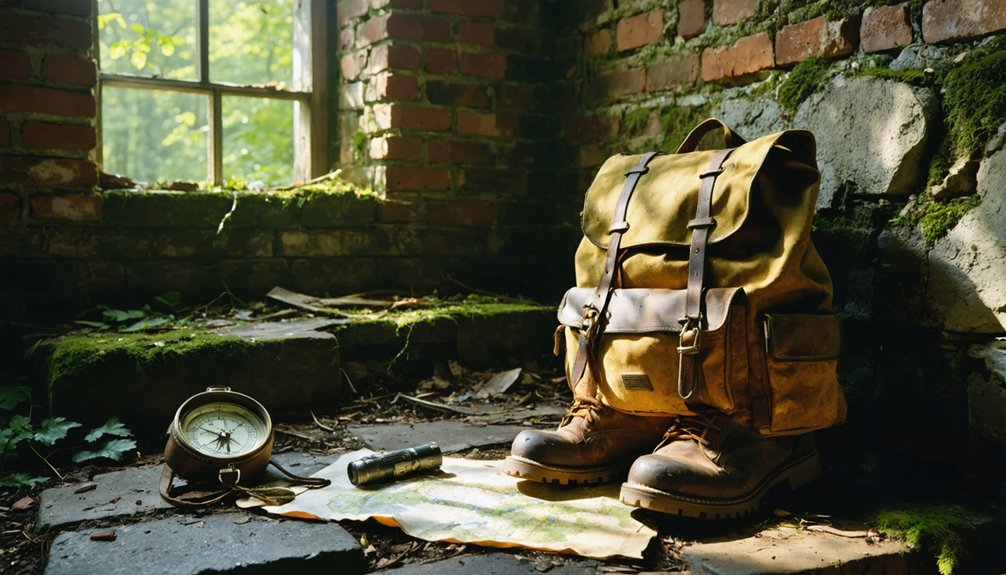
Why do seasoned ghost town explorers pack twice what beginners consider necessary? Because Tahawus’s abandoned mines and Doodletown’s 30+ foundations demand preparation you’ll curse yourself for skipping.
Your waterproof jacket shields against Adirondack downpours while documenting crumbling structures. Offline GPS maps prove lifesaving when cell signals vanish near Pottersville’s trails. Pack that first-aid kit—rusted nails and unstable debris don’t care about your adventure plans.
Cell signals die in ghost towns—offline maps and first-aid kits separate prepared explorers from stranded ones.
Bring cameras for historical preservation, capturing fading foundations before nature reclaims them entirely. Bug spray isn’t optional; black flies show no mercy during summer expeditions.
Your sturdy boots protect ankles on uneven terrain while respecting wildlife protection zones around Bear Mountain.
Cash enables spontaneous guided tours revealing stories printed guides miss. Pack out everything—these forgotten places deserve your respect, not your trash.
Safety Tips for Visiting Abandoned Sites
Your backpack’s packed, but one oversight transforms exploration into a legal nightmare or medical emergency. Before stepping through that weathered doorframe, understand New York’s trespassing laws—simple violations carry 15 days jail time, while criminal charges escalate to 90 days.
Structural hazards multiply with each season: decayed floors collapse without warning, asbestos particles drift through stagnant air, and rusted metal waits beneath debris piles.
Protect yourself with these essentials:
- Secure written permission from property owners before entry
- Test floor stability with extended poles before walking
- Share your location and expected return time with contacts
- Explore during daylight with fully-charged communication devices
Ghost town adventures shouldn’t cost you your freedom or health—smart preparation separates memorable discoveries from regrettable consequences.
Best Times of Year to Explore Ghost Towns in New York
When golden leaves transform the Adirondack wilderness into a painter’s canvas, late September through October becomes the undisputed champion for ghost town exploration.
Autumn’s golden transformation crowns late September through October as the ultimate season for discovering the Adirondacks’ abandoned settlements.
You’ll find Tahawus’s rusted machinery glazed with early frost, creating that perfect blend of urban decay and natural reclamation. The cooler temperatures mean you won’t collapse hiking to remote mines, and crunching leaves beneath your boots amplify the eerie atmosphere.
October sweetens the deal with Halloween festivities in nearby towns—Saranac Lake’s haunted walks or Inlet’s parades complement your ghost town adventures.
Winter brings snowshoeing opportunities at Camp Santanoni, though Tahawus Road becomes challenging. Spring and summer work too, but autumn delivers that cinematic experience adventurers crave while supporting historical preservation through increased interest in these forgotten places.
Photography Opportunities at New York’s Abandoned Locations
Before you even lift your camera, New York’s abandoned locations reveal themselves as a photographer’s fever dream—corroded ironwork bleeding rust onto weathered brick, nature’s patient fingers prying apart what industry built.
Frame these compositions for maximum impact:
- Tahawus’s blast furnace silhouetted against Adirondack peaks, where seasonal lighting transforms morning fog into ethereal curtains.
- Doodletown’s concrete stairs ascending into emptiness, stone foundations outlining ghost houses beneath autumn’s copper canopy.
- Ellis Island’s mortuary windows capturing cross-light through deteriorating frames—historical architecture meeting decay.
- Frontier Town’s warped structures creating surreal geometry off Exit 29.
Winter strips away visual clutter, exposing skeletal frameworks.
Summer’s overgrowth at Camp Santanoni adds layered textures.
Shoot Renwick Hospital from a distance during golden hour when crumbling Gothic Revival details catch fire against East River reflections.
Frequently Asked Questions
Are There Guided Tours Available for New York’s Ghost Towns?
You won’t find official guided tours for New York’s abandoned ghost towns—they’re off-grid destinations you’ll explore independently. Urban exploration here means discovering hidden histories on your own terms, *searching through* crumbling structures and overgrown paths without restrictions.
Among the most intriguing are the ghost towns in New York state, where remnants of past lives linger in the shadows. Each site offers a unique glimpse into history, showcasing architecture and artifacts that tell stories of the people who once inhabited these areas. As you wander through these forgotten places, you’ll encounter both beauty and decay, sparking your imagination about what life was like in these now-silent communities.
Do I Need Special Permits to Visit These Abandoned Locations?
Most sites don’t require permits—Doodletown and Tahawus welcome you freely. However, safety concerns limit North Brother Island access, and Love Canal’s accessibility requirements keep visitors out. You’ll find open trails outweigh restrictions across New York’s ghost towns.
Can Children Safely Visit New York’s Ghost Towns?
Children can safely visit select ghost towns like Doodletown with proper supervision and preparation. Safety considerations include sturdy footwear, guided tours, and avoiding hazardous sites. Family-friendly activities work best on maintained trails rather than unstable structures or contaminated areas.
Are There Any Hotels Near These Ghost Town Locations?
Your basecamp options bloom across regions—Bear Mountain Inn sits 5 miles from Doodletown for urban exploration, while Adirondack Loj near Tahawus offers photography tips access. You’ll find freedom staying in surrounding towns, though North Brother remains inaccessible overnight.
What Historical Documents Exist About These Abandoned New York Communities?
You’ll find Adirondack Park Agency records documenting Tahawus’s iron operations, WPA Federal Writers’ Project manuscripts on paranormal folklore, and reservoir construction reports. These historical preservation documents reveal archaeological findings from displaced communities, offering you authentic glimpses into lost worlds.
References
- https://943litefm.com/abandoned-ghost-towns-new-york/
- https://en.wikipedia.org/wiki/List_of_ghost_towns_in_New_York
- https://www.onlyinyourstate.com/experiences/new-york/ghost-towns-ny
- https://wyrk.com/new-york-state-ghost-town/
- https://www.atlasobscura.com/things-to-do/new-york-state/abandoned
- https://visitadirondacks.com/fall/abandoned-places-ghost-towns
- https://www.geotab.com/ghost-towns/
- https://www.youtube.com/watch?v=Nw2j2-YSknU
- https://theghostinmymachine.com/2025/01/13/abandoned-the-last-remnants-of-doodletown-new-york/
- https://rooseveltislanddaily.news/2019/04/24/doodletown-suburban-ghost-town/