
You’ll find Oklahoma’s most haunting ghost towns scattered across red dirt plains and forgotten highways. Picher stands evacuated after a century of toxic mining, while Texola crumbles along Route 66’s faded asphalt. Kusa disappeared completely within twenty years, leaving only archival memories. Boggy Depot preserves Choctaw trading history, and Ingalls marks where marshals battled the Doolin-Dalton Gang in 1893. Acme’s concrete ruins tell of gypsum glory that lasted barely a decade. Each site reveals the brutal economics and dramatic stories that shaped Oklahoma’s frontier past.
Key Takeaways
- Picher offers toxic chat piles and tornado-damaged remnants from its former lead and zinc mining operations that employed 14,000 workers.
- Texola preserves Route 66 history with faded service stations, overgrown streets, and a 1910 cinderblock jail along Oklahoma’s western border.
- Ingalls features the site of an 1893 gunfight between U.S. Marshals and the Doolin-Dalton Gang, located east of Stillwater.
- Acme displays crumbling concrete ruins from a 1911 gypsum mining company town that produced plaster for American cities until 1931.
- Boggy Depot showcases a Choctaw trading post and territorial capital with Oklahoma’s first Masonic Lodge and Civil War Confederate supply history.
Picher: Oklahoma’s Toxic Mining Legacy and Total Evacuation
In 1913, Harry Crawfish’s lead and zinc discovery transformed northeastern Oklahoma into the nation’s most productive mining operation, but what began as an economic miracle became America’s most cautionary tale of environmental devastation.
You’ll find Picher produced over $20 billion in ore through 1947, employing 14,000 miners who hollowed out the earth beneath their own homes. When operations ceased in 1967, they left 70 million tons of toxic chat piles and 14,000 abandoned shafts.
By 2006, 86 percent of structures risked collapse into undermined ground. Environmental remediation proved impossible—the government chose total community relocation instead. Over 200 families relocated with federal aid within two years as severe environmental hazards made the town uninhabitable. A 2008 EF4 tornado delivered the final blow, killing at least 150 people and destroying over 20 blocks of the already-dying town.
Today, you can witness where freedom’s price was paid: crumbling foundations, rust-orange waterways, and mountains of poisoned tailings stretching across an abandoned landscape.
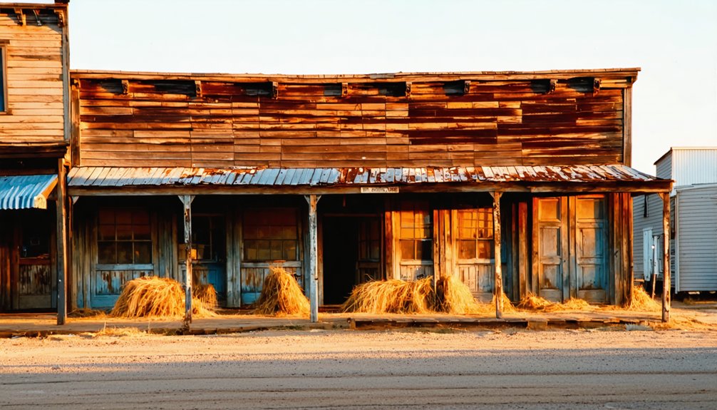
Texola: Route 66 Relic on the Texas Border
While Picher’s story warns of industrial catastrophe, Texola whispers a different kind of ending—the slow fade of a highway town left behind by progress. You’ll find Oklahoma’s westernmost Route 66 stop clinging to the Texas border, where bleached Magnolia Service Station signs mark what was once the Will Rogers Highway’s liveliest stretch.
Texola’s fading service stations and empty streets tell the story of a Route 66 town abandoned by the interstate’s arrival.
In 1930, 581 souls called this home—cotton gins hummed, hotels bustled, travelers stopped for gas and gossip.
Then I-40 arrived, and everything changed.
Today, 40 residents remain among derelict storefronts and that curious cinderblock jail from 1910. It’s cultural tourism at its rawest: no polish, no gift shops, just honest decay. Local legends speak of better days, but you’re here for the truth—freedom means witnessing what progress leaves behind. Overgrown weeds surround the abandoned buildings, nature reclaiming what commerce once owned. Steinbeck immortalized this dusty crossroads in “The Grapes of Wrath”, capturing the desperation of Dust Bowl migrants who passed through seeking California dreams.
Kusa: The Coal Boomtown That Vanished in 20 Years
You’ll find almost nothing left of Kusa today except a lonely road sign and “No Trespassing” warnings blocking the overgrown site where 3,500 people once lived.
This coal and zinc smelting boomtown exploded into existence in 1916 with newspapers, banks, a movie theater, and daily railroad service. Then completely vanished by the mid-1930s when the mines closed and the trains stopped coming. The industries ended by late 1920s, leaving behind only scattered foundations and overgrowth where a thriving community once stood. Kusa’s decline began after the railroad bypassed the town in favor of nearby Henryetta.
Drive northeast of Henryetta on Highway 266, and you’ll pass Kusa Road without realizing an entire city once thrived there, swallowed by time faster than almost any town in Oklahoma history.
Rapid Rise and Fall
Though Kusa officially incorporated on March 27, 1916, the town had already begun its meteoric transformation from empty prairie into Oklahoma’s most ambitious coal boomtown. You’d have witnessed 3,500 residents flooding in, chasing prosperity through zinc smelting and coal extraction.
The town’s infrastructure told its story:
- Financial institutions and entertainment venues lined streets that hadn’t existed two years prior.
- Rock Island and Katy railroad lines delivered daily shipments connecting miners to national markets.
- A dedicated power plant illuminated operations around the clock.
- The Kusa Industrial newspaper documented this frontier capitalism in real-time.
Then 1928 arrived. Zinc production ceased, mines shuttered, and railroads rerouted to Henryetta. Economic decline accelerated into urban decay within months, leaving only photographs and microfilm to prove this empire ever existed. At its peak, Kusa stood as the largest town in Okmulgee County, a testament to the explosive growth that coal and lead smelting brought to this corner of Oklahoma. Today, all old structures have been torn down, with only foundations marking where theaters, hotels, and banks once thrived.
What Remains Today
If you drive US Highway 266 through Okmulgee County today, you’ll pass within striking distance of Kusa without knowing it. The town lies east northeast of Henryetta, hidden behind No Trespassing signs and thick overgrowth.
Kusa Road survives as the only named feature marking where thousands once lived and worked.
You won’t find industrial relics or standing structures from public vantage points. The 1919 coal mine and smelting facilities documented in historical photographs have vanished completely.
What remains exists only in archives—Harvey Thrailkill’s 1960s album and Oklahoma Historical Society records preserve what your eyes can’t see.
Unlike Picher’s toxic legacy, Kusa simply disappeared into private property after 1928. No ghost stories circulate because nobody’s allowed close enough to create them. About four miles north of Burbank in Osage County, Whizbang’s remnants tell a different story—sidewalks and rubble still mark where the oil boomtown once thrived before its post office closed in 1942. Nearby Seminole County experienced similar boom-and-bust cycles, with its population surging from 23,808 to 79,621 between 1920 and 1930 as oil discoveries transformed the region.
Boggy Depot: Ancient Choctaw Trading Post and Territorial Capital
Walk where history unfolded through:
- The Butterfield Overland Stage route connecting Missouri to San Francisco.
- Oklahoma’s first Masonic Lodge perched above Reverend Kingsbury’s church.
- Confederate supply operations during the nearby Battle of Middle Boggy.
- The 1872 railroad bypass that sentenced this thriving community to abandonment.
Today’s preserved site lets you explore authentic frontier commerce, tribal sovereignty, and the untamed transportation networks that shaped territorial Oklahoma.
Ingalls: Wild West Shootout Site and Dalton Gang Battleground
When the morning sun broke over Ingalls on September 1, 1893, nobody anticipated the dusty streets would soon run red with blood from one of the Old West’s fiercest gunfights.
September 1, 1893: A peaceful morning in Ingalls transformed into one of the deadliest shootouts in Old West history.
You’ll find this ghost town 6-10 miles east of Stillwater along Highway 51, where a historical marker commemorates the day 27 U.S. Marshals cornered the Doolin-Dalton Gang in Ransom Saloon.
The outlaws, who’d made Ingalls one of their favorite outlaw hideouts after the Coffeyville disaster, shot their way from the saloon to the livery stable.
Eight horses died in the crossfire.
Three marshals and two townspeople fell before all gang members except Arkansas Tom Jones escaped.
These historic gunfights cost the gang everything—each escapee eventually died by lawmen’s bullets, proving you can’t outrun justice forever.
Acme: The Gypsum Mining Town That Returned to Dust
When you stand among Acme’s crumbling concrete ruins today, you’ll witness the skeleton of what was once a thriving company town where 125 workers loaded eight railcars daily with gypsum plaster.
The Acme Cement and Plaster Company built an entire community around its 1911 mill—constructing houses, a general store, and a brick schoolhouse before the gypsum beds ran dry after just a dozen years.
What makes Acme’s story particularly haunting is how completely it vanished: when the machinery had to be removed, workers literally tore down the buildings that had been constructed around those massive industrial components.
Gypsum Industry Boom Era
Deep in Grady County, the skeletal concrete ruins of Acme stand as weathered monuments to Oklahoma’s gypsum boom, when this industrial outpost hummed with the machinery of progress and promise.
Between 1911 and the early 1920s, you’d have witnessed Acme’s golden era:
- Industrial architecture rose around massive equipment—buildings literally constructed to house the machinery rather than the reverse.
- Six to eight railcar loads departed daily on the Rock Island spur, carrying processed plaster and cement across America.
- 125 workers clocked in regularly, their paychecks sustaining community life through boarding houses and the general store.
- Gypsum beds yielded their mineral treasure continuously, transforming raw earth into construction materials that built cities.
The plant’s thunderous operations defined freedom through self-reliance and honest labor, before nature reclaimed what progress briefly borrowed.
Company Town Model
As Acme Cement and Plaster Company broke ground in 1911, they didn’t just build a factory—they engineered an entire world around their machinery.
This company town rose from Oklahoma’s gypsum-rich earth, complete with a power plant, boarding houses, a general store, and even a post office that served the industrial community from 1913 to 1931.
You’d have found 100 to 125 workers living and laboring here at peak production, loading six to eight railcars daily with processed gypsum.
The Chicago, Rock Island and Pacific Railroad spur became the lifeline connecting this self-contained settlement to distant markets.
Every structure served the mill’s appetite for labor and efficiency.
When the gypsum ran out, so did the town’s reason for existing—pure industrial pragmatism in action.
Resource Depletion and Abandonment
Within a dozen years of that first shovel breaking earth, Acme’s gypsum beds had surrendered everything they’d to give. You’ll find the environmental restoration nature provides came through catastrophe—1927’s floods buried the company’s desperate narrow-gauge extension beneath feet of suffocating sand.
Economic decay followed swiftly:
- Workers excavated frantically but couldn’t justify the mounting costs against Depression-era market realities.
- Six to eight daily railcar loads dwindled to zero as the mill’s machinery fell silent in 1930.
- Buildings came down piece by piece, their valuable equipment salvaged while concrete shells remained.
- The post office closed May 29, 1931, marking Acme’s official transformation from thriving company town to windswept ruins.
Today’s crumbling foundations remind you that freedom sometimes means walking away.
Frequently Asked Questions
Are Any Oklahoma Ghost Towns Safe for Overnight Camping or RVING?
No, Oklahoma’s ghost towns aren’t safe for overnight stays. Haunted legends aside, Picher’s toxic contamination and Nowata’s abandoned structures create hazardous conditions. You’ll find your freedom better served at designated campgrounds or rest areas where you can legally park overnight.
Exploring annual events in ghost towns can be an intriguing way to experience a piece of history, but safety must always come first. Many locations host festivals and activities that celebrate their rich, albeit eerie, heritage. Just ensure you’re well-informed about the area’s conditions before planning your visit.
Which Ghost Towns Require Permits or Permission to Visit Legally?
You’ll need landowner permission before exploring any ghost town on private property—it’s required by law. Most Oklahoma ghost towns have access restrictions since they’re privately owned. Always secure written consent first to avoid trespassing charges and fines.
Additionally, the ghost towns of Oklahoma history offer a glimpse into the past, showcasing abandoned structures and remnants of once-thriving communities. Each site tells a unique story, reflecting the boom and bust cycles that shaped the region. As you venture out, take time to appreciate the history that these forgotten places preserve.
As you explore ghost towns in Oklahoma, keep an eye out for the fascinating artifacts left behind that narrate their stories. Each town has its own character, with remnants ranging from dilapidated buildings to overgrown streets that transport you back in time. These sites not only serve as a reminder of the past but also offer an incredible opportunity for photography and discovery.
What’s the Best Time of Year to Tour Oklahoma Ghost Towns?
Fall’s golden light becomes your compass—visit Oklahoma’s ghost towns mid-September through November when seasonal weather cools to comfortable exploration temperatures and tourist crowds thin out, giving you uninterrupted freedom to wander these forgotten places at your own pace.
Are Guided Ghost Town Tours Available in Oklahoma?
You’ll find limited guided ghost town tours in Oklahoma, mainly self-guided options through Pocketsights. These routes showcase historical folklore and preservation efforts across abandoned settlements, letting you explore Creek, Lincoln, Payne, and Pawnee Counties independently.
As you delve into these ghost towns to explore in Oklahoma, you’ll uncover intriguing stories of the past and witness remnants of once-thriving communities. Each site offers a unique glimpse into the lives that shaped the state, with many structures still standing as a testament to their history. Make sure to capture the eerie beauty of these locations during your visit, as they provide a perfect backdrop for photography and reflection.
Can You Metal Detect or Collect Artifacts at These Sites?
You’ll need to navigate treasure hunting restrictions carefully. Historical preservation and artifact regulations limit collecting at most sites—you’ll require permits for public lands, landowner permission for private property, and some locations remain completely off-limits to detectors.
References
- https://oktttp.genealogyvillage.com/ghost_towns/ghost_towns.htm
- https://kids.kiddle.co/List_of_ghost_towns_in_Oklahoma
- https://www.ghosttowns.com/states/ok/ok.html
- https://www.youtube.com/watch?v=5d-wHDTIbb0
- https://pocketsights.com/tours/tour/Shamrock-Oklahoma-Ghost-Towns-Creek-Lincoln-Payne-and-Pawnee-Counties-2749
- https://abandonedok.com/class/disappearing-town/
- https://www.okhistory.org/publications/enc/entry?entry=GH002
- https://adamthompsonphoto.com/the-sad-tale-of-picher-oklahoma/
- https://www.youtube.com/watch?v=yGZeoW8lLdU
- https://en.wikipedia.org/wiki/Picher


