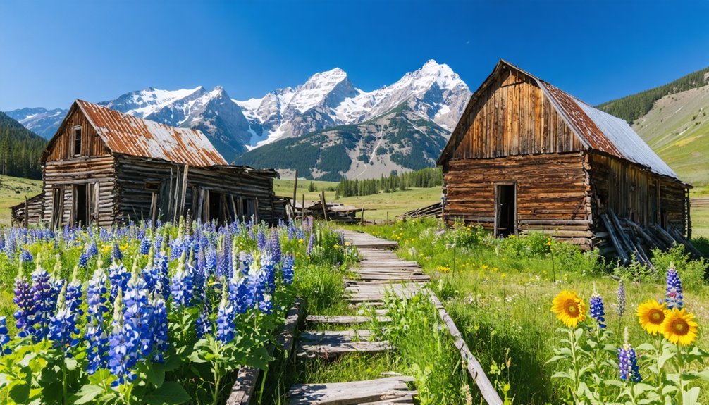
You’ll find Colorado’s best spring ghost towns along mountain passes that shake off winter’s grip between April and June. St. Elmo stands remarkably intact with its 1880s storefronts lining Chalk Creek, while Animas Forks clings to windswept slopes at 11,200 feet. Tin Cup’s Boothill Cemetery tells darker tales of frontier justice, and Vicksburg’s cabins nestle among balsam poplars near Leadville. Pack layers and check road conditions before venturing out—snowmelt transforms accessibility daily, and these weathered settlements reward those who time their visits right with secrets hidden in every creaking doorway.
Key Takeaways
- St. Elmo offers well-preserved 1880s buildings including hotels, saloons, and a schoolhouse, with scenic Chalk Creek and Sawatch Range views.
- Animas Forks sits at 11,200 feet featuring weathered structures like Duncan House, accessible via 4WD along the Alpine Loop from Silverton.
- Tin Cup, 35 miles northeast of Gunnison, showcases notorious outlaw history with Boothill Cemetery marking its violent law enforcement struggles.
- Spring access depends on snowmelt and elevation; verify road conditions beforehand as high passes may remain impassable until May.
- Pack layers, sun protection, GPS, maps, and emergency supplies for remote high-altitude exploration with limited cell service.
St. Elmo: A Well-Preserved Mining Town Along Chalk Creek
Perched at nearly 10,000 feet in a narrow canyon carved by Chalk Creek, St. Elmo stands as one of Colorado’s finest examples of historical preservation. You’ll find intact structures from its 1880s heyday—five hotels, weathered saloons, a general store, and schoolhouse—all frozen in time along dirt streets where nearly 2,000 souls once chased silver dreams.
A perfectly preserved 1880s silver town where 2,000 dreamers once lived, now frozen in time at 10,000 feet.
The mining history here runs deep. Prospectors discovered rich deposits in 1875, and within years, operations like the Mary Murphy Mine shipped 75 tons of ore daily from mountainsides 2,000 feet above town. The area boasted 150 patented claims, though few owners struck profitable veins.
Spring reveals the raw beauty that captivated those early fortune-seekers—snowmelt rushing through Chalk Creek, abandoned mining roads beckoning exploration, and the Sawatch Range towering overhead. The town shares its name with St. Elmo Hall, a building once owned by Yale University’s secret society.
It’s accessible adventure without crowds.
Animas Forks: High-Altitude Ghost Town in the San Juan Mountains
At 11,200 feet where three mountain rivers converge, Animas Forks clings to the San Juan Mountains as Colorado’s highest ghost town—a windswept cluster of weathered structures that defied brutal alpine conditions for nearly five decades.
You’ll discover mining history etched into every weathered plank of the dozen remaining buildings. The two-story Duncan House and Frisco Mill stand as proof to prospectors who struck gold and silver here in 1873, building a 450-person community that survived a 23-day blizzard burying everything under 25 feet of snow. Otto Mears constructed a wagon road to the mining camp in 1875, enabling the transport of ore and supplies that fueled the town’s prosperity through the 1880s. Residents dug tunnels between buildings through packed snow to survive the harsh winter conditions.
High altitude exploration demands a capable 4WD vehicle traversing 12 miles northeast from Silverton along the legendary Alpine Loop. Spring reveals this National Register site emerging from winter’s grip, its isolation and preservation offering unfiltered glimpses into Colorado’s raw frontier past.
Vicksburg: Historic Mining Camp in Clear Creek Canyon
Where Clear Creek Canyon carves through granite walls twelve miles west of Leadville, Vicksburg spreads across a narrow valley floor—a confirmation to the gold-fevered chaos of 1867 when lost pack burros stumbled upon glittering creek-bed deposits that would birth an entire mining camp.
You’ll walk streets where balsam poplars still stand, planted by miners who packed saplings on burro-back through mountain passes.
Mining history breathes through seven surviving cabins and the Swiss Boy Mine remnants that once sustained 700 souls.
Wooden cooling boxes line original street ditches, proof to frontier ingenuity.
Preservation efforts by Chaffee County Historical Society transformed two buildings into museums, while privately-owned cabins harbor modern-day prospectors seeking solitude.
The camp took its name from Vick Keller, who operated the general store that became the community’s commercial heart.
The National Register designation in 1977 protects this canyon sanctuary where spring snowmelt roars through the same creek that sparked Colorado’s endless pursuit.
The name Vicksburg itself appears across multiple locations nationwide, reflecting the widespread influence of Civil War history on western settlement naming conventions.
Winfield: Remote Settlement With Maintained Historic Buildings
Four miles deeper into Clear Creek Canyon’s wilderness, Winfield clings to the north and south forks junction—a remote settlement where maintained historic buildings outnumber seasonal residents who open cabin doors each summer. You’ll escape urban development completely here, fourteen miles west of Highway 24 on a road that tests your vehicle’s clearance past the campground.
Where historic buildings outnumber people and maintained cabins await summer visitors at the remote forks junction.
The 1889 schoolhouse stands as Winfield’s crown jewel, its modern restoration transforming weathered walls into a working museum. Inside, you’ll find furnishings and a recorded message chronicling 1,500 souls who chased silver until the 1893 crash. The community once supported three saloons, three stores, two hotels, a church, and a boarding house during its prosperous mining days.
Ball Cabin displays mining relics across the dirt street.
Twenty-six cemetery graves tell harder stories—fires, snowslides, shootings marking lives lived beyond civilization’s reach. The place name shares its designation with locations across the country, distinguished by this canyon settlement’s mining heritage. Respect the “no trespassing” signs; freedom here means honoring boundaries.
Independence: Alpine Ghost Town Near Aspen
Sixteen miles southeast of Aspen, Independence sprawls across windswept terrain at 10,900 feet—where alpine air bites your lungs and Highway 82 carves through mountains toward Independence Pass. Founded as a tent camp in 1879, this ghost town exploded to 1,500 souls chasing gold strikes, then collapsed when railroads bypassed it for Aspen’s warmer valleys.
Local folklore whispers of the 1899 blizzard that drove out all but one stubborn resident.
Preservation efforts by the Aspen Historical Society keep original structures standing—boarding houses, a stable, the Farwell Stamp Mill. You’ll wander dirt trails connecting weathered cabins, peer into a small museum’s mining artifacts, and read interpretive signs revealing each building’s story. The easy, 1-mile round trip from the trailhead makes this ghost town accessible for most visitors. Tours operate 10 am to 6 pm during the summer season, with a suggested $5 donation supporting ongoing archaeological preservation.
Guided tours run mid-June through Labor Day, though you’re free to explore independently once Highway 82 opens seasonally.
Tin Cup: Colorado’s Most Notorious Mining Camp
You’ll find Tin Cup nestled at 10,000 feet where criminals once ruled with such ferocity that marshals died in gunfights with alarming regularity, their gravestones now marking one of Colorado’s most haunting cemeteries.
The town’s violent legacy seeps through weathered wooden buildings that survived two devastating fires, each structure whispering stories of fortune seekers who arrived by the thousands during the 1880s boom.
Spring’s melting snow reveals Forest Service roads winding toward this isolated camp, where you can walk among original storefronts and trace the bloodstained path of lawmen who dared challenge the underworld’s grip.
Lawless Past and Legacy
While most Colorado mining camps struggled with occasional violence, Tin Cup earned its reputation as the state’s most notorious outpost through systematic criminal control that lasted decades. The underworld’s criminal influence ran so deep that even honest sheriffs couldn’t operate without approval from crime bosses.
Those who defied this twisted legal history faced deadly consequences—town marshal Harry Rivers died in an 1882 gunfight, and his replacement Andy Jameson met the same fate just a year later.
You’ll find their graves in the local cemetery alongside other lawmen and citizens who refused to bend. This wasn’t temporary frontier chaos—it was organized crime that persisted through the entire mining era.
The fires of 1906 and 1913 eventually destroyed what lawlessness couldn’t.
Cemetery Tales and History
The Boothill Cemetery sits just south of town, a windswept plot where wooden markers and weathered stones tell stories of lives cut short by bullets rather than old age. You’ll find Marshal Harry Rivers here, gunned down in 1882, and Andy Jameson, who met the same fate in 1883.
These lawmen refused to bow to the criminal underworld that controlled Tin Cup‘s lucrative mineral rights. The cemetery’s filled with honest sheriffs who wouldn’t take orders from outlaws—and paid with their lives.
Today, ghost stories swirl around these graves during summer visits. Each marker represents Tin Cup’s darkest era, when arriving marshals faced a simple choice: comply with the underworld’s demands or join the growing collection of “good people” buried in Boothill’s unforgiving soil.
Accessibility and Nearby Routes
Tucked away thirty-five miles northeast of Gunnison city, Tin Cup challenges modern visitors with the same remoteness that once kept railroad barons at bay. You’ll find several local access routes threading through mountain passes—Cottonwood Pass winds from west of Buena Vista, while Taylor Canyon cuts through from Almont’s eastern edge. Cumberland Pass offers northern entry from Pitkin, and the dramatic Tincup Pass carries you straight across the Continental Divide.
Spring brings unpredictable seasonal road conditions here. Heavy snowmelt lingers on high passes well into May, making summer your safest bet for exploration. Colorado Road 765 past Taylor Park Reservoir provides your most reliable approach. From Crested Butte, you’re looking at a ninety-minute drive through country where cell service fades and self-reliance becomes essential—exactly how ghost town hunting should feel.
Planning Your Spring Ghost Town Adventure
Spring transforms Colorado’s abandoned mining camps from snow-locked relics into accessible destinations. But timing your visit requires careful attention to elevation and weather patterns. You’ll want to monitor road conditions obsessively—unpaved routes can shift from passable to treacherous within hours as seasonal weather brings sudden storms and temperature swings.
Pack layers for dramatic elevation changes and bring sun protection; UV rays intensify mercilessly above 11,000 feet, even in cool air. Check forecasts before departure and always verify current accessibility with local sources.
Travel safety demands respect for these high-altitude routes—carry GPS, detailed maps, and emergency supplies. Late May through early fall offers your best window, when 2WD vehicles can navigate most ghost town roads without wrestling impassable snowpack or ice-slicked switchbacks.
What to Bring for Ghost Town Exploration
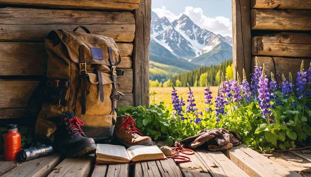
Beyond route planning and weather monitoring, your pack determines whether you’ll explore comfortably or retreat early from these high-altitude relics. Layer synthetic fabrics for elevations topping 11,000 feet—temperatures plunge to -30°F even as spring arrives.
Waterproof jackets shield you from sudden hailstorms, while sturdy boots grip unpaved Alpine Loop trails. Don’t skimp on clothing essentials: warm gloves, hats, and UV protection matter at altitude.
Your safety gear separates adventure from crisis in these remote San Juan sites. Pack first-aid supplies for orienteering crumbling mine ruins, flashlights for pitch-black cabins, and emergency blankets when weather shifts violently.
Bring paper maps and GPS—cell service vanishes above treeline. A multi-tool, whistle, and bear spray complete your kit for true self-reliance in Colorado’s abandoned mountain strongholds.
Combining Multiple Ghost Towns in One Trip
Colorado’s ghost town clusters reward strategic route planning with a tapestry of mining histories spanning a single day. You’ll maximize your spring exploration by pairing nearby sites that share access routes but offer distinct stories.
Consider these proven combinations:
Strategic pairings transform scattered ghost towns into cohesive day trips, linking complementary mining narratives through shared mountain passages.
1. St. Elmo and Tin Cup – Regular cars handle this western Buena Vista pairing, where wooden storefronts shift to cemetery tales of short-lived sheriffs.
2. Animas Forks and Carson – The 65-mile Alpine Loop connects these high-altitude camps (11,000 and 12,000 feet).
The route threads Continental Divide terrain with mountain vistas between restored buildings.
3. Vicksburg and Winfield – Clear Creek Canyon’s poplar-lined route delivers audio-guided mining stories plus log cabin museums.
Near wildflower hikes, these sites offer a scenic and educational experience.
4. Alta and Alta Lakes – Telluride’s National Register site extends into alpine recreation.
It blends 1877 boarding houses with lakeside camping freedom.
Frequently Asked Questions
Are Pets Allowed When Visiting Colorado Ghost Towns in Spring?
Yes, you’ll find most Colorado ghost towns welcome leashed pets during spring visits. Pet policies vary by site, but spring weather’s perfect for exploring with your four-legged companion. Just keep them leashed and respectful of historic surroundings.
Do Any Ghost Towns Charge Admission Fees or Require Permits?
Yes, you’ll pay admission fees at several ghost towns. Ghost Town Museum charges $8.50 for adults, while South Park City and Ashcroft cost $5. No special permits are required—just show up and explore these authentic Western remnants freely.
Are Ghost Town Buildings Safe to Enter or Only Viewable Externally?
Most ghost town buildings aren’t safe to enter—you’ll find structural safety concerns and historical preservation efforts restrict interior access. You’re free to explore exterally, capturing weathered facades and imagining stories while respecting crumbling walls that whisper danger.
What Cell Phone Coverage Exists in Remote Ghost Town Locations?
You’ll find virtually no cell signal at most remote ghost towns, especially above 10,000 feet. Coverage limitations stem from rugged terrain and infrastructure costs. Download offline maps beforehand—these backcountry sites demand true self-reliance and disconnection from the grid.
Can You Camp Overnight Near These Ghost Towns During Spring?
Like a bird finding its nest, you’ll discover overnight camping near most ghost towns. Camping restrictions vary by location, but dispersed forest sites welcome your freedom. Spring weather considerations demand preparation—pack layers, check snowmelt conditions, and embrace Colorado’s untamed backcountry adventures.
As you explore ghost towns in colorado summer trips, take the time to learn about the rich history and captivating stories each site holds. Many ghost towns offer hiking trails that lead to breathtaking vistas, showcasing the natural beauty of the Rocky Mountains. Whether you’re interested in photography, history, or simply immersing yourself in nature, these unique locales provide endless opportunities for adventure.
References
- https://en.wikipedia.org/wiki/List_of_ghost_towns_in_Colorado
- https://creeksidechalets.com/ghost-towns-near-salida/
- https://mtprinceton.com/project/st-elmo/
- https://www.visitouray.com/ghost-towns
- https://www.colorado.com/articles/colorado-ghost-towns
- https://www.uncovercolorado.com/ghost-towns/
- https://www.duntondestinations.com/hot-springs/
- https://www.pikes-peak.com/attractions/ghost-town-museum/
- https://www.tripadvisor.com/Attractions-g28927-Activities-c47-t14-Colorado.html
- https://www.historynet.com/ghost-town-st-elmo-colorado/


